
Kabul River
| Kabul River | |
|---|---|
Pashto) | |
| Location | |
| Countries | Afghanistan and Pakistan |
| Cities | Kabul, Surobi, Jalalabad (Afghanistan); Peshawar, Charsadda, Nowshera (Pakistan) |
| Physical characteristics | |
| Source | Hindu Kush Mountains |
| • location | Maidan Wardak, Afghanistan |
| • coordinates | 34°21′25″N 68°50′21″E / 34.357°N 68.8392°E |
| • elevation | 2,400 m (7,900 ft) |
| Mouth | Indus River |
• location | Attock, Punjab, Pakistan |
• coordinates | 33°55′0″N 72°13′56″E / 33.91667°N 72.23222°E |
| Length | 700 km (430 mi) |
| Basin size | 70,500 km2 (27,200 sq mi) |
| Basin features | |
| Tributaries | |
| • left | Panjshir River, Alingar River, Kunar River, Swat River |
| • right | Logar River, Surkhab River, Bara River |
The Kabul River (
Course
The Kabul River, which measures 700 kilometres or 430 miles long, passes through the cities of
Hydrology
The Kabul River is little more than a trickle for most of the year, but swells in summer due to melting snows in the Hindu Kush Range. Its largest tributary is the Kunar River, which starts out as the
Dams
The Kabul River is impounded by several dams that were constructed in the 20th century. Three dams are located in the Kabul and Nangarhar provinces of Afghanistan, including the Surobi dam, a hydroelectric source for Kabul constructed 1957 with assistance by Germany, the Naghlu dam, which was later built by Soviet scientists in the 1960s, and the Darunta dam. The Warsak Dam is also in the Valley of Peshawar in Pakistan, approximately 20 km northwest of the city of Peshawar.[1]
History
Expedition of Alexander the Great into Asia
In
Modern era
Since the 1990s, the river has experienced substantial droughts in summer.[1] In approximately March 2019, ten of thousands of gallons of untreated sewage from the Makroyan Waste Water Treatment Plant has been dumped into the Kabul River each month, reportedly causing gastrointestinal issues among the 3,000 families that live along the river.[7]
Etymology
In Sanskrit and Avestan
The word Kubhā which is the ancient name of the river is both a Sanskrit and Avestan word. The word later changed to Kābul.[8][9]
Al-Biruni
Al-Biruni a Persian polymath also called it "the River of Ghorwand".[10]
The Kabul River later gave its name to the region and to the settlement of Kabul.[10]
Institution Leadership
Kabul River Basin (KRB) is a government authority under the Ministry of Energy and Water (MEW) of the Government of the Islamic Republic of Afghanistan (GoIRA). Based on the Water Law it was created. The recent Director General of this major water institution was Jalal Naser Faqiryar, who brought positive changes, contributed a lot to the transparency, basin development, and applicable policies, especially river basin management which had positive impacts and results.
Gallery
-
 The Kabul River in the city of Kabul, 1966
 -
 The Kabul River in the city of Kabul, 1982
 -
 The Kabul River in the city of Kabul in 2009, now dried up
 -
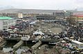 The dried river in the central city of Kabul
 -
 Kabul River valley
 -
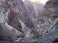 Gorge of the Kabul River, parallel to theKabul-Jalalabad Road
 -
 Kabul River in Behsood Bridge Area, Jalalabad, 2009
 -
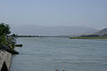 Kabul River in Behsood Bridge Area, Jalalabad, 2009
 -
 Buddhist caves, which have been carved into a set of cliffs on the north side of the Kabul river
 -
 A dam on the river
 -
 Kabul River at Behsood Bridge , Jalalabad


.jpg)

See also
References
- ^ a b c Wilde, A (April 19, 2012). "Kabul River".
- ^ "One Land, Two Rules (9): Delivering public services in insurgency-affected Jalrez district of Wardak province". Afghan Analysts Network. 16 December 2019. Retrieved 30 April 2020.
- ^ Arrian, John Rooke; Arrian (1813). "A brief account of all the authors who have touched upon the history of Alexander". Arrian's History of the expedition of Alexander the Great: and conquest of Persia. Translated by Rooke, John (2nd ed.). J. Davis.
- ISBN 1-904341-56-X.
- ISBN 0-415-96855-0.
- ISBN 0-87220-727-7.
- ^ Lawrence, J.P.; Babakarkhail, Zubair (September 12, 2020). "Sewage from US Embassy, NATO headquarters dumped into Kabul River due to aging infrastructure". Stars and Stripes. Archived from the original on September 15, 2020. Retrieved September 15, 2020.
- )
- as far as the Ganges, can be traced almost step by step in the later portions of the Vedic writings
- ^ a b Bosworth, C.E. (1999). "Kabul". Encyclopaedia of Islam (CD-ROM Edition v. 1.0 ed.). Leiden, The Netherlands: Koninklijke Brill NV.
External links
- Kabul River. Encyclopaedia Iranica.