
Kabwe
Kabwe | |
|---|---|
UTC+2 (CAT) | |
| Climate | Cwa |
Kabwe is the capital of the Zambian Central Province and the Kabwe District, with a population estimated at 202,914 at the 2010 census.[1] Named Broken Hill until 1966, it was founded when lead and zinc deposits were discovered in 1902. Kabwe also has a claim to being the birthplace of Zambian politics as it was an important political centre during the colonial period.[2][3]
Kabwe is an important transportation, farming and university centre. Kabwe is becoming a major agricultural hub for the country is the headquarters for Zambia Railways and prison services. Additionally the mining industry has been important to the economic development of the region. However, because of the exceptional contamination of the city with lead and other toxins, and the effects of these on local children's health, a March 2022 report by the UN Special Rapporteur on Human Rights and the Environment identified the town as a sacrifice zone for industry.[4]
History
Headquarters of Zambia Railways

The first railway in the country, operated by
The railway workers' unions played a large role in the politics of the country. In racially segregated colonial times before Africans had the vote, the town was the seat of
Today, the town is the headquarters of Zambia Railways but employment levels on the railway have been heavily cut.[citation needed]
Independence protest
Reflecting Kabwe's central location and railway union base, it was chosen as the site for a rally held on October 26, 1958, at
Districts
Makululu
A large informal settlement on the outskirts of the city, Makululu is an important district in the town.[5] The settlement is on the edge of the Lukanga Swamp, and is thus vulnerable to flooding.[5] Similarly, the water is highly contaminated from both poor sanitation and the broader industrial pollution from the mine.[citation needed]
Environmental issues
Mine pollution
A study by the
Other studies, have found high potential for copper, cobalt and other non-lead materials in leachate from the mine.[9]
A class action lawsuit was launched against Anglo American plc, alleging that it ignored the required safety standards despite knowing about the harms caused. Anglo-American was the majority owner of the mine from 1925 until its 1974 nationalization by the Zambian government. A certification hearing was held at the High Court of South Africa's Johannesburg branch in February 2023.[10]
Transportation
Kabwe is on the T2 road (Great North Road) to Kapiri Mposhi in the north and Lusaka in the south.[11] It is also on the Zambia Railways line.
On February 7, 2013, a bus collided with two cars near Kabwe, killing 53 people. It was one of the worst road accidents in Zambian history.[12][13]
Industries and agriculture
Historically the economy of Kabwe has been dominated by the mine. Other industries include pharmaceuticals, milling and cotton ginning, and Kabwe's first Drinking Water Plant (Aquador Purifed Water) and
To the east of the city are the hydro-electric power stations of the Mulungushi Dam, Mita Hills Dam and Lunsemfwa Falls, built to power the mine and town.[citation needed]
Commercial farming areas surround the city about 10 km from the centre, and the road and rail links provide ready access to the markets of the Copperbelt and Lusaka.[citation needed]
Mine
The name Kabwe or Kabwe-Ka Mukuba means 'ore' or 'smelting' but the European/Australian prospectors named it Broken Hill after a similar mine in
In 1921 a
Anglo American plc became the majority owner of the mine in 1925, until the mine was nationalized in 1974 by the Zambian government, who closed it in 1994.[10]
The mine, which occupies a 2.5 km2 site 1 km south-west of the town centre, is closed but metals are still extracted from old tailings.
Closure of the mine led to economic decline for Kabwe.
Climate
Kabwe has a
| Climate data for Kabwe (1991–2020, extremes 1961–2020) | |||||||||||||
|---|---|---|---|---|---|---|---|---|---|---|---|---|---|
| Month | Jan | Feb | Mar | Apr | May | Jun | Jul | Aug | Sep | Oct | Nov | Dec | Year |
| Record high °C (°F) | 35.2 (95.4) |
33.7 (92.7) |
37.5 (99.5) |
33.0 (91.4) |
32.3 (90.1) |
32.6 (90.7) |
30.8 (87.4) |
35.2 (95.4) |
37.1 (98.8) |
38.6 (101.5) |
38.5 (101.3) |
36.5 (97.7) |
38.6 (101.5) |
| Mean daily maximum °C (°F) | 27.9 (82.2) |
27.9 (82.2) |
28.0 (82.4) |
27.5 (81.5) |
26.4 (79.5) |
24.6 (76.3) |
24.1 (75.4) |
27.1 (80.8) |
30.7 (87.3) |
32.4 (90.3) |
31.1 (88.0) |
28.4 (83.1) |
28.0 (82.4) |
| Daily mean °C (°F) | 23.0 (73.4) |
22.9 (73.2) |
22.6 (72.7) |
21.2 (70.2) |
19.4 (66.9) |
17.2 (63.0) |
16.9 (62.4) |
19.6 (67.3) |
23.1 (73.6) |
25.3 (77.5) |
25.0 (77.0) |
23.4 (74.1) |
21.6 (70.9) |
| Mean daily minimum °C (°F) | 18.1 (64.6) |
17.9 (64.2) |
17.1 (62.8) |
14.9 (58.8) |
12.3 (54.1) |
9.7 (49.5) |
9.6 (49.3) |
12.1 (53.8) |
15.5 (59.9) |
18.1 (64.6) |
18.8 (65.8) |
18.3 (64.9) |
15.2 (59.4) |
| Record low °C (°F) | 10.1 (50.2) |
10.4 (50.7) |
9.0 (48.2) |
8.2 (46.8) |
5.9 (42.6) |
1.1 (34.0) |
3.4 (38.1) |
3.6 (38.5) |
4.4 (39.9) |
8.9 (48.0) |
11.0 (51.8) |
9.4 (48.9) |
1.1 (34.0) |
| Average precipitation mm (inches) | 210.6 (8.29) |
185.8 (7.31) |
110.1 (4.33) |
21.1 (0.83) |
2.9 (0.11) |
0.0 (0.0) |
1.1 (0.04) |
0.0 (0.0) |
1.2 (0.05) |
6.6 (0.26) |
102.1 (4.02) |
218.6 (8.61) |
860.2 (33.87) |
| Average relative humidity (%)
|
81.3 | 81.3 | 78.6 | 72.6 | 64.8 | 60.2 | 56.4 | 48.1 | 40.7 | 44.0 | 60.9 | 78.0 | 63.9 |
| Mean monthly sunshine hours | 179.8 | 165.2 | 220.1 | 258.0 | 282.1 | 279.0 | 300.7 | 316.2 | 297.0 | 285.2 | 222.0 | 173.6 | 2,978.9 |
| Source: NOAA (humidity, sun 1961–1990)[16][17] | |||||||||||||
Institutions and attractions
- Mulungushi Rock of Authority, north of the city
- Mulungushi University
- Kabwe Warriorsfootball club
- Zambia National Service Training School
- Chindwin Barracks and Kohima Barracks (Zambian Defence Force)
- Mulungushi Boat Club, Mulungushi Dam
- Kwame Nkrumah University, a public institution of higher education
- Paglory University
- Ellensmere High School
Notable people
- Wilbur Smith, novelist
- Michael Norgrove, boxer
- Tutwa Ngulube, politician
-
 The Big Tree National Monument, a large fig tree (Ficus sycomorus) historically used as a meeting place and now converted into a park (1974)
 -
 St. Augustine's MajorCatholic)
 -
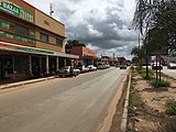 The Great North Road (T2) in Kabwe, just east of its intersection with Buntungwa Street
 -
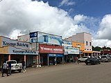 Buntungwa Street, Kabwe, near intersection with the Great North Road (T2)
 -
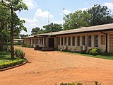 Classroom building at the Kabwe Town Campus of Mulungushi University
 -
 Aerial view of the Mulungushi Rock of Authority, birthplace of the Zambian independence movement
 -


References
- ^ "Kabwe (District, Zambia) – Population Statistics, Charts, Map and Location". www.citypopulation.de. Retrieved 2020-05-30.
- ^ a b c Kachingwe, Kelvin. "Kabwe: the nucleus of national politics". Times of Zambia. Archived from the original on 2006-10-12. Retrieved 8 March 2007.
- ^ "Kabwe | Zambia". Encyclopedia Britannica. Retrieved 2020-05-30.
- ^ a b Boyd, David R (2022). Sacrifice zones 50 of the Most Polluted Places on Earth (PDF). Special Rapporteur on Human Rights and the Environment.
- ^ a b Phir, Adrian (2015-08-25). Tackling urban flooding in a 'shanty' settlement Action at the Frontline, Kabwe, Zambia (PDF) (Report).
- ^ The Blacksmith Institute website accessed 1 March 2007.
- .
- ^ University, Hokkaido. "The lasting effects of pollution from the Kabwe mine". phys.org. Retrieved 2022-05-11.
- ISSN 0883-2927.
- ^ a b Gbadamosi, Nosmot (8 February 2023). "Zambia Takes Anglo American to Court". Foreign Policy. Retrieved 9 February 2023.
- ^ "Roads and Road Traffic Act | National Assembly of Zambia". www.parliament.gov.zm. Retrieved 2022-06-27.
- ^ "Dozens killed in Zambia as bus crashes into truck". The Guardian. 7 February 2013. Retrieved 7 February 2013.
- ^ "53 dead in Zambia bus-truck crash". New Zimbabwe. AFP. Archived from the original on 9 February 2013. Retrieved 7 February 2013.
- ^ a b c Zamnet Online News: Archived 2007-10-23 at the Wayback Machine "Kabwe: From discovery to recovery" (Zambia Daily Mail), website accessed 7 March 2007.
- ^ Bruce Kapferer: "Strategy and Transaction in an African Factory", Manchester: Manchester University Press 1972
- ^ "World Meteorological Organization Climate Normals for 1991-2020 — Kabwe". National Oceanic and Atmospheric Administration. Retrieved January 23, 2024.
- ^ "Kabwe MET Climate Normals 1961–1990". National Oceanic and Atmospheric Administration. Retrieved January 22, 2014.
External links
 Kabwe travel guide from Wikivoyage
- http://www.daily-mail.co.zm/the-rebirth-of-kabwe-town/
- http://www.bmrplc.com/kabwe_mine.php
- https://www.investincentralzambia.com/wordpress/kabwe-district-profile/
- https://www.mindat.org/loc-4341.htm
- https://www.zambia-info.org/country/town/1316/kabwe
14°26′S 28°27′E / 14.433°S 28.450°E
Largest cities or towns in Zambia According to the 2010 Census[1] | |||||||||||||||||||||||||||||||||||||||||||||||||||||||||||||||||||||||||||||||||||||||||||||
|---|---|---|---|---|---|---|---|---|---|---|---|---|---|---|---|---|---|---|---|---|---|---|---|---|---|---|---|---|---|---|---|---|---|---|---|---|---|---|---|---|---|---|---|---|---|---|---|---|---|---|---|---|---|---|---|---|---|---|---|---|---|---|---|---|---|---|---|---|---|---|---|---|---|---|---|---|---|---|---|---|---|---|---|---|---|---|---|---|---|---|---|---|---|
| |||||||||||||||||||||||||||||||||||||||||||||||||||||||||||||||||||||||||||||||||||||||||||||


| International | |
|---|---|
| National | |