
Kadrina Parish
You can help expand this article with text translated from the corresponding article in Estonian. (August 2023) Click [show] for important translation instructions.
|
Kadrina Parish
Kadrina vald | |
|---|---|
.JPG) Countryside near Kadapiku | |
 Flag  Coat of arms | |
 Kadrina Parish within Lääne-Viru County. | |
| Country | |
| County | |
| Administrative centre | Kadrina |
| Government | |
| • Mayor | Ain Suurkaev |
| Area | |
| • Total | 329.26 km2 (127.13 sq mi) |
| Population (2004) | |
| • Total | 5,156 |
| • Density | 16/km2 (41/sq mi) |
| ISO 3166 code | EE-272 |
| Website | www.kadrina.ee |
Kadrina Parish (Estonian: Kadrina vald) is a rural municipality in Lääne-Viru County, northern Estonia.[1] It covers an area of 329.26 km² (10% of the total area of the county) and has a population of 5,156 (as of January 1, 2004). The parish has had its current borders since 2005, when Saksi Parish was dissolved and Kiku, Pariisi and Salda villages were merged to Kadrina Parish, the larger part of Saksi Parish was added to Tapa Parish.
The administrative centre is the small borough (alevik) of Kadrina, which has a population of 2,600. Other major populated places are the small borough of Hulja (600 inhabitants) and the villages of Kihlevere (200 inhabitants), Vohnja (200 inhabitants) and Viitna (100 inhabitants). There are 32 villages in total.
The northern border of the municipality is also the southern border of Lahemaa National Park.
The
Settlements
- Small boroughs
- Villages
Ama, Arbavere, Hõbeda, Härjadi, Jõepere, Jõetaguse, Jürimõisa, Kadapiku, Kallukse, Kihlevere, Kiku, Kolu, Kõrveküla, Lante, Leikude, Loobu, Läsna, Mõndavere, Mäo, Neeruti, Ohepalu, Orutaguse, Pariisi, Põima, Ridaküla, Rõmeda, Salda, Saukse, Sootaguse, Tirbiku, Tokolopi, Udriku, Uku, Undla, Vaiatu, Vandu, Viitna, Vohnja, Võduvere, Võipere
Religion
Religion in Kadrina Parish (2021) [1]
Gallery
-
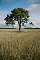 Kallukse pine
 -
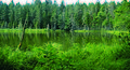 Nabudi lake
 -

-
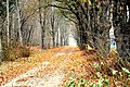 Kadrina railway station allee
 -
 Kadrina church
 -
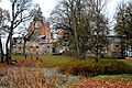 Neeruti manor
 -
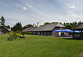 Viitna inn
 -
 Undla manor house
.jpg)
.jpg)
.jpg)


References
- ^ "X-GIS(4) Portal". xgis.maaamet.ee. Retrieved 31 January 2022.
External links
- Official website (in Estonian)
59°21′00″N 26°08′00″E / 59.35°N 26.133333°E
| Urban municipalities | ||
|---|---|---|
| Rural municipalities | ||