
Kaiser Mountains
| Kaiser Mountains (Kaisergebirge) | |
|---|---|
Tyrol | |
| Range coordinates | 47°33′42″N 12°18′7″E / 47.56167°N 12.30194°E |
| Parent range | Northern Limestone Alps |
| Official name | Wilder Kaiser |
| Designated | 8 April 2013 |
| Reference no. | 2146[1] |
The Kaiser Mountains
Divisions
The Kaiser Mountains are divided into the Wilder Kaiser or Wild Kaiser chain of mountains, formed predominantly of bare
.

Nature reserve
As early as the 1920s individual nature lovers, including the "Emperor Pope", Franz Nieberl, called for greater protection of the unique natural region of the Kaiser. The primary aim of this protection was to prevent over development of the Kaiser Mountains by cable cars and roads. In those days such ideas were unsuccessful. In 1961, following a referendum, it was decided to establish a nature reserve, which was officially opened on 19 April 1963. The reserve, which covered all the peaks of the Wilder and Zahmer Kaiser, has an area of 102 square kilometres (39 sq mi) and lies within the territories of the municipalities of Kufstein, St. Johann in Tirol, Ebbs, Ellmau, Going, Kirchdorf in Tirol, Scheffau and Walchsee. The height of the nature reserve's terrain ranges from 480 m up to 2344 m at the summit of the Ellmauer Halt. The only man-made lift in the protected area is the chair lift to the Brentenjoch saddle. Other lift projects were not realized because of the nature reserve. For a long time, the construction of a road into the Kaisertal valley was hotly contested as it was the only inhabited valley in Austria without road access. The Kaisertal road, which now runs from Ebbs through the Anna Tunnel (813 m long) into the Kaisertal, was opened on 31 May 2008. It was built by the parish of Ebbs as a private road for use only by a very narrow group of beneficiaries: residents, farmers, authorities and organisations with safety functions.
The
Geology and hydrology
The Kaiser is part of the
History
The first dated evidence of human settlement in the Kaiser Mountains goes back 4000 to 5000 years. These are discoveries of the remains of Stone Age hunters in the Tischofer Cave. Other discoveries have revealed the presence of Bronze Age settlers in the cave. Documentary evidence of human settlement in the Kaisertal in the Middle Ages date back at least to 1430. There is a purchase agreement from that year for a farm called Hinterkaiser. The name "Kaiser" for the area is older and already appears by 1240 in a Kitzbühel directory of goods which speaks of a Gamsgiayt an dem Chaiser. In 1611 there is an annotation to a picture in the maps of Matthias Burgklehner that states "There is in the dominion of Kufstein the Kayser, a very high mountain range, which is just like an imperial crown, on account of its many peaks, and also because it appears from an altitude and miles away as if it is round and crowned." (original: "Es ist in der Herrschaft Khueffstein der Kayser, ein sehr hoches Gepürg, so einer kaiserlichen Cron gleich ist, seiner vilfeltigen Zinggen halber, dann auch, dass er in der Heche vil Meils Wegs weit, als ob er rund und gekrönt ware, gesehen wird.")
The touristic development of the Kaiser began in the second half of the 19th century. Most of the documented first ascents of its summits date from that time until the turn of the century. It is likely, however, that most of the peaks had already been climbed from time to time by local herders and poachers, without any records having been kept. The time from the late 19th century to the First World War was a period when the limestone faces of the Wilder Kaiser were the cradle of Munich's climbing scene, when well-known climbing pioneers like Hans Dülfer developed entirely new climbing techniques and styles. Other well-known climbers from various periods who opened new routes on the Kaiser are Paul Preuss, Matthias Rebitsch, Hermann Buhl, and Alexander Huber.
The sometimes highly technology-centric climbing styles and techniques developed mainly before the First World War influenced climbing in the Kaiser until the 1960s. In 1977,
Important peaks and routes in the Wilder Kaiser

|
|
Gallery
-
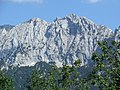 Wilder Kaiser, north side (Scheffauer)
 -
 Wilder Kaiser, south side
 -
 Wilder Kaiser, east side
 -
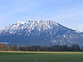 The Zahmer Kaiser seen from Oberaudorf


Important peaks in the Zahmer Kaiser

- Vordere Kesselschneid (2,002 m (6,568 ft))
- Pyramidenspitze (1,998 m (6,555 ft))
- Roßkaiser (1,970 m (6,460 ft))
- Elferkogel (1,916 m (6,286 ft))
- Jovenspitze (1,890 m (6,200 ft))
- Feldberg (1,814 m (5,951 ft))
- Stripsenkopf (1,807 m (5,928 ft))
- Petersköpfl (1,745 m (5,725 ft))
- Naunspitze (1,633 m (5,358 ft))
Neighbouring mountain groups
.svg)
The Kaiser borders on the following other mountain groups in the Alps:
- Chiemgau Alps (to the north)
- Loferer Steinberge(to the east)
- Kitzbühel Alps (to the south)
- Rofan(to the southwest)
- Bavarian Pre-Alps(to the northwest)
Mountain huts
- Private huts: Berghaus Aschenbrenner, Weinbergerhaus, Wochenbrunner Alm
Valley settlements
See also
References
- ^ "Wilder Kaiser". Ramsar Sites Information Service. Retrieved 25 April 2018.
- ISBN 978-1-85284-497-4.
- ^ Henshall, Mark (ed.) (2011). Frommer's Austria, 14th ed., John Wiley & Sons, Chichester.
- ^ von Zittel, Karl Alfred (1962). History of geology and palaeontology J. Cramer.
- ISBN 978-1-7802-2553-1.
- ^ Baring-Gould, Sabine (1911). The land of Teck and its neighborhood, John Lane.
- ^ The Kaiser Mountains at SummitPost.org
- ISBN 1-85284-261-X.
Literature
- Schubert, Pit (2000). (ISBN 3-7633-1272-2.
- Höfler, Horst and Piepenstock, Jan (2006). (ISBN 3-7633-1257-9.
- Stadler, Markus (2009). Kletterführer Wilder Kaiser, Vol 1 (Niveau 3-6). Panico-Alpinverlag, 3rd ed. ISBN 3-936740-06-2.
- Stadler, Markus (2004). Kletterführer Wilder Kaiser, Vol 2 (Niveau 6-10). Panico-Alpinverlag, 1st ed. ISBN 3-936740-13-5.
- Stadler, Markus, Strauß Andrea and Andreas (2009). Bildband Kaisergebirge. Bergverlag Rother, 1st ed. ISBN 978-3-7633-7050-4.
.JPG)
| International | |
|---|---|
| National | |