
Kalahari Desert
| Kalahari Desert | |
|---|---|
 A satellite image of the Kalahari by NASA WorldWind | |
 Kalahari Desert (maroon) Kalahari Basin (orange) | |
| Length | 4,000 km (2,500 mi) |
| Area | 900,000 km2 (350,000 sq mi) |
| Geography | |
| Countries | |
| State/Province | Southern Region |
| Coordinates | 23°S 22°E / 23°S 22°E |
| River | Orange River |
The Kalahari Desert is a large semi-arid sandy savanna in Southern Africa extending for 900,000 square kilometres (350,000 sq mi), covering much of Botswana, as well as parts of Namibia and South Africa.
It is not to be confused with the Angolan, Namibian, and South African Namib coastal desert, whose name is of Khoekhoegowab origin and means "vast place".
Etymology
Kalahari is derived from the Tswana word Kgala, meaning "the great thirst", or Kgalagadi, meaning "a waterless place";[1] the Kalahari has vast areas covered by red sand without any permanent surface water.
History
This section needs expansion. You can help by adding to it. (April 2021) |
The Kalahari Desert was not always a dry desert. The fossil flora and fauna from Gcwihaba Cave in Botswana indicates that the region was much wetter and cooler at least from 30 to 11 thousand BP (before present), especially after 17,500 BP.[2]
Geography
This section needs additional citations for verification. (February 2019) |


Drainage of the desert is by dry black valleys, seasonally inundated pans, and the large salt pans of the Makgadikgadi Pan in Botswana and Etosha Pan in Namibia. The only permanent river, the Okavango, flows into a delta in the northwest, forming marshes that are rich in wildlife. Ancient dry riverbeds—called omuramba—traverse the central northern reaches of the Kalahari and provide standing pools of water during the rainy season.
A semi-desert, with huge tracts of excellent grazing after good rains, the Kalahari supports more animals and plants than a true desert, such as the
Numerous pans exist within the Kalahari, including the Groot-vloer Pan and Verneukpan, where evidence of a wetter climate exists in the form of former contouring for capturing water. This and other pans, as well as river bottoms, were written about extensively at Sciforums by an article by Walter Wagner regarding the extensive formerly wet areas of the Kalahari. The Kalahari is extensive and extends farther north, where abandoned extensive roadways also exist.[3][unreliable source?]
Climate
The climate is sub-humid rather than semi-arid in the north and east, where the dry forests, savannahs, and salt lakes prevail. South and west, where the vegetation is predominantly xeric savanna or even a semi-desert, the climate is "Kalaharian"

The dry season lasts eight months or more, and the wet season typically from less than one month to four months, depending on location. The southwestern Kalahari is the driest area, particularly a small region toward the west-southwest of Tsaraxaibis (Southeast of Namibia). The average annual rainfall ranges from around 110 mm (close to aridity) to more than 500 mm in some north and east areas. During summertime in all regions, rainfall may go with heavy thunderstorms. In the driest and sunniest parts of the Kalahari, over 4,000 hours of sunshine are recorded annually on average.
In the Kalahari, there are three main mechanisms of atmospheric circulation, dominated by the Kalahari High anticyclone[6] in winter, and by the Kalahari Heat Low in summer:[7]
- The North and Northwest of the Kalahari are subject to the alternation "Intertropical Convergence Zone (ITCZ)/"Continental Trade winds". The ITCZ is the meeting area of the boreal trade winds with their austral counterparts what meteorologists call "Meteorological equator" and the sailors "Doldrum" or "Pot-au-noir" : the ITCZ generates rains in the wet season, whereas the continental trade winds cause the dry season;
- The rest of the Kalahari is subject to the maritime trade winds that largely shed their moisture as they cross up and over the Southern African Great Escarpment before arriving over the Kalahari.
- In the southern hemisphere summer (from December to February), a low-pressure system develops over the Kalahari, which is driven by strong surface heating (known as a Thermal Low). The low-pressure system helps to control the moisture-bearing easterly wind emanating from the Indian Ocean,[8] thus influencing rainfall across southern Africa.[9]
There are huge subterranean water reserves beneath parts of the Kalahari; the Dragon's Breath Cave, for example, is the largest documented non-subglacial underground lake. Such reserves may partly be the residues of ancient lakes; the Kalahari Desert was once a much wetter place. The ancient Lake Makgadikgadi dominated the area, covering the Makgadikgadi Pan and surrounding areas, but it drained or dried out some 10,000 years ago. It may have once covered as much as 120,000 square kilometres (46,000 sq mi).[10] In ancient times, there was sufficient moisture for farming, with dikes and dams collecting the water. These are now filled with sediment, breached, or no longer in use, though they can be readily seen via Google Earth.[11]
The Kalahari has had a complex climatic history over the past million or so years, in line with major global changes. Changes in the last 250,000 years have been reconstructed from various data sources, providing evidence of former extensive lakes and drier periods. During the latter, the area of the Kalahari has expanded to include parts of western Zimbabwe, Zambia, and Angola.[12]
Vegetation and flora
,_Kalahari.jpg)
.jpg)
Due to its low aridity, the Kalahari supports a variety of flora. The native flora includes
Even where the Kalahari "desert" is dry enough to qualify as a
In an area of about 600,000 km2 in the south and west of the Kalahari, the vegetation is mainly
In certain areas where the climate is drier, it becomes a true
Outside the Kalahari "desert", but in the Kalahari basin, halophytic vegetation to the north is adapted to pans, lakes that are completely dry during the dry season, and maybe for years during droughts, such as in Etosha (
A totally different vegetation is adapted to the perennial fresh water of the Okavango Delta, an ecoregion termed Zambezian flooded grasslands AT0907.[16]
Fauna
The Kalahari is home to many migratory birds and animals. Previously havens for wild animals from
Although there are few endemic species, a wide variety of species are found in the region, including large predators such as the
Some of the areas within the Kalahari are seasonal
The biggest threat to wildlife are the fences erected to manage herds of grazing cattle, which also removes the plant cover of the savanna itself. Cattle ranchers will also poison or hunt down predators from the rangeland, particularly targeting jackals and wild dogs.[citation needed]
-
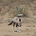 Oryx gazella
 -
 A meerkat in the Kalahari
 -
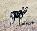 The endangered African wild dog in Central Kalahari Game Reserve


Protected areas
The following protected areas were established in the Kalahari:
Population
.jpg)
The San people have lived in the Kalahari for 20,000 years as hunter-gatherers.[19] They hunt wild game with bows and poison arrows and gather edible plants, such as berries, melons and nuts, as well as insects. The San get most of their water requirements from plant roots and desert melons found on or under the desert floor. They often store water in the blown-out shells of ostrich eggs. The San live in huts built from local materials—the frame is made of branches, and the roof is thatched with long grass. Most of their hunting and gathering techniques replicate pre-historic tribes. Bantu-speaking Tswana, Kgalagadi, and Herero and a small number of European settlers also live in the Kalahari desert. The city of Windhoek is situated in the Kalahari Basin.
Kalahari, San and diamonds
In 1996,
Settlements within the Kalahari
|
Botswana |
Namibia |
South Africa
|
See also
- Karoo
- Kgalagadi (disambiguation)
- Thar desert
- Sahara
- Hot deserts
- Climate change in Namibia
References
- ^ a b "The Kalahari-Basin". 15 July 2010. Archived from the original on 25 July 2015.
- .
- ^ "Ancient Namibian Freeway overlays Ancient Agriculture System". www.sciforums.com.
- ISBN 9782200251970, page 20 in particular.
- ^ "World Record Temperatures -Highest Lowest Hottest Coldest temperatures-". www.mherrera.org.
- ^ (in French) Tropicalité Jean Demangeot Géographie physique intertropicale, pages 44–45, Figure 19, source: Leroux 1989.
- ^ P. D. Tyson FRSSAf & S. J. Crimp (1998) THE CLIMATE OF THE KALAHARI TRANSECT, Transactions of the Royal Society of South Africa, 53:2, 93-112, DOI: 10.1080/00359199809520380
- ^ P. D. Tyson FRSSAf & S. J. Crimp (1998) THE CLIMATE OF THE KALAHARI TRANSECT, Transactions of the Royal Society of South Africa, 53:2, 93-112, DOI: 10.1080/00359199809520380
- ISBN 978-0-19-022862-0.
- ^ Goudie, Andrew (2002). Great Warm Deserts of the World: Landscapes and Evolution. Oxford University Press. p. 204.
- ^ "Ancient Dikes, Dams and Reservoirs of the Kalahari Region". www.sciforums.com.
- ^ Thomas, D.S.G. and Shaw, P.A. 1991 'The Kalahari Environment'. Cambridge University Press, Cambridge
- ^ Martin Leipold, Plants of the Kalahari
- ^ "How to Eat a Kiwano (Horned Melon)". wikiHow.
- .
- ^ a b c "Deserts and xeric shrublands - Biomes - WWF". World Wildlife Fund. Archived from the original on 15 March 2018. Retrieved 25 April 2013.
- ^ "Kalahari xeric savanna - Ecoregions - WWF". World Wildlife Fund.
- ^ Hogan, C. Michael (2008). Makgadikgadi, Megalithic Portal, ed. A. Burnham.
- ^ Marshall, Leon (16 April 2003), "Bushmen Driven From Ancestral Lands in Botswana", National Geographic News, Johannesburg, archived from the original on 24 October 2005, retrieved 22 April 2009
- ^ Workman, James (2009). Heart of Dryness. Walker Publishing. p. 323.
- ^ "UN report condemns Botswana's treatment of Bushmen". Survival for Tribal Peoples. 3 March 2010. Retrieved 31 March 2013.
Further reading
- Main, Michael (1987). Kalahari : life's variety in dune and delta. ISBN 1868120015.
External links
 Media related to Kalahari at Wikimedia Commons
- "Cry of the Kalahari"
- Kalahari desert's forgotten influence on carbon levels