
Karşıyaka
Karşıyaka | |
|---|---|
District and municipality | |
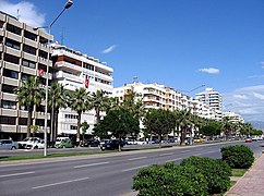
 Kemal Paşa Street (Çarşı), seen from the top of the Karşıyaka pier | |
 Map showing Karşıyaka District in İzmir Province | |
 Karşıyaka Location in Turkey  Karşıyaka Karşıyaka (İzmir) | |
| Coordinates: 38°27′34″N 27°06′55″E / 38.45944°N 27.11528°E | |
| Country | Turkey |
| Province | İzmir |
| Government | |
| • Mayor | Behice Yıldız Ünsal (CHP) |
| Area | 51 km2 (20 sq mi) |
| Population (2022)[1] | 346,264 |
| • Density | 6,800/km2 (18,000/sq mi) |
| Time zone | UTC+3 (TRT) |
| Area code | 0232 |
| Website | www |
Karşıyaka (pronounced
Geology
Late created formations around Izmir consist of sandstone, shale and limestone blocks some of which may be larger than several kilometers. Such formations which are generally observed on hills around the region, are the main reasons for resistance on the hills. In addition to these, the community of neogen age can easily be estimated through the andesitic compounds of volcanic origin, around Mount Yamanlar. Such units can be listed as silicon, aluminum, sodium, lava with magnesium content, tuff and tuff stuffed lava agglomerates. The lava also contains reddish brown and greenish gray large feldspar crystals. Neogen sedimentary rocks are made up of clay stone, sandstone and pebble stones at dept while being made up only of limestone on the top. At some places clay stone is observed on limestone layers. It is possible to say that ground resistance is satisfactory in regions covered with limestone on top, while ground resistance is low in regions which has thin layers of limestone intercalated with mud rocks.
Climate and environment
Karşıyaka bears the general characteristics of the
Location
The industrial zone bringing together principally firms of local-scale, exception made of the notable presence of Alaybey shipyard are located in the eastern part of Karşıyaka. The same eastern corner also covers a zone of sparse settlement around the locality called Soğukkuyu, originally a seaside village of semi-nomadic Turkmens (
Sport
Economy
Karşıyaka is deeply associated with commerce, construction of residences, education and literature, and is a prized area for pensioners, not only in the scale of İzmir but also from across Turkey as a whole. A total of 220,000 residences make up the urban area and the average yearly increase of the district population is 2.3 per cent. The district area having been almost entirely built up, Karşıyaka today acts principally as a residential centre for the workforce of İzmir's industry and services, who generally commute for work to neighbouring Çiğli and Bornova, Alsancak across the gulf, or even to locations further afield like Kemalpaşa and Manisa. The share of agriculture and industry in its economy is in constant decrease, while Karşıyaka's tourism potential remains an open field.
The waterfront is the wealthier part of Karşıyaka and it is here that residents of long date are generally concentrated. The neighbourhoods located along the slopes are poorer, with
History and sights of interest
Traces of the earliest phases of the timeline of İzmir, such as "The Tomb of Tantalus" and "Old Smyrna" are located at a stone's throw from Karşıyaka, in the very recently constituted metropolitan district of Bayraklı, which was formerly within the boundaries of the district of Karşıyaka.

Karşıyaka was described in frequent terms of admiration by travellers who visited İzmir, and they could not help but mention in detail the dense forests of Mount Yamanlar, reaching as far as the coast, and the gardens and orchards which garnish the shoreline and along the beds of its four streams, namely Ahırkuyu, Serinkuyu, Laka and Bornova.[

Still very leafy and lush generally despite intensive construction of medium- to

In pace with its resort-like atmosphere, Karşıyaka saw a number of Ottoman konaks or Levantine mansions erected within its boundaries, especially along the shoreline and serving as secondary residence. Luxury multi-storey residences at immediate seaside quickly rose next to modest inner quartiers around the train station where the working class was concentrated and the Turkish village of Soğukkuyu [5] The commuting movements and the way of life of İzmir's inhabitants were profoundly changed since then with Karşıyaka becoming part of the urban fabric.
By the time of the 1891 census, Karşıyaka had already acquired the appearance of a large township with 832 houses and a permanent population of 1080. A sizable Turkish population settled in Karşıyaka's Soğukkuyu some time before that date and that area is still distinguished by its rustic houses in the middle of the urban zone. In the meantime, the former village of Papa Scala or Papazkale or Papazköyü or Papaz İskelesi (Priest's quay) to the west came to be known as Bostanlı, in reference to
The four most important reminders of the Levantine heritage still intact in Karşıyaka are the Alliotti, Penetti, Van Der Zee, and Löhner houses. The first was built by a prominent Levantine family of
There is also a 1904-built
There are also more modest but still lovely little houses, characterised by their engaged front doors and narrow lines, termed as "
Karşıyaka is also where
Atatürk's feelings and words about Karşıyaka: İzmir‘in Karşıyakalıları ... Sizi derin muhabbetle selamlarım ... Ben bütün İzmir’i ve bütün İzmirlileri severim. Güzel İzmir’in temiz kalpli insanlarının da beni sevdiklerine eminim. Yanlız bir rastlantı beni Karşıyaka’ya daha fazla bağlamıştır. Karşıyakalılar, annem sinenizde, sizin topraklarınızda yatıyor. Karşıyakalılar, İzmir’i gördüğüm gün öncelikle Karşıyaka’yı ve orada sizin Türk topraklarınızda yatan anamın mezarını gördüm.
Administration
Karşıyaka is a stronghold of the social-democrats. Currently, the municipality is administered by Behice Yıldız Ünsal of the CHP (Republican People's Party).
Composition
There are 27
International relations
Karşıyaka is
Gallery
-
 Osman Bey Park in Karşıyaka
 -
 Typical residential buildings of the Karşıyaka neighbourhood
 -
 Buildings in Mavişehir from Bostanlı shore
 -
 Mavişehir shore


See also
- İzmir
- Karşıyaka SK
- Pınar Karşıyaka
- Karşıyaka Arena
- Levantine mansions of İzmir
External links
Resources
- "Karşıyaka, 39p" (PDF) (in Turkish). İzmir Chamber of Commerce. 2007.
Footnotes
- ^ TÜİK. Retrieved 12 July 2023.
- ^ Büyükşehir İlçe Belediyesi, Turkey Civil Administration Departments Inventory. Retrieved 12 July 2023.
- ^ "İl ve İlçe Yüz ölçümleri". General Directorate of Mapping. Retrieved 12 July 2023.
- ^ N. Ezgi Türken. "Investigation of Water Conveyance Systems of Historical Settlements in the north of the Aegean Region from hydraulic and hydrological point opf view" (PDF). Dokuz Eylül University, İzmir (unpublished master thesis). Archived from the original (PDF) on September 29, 2007. Retrieved 2006-04-01. (in English)
- ISBN 978-90-429-1675-3.
- tree fruits, such as melons and watermelons
- ^ "Neler Yapabilirsiniz - T.C. Karşıyaka Belediyesi - Resmi Web Sitesi". www.karsiyaka.bel.tr. Retrieved 2022-10-26.
- ISBN 9786052989890.
- ^ Mahalle, Turkey Civil Administration Departments Inventory. Retrieved 12 July 2023.