Karelian Isthmus

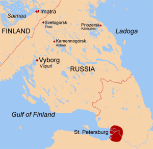
The Karelian Isthmus (
The smaller part of the isthmus to the southeast of the old Russia-Finland border is considered historically as Northern
According to the
Geography and wildlife


The isthmus' terrain has been influenced dramatically by the Weichselian glaciation. Its highest point lies on the Lembolovo Heights moraine at about 205 m (670 ft). There are no mountains on the isthmus, but steep hills occur in some places.
The
The Karelian Isthmus lies within the
The isthmus is mostly covered by
Pine forests (with
1184 species of wild
The climate of the isthmus is moderately continental, with 650–800 mm (25–32 in) average precipitation per year, long snowy winters lasting from November through mid-April and occasionally reaching about -40 °C (-40 F), moderately cool summers and short frost-free period. Compared to other parts of the Leningrad Oblast, the winter here is usually milder due to the moderating influence of the Gulf of Finland, but longer.
The city of Vyborg and the town of Priozersk are situated on the northwestern part of the isthmus.
The Karelian Isthmus is a popular place for
A 20–35 km wide stretch of land in
Geological history
Geologically the Karelian Isthmus lies on the southern edge of the Baltic Shield's crystalline bedrock. During the final part of the last Weichselian glaciation, deglaciation in the central parts of the Isthmus started as early as 14000 BP, when it formed the bottom of a large lake dammed by the surrounding ice sheet. During further deglaciation, at the time of the Baltic Ice Lake, an early high water stage of the Baltic Sea, when the ice sheet retreated to Salpausselkä, the upland area of the Isthmus remained a large island and many upland lakes emerged.[8]
Prior to 12650 BP, the land was characterized by harsh
Around 9000 BP
The connection disappeared due to ongoing land uplift in the 2nd millennium AD.In 1818 a canal, which was dug to drain spring flood waters from
Cities, towns and urban-type settlements

- Kamennogorsk (Finnish: Antrea)
- Kuznechnoye (Kaarlahti)
- Lesogorsky (Jääski)
- Primorsk (Koivisto)
- Priozersk (Käkisalmi)
- Roshchino (Raivola)
- Saint Petersburg (Pietari)
- Sertolovo (Sierattala)
- Sestroretsk (Siestarjoki)
- Sovetsky (Johannes)
- Svetogorsk (Enso)
- Toksovo (Toksova)
- Vsevolozhsk (Seuloskoi)
- Vyborg (Viipuri)
- Vysotsk (Uuras)
- Zelenogorsk (Terijoki).
Administrative territorial division
The Karelian Isthmus is located in two regions of the
| District | Region |
|---|---|
| District of Vyborg | Lenoblast |
| District of Priozersk | Lenoblast |
| District of Vsevolozhsk | Lenoblast |
| Kurortny District | SPB |
| Primorsky District | SPB |
| Vyborgsky District | SPB |
| Kalininsky District | SPB |
| Krasnogvardeysky District | SPB |
| Nevsky District | SPB |
History
Archaeology

Apart from the old towns of
Prehistory and Medieval
Ancestors of
In the 11th century,
17th–20th centuries
During 17th century Sweden gained the whole isthmus and also Ingria. In this time many Karelians escaped to Tver's Karelia.
From 1721–1917 the isthmus belonged to the
Due to its size, favorable climate, rich fishing waters and proximity to

When Finland declared its independence in 1917, the isthmus (except for the territory roughly corresponding to present-day
World War II


A number of defensive lines crossed the isthmus during the Soviet-Finnish hostilities in
In November 1939, the

In 1941, during
On 9 June 1944, strong Soviet forces opened the
After the war

As a result of the war, the population of the Karelian Isthmus was almost completely replaced. After the war the isthmus was included in the Leningrad Oblast and people from other parts of the Soviet Union, mostly Russians, were settled there. The vast majority of the old Finnish toponyms in the conquered territories were renamed to invented Russian ones by the government around 1948.[19] The Finnish toponyms of the territories included within Karelo-Finnish SSR and of the southern part of the isthmus (albeit assimilated) mostly remained. A lot of youth summer camps were built all over the isthmus during the time of the Soviet Union. Some of them still exist.
Transport
The only
Saimaa Canal (opened in 1856) is an important link connecting inland waterways of Finland with the Gulf of Finland.
The Karelian Isthmus is served by a number of railways; the trains arrive from
- Saint Petersburg-Hiitola railroad
- eastern part of the Saint Petersburg-Riihimäki railroad
- Saint Petersburg – Sestroretsk – Beloostrov
- southern part of the Vyborg-Joensuu railroad
- Saint Petersburg – Vsevolozhsk – Ladozhskoye Ozero
- Petrokrepost– Nevskaya Dubrovka
- Veschevo (earlier also through Zhitkovo to Michurinskoye)
- Kamennogorsk – Svetogorsk – Imatra
- Zelenogorsk – Primorsk – Sovetsky – Vyborg
Also on the Karelian isthmus are all lines of the St.
Industry
The
Vyborg Shipyard is one of the largest
In
Military
The Karelian Isthmus is included within
Population
The population of the Karelian isthmus today is slightly less than 3.1 million inhabitants. Of these, about 2.4 million live in St. Petersburg and a little less than 700 thousand in the Leningrad region. The population is growing solely due to migration, as the mortality rate is much higher than the birth rate, but the migration attractiveness of St. Petersburg and the surrounding areas of the Leningrad region is very high. Thus, about 40% of the population of St. Petersburg and about 30% of the population of the Leningrad region live on the Karelian isthmus. There is strong growth in population in all the districts of the Karelian isthmus in addition to the Vyborg district and Priozersk district .
Notable people from the isthmus
Finnish period

HEIGHTS
- Martti Ahtisaari, Finnish president, and recipient of the 2008 Nobel Peace Prize
- Georg Elfvengren, Finnish military commander
- Gustav Hägglund, Finnish military commander
- Max Jakobson, Finnish diplomat
- Gustaf Komppa, Finnish chemist
- Juho Niukkanen, Finnish politician
- Karl Lennart Oesch, Finnish military commander
- Larin Paraske, Finnish oral poet
- Swedish-speaking Finnishpoet.
- Lauri Törni, born in Viipuri, Törni was a soldier and winner of the Mannerheim Cross during the Continuation War, who later served with the German and American armies.
- Uno Ullberg, Finnish architect
- Johannes Virolainen, Finnish politician
- Artturi Ilmari Virtanen, Finnish chemist, and recipient of the 1945 Nobel Prize in Chemistry
Soviet and post soviet period
- Elena Pogrebizhskaya
- Ilia Shtokalov
- Nastasya Samburskaya
- Lyubov Kozyreva (cross-country skier)
- Elena Kondulainen
References
- ^ Location is approximately between 61°21’N, 59°46’N and 27°42’E, 31°08’E.
- ^ "Karjalankannas" (in Finnish). Karjalan Liitto. Retrieved January 30, 2022.
- ^ "Karjalankannas" (in Finnish). Prima Tours. Retrieved January 30, 2022.
- ^ Karelian Isthmus Archived 2007-12-06 at the Wayback Machine
- ISBN 978-5-87317-384-6.
- ^ Доронина, Анна. Флористическиe исследования на Карельском перешейке Archived 2007-09-29 at the Wayback Machine
- ^ See maps: [1] (in Russian)
- ^ a b Davydova, Natalia N. et al. (1996). Late- and postglacial history of lakes of the Karelian Isthmus. Hydrobiologia 322.1-3, 199–204.
- ^ Subetto, Dmitry A. et al. (2002). Climate and environment on the Karelian Isthmus, northwestern Russia, 13000–9000 cal. yrs BP. Boreas 31.1, 1–19.
- ^ Saarnisto, Matti & Tuulikki Grönlund (1996). Shoreline displacement of Lake Ladoga – new data from Kilpolansaari. Hydrobiologia 322.1-3, 205–215.
- ^ Timofeev, V. I. et al. (2005). Evolution of the Waterways and Early Human Migrations in the North-Eastern Baltic Area. Geochronometria 24, 81–85.
- ISBN 5-87403-052-2
- ^ Лебедев Г. С. Археологические памятники Ленинградской области. Ленинград: Лениздат, 1977.
- Archaeology, Ethnology and Anthropology of Eurasia26.2, 35–44.
- ^ Kurs, Ott (1994). Ingria: The broken landbridge between Estonia and Finland. GeoJournal 33.1, 107–113.
- ISBN 0-333-80149-0
- ISBN 0-7146-4314-9.
- ^ "Protocol appended to the treaty of peace". heninen.net.
- ^ a b Степаков, Виктор, Евгений Балашов. В «Новых районах»: Из истории освоения Карельского перешейка, 1940–1941, 1944–1950 Archived 2007-09-28 at the Wayback Machine. Saint Petersburg: Нордмедиздат, 2001.
- ^ Малков, Виктор (2006). Потенциал недр Archived 2007-09-28 at the Wayback Machine. Промышленно-строительное обозрение 93.
Further reading
- Балашов Е. А. Карельский перешеек: Земля неизведанная. Юго-западный сектор, часть 1: Кивеннапа – Териоки (Первомайское – Зеленогорск). СПб.: Новое время, 1998. ISBN 5-93045-016-1.
- Балашов Е. А. Карельский перешеек: Земля неизведанная. Юго-западный сектор, часть 2: Уусикиркко (Поляны). СПб.: Новое время, 2000. ISBN 5-87517-022-0.
- Балашов Е. А. Карельский перешеек: Земля неизведанная. Юго-западный сектор, часть 3: Каннельярви – Куолемаярви (Победа – Пионерское). СПб.: Новое время, 1998. ISBN 5-93045-017-X.
- Балашов Е. А. Карельский перешеек: Земля неизведанная. Часть 2–3. Юго-западный сектор: Уусикиркко – Куолемаярви – Каннельярви (Поляны – Красная Долина – Победа). 2-е изд., перераб. и доп. СПб.: Нива, 2002. ISBN 5-86456-124-X.
- Шитов Д.И. Карельский перешеек: Земля неизведанная. Часть 4. Восточный сектор: Рауту – Саккола (Сосново – Громово). СПб.: Нордмед-Издат, 2000. ISBN 5-93114-040-9.
- Балашов Е. А. Карельский перешеек: Земля неизведанная. Часть 5. Западный сектор: Койвисто (Приморск). СПб.: КультИнформПресс, 2002. ISBN 5-8392-0216-9.
- Балашов Е. А. Карельский перешеек: Земля неизведанная. Часть 5 – 6. Западный сектор: Койвисто – Йоханнес (Приморск – Советский). 2-е изд., испр. и доп. СПб.: Нива, 2003. ISBN 5-86456-102-9.
- Орехов Д.И., Балашов Е. А. Карельский перешеек: Земля неизведанная. Часть 7. Центральный сектор: Муолаа – Яюряпяя (Красносельское – Барышево). СПб.: Нива, 2004. ISBN 5-86456-078-2.
- Орехов Д.И., Балашов Е. А. Карельский перешеек: Земля неизведанная. Часть 8. Восточный сектор: Метсяпиртти (Запорожское). СПб.: Нива, 2005. ISBN 5-86456-116-9.
- Балашов Е. А. Карельский перешеек: Земля неизведанная. Часть 9. Центральный сектор: Валкъярви – Вуоксела (Мичуринское – Ромашки). СПб.: Нива, 2005. ISBN 5-86456-065-0.
- Шитов Д.И. Карельский перешеек: Земля неизведанная. Часть 10. Северо-восточный сектор: Ряйсяля (Мельниково). СПб., 2006. ISBN 5-86456-118-5.
- Иллюстрированный определитель растений Карельского перешейка / Под ред. А. Л. Буданцева, Г. П. Яковлева. – СПб: СпецЛит, 2000.
External links
- Detailed and historical maps (site navigation in Russian)
- Site of the local history association "Karelia" (in Russian).
- Terijoki.spb.ru (in Russian)
