Karpuzlu
Karpuzlu | |
|---|---|
District and municipality | |
 | |
 Map showing Karpuzlu District in Aydın Province | |
| Coordinates: 37°33′33″N 27°50′04″E / 37.55917°N 27.83444°E | |
| Country | Turkey |
| Province | Aydın |
| Government | |
| • Mayor | Hilmi Dönmez (MHP) |
| Area | 286 km2 (110 sq mi) |
| Population (2022)[1] | 10,590 |
| • Density | 37/km2 (96/sq mi) |
| Time zone | UTC+3 (TRT) |
| Postal code | 09540 |
| Area code | 0256 |
| Website | www |
Karpuzlu (Turkish: [kaɾˈpuzɫu]) is a municipality and district of Aydın Province, Turkey.[2] Its area is 286 km2,[3] and its population is 10,590 (2022).[1] It is 56 km (35 mi) from the city of Aydın. It became a district centre after separation from Çine in 1990.
Karpuzlu is reached by turning off the road from
Alinda
.
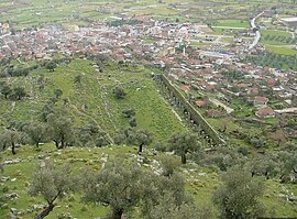
The town is partially situated on the slopes of a hill on the top of which can be seen the well-preserved ruins of the ancient acropolis of
Alinda
.
The modern district of Karpuzlu covers part of the
Menderes River
(Maeander) valley. The main crops are cotton, corn and many other grains and vegetables.
Karpuzlu (former Demircidere) itself is a very small town of 2,300 people.
Composition
There are 23
neighbourhoods in Karpuzlu District:[4]
See also
- Alinda
- Gülkız Ürbül
References
- ^ TÜİK. Retrieved 12 July 2023.
- ^ Büyükşehir İlçe Belediyesi, Turkey Civil Administration Departments Inventory. Retrieved 12 July 2023.
- ^ "İl ve İlçe Yüz ölçümleri". General Directorate of Mapping. Retrieved 12 July 2023.
- ^ Mahalle, Turkey Civil Administration Departments Inventory. Retrieved 12 July 2023.


