
Kastellorizo
Kastellorizo
Castellorizo Καστελλόριζο Μεγíστη | |
|---|---|
Clockwise from the top: Port of Kastellorizo, Lady of Ro Tomb in Ro Islet, Castello Rosso along with Kastellorizo Archaeological Museum, Lady of Ro Statue, view of the town of Kastellorizo, Lycian Tomb, Fokiale Cave | |
|
UTC+3 (EEST) | |
| Postal code | 851 11 |
| Area code(s) | 22460 |
| Vehicle registration | ΚΧ, ΡΟ, ΡΚ |
| Website | www.kastellorizo.online |


Kastellorizo or Castellorizo (
The island has become very popular in recent years among tourists looking for an isolated place in the Dodecanese, thanks also to the 1991 Oscar-winning movie Mediterraneo, by Gabriele Salvatores, which is set on the island during the Second World War.
Name and etymology
The island's official name, Megisti (Μεγίστη) means "biggest" or "greatest", but at only 11.98 km2 (4.626 sq mi) in area, it is the smallest of the Dodecanese. The name refers to the fact that it is the largest of the small archipelago.[3] This name was used in antiquity,[6] but is now rarely used in Greek, the name Kastellórizo (Καστελλόριζο) being common since the 12th century. There are several hypotheses about the origin of this name.[7] "Kastello" derives from the Italian word "castello", meaning "castle".[7] There is some argument on the second part of the name. The arguments are centered on the following possible origins of the element rizo:
- rizo being derived from the Italian word "rosso" meaning "red", either from the reddish color of the rocks of the island, the reddish color of the castle at sunset,Knights of Rhodes, Juan Fernández de Heredia, which stood above the gate of the castle; these arguments are widely discredited as the rocks on the island have no red pigment and the name Kastellorizo predates the Knights' arrival.[3]
- rizo being a corruption of the word "Rhoge", one of the ancient appellations of the nearby island of Ro. If this is correct, the island's modern name is actually an amalgam of the separate island names "Castello" and "Rhoge".
- rizo being the actual Greek word "rizon" meaning "root", as researched by Greek Historian I.M. Hatzifotis (1996), to signify the foothill or 'rizovouno' on which the island's original castle was built.[7]
It has gone by several different names in its history, including Kastellorizo (Greek),, the former deriving from the island's official name in Greek, the latter meaning "Red Castle", a translation of the Italian name.
Physical geography

Kastellorizo is (with the exception of the nearby islet of
Nearby islands between Turkey and Kastellorizo
There are many islets in this area; Volos, near
All these islets were subject to dispute between
The group of islands that includes Kastellorizo, Ro and Strongyli is very important to the Exclusive economic zone of Greece, since it is the easternmost territory of Greece and according to UNCLOS as well as customary international law, Greece can claim a large part of the Eastern Mediterranean basin.
-
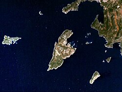 Satellite picture of the island
 -
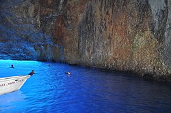 The Blue Cave
 -
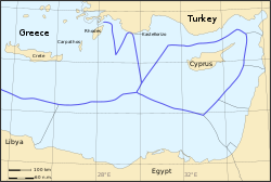 Kastellorizo within the EEZ of Greece


Geography


The houses of the town are slender and characterised by wooden balconies and windows of the Anatolian type.[14] Behind the waterfront, many houses are still in a ruinous state. At the entrance to the harbour, on the east side, stand the single-story remnants of the former Italian government house (palazzina della delegazione), erected in 1926 by the Italian architect Florestano Di Fausto, who also designed some of the most important buildings of the Italian period in Rhodes.[15] Nearby is the island's former Ottoman mosque which dates from the second half of the 18th century and which has been restored and re-opened as a museum since 2007. From here starts the town's quay, which runs along all three sides of the harbour. The central square — Plateia Ethelondon Kastellórizou ("Kastellorizo Volunteers' Square") — lies at the midpoint of the eastern side, near the vessel dock. On the opposite side of the harbour one has a good view from this vantage of Pera Meria, the western quay, and the monasteries of Profitis Ilías and Aghia Triadha, the former now an army base.
Above the quay on the eastern side is a pathway which leads to the Castle of the Knights (14th century). Of it remain the curtain wall, part of a square tower, the remains of a cylindrical tower at the east corner, and toward the sea another cylindrical tower.[13] A Doric inscription, carved in the rock, attests to the existence of an earlier fortress here during Antiquity.[13] Inside the tower there is a large covered cistern.[13]
Ascending the steps on the eastern side of the town, one reaches the suburb of Horafia, where there is a square surrounded by the Church of St. George (1906), with a high dome of Byzantine type, and the Cathedral of Saints Constantine and Helena (1835). It has three naves divided by monolithic granite columns from the temple of Apollo Lykios in Patara (Anatolia).[14] The columns carry ogival arches. Further east is the small bay known as Mandraki, the secondary harbour of the island.
West of the town, beyond the summit of the island known as Vigla (270 m), stands Palaiokastro (old castle), the island's ancient acropolis. This fortified elevation has classical origins (see below, history section): its plan is rectangular and measures 60 by 80 metres (200 ft × 260 ft).[13] In its interior stand an ancient tower, built with square limestone blocks, and large water cisterns.[13] Carved on the base of the castle there is also a Doric inscription, dating back to the 4th or 3rd centuries BC, with references to Megiste (the ancient name of Kastellorizo) and its dependence on Rhodes.[13] On the east side there are remnants of a gateway, or propylaea.[13]
Since August 2020 the island also features an interactive Puzzle Museum, the first of its kind in Greece and one of the very few in the world.[citation needed]
Climate
Kastellorizo has a
| Climate data for Kastellorizo 5 m a.s.l. | |||||||||||||
|---|---|---|---|---|---|---|---|---|---|---|---|---|---|
| Month | Jan | Feb | Mar | Apr | May | Jun | Jul | Aug | Sep | Oct | Nov | Dec | Year |
| Record high °C (°F) | 20.6 (69.1) |
22.3 (72.1) |
26.1 (79.0) |
29.6 (85.3) |
34.8 (94.6) |
37.4 (99.3) |
40.8 (105.4) |
40.1 (104.2) |
36.6 (97.9) |
37.4 (99.3) |
27.7 (81.9) |
23.2 (73.8) |
40.8 (105.4) |
| Mean daily maximum °C (°F) | 16.6 (61.9) |
17.1 (62.8) |
18.4 (65.1) |
21.3 (70.3) |
26.2 (79.2) |
29.2 (84.6) |
34.1 (93.4) |
33.7 (92.7) |
31.2 (88.2) |
27.3 (81.1) |
23.0 (73.4) |
18.8 (65.8) |
24.7 (76.5) |
| Daily mean °C (°F) | 14.4 (57.9) |
14.7 (58.5) |
15.6 (60.1) |
18.2 (64.8) |
22.6 (72.7) |
25.6 (78.1) |
29.9 (85.8) |
30.2 (86.4) |
28.2 (82.8) |
24.5 (76.1) |
20.5 (68.9) |
16.6 (61.9) |
21.8 (71.2) |
| Mean daily minimum °C (°F) | 12.1 (53.8) |
12.3 (54.1) |
12.8 (55.0) |
15.1 (59.2) |
18.9 (66.0) |
22.0 (71.6) |
25.8 (78.4) |
26.7 (80.1) |
25.2 (77.4) |
21.6 (70.9) |
18.0 (64.4) |
14.4 (57.9) |
18.7 (65.7) |
| Record low °C (°F) | 4.5 (40.1) |
5.5 (41.9) |
5.2 (41.4) |
10.7 (51.3) |
15.2 (59.4) |
17.8 (64.0) |
22.9 (73.2) |
24.7 (76.5) |
21.6 (70.9) |
15.8 (60.4) |
12.9 (55.2) |
9.1 (48.4) |
4.5 (40.1) |
| Average rainfall mm (inches) | 140.6 (5.54) |
50.2 (1.98) |
45.2 (1.78) |
17.5 (0.69) |
4.5 (0.18) |
8.9 (0.35) |
0.1 (0.00) |
0.0 (0.0) |
1.2 (0.05) |
26.3 (1.04) |
92.9 (3.66) |
150.9 (5.94) |
538.3 (21.21) |
| Source 1: National Observatory of Athens Monthly Bulletins (Sep 2018 – Mar 2024)[18] | |||||||||||||
| Source 2: Kastellorizo N.O.A station[19] and World Meteorological Organization[20] | |||||||||||||
Geology
The island's

History
Ancient period
The island was colonised by
The three towers of Kastellorizo, Ro and Strongyli comprise the main links in a dense network of watchtowers constructed by the Rhodians during the Hellenistic period, to control the sea routes and the coast. Palaiokastro was (and still is) the main and largest fortified site on the island.[24]

Byzantine era
During the period of the
Knights Hospitaller period
In 1306 the island was taken over by the
Ottoman era
The Crown of Aragon retained possession of it until 1512, when it was conquered by Ottoman Sultan Suleiman I.[3]
On 22 September 1659, during the Siege of Candia, the island was conquered by Venice and the castle was destroyed again, but the Ottomans were able to regain it again soon after.[3] Between 1828 and 1833 Kastellórizo joined the Greek insurgents, but after the end of the Greek War of Independence it came back into the possession of the Ottoman Empire.[3]
According to the Ottoman General Census of 1881/82-1893, the kaza of Kastellorizo (Meyis) had a total population of 4,871, consisting of 4,635 Greeks, 225 Muslims, 6 Jews and 5 foreign citizens.[26]
In 1912, during the
World War I and French presence
On 28 December 1915, during
Italian period
In the
Because of the Italian occupation, the island was not affected directly by the Population exchange between Greece and Turkey of 1923, but the forced emigration of the large Greek population living on the nearby Anatolian coast hit heavily the economy of the island.

The
Modern Greek era
Kastellorizo was assigned to Greece with the Paris Peace Treaties, 1947. In May 1945 it was still under British administration, but on September 15, 1947 effectively came under Greek administration. The island formally joined the Greek State on 7 March 1948 together with the other Dodecanese islands.
The island has become more popular in recent years, among tourists looking for an isolated place in the Dodecanese, thanks also to the 1991 Oscar-winning movie
In 2011, the French ship Dignité-Al Karama, the only member the Freedom Flotilla II that managed to approach Gaza, refueled at Kastellorizo. The ship was warmly received by the inhabitants, some of whom remembered the shelter the island's inhabitants had found in Gaza, then under British control, during World War II.[27]
Demographics and economy

The population rose from 4,870 in the 1880s and reached its peak in 1908 with an estimated 9,000 people residing there. At that time, Kastellorizo was still the only safe harbor along the route between Makri (today's
After 1908, the decay of the island's economy set in, accelerated by the decline of the Ottoman Empire and the population exchange between Greece and Turkey in 1923. In the late 1920s the island's population dropped to 3,000, while about 8,000 inhabitants lived abroad, predominantly in Australia, Egypt, Greece and the U.S.[15] At that time the town had 730 inhabited houses, while 675 were already empty, and many ruined.[15]
The population continued to drop to 584 at the 1951 census, reaching a low point of 222 at the 1981 census, before slowly rising again to 584 at the 2021 census, all living in the town of Megísti. The municipality also includes the islands of
The existence of a Muslim community on the island during the Ottoman period can be deduced from the presence of a mosque with a minaret that still exists but by 1929 was no longer functioning.[14]
Transport
The island is connected with Rhodes, Piraeus and Kaş by ferry. Passenger ferries' frequency is as follows:
- Kastellorizo - Rhodes - Symi - Tilos - Nisyros - Kalymnos - Piraeus: 2 trips / week (winter period)[28]
- Kastellorizo - Kaş: 1 trip / week (winter period)[29]
Air connection is provided by
Culture
Kastellorizo's inhabitants had characteristic traditions, partly influenced by the Muslim tradition.[31] There were at least three types of women's dress, which used brilliantly colored fabric, and women wore necklaces, brooches, pendants and earrings made from ancient Venetian or Byzantine gold coins.[15]
The women's festive dress consisted of:
- One or more long
- A pair of short pants (katofóri) whose lower part was made with good quality material quilted with gold thread;[15]
- A sleeved jacket (zepuni) made with brilliant colored silk or velvet, opened at the front;[15]
- Another long underskirt (kavadi), laced with gold thread, also opened at the front;
- A large scarf (zosma) made with three or four silk strips, quilted with gold or silver thread. It was tied very low on the sides, like a loose belt;[15]
- A large velvet
- A woolen cap;[15]
- A quadrangular wrinkled silken shawl (mandili), decorated with relief flowers and fringed hems, coloured in white, red and deep blue. Folded diagonally, it was fixed above the cap, with its longest angle falling on the back almost to the ground, while the side edges were folded on the front or put over the shoulders;[15]
- The
- The
The other types of dress were similar, but not so lavish and without fur decorations.[15] The girls' dress was simpler. Single and engaged girls, and married women and widows were also distinguished by dress.[15]
Religion, customs and superstitions
The
On December 31 and on New Year's Day, groups of children carrying small cardboard boats adorned with ribbons and small flags go around visiting houses, stores and coffee shops, singing songs with good wishes and receiving coins and wheat cakes, while the elderly exchange visits.[14] On the morning of Agios Basilios day, coming back from Liturgy, the men customarily throw a pomegranate hard against the walls of their homes, wishing for abundance and happiness for their family. The more seeds that are spread around the rooms, the more luck the family will have in the coming year.[14]
The day before the feast of Agios Elias on July 19 (the feast itself is on July 20) first the children and then the men jump into the sea, and wear their wet clothes the whole day. Those who do not want to participate are sometimes forced to do so.[14][32]
On
On May 1, at dawn, all the girls of the island, in groups, each one carrying a jar, went to get water outside of town, but they were not allowed to speak a single word during the route. This water (Amilito Neró, "water of silence") was supposed to bring good luck to the family. Everyone washed him/herself with it that day, and every utensil and wall of the house was splashed with it. When a girl became engaged, she filled a crystal carafe with it and brought it to her future mother-in-law, who gave her in return a special cake and an odd number of gold coins.[14]
When a child became seriously ill, a woman with knowledge of prayers against the evil eye was invited to her/his home. She drew signs of the cross on the body of the child with a thurible filled with embers and branches of the olive tree which had been gathered in the church on Palm Sunday, pronouncing the following words: "Christ came: then he laid down his stick and chased away the snake and the bad neighbor from our home". After this exorcism, the woman would throw the content of the thurible into a bucket filled with water, and then count the pieces of wood which did not burn. This number was said to be equal to the number of persons who were supposed to have enchanted the sick child. The enchantment of the child was sure, if the olive leaves burned with a loud crackling sound.[14]
When a man was going to emigrate, gentle, sorrowful songs were sung to him by his friends.[14]
Notable people
- Georgios Mavros, politician
- Andrew Liveris, businessman
- Nicholas Paspalis, pearl diver and creator of Paspaley pearling company
- Ken Michael, former Governor of Western Australia
- Mayor of Perth
- Steve Malaxos, Australian rules footballer
- Lady of Ro, patriot
Twin towns – sister cities
Kastellorizo is
- Perth, Western Australia, Australia
 Antalya, Turkey
Cinema and popular culture
In the 1961 film The Guns of Navarone, a saboteur team led by Anthony Quayle is briefed on its mission at Castelrosso. The Italian 1991 movie Mediterraneo was filmed on the island.
Kastellorizo also lends its name to David Gilmour's instrumental track "Castellorizon" from his album On an Island (2006). He stayed on the island in the early 1990s with his wife, Polly Samson, and many close friends. The music reflects the memories of the time spent there, and is a tribute to the friends who have since died.[citation needed]
See also
- Meis–Kaş Swim
References
- ^ "Αποτελέσματα Απογραφής Πληθυσμού - Κατοικιών 2021, Μόνιμος Πληθυσμός κατά οικισμό" [Results of the 2021 Population - Housing Census, Permanent population by settlement] (in Greek). Hellenic Statistical Authority. 29 March 2024.
- ^ "Kastellórizon". Merriam-Webster.com Dictionary. Retrieved 4 August 2019.
- ^ a b c d e f g h i j k l Bertarelli, 131
- ^ "Limits of Oceans and Seas, 3rd edition" (PDF). International Hydrographic Organization. 1953. p. 18. Archived from the original (PDF) on 8 October 2011. Retrieved 28 December 2020.
- ^ "ΦΕΚ A 87/2010, Kallikratis reform law text" (in Greek). Government Gazette.
- ^ Strabo, Geographica 14.3.7 [1]
- ^ a b c d Stampolidis, Nicholas & others (2011). Islands off the beaten track. An archeological journey to the Greek islands of Kastellorizo, Simi, Halki, Tylos and Nisyros. Athens: Museum of Cycladic Art. p. 28.
- ^ a b c d "Nísos Megísti". gr.geoview.info. Retrieved 26 November 2021.
- ^ Marinescu, Constantin (1994). La politique orientale d'Alfonse V d'Aragon, roi de Naples (1416-1458) (in French). Barcelona: Institut d'Estudis Catalans. p. 203., (online)
- ^ "Kızılhisar Adası Nerede Ve Nasıl Gidilir?". www.hurriyet.com.tr (in Turkish). 22 February 2021. Retrieved 26 November 2021.
- ^ Pilarinos, George (2020-07-08). "Kastelorizo island – Things to Do and Best Places to Visit". GREtour.
- ^ "Population & housing census 2001 (incl. area and average elevation)" (PDF) (in Greek). National Statistical Service of Greece. Archived from the original (PDF) on 2015-09-21.
- ^ a b c d e f g h Bertarelli, 134
- ^ a b c d e f g h i j k l m Bertarelli, 133
- ^ a b c d e f g h i j k l m n o p q r s t u v Bertarelli, 132
- ^ Μηνιαίο Δελτίο Μετεωρολογικών Παραμέτρων Ελλάδα (in Greek) Retrieved 11 March 2023
- ^ "Meteo.gr – Προγνώσεις καιρού για όλη την Ελλάδα".
- ^ "Meteo.gr - Προγνώσεις καιρού για όλη την Ελλάδα".
- ^ "Latest Conditions in Kastellorizo".
- ^ "World Meteorological Organization". Retrieved 14 July 2023.
- ^ Smith, William (1865), Dictionary of Greek and Roman geography, s.v. "Megiste".
- ^ "Strabo, Geography, BOOK XIV., CHAPTER III". www.perseus.tufts.edu. Retrieved 11 March 2023.
- ^ "Pseudo Scylax, Periplous, §100" (PDF). Retrieved 11 March 2023.
- ^ Centre, UNESCO World Heritage. "Ancient Towers of the Aegean Sea". UNESCO World Heritage Centre.
- ISBN 0-299-06670-3.
- The University of Wisconsin Press, p. 130-131
- ^ a b "Gaza-bound ship carrying pro-Palestinian activists sets sail from Greece". Haaretz. Retrieved 17 July 2011.
- ^ "Blue Star Ferries - Piraeus - Kalymnos - Kos - Rhodes & Astypalaia - Patmos - Lipsi - Leros - Nisyros - Tilos - Symi - Kastellorizo". Archived from the original on 2016-04-11. Retrieved 2016-01-06.
- ^ "Ferry Kas to Meis - Meis Express Ferry Service with Aegean Tour Travel". ferries-turkey.com. Archived from the original on 2011-06-02.
- ^ https://e-ticket.olympicair.com/pl/A3Online/wds/FlexPricerAvailability.action;jsessionid=QkUW9l5IS4t7GVZx1q7j4KDd5w-5AfHTKGO55jOHLSJTUeYa8Cwg!384344890!-982618842 [dead link]
- ^ Gerola, Giuseppe. "Castelrosso". Enciclopedia Italiana (1931 edition). Treccani. Retrieved 21 January 2014.
- ^ M. Hamilton, "The Pagan Element in the Names of Saints", The Annual of the British School at Athens 13 (1906–07) 348–55, pp. 353–54.
Sources
- Bertarelli, L.V. (1929). Guida d'Italia, Vol. XVII (in Italian). Milano: Consociazione Turistica Italiana.
- Hatzifotis, I.M. (1996). Kastellorizon. Athens: Topio Publications.
- Köchler, Hans (2020). Kastellorizo: The Geopolitics of Maritime Boundaries and the Dysfunctionality of the Law of the Sea. Vienna: International Progress Organization.
- Pappas, Nicholas (1994). Castellorizo: An Illustrated History of the Island and its Conquerors. Sydney: Halstead Press.
- Pappas, Nicholas (2002). Near Eastern Dreams: The French Occupation of Castellorizo 1915–1921. Sydney: Halstead Press.
- The Princeton Encyclopedia of Classical Sites, Megiste.
| Regional unit of Andros |  | |
|---|---|---|
| Regional unit of Kalymnos | ||
| Regional unit of Karpathos-Kasos | ||
| Regional unit of Kea-Kythnos | ||
| Regional unit of Kos | ||
| Regional unit of Milos | ||
| Regional unit of Mykonos | ||
| Regional unit of Naxos | ||
| Regional unit of Paros | ||
| Regional unit of Rhodes | ||
| Regional unit of Syros | ||
| Regional unit of Thira | ||
| Regional unit of Tinos | ||
| ||
| International | |
|---|---|
| National | |
| Geographic | |
| Other | |