Kathiawar
This article needs additional citations for verification. (March 2014) |
Kathiyawar
Saurashtra | |
|---|---|
UTC+5:30 (IST ) |
Kathiawar ([kɑʈʰijɑʋɑɽ]) is a peninsula, near the far north of India's west coast, of about 61,000 km2 (23,500 sq mi) bordering the Arabian Sea. It is bounded by the Gulf of Kutch in the northwest and by the Gulf of Khambhat in the east. In the northeast, it is connected to the rest of Gujarat and borders on the low, fertile hinterland of Ahmedabad. It is crossed by two belts of hill country and is drained radially by nine rivers which have little natural flow aside from in monsoon months, thus dams have been built on some of these. Kathiawar ports have been flourishing centres of trade and commerce since at least the 16th century.[1]
Etymology and history
The name Kathiawad seems to have been derived from the early settlements of Kathikas or Kathis who entered Gujarat from Sindh in early centuries of the Common Era.[2][3]
History

Kathis were spread out in the entire region and dominated central
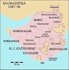
In a geopolitical context, the area of Kathiawar forms the core of Saurashtra. In feudal times, there were certain principal divisions in Saurashtra that fell under princely states:
For a long time, the name Sorath remained limited to the region when the Chudasama
Literary comment


The state of the region in the early nineteenth century is shown in Letitia Elizabeth Landon's poetical illustration, "Scene in Kattiawar", to an engraving of a painting by Clarkson Frederick Stanfield.[6]
Political history

Before Indian independence in 1947, most of Kathiawar was divided into numerous
After Indian independence, the states of Kathiawar acceded to India under the Instrument of Accession. In 1947, Junagadh's Muslim ruler acceded his territory to Pakistan. The predominantly Hindu population rebelled, and while the prince fled to Pakistan, a referendum was conducted that merged the kingdom into the Indian Union. The former princely states of Kathiawar were grouped into the new province of Saurashtra, which became the state of Saurashtra in 1950. In 1956, Saurashtra was merged into Bombay State, and in 1960, Bombay state was divided along linguistic lines into the new states of Gujarat (including Kathiawar) and Maharashtra. Diu was under Portuguese rule until it was occupied by Indian troops by 1961. It integrated into India as part of the union territory of Goa, Daman and Diu in 1962.
Major cities
Surendranagar and the historic city Wadhwan in the central portion of Gujarat, Dwarka on the west coast, and the historic city of Junagadh in the South. Diu, an island town formerly part of Portuguese India and now part of the Indian union territory of Dadra and Nagar Haveli and Daman and Diu, lies off the south coast of Kathiawar. The city of Somnath and its temple are also located on the south coast.
Districts in Kathiawad RegionGeography and ecosystemUnion Territory of Dadra and Nagar Haveli and Daman and Diu.)  The natural vegetation on most of the peninsula is xeric scrub. A range of low hills known as the Gir Hills occupies the south-central portion of the peninsula. The highest of these is Girnar. The hills are home to an enclave of tropical dry broadleaf forest.[7]
Gir National Park and its surroundings host the last remaining Asiatic lion population.[8][9] Other national parks in Kathiawar are Blackbuck National Park, Velavadar on the Gulf of Cambay, and Marine National Park, Gulf of Kutch, near Jamnagar.[citation needed] Antiquity (places: history, archaeology, nature, religion)  
Notable characters and figures
Religion, pre-history, spirituality
Society, ideology, politics, leadership
Governance, nobility, reforms, politics
Art, literature, poetry, journalism, socialism
Sports, adventure
Cinema, entertainment, music, folklore
Business, industry, innovation, entrepreneurship, philanthropy
History and culture
See also
References
External links |

