
Mount Kazbek
| Mount Kazbek | |
|---|---|
 Mount Kazbek | |
| Highest point | |
| Elevation | 5,054 m (16,581 ft)[1][2] |
| Prominence | 2,353 m (7,720 ft)[1] |
| Isolation | 113.6 km (70.6 mi) |
| Listing | Ultra |
| Coordinates | 42°41′57″N 44°31′06″E / 42.69917°N 44.51833°E[1] |
| Naming | |
| Native name |
|
| Geography | |
 Kazbegi Location of Mount Kazbegi within the Caucasus Mountains  Kazbegi Kazbegi (Mtskheta-Mtianeti) | |
| Location | |
| Countries | Russia and Georgia |
| Parent range | Lateral Range Caucasus |
| Geology | |
| Mountain type | Stratovolcano (dormant) |
| Last eruption | 750 BCE ± 50 years |
| Climbing | |
| First ascent | Yosif Buzurtanov (late 18th century)[4][5] |
| Easiest route | Basic snow/ice climb |
Mount Kazbek or Mount Kazbegi[a] is a dormant stratovolcano and one of the major mountains of the Caucasus, located in Georgia, just south of the border with Russia.[6]
Lying at 5,054 meters (16,581 ft) above at sea level, Mount Kazbek is the highest mountain in Eastern Georgia. It is also the third-highest peak in the country (after Mount Shkhara and Janga). Kazbegi is the second-highest volcanic summit in the Caucasus, after Mount Elbrus. The summit lies directly to the west of the town of Stepantsminda and is the most prominent geographic feature of the area.[6] The last eruption occurred c. 750 BCE.[6]
Origin of the name
The name Kazbeg is disputed; some claims are it is named after a Circassian nobleman who lived on it, other claims are it is named after local nobleman Dimitri Chopikashvili (grand father of the Georgian writer Aleksandre Kazbegi) got the title of "Kazbeg" from Georgian king Erekle II. The word "Kazbek" means a "nobleman" in Kabardian language. The title appeared under Georgian king Rostom in the 17th century. The name of the mountain in Georgian, Mqinvartsveri, translates to "Glacier Peak" or "Freezing Cold Peak".[7] The Ingush name Beshloam and Chechen name Bashlam translates as "Molten Mount".
Location
Kazbek is located on the
Owing to the steepness of its slopes, the glaciers of Kazbek are not very large.
From 24 to 28 May 2019 Caucasus Skitouring Network organized an expedition to survey Mt. Kazbegi's height. On 27 May 2019 at 12:22 GMT+4, for the first time, a survey team placed a GPS receiver on the Mt. Kazbegi peak. The new height is defined with the WGS 84 datum. Height was determinate with 5mm accuracy. Defined height is 5053.927m.[citation needed]
Legend
Mount Kazbegi is associated in Georgian folklore with
According to

Kazbegi nature reserve
The area around Mount Kazbegi was designated a nature reserve by the
Climate
| Climate data for Kazbek, 5034 m asl (1981–2010 normals) | |||||||||||||
|---|---|---|---|---|---|---|---|---|---|---|---|---|---|
| Month | Jan | Feb | Mar | Apr | May | Jun | Jul | Aug | Sep | Oct | Nov | Dec | Year |
| Record high °C (°F) | −1.5 (29.3) |
8.0 (46.4) |
2.0 (35.6) |
8.0 (46.4) |
7.8 (46.0) |
14.0 (57.2) |
20.0 (68.0) |
21.0 (69.8) |
15.0 (59.0) |
8.8 (47.8) |
14.7 (58.5) |
8.0 (46.4) |
21.0 (69.8) |
| Mean daily maximum °C (°F) | −10.9 (12.4) |
−9.0 (15.8) |
−7.3 (18.9) |
−3.3 (26.1) |
−0.2 (31.6) |
4.7 (40.5) |
6.9 (44.4) |
7.9 (46.2) |
4.4 (39.9) |
−0.6 (30.9) |
−2.8 (27.0) |
−6.9 (19.6) |
−1.4 (29.4) |
| Daily mean °C (°F) | −14.0 (6.8) |
−12.3 (9.9) |
−10.2 (13.6) |
−6.4 (20.5) |
−2.5 (27.5) |
1.7 (35.1) |
4.6 (40.3) |
5.5 (41.9) |
2.1 (35.8) |
−3.9 (25.0) |
−6.0 (21.2) |
−10.7 (12.7) |
−4.3 (24.2) |
| Mean daily minimum °C (°F) | −17.1 (1.2) |
−15.6 (3.9) |
−13.0 (8.6) |
−9.6 (14.7) |
−4.8 (23.4) |
−1.4 (29.5) |
2.3 (36.1) |
3.0 (37.4) |
−0.2 (31.6) |
−7.0 (19.4) |
−9.2 (15.4) |
−14.4 (6.1) |
−7.3 (18.9) |
| Record low °C (°F) | −24.9 (−12.8) |
−28 (−18) |
−28 (−18) |
−20.4 (−4.7) |
−11 (12) |
−11.2 (11.8) |
−4 (25) |
−5 (23) |
−14 (7) |
−16 (3) |
−18 (0) |
−27 (−17) |
−28 (−18) |
| Average precipitation mm (inches) | 88.0 (3.46) |
68.1 (2.68) |
56.8 (2.24) |
73.4 (2.89) |
123.3 (4.85) |
75.3 (2.96) |
96.9 (3.81) |
99.8 (3.93) |
65.5 (2.58) |
82.0 (3.23) |
107.0 (4.21) |
73.8 (2.91) |
1,009.9 (39.75) |
| Average precipitation days (≥ 1 mm) | 8.1 | 6.5 | 6.9 | 9.4 | 13.6 | 11.6 | 10.6 | 8.7 | 10.0 | 10.3 | 10.0 | 8.3 | 114 |
| Source 1: Météo climat stats[10] | |||||||||||||
| Source 2: Météo Climat [11] | |||||||||||||
See also
- List of highest points of Russian federal subjects
- List of volcanoes in Georgia (country)
Gallery
-
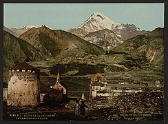 19th-century postcard of the Georgian Military Road near Mount Kazbegi
 -
 Mount Kazbek from the outside of the Gergeti Trinity Church
 -

-

-
 Crevasses of the Gergeti Glacier
 -
 Kazbegi Mountain, August 2019


_range,_Caucasus,_Georgia.jpg)


Notes
References
- ^ a b c "European Russia and the Caucasian States: Ultra-Prominence Page". peaklist.org. Retrieved 2014-05-25.
- ^ "Gora Kazbek, Georgia". Peakbagger.com. Retrieved 2015-05-25.
- ISBN 978-5-94849-423-4.
- ^ a b Арджеванидзе 1954, p. 227.
- ^ a b Дахкильгов 1989, p. 99.
- ^ a b c "Kazbek". Global Volcanism Program. Smithsonian Institution. Retrieved 2021-06-24.
- ^ "მყინვარი", Donald Rayfield et al., A Comprehensive Georgian-English Dictionary (2006)
- ^ a b c d This article incorporates text from a publication now in the public domain: Chisholm, Hugh, ed. (1911). "Kasbek". Encyclopædia Britannica. Vol. 15 (11th ed.). Cambridge University Press. p. 685.
- ISBN 962-217-748-4.
- ^ "Moyennes 1981-2010 Géorgie" (in French). Retrieved 11 November 2019.
- ^ "Météo Climat stats for Kazbek". Météo Climat. Retrieved 11 November 2019.
Sources
- Арджеванидзе, И.А. (1954). Военно-грузинская дорога: Краеведческий очерк с приложением схематической карты маршрута и библиографии [Georgian Military Road: Local history essay with the appendix of a schematic map of the route and bibliography] (in Russian). Tbilisi: Госиздат Грузинской ССР. pp. 1–250.
- Дахкильгов, Ш.Э. (1989). Слово о родном крае (Записки краеведа) [A word about the native land (Notes of a local historian)] (in Russian). ISBN 5-7666-0023-2.
External links
- "Mount Kazbek". Peakware.com. Archived from the original on 2016-03-04. – photos
- Normal climbing route to Mount Kazbek – detailed description
- Different ways to climb mt Kazbek – detailed description
| International | |
|---|---|
| National | |
| Geographic | |