
Kedarnath
This article may need to be rewritten to comply with Wikipedia's quality standards. (January 2024) |
Kedarnath
Kedarkhand | |
|---|---|
Town | |
UTC+5:30 (IST) | |
| PIN | 246445 |
| Vehicle registration | UK-13 |
| Website | badrinath-kedarnath |
Kedarnath is a town and
Etymology
The name "Kedarnath" means "the Lord of the Field". It is derived from the Sanskrit words kedara ("field") and natha ("lord"). The text Kashi Kedara Mahatmya states that it is so-called because "the crop of liberation" grows here.[5]
History
Kedarnath is a pilgrimage site or
According to the hagiographies based on Madhava's Sankshepa-Shankara-Vijaya, the 8th century philosopher
Location

Kedarnath is located at a distance of 223 km from
Demographics
As of the 2011 India census,[14] Kedarnath has a population of 830. Males constitute 99% of the population and females 1%.[15] Kedarnath has an average literacy rate of 63%: male literacy is 63%, and female literacy is 36%. Out of total population, 604 were engaged in work or business activity. Of this 601 were males while 3 were females.[15] In Kedarnath, none of the population is under six years of age. The floating population from May to October every year is more than 5000 per day with the pilgrim influx rising up to 10 lacs (1 million) in 2022.[16]
Climate
The Kedarnath Temple is closed during the winter months due to heavy snowfall. For six months, from November to April, the palanquin with the
| Climate data for Kedarnath, Uttarakhand | |||||||||||||
|---|---|---|---|---|---|---|---|---|---|---|---|---|---|
| Month | Jan | Feb | Mar | Apr | May | Jun | Jul | Aug | Sep | Oct | Nov | Dec | Year |
| Mean daily maximum °C (°F) | 1.0 (33.8) |
2.4 (36.3) |
6.0 (42.8) |
10.8 (51.4) |
14.8 (58.6) |
17.1 (62.8) |
16.5 (61.7) |
15.9 (60.6) |
14.3 (57.7) |
10.6 (51.1) |
6.9 (44.4) |
3.7 (38.7) |
10.0 (50.0) |
| Daily mean °C (°F) | −3.7 (25.3) |
−2.3 (27.9) |
1.2 (34.2) |
5.6 (42.1) |
9.3 (48.7) |
11.9 (53.4) |
12.3 (54.1) |
12.0 (53.6) |
9.8 (49.6) |
5.3 (41.5) |
1.6 (34.9) |
−1.4 (29.5) |
5.1 (41.2) |
| Mean daily minimum °C (°F) | −8.4 (16.9) |
−6.9 (19.6) |
−3.5 (25.7) |
0.5 (32.9) |
3.8 (38.8) |
6.8 (44.2) |
8.2 (46.8) |
8.1 (46.6) |
5.3 (41.5) |
0.1 (32.2) |
−3.6 (25.5) |
−6.5 (20.3) |
0.3 (32.6) |
| Average precipitation mm (inches) | 118.0 (4.65) |
101.0 (3.98) |
116.0 (4.57) |
63.0 (2.48) |
50.0 (1.97) |
75.0 (2.95) |
240.0 (9.45) |
234.0 (9.21) |
149.0 (5.87) |
57.0 (2.24) |
24.0 (0.94) |
51.0 (2.01) |
1,278 (50.32) |
| Source: [18] | |||||||||||||
2013 flash floods

On 16 June 2013, at approximately 7:30 P.M., a landslide occurred near the Kedarnath Temple. Water from the Chorabari Tal or Gandhi Tal down Mandakini River also washed away everything in its path at about 8:30 p.m. On 17 June 2013 at approximately 6:40 a.m., waters rushed down from Chorabari Tal or Gandhi Sarovar, bringing along with its flow, a huge amount of silt, rocks, and boulders. A huge boulder got stuck behind the Kedarnath Temple, protecting it from the ravages of the flood. The flood-water gushed on both sides of the temple, destroying everything in its path.[19][20] Thus in the middle of the pilgrimage season, torrential rains, cloud bursts, and resulting flash floods nearly destroyed the town of Kedarnath. The town was the worst affected area by the floods.[21] Thousands of people were killed, and thousands of others (mostly pilgrims) were reported missing or stranded due to landslides around Kedarnath. Although the surrounding area and compound of the Kedarnath Temple were destroyed, the temple itself survived.[22][23]
The rescue operation resulted in more than 100,000 people being airlifted with the help of mainly the Private Helicopter Operators, who began the rescue mission voluntarily without any clear directives from the State Government or the Ministry of Defence. The Indian Army and Indian Air Force helicopters arrived much after the Private Helicopter Operators had already begun the massive air-rescue mission. Dare-devil helicopter pilots, mostly ex-Indian Air Force and Ex-Army Aviation officers, flew relentlessly. Capt. Unni Krishnan from Prabhatam Aviation & Capt. Bhatnagar from Premair were few such outstanding pilots who landed at the Sh. Kedarnath Ji right-ridge at dusk hours - 1910hrs (almost 35 minutes after 'sunset') to pick-up the 'last' batch of survivors for the day. The NDRF represented by a commandant, and another junior officer arrived at the 'right-ridge' of the town bordering the Mandakini River, unprepared with a malfunctioning satellite phone. However, the next day, they brought in more men and supplies. The first Indian Army officer to arrive at the Sh. Kedarnath Ji 'right-ridge' was a Captain from the Assam Rifles Regiment. He single-handedly displayed exemplary courage in rescuing many survivors by climbing up steep slopes and fractures along the Rambara ridge-line. The Indian Army later launched a massive rescue effort with thousands of its brave-heart men and vital equipment. The Indo-Tibetan Border Police and the reserve battalions of the Uttarakhand Police displayed outstanding courage in the rescue mission. A Eurocopter AS350 B3 helicopter, each, of the private helicopter operators - Prabhatam Aviation & Simm Samm Aviation, were lost during the rescue mission without any reported casualties. An Indian Air Force helicopter (Mi 17) also crashed during this exercise, killing all 20 people on board (all of them were soldiers involved in relief and rescue work). The Air Force dropped logs to build pyres for mass cremations of the victims.[21] It was reported that previously uncollected bodies were still being found one year after the tragedy.[24]
Flood-proof infrastructure plan
After the floods, the Government of India decided to provide a flood-free infrastructure plan for the town. This involves:
- Development of the retaining wall and ghats on the Mandakini River
- Development of the retaining wall and ghats on the Sarasvati River
- Construction of the main approach to the Kedarnath Temple
- Development of the Adi Shankaracharya Kutir and Museum
- Development of houses for the Kedarnath Teerth Purohits
The foundation stone for the plan was laid by Prime Minister Narendra Modi on 20 October 2017.
Places of interest
Other than the Kedarnath Temple, on the eastern side of the town is Bhairavnath Temple,[12] and the deity of this temple, Bhairavnath, is believed to protect the town during the winter months. About 6 km upstream from the town, lies Chorabari Tal, a lake cum glacier also called Gandhi Sarovar.[12] Near Kedarnath, there is a cliff called Bhairav Jhamp.[12] Other places of interest include the Kedarnath Wildlife Sanctuary, Adi Shankaracharya Samadhi, and Rudra meditation cave.[25]
-
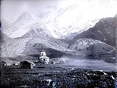 Kedarnath in the 1860s, with the temple being the prominent structure.
 -
 Lord Bhairavnath Ji considered as the Protector God of the area
 -
 The Kedarnath Temple in 2014, one year after the floods.
 -
 The Mandakini River on the bank of the town


See also

References
- ^ "Report of the Commissioner for linguistic minorities: 50th report (July 2012 to June 2013)" (PDF). Commissioner for Linguistic Minorities, Ministry of Minority Affairs, Government of India. Archived from the original (PDF) on 8 July 2016. Retrieved 7 December 2020.
- ^ Trivedi, Anupam (19 January 2010). "Sanskrit is second official language in Uttarakhand". Hindustan Times. Archived from the original on 1 February 2012. Retrieved 30 August 2017.
- ^ "Sanskrit second official language of Uttarakhand". The Hindu. 21 January 2010. Archived from the original on 3 March 2018. Retrieved 30 August 2017.
- ^ "Here is what happened in Kedarnath, and rest of Uttarakhand, in 2013". The Indian Express. Retrieved 7 December 2018.
- ISBN 978-0-307-83295-5.
- ^ Whitmore, Luke (2018). Mountain, Water, Rock, God: Understanding Kedarnath in the twenty-first century. University of California Press. pp. 1–7.
- ISBN 978-1-59884-204-3.
- ISBN 978-0-8239-3179-8.
- ISBN 978-90-04-30618-9.
- ISBN 978-0-7914-1282-4.
- ISBN 978-1-4381-0873-5.
- ^ ISBN 9781843530893.
- .
- ^ "Census of India 2011: Kedarnath". Census Commission of India. Retrieved 28 February 2022.
- ^ a b "Kedarnath Population Census 2011 - 2022". Consensus 2011.
- ^ "Pilgrim influx to Kedarnath Dham crosses 10.08 lakh, breaks all previous records". Hindustan Times. Retrieved 17 August 2022.
- ^ "Brahma Kamal: A source of Livelihood in the Life of Locals of Kedarnath Shrine". ResearchGate.
- ^ "KEDARNATH CLIMATE". CLIMATE-DATA.ORG. Retrieved 5 May 2020.
- ^ "[First-person Account] 'How I Survived 16 June Fury At Kedarnath' - Manoj Rawat - Tehelka - Investigations, Latest News, Politics, Analysis, Blogs, Culture, Photos, Videos, Podcasts". www.tehelka.com. Archived from the original on 29 October 2013. Retrieved 16 July 2013.
- ^ "Uttarakhand floods: Survivors of Kedarnath recount ordeal". Yahoo News. Retrieved 23 February 2021.
- ^ a b "High and wet". The Economist. 29 June 2013. Retrieved 14 November 2020.
- ^ "Monsoon fury leaves Kedarnath shrine submerged in mud and slush". The Indian Express. 19 June 2013. Retrieved 23 February 2021.
- ^ Mishra, Subhash (19 June 2013). "Thousands missing near Kedarnath shrine". The New Indian Express. Retrieved 23 February 2021.
- ^ Bhatt, Bindiya (12 June 2014). "Exclusive: Dead bodies of pilgrims found in Kedarnath, one year after Uttarakhand tragedy". News Nation English. Retrieved 23 February 2021.
- ^ "Kedarnath | Char Dham | Uttarakhand Tourism". namasteindiatrip.com. Retrieved 4 March 2022.
- Dictionary of Hindu Lore and Legend (ISBN 0-500-51088-1) by Anna Dhallapiccola
External links
- Official website
 Media related to Kedarnath at Wikimedia Commons
 Kedarnath travel guide from Wikivoyage
| Deities |  | ||||||||||
|---|---|---|---|---|---|---|---|---|---|---|---|
| Texts | |||||||||||
| Mantra/Stotra |
| ||||||||||
| Traditions | |||||||||||
| Festivals and observances | |||||||||||
Shiva temples |
| ||||||||||
| Related topics | |||||||||||