Kennemerland
This article needs additional citations for verification. (January 2021) |

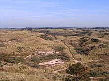
Kennemerland is a coastal region in the northwestern Netherlands, in the province of North Holland. It includes the sand dunes north of the North Sea Canal, as well as the dunes of Zuid-Kennemerland National Park.
History


Kennemerland gets its name from the Kennemer people,
Canninefates.[1]
Because of the wars and the Dutch rerouting of waterways, the original borders of Kennemerland have been lost. During the 20th century, the term Kennemerland has been redefined to denote municipal regions of North Holland. Because the Kennemers, according to folklore, were always on the attack, many sports teams in Haarlem are called Kennemers.
Precisely who the Kennemer people were is unclear. The knights of Kennemerlant, as the area was then called, quarrelled continually over trading rights and land ownership. The local farmers who paid rent were often asked for goods from either Egmond Abbey or their local church, as well as from these knights. In North Holland during the years 900–1300, castles were often built and later destroyed, and archaeologists today are still trying to piece together evidence.
Municipalities located in Kennemerland today

North Kennemerland
- Alkmaar (partly also in West Frisia)
- Dijk en Waard (the area of the former municipality of Heerhugowaard) (located completely in West Frisia)
- Bergen (including Egmond, former seat of the Counts of Holland)
- Castricum
- Heiloo
- Uitgeest
Middle Kennemerland (IJmond)
South Kennemerland
- Bloemendaal, with Thijsse's Hof (Garden of Thijsse), a wildlife garden with native plants of South Kennemerland.
- Haarlem (capital of North Holland)
- Haarlemmermeer
- Heemstede
- Zandvoort
See also

- Gijsbrecht van Aemstel (play)
- Zuid-Kennemerland National Park
- Godfrid, Duke of Frisia
- Floris V, Count of Holland
References
