Kent
Kent | |
|---|---|
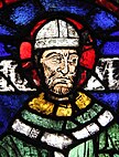
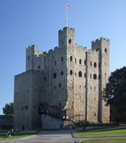
The White Cliffs of Dover, stained glass depicting Thomas Becket in Canterbury Cathedral, and Rochester Castle | |
| Coordinates: 51°12′N 0°42′E / 51.200°N 0.700°E | |
5th of 48 | |
| Density | 494/km2 (1,280/sq mi) |
| Ethnicity | 93.7% White (89.1% White British)[2] |
| Non-metropolitan county | |
| County council | Kent County Council |
| Executive | Conservative |
| Admin HQ | Maidstone |
| Area | 3,544 km2 (1,368 sq mi) |
| • Ranked | 6th of 21 |
| Population | 1,578,519 |
| • Ranked | 1st of 21 |
| Density | 445/km2 (1,150/sq mi) |
| ISO 3166-2 | GB-KEN |
| ONS code | 29 |
| GSS code | E10000016 |
| ITL | UKJ42 |
| Website | kent |
| Districts | |
 Districts of Kent Unitary County council area | |
| Districts | |
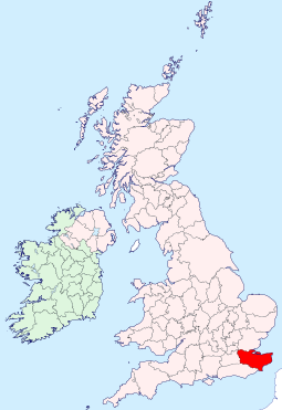
Kent is a county in the South East England region, the closest county to continental Europe. It borders Essex across the entire estuary of the River Thames to the north; the French department of Pas-de-Calais across the Strait of Dover to the south-east; East Sussex to the south-west; Surrey to the west and Greater London to the north-west. The county town is Maidstone.
It is the
Kent was one of the first British territories to be settled by Germanic tribes, most notably the Jutes, following the withdrawal of the Romans.[3] Canterbury Cathedral in Kent, the oldest cathedral in England, has been the seat of the Archbishops of Canterbury since the conversion of England to Christianity that began in the 6th century with Saint Augustine. Rochester Cathedral in Medway is England's second-oldest cathedral. Located between London and the Strait of Dover, which separates England from mainland Europe, Kent has been the setting for both conflict and diplomacy, including the Battle of Britain in World War II and the Leeds Castle peace talks of 1978 and 2004.
England relied on the county's ports to provide warships through much of its history; the Cinque Ports in the 10th[4]–14th centuries and Chatham Dockyard in the 16th–20th centuries were of particular importance. France can be seen clearly in fine weather from Folkestone and the White Cliffs of Dover. Hills in the form of the North Downs and the Greensand Ridge span the length of the county and in the Vale of Holmesdale in between and to the south are most of the county's 26 castles.
The county has agriculture, haulage, logistics and tourism industries. As the land between the capital and the wider continent, it is a high-income county. Agriculture of the county is a notable sector: "The Garden of England" is a nickname for the county, which has multiple orchards and allotments.[5] In north-west Kent, industries include aggregate building material extraction, printing and scientific research. Coal mining has also played its part in the county's industrial heritage.
Etymology

The name Kent is believed to be of Celtic origin. The meaning has been explained as 'coastal district,' 'corner-land' or 'land on the edge' (compare Welsh cant 'bordering of a circle, tyre, edge;' Breton cant 'circle;' Dutch kant 'side, edge'). In Latin sources the area is called Cantia or Cantium, while the Anglo-Saxons referred to it as Cent, Cent lond or Centrice.[6][7]
History
The area was first occupied by
Julius Caesar described the area as Cantium, or the home of the Cantiaci, in 51 BC.[9] The extreme west of the modern county was by the time of Roman Britain occupied by a Celtic Iron Age tribe known as the Regni. Caesar wrote that the people of Kent were 'by far the most civilised inhabitants of Britain'.[7]
Following the withdrawal of the Romans, large numbers of Germanic speakers from mainland Europe settled in Kent, bringing their language, which came to be Old English. While they expelled the native Romano-British population, some likely remained in the area, eventually assimilating with the newcomers.[10] Of the invading tribes, the Jutes were the most prominent, and the area became a Jutish kingdom[11] recorded as Cantia in about 730 and Cent in 835. The early medieval inhabitants of the county were referred to as the Cantwara, or Kentish people. The city of Canterbury was the largest in Kent.[12]
In 597,
Kent was traditionally partitioned into East and West Kent, and into lathes and hundreds. The traditional border of East and West Kent was the county's main river, the Medway. Men and women from east of the Medway are Men (or Maids) of Kent, those from the west are Kentishmen or Kentish Maids.[7] The divide has been explained by some as originating in the Anglo-Saxon migrations, with Jutes mainly settling east of the Medway and Saxons settling west of it.[15][16]
In the 11th century, the people of Kent (or Chenth, per the
During the medieval and early modern period, Kent played a major role in several of England's most notable rebellions, including the Peasants' Revolt of 1381, led by Wat Tyler,[18]

The

By the 17th century, tensions between Britain and the powers of the Netherlands and France led to increasing military build-up in the county. Forts were built all along the coast following the raid on the Medway, a successful attack by the Dutch navy on the shipyards of the Medway towns in 1667.[21]
The 18th century was dominated by wars with France, during which the Medway became the primary base for a fleet that could act along the Dutch and French coasts. When the theatre of operation moved to the
In the early 19th century, smugglers were very active on the Kent coastline. Gangs such as The Aldington Gang brought spirits, tobacco and salt to the county, and transported goods such as wool across the sea to France.[23]
In 1889, the
Originally, the border between Kent and Sussex (later East Sussex) ran through the towns of Tunbridge Wells and Lamberhurst. In 1894, by the Local Government Act, the parts of these towns that lay in East Sussex were absorbed by Kent.
During the Second World War, much of the Battle of Britain was fought in the skies over Kent.
Between June 1944 and March 1945, more than 10,000
After the war, Kent's borders changed several more times. In 1965, the London boroughs of
For almost nine centuries, a small part of present-day East London (the
Geography


Kent is in the southeastern corner of England. It borders the
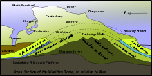
The major geographical features of the county are based on a series of ridges and valleys running east–west across the county. These are the results of
The Wealden dome is a
Seismic activity has occasionally been recorded in Kent, though the
The coastline of Kent is continuously changing, due to
Kent's principal river, the River Medway, rises near East Grinstead in Sussex and flows eastwards to Maidstone. Here it turns north and breaks through the North Downs at Rochester, then joins the estuary of the River Thames near Sheerness. The Medway is some 70 miles (112 km) long.[33][34] The river is tidal as far as Allington lock, but in earlier times, cargo-carrying vessels reached as far upstream as Tonbridge.[33] The Medway has captured the head waters of other rivers such as the River Darent. Other rivers of Kent include the River Stour in the east.
A 2014 study found that Kent shares significant reserves of shale oil with other neighbouring counties, totalling 4.4 billion
Climate
Kent is one of the warmest parts of Britain. On 10 August 2003, in the hamlet of Brogdale near Faversham the temperature reached 38.5 °C (101.3 °F), at that time the highest temperature ever officially recorded in the United Kingdom. The record still stands as the hottest August day ever recorded.[36]
| Climate data for Wye, England (1981–2010) data | |||||||||||||
|---|---|---|---|---|---|---|---|---|---|---|---|---|---|
| Month | Jan | Feb | Mar | Apr | May | Jun | Jul | Aug | Sep | Oct | Nov | Dec | Year |
| Mean daily maximum °C (°F) | 7.4 (45.3) |
7.4 (45.3) |
10.3 (50.5) |
12.9 (55.2) |
16.3 (61.3) |
19.3 (66.7) |
21.8 (71.2) |
21.9 (71.4) |
18.8 (65.8) |
14.8 (58.6) |
10.7 (51.3) |
7.8 (46.0) |
14.1 (57.4) |
| Daily mean °C (°F) | 4.5 (40.1) |
4.4 (39.9) |
6.7 (44.1) |
8.7 (47.7) |
12.0 (53.6) |
14.7 (58.5) |
17.2 (63.0) |
17.2 (63.0) |
14.6 (58.3) |
11.2 (52.2) |
7.5 (45.5) |
5.0 (41.0) |
10.3 (50.5) |
| Mean daily minimum °C (°F) | 1.7 (35.1) |
1.5 (34.7) |
3.1 (37.6) |
4.6 (40.3) |
7.7 (45.9) |
10.2 (50.4) |
12.6 (54.7) |
12.5 (54.5) |
10.5 (50.9) |
7.7 (45.9) |
4.3 (39.7) |
2.3 (36.1) |
6.6 (43.9) |
| Average precipitation mm (inches) | 71.4 (2.81) |
50.3 (1.98) |
48.9 (1.93) |
49.1 (1.93) |
50.7 (2.00) |
48.8 (1.92) |
48.2 (1.90) |
61.8 (2.43) |
55.1 (2.17) |
93.0 (3.66) |
83.5 (3.29) |
80.3 (3.16) |
741.1 (29.18) |
| Average rainy days | 12.7 | 9.6 | 9.5 | 9.0 | 9.2 | 7.9 | 7.7 | 7.4 | 8.1 | 12.1 | 12.0 | 12.2 | 117.4 |
| Mean monthly sunshine hours | 59.6 | 79.6 | 115.3 | 174.1 | 205.2 | 200.1 | 213.7 | 210.3 | 152.2 | 118.2 | 71.9 | 49.8 | 1,649.9 |
| Source: [37] | |||||||||||||
Governance
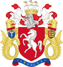
At the 2013 county council elections, control of Kent County Council was held by the Conservatives, who won 44 of the council's 83 seats. 17 seats were won by the United Kingdom Independence Party, 13 by the Labour Party, 7 by the Liberal Democrats, 1 by the Green Party and 1 by the Swanscombe and Greenhithe Residents Association. At the 2007 local elections[out of date], control of Medway Council was held by the Conservatives; 33 of the council's 55 seats were held by the Conservatives, 13 by the Labour Party, 8 by the Liberal Democrats and 1 by an Independent.[40] All but one of Kent's district councils are controlled by the Conservatives: a minority Labour administration took control of Thanet District in December 2011 after a Conservative councillor defected to the Independent group. In the council elections of May 2015 the United Kingdom Independence Party (UKIP) took control of the Council[which?], the first and so far only one in the UK. In October 2015 UKIP lost overall control following a series of resignations, although remaining the largest party, only for UKIP to regain control once more following ward elections in August 2016.
At the national level, Kent is represented in
since 2017.Demography
At the
The tables below provide statistics for the administrative county of Kent, that is, excluding Medway.
| Married couples with/without children | Sole occupants | Unmarried couples with/without children | Lone parents | Shared homes and institutions |
|---|---|---|---|---|
| 210,671 | 174,331 of which 79,310 over aged 65 | 63,750 | 60,645 | 77,877 |
| Unit | Claimants | Population (April 2011) | |
|---|---|---|---|
| August 2012 | August 2001 | ||
| Kent | 55,100 | 89,470 | 1,463,740 |
| % of 2011 Kent resident population (2001 population where applicable) |
3.8% | 6.7% | - |
| Three highest-ranking districts | |||
| Thanet | 6.5% | 11.3% | 134,186 |
| Folkestone and Hythe | 4.9% | 8.9% | 107,969 |
| Swale | 4.8% | 7.5% | 135,835 |
| Three lowest-ranking districts | |||
| Tonbridge and Malling | 2.5% | 4.4% | 120,805 |
| Sevenoaks | 2.3% | 4.3% | 114,893 |
| Tunbridge Wells | 2.2% | 5.1% | 115,049 |
Economy

At the
The average hours worked per week by residents of Kent were 43.1 for males and 30.9 for females. Their industry of employment was 17.3% retail, 12.4% manufacturing, 11.8% real estate, 10.3% health and social work, 8.9% construction, 8.2% transport and communications, 7.9% education, 6.0% public administration and defence, 5.6% finance, 4.8% other community and personal service activities, 4.1% hotels and restaurants, 1.6% agriculture, 0.8% energy and water supply, 0.2% mining, and 0.1% private households. This is higher than the whole of England for construction and transport/communications and lower for manufacturing.
Kent is sometimes known as the "Garden of England" for its abundance of orchards and hop gardens. In particular the county produces tree-grown fruits,[42] strawberries and hazelnuts.[43] Distinctive hop-drying buildings called oasts are common in the countryside, although many have been converted into dwellings. Nearer to London, market gardens also flourish. Kent is the main area for hazelnut production in the UK.
However, in recent years, there has been a significant drop in agriculture, and industry and services are increasing their utilisation of the area. This is illustrated by the following table of economic indicator gross value added (GVA) between 1995 and 2003[out of date] (figures are in £ millions):[44]
| Year | Regional GVA[A] | Agriculture | Industry[B] | Services[C] | |||
|---|---|---|---|---|---|---|---|
| County of Kent (excluding Medway) | |||||||
| 1995 | 12,369 | 379 | 3.1% | 3,886 | 31.4% | 8,104 | 65.5% |
| 2000 | 15,259 | 259 | 1.7% | 4,601 | 30.2% | 10,399 | 68.1% |
| 2003 | 18,126 | 287 | 1.6% | 5,057 | 27.9% | 12,783 | 70.5% |
| Medway | |||||||
| 1995 | 1,823 | 21 | 3.1% | 560 | 31.4% | 1,243 | 68.2% |
| 2000 | 2,348 | 8 | 1.7% | 745 | 30.2% | 1,595 | 67.9% |
| 2003 | 2,671 | 10 | 1.6% | 802 | 27.9% | 1,859 | 69.6% |
| A Components may not sum to totals due to rounding |
| B includes energy and construction |
| C includes financial intermediation services indirectly measured |
North Kent is heavily industrialised, with cement-making at
Cement-making, papermaking, and coal-mining were important industries in Kent during the 19th and 20th centuries. Cement came to the fore in the 19th century when massive building projects were undertaken. The ready supply of chalk and huge pits between
Kent's original paper mills stood on streams like the River Darent, tributaries of the River Medway, and on the River Stour. Two 18th century mills were on the River Len and at Tovil on the River Loose. In the late 19th century huge modern mills were built at Dartford and Northfleet on the River Thames and at Kemsley on The Swale. In pre-industrial times, almost every village and town had its own windmill or watermill, with over 400 windmills known to have stood at some time. Twenty-eight survive within the county today, plus two replica mills and a further two in that part of Kent now absorbed into London. All the major rivers in the county were used to power watermills.
From about 1900, several coal pits operated in East Kent. The Kent Coalfield was mined during the 20th century at several collieries,[47] including Chislet, Tilmanstone, Betteshanger, and the Snowdown Colliery, which ran from 1908 to 1986.[48]
The west of the county (including Tunbridge Wells, Tonbridge, and Sevenoaks) has less than 50% of the average claimant count for low incomes or worklessness as the coastal districts of Dover, Folkestone and Hythe, and Thanet (chiefly three resorts: Ramsgate, Broadstairs, and Margate). West and Central Kent have long had many
Culture
Architecture
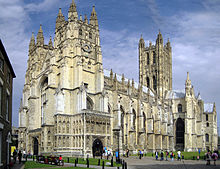
Kent's geographical location between the Straits of Dover and London has influenced its architecture, as has its
The sites of Richborough Castle and Dover Castle, along with two strategic sites along Watling Street, were fortified by the Romans and the Dukes of Kent. Other important sites include Canterbury city walls and Rochester Castle.[50] There remained a need to defend London and thus Kent. Deal Castle, Walmer Castle, Sandown Castle (whose remains were eroded by the sea in the 1990s) were constructed in late mediaeval times, and HM Dockyard, at Chatham and its surrounding castles and forts—Upnor Castle, Great Lines, and Fort Amherst—more recently.
Kent has three unique vernacular architecture forms: the
Kent has bridge trusts to maintain its bridges, and though the great bridge (1387) at Rochester was replaced there are medieval structures at Aylesford, Yalding and Teston.[51] With the motorways in the late twentieth century came the M2 motorway bridge spanning the Medway and the Dartford tunnel and the Dartford Bridge spanning the Thames.
Literature and publishing
Kent has provided inspiration for several notable writers and artists. Canterbury's religious role gave rise to
Classical music
Many notable musicians have been associated with Kent.[55] Walter Galpin Alcock, composer and organist, who played the organ at the coronations of Edward VII, George V and George VI, was born at Edenbridge in 1861. Richard Rodney Bennett, composer and pianist, was born at Broadstairs in 1936. Alfred Deller, counter-tenor singer, was born at Margate in 1912. Orlando Gibbons, composer and organist, died in Canterbury on 5 June 1625 and is buried in the cathedral. George Frideric Handel took the waters at Royal Tunbridge Wells in 1734 and 1735. Wolfgang Amadeus Mozart, together with his father, mother and sister, stayed at Bourne Park House near Canterbury, 25-30 July 1765. The nights of 24 and 30 July were spent in Canterbury, where they also went to the horse races. Nikolai Rimsky-Korsakov, then an 18-year-old sea cadet, was anchored at Gravesend from November 1862 to February 1863; while there, he completed the slow movement of his First Symphony. Malcolm Sargent, conductor, was born at Ashford in 1895. Thomas Tallis, composer and organist, was a lay clerk of Canterbury Cathedral around 1541-2. Peter Warlock, composer and writer on music, and Ernest John Moeran, composer, resided at Eynsford from 1925 to 1928; Arnold Bax, William Walton and Constant Lambert visited them here. Percy Whitlock, organist and composer, was born at Chatham in 1903.
Visual arts
A number of significant artists came from Kent, including Thomas Sidney Cooper, a painter of landscapes, often incorporating farm animals,[56] Richard Dadd, a maker of faery paintings, and Mary Tourtel, the creator of the children's book character, Rupert Bear. The artist Clive Head was also born in Kent. The landscape painter J. M. W. Turner spent part of his childhood in the town of Margate in East Kent, and regularly returned to visit it throughout his life. The East Kent coast inspired many of his works, including some of his most famous seascapes.[57] Kent has also been the home to artists including Frank Auerbach, Tracey Emin and Stass Paraskos.
Kent was also the location of the largest number of art schools in the country during the nineteenth century, estimated by the art historian David Haste, to approach two hundred. This is believed to be the result of Kent being a front line county during the Napoleonic Wars. At this time, before the invention of photography, draughtsmen were used to draw maps and topographical representations of the fields of battle, and after the wars ended many of these settled permanently in the county in which they had been based. Once the idea of art schools had been established, even in small towns in Kent, the tradition continued, although most of the schools were very small one-man operations, each teaching a small number of daughters of the upper classes how to draw and make watercolour paintings. Nonetheless, some of these small art schools developed into much larger organisations, including Canterbury College of Art, founded by Thomas Sidney Cooper in 1868, which is today the University for the Creative Arts.[58]
Blean near Canterbury was home to Smallfilms, the production company founded by Oliver Postgate and Peter Firmin and responsible for children's TV favourites Noggin the Nog, Ivor the Engine and Bagpuss.
Performing arts
The county's largest theatre is the Marlowe Theatre in the centre of Canterbury.[59]
Music festivals that take place in Kent include Chilled in a Field Festival, Electric Gardens, Hop Farm Festival, In the Woods Festival, Lounge On The Farm and the annual Smugglers Festival near Deal. Other venues for live music include Leas Cliff Hall in Folkestone and the Assembly Hall in Tunbridge Wells.
Kentish independence
Kentish people have long viewed themselves as Kentish first and British second, and to this day refer to themselves as either 'Men of Kent' or 'Kentish men' depending on whether they live to the East or West of the River Medway.[15] After the 2016 Brexit referendum and subsequent proposals for "border checks" on the Kentish border, effectively making Kent a country within a country,[60] this pride in being Kentish began to form into calls from some areas for an independent Kent or an autonomous republic within the UK, especially from the county's prominent newspapers, with the idea being discussed in detail in some areas[61] - with some ideas such as mock passports[62] and "tongue-in-cheek" manifestos being created.[63] These calls for independence can be explained by the individualistic and rebellious mentality that has always existed in the county, which can be explained by the counties position in the very South-East of the United Kingdom, having been a prominent and independent kingdom for centuries as well as being the source of many major rebellions that have occurred in the United Kingdom.
Transport
Roads
With the Roman invasion, a road network was constructed to connect London to the Channel ports of Dover,
In the run-up to
Water
The medieval
Railways

The earliest locomotive-driven passenger-carrying railway in Britain was the
The two companies merged in 1899, forming the
The
In addition to the "main line" railways, there are several light, heritage, and industrial railways in Kent. There are three heritage, standard gauge railways;
Air
In 2002, it was revealed that the government was considering building a new four-runway airport on the marshland near the village of
Manston Airport, located near the village of Manston in the Thanet district, was a former RAF facility that also handled some civilian flights. It closed in 2014.[77]
Education
Kent has four universities:
Although much of Britain adopted a
Together, the two Kent authorities have 38 of the 164 grammar schools remaining in Britain.[78][79]
Kent County Council has the largest education department of any local council in Britain,[80] providing school places for over 289,000 pupils.
In 2005–06, Kent County Council and Medway introduced a standardised school year, based on six terms, as recommended by the Local Government Association in its 2000 report, "The Rhythms of Schooling".[81]
Kent County Council Local Education Authority maintains 96 secondary schools, of which 33 are selective schools and 63 are
| Schools in Kent (data from 2000)[82] | |||||||||
|---|---|---|---|---|---|---|---|---|---|
| LEA | Nursery | Primary | Secondary (modern) |
Secondary (grammar) |
Special |
Pupil Referral Units |
Independent | City Technology College |
Total |
| KCC | 1 | 475 | 74 | 32 | 34 | 11 | 83 | 1 | 711 |
| Medway | 0 | 89 | 14 | 6 | 3 | 1 | 7 | 0 | 120 |
Music education is provided by Kent Music (formerly Kent Music School),[83] which has its origins in the 1940s. Kent Music provides services across the county including Kent County Youth Orchestra, Kent Youth Choirs, and an annual summer school at Benenden School.
National Challenge schools
In 2010, Kent had the highest number of National Challenge schools in England: schools which are branded 'failing' based on the British Government's floor targets that 30% of pupils achieve at least 5 GCSE grades A* to C.[84] Of the 63 secondary modern schools, 33 missed this target; thus 52% of Kent secondary modern schools (34% out of all 96 maintained secondary schools) are 'failing'.[85]
Sport
In association football, Kent's highest ranked football team is
Kent is represented in cricket by Kent County Cricket Club. The club was a founder member of the County Championship in 1890 and has won the competition, the major domestic first-class cricket competition, seven times. The club is based at the St Lawrence Ground in Canterbury and also plays matches at the Nevill Ground in Royal Tunbridge Wells and the County Cricket Ground, Beckenham.[87] The Kent Women cricket team has won the Women's County Championship seven times since it was established in 1997. Cricket has traditionally been a popular sport in the county and Kent is considered one of the locations in which the game first developed. Teams have represented the county since the early 18th century. The Kent Cricket League is the top level of club competition within Kent and features teams from throughout the county, including areas such as Beckenham and Bexley which were formerly part of the county.
Canterbury Hockey Club and Holcombe Hockey Club both play in the top division in both the men's and women's England Hockey Leagues. Sevenoaks Hockey Club's women first XI plays in the second tier of national competition.
The Invicta Dynamos, based in Gillingham, are a semi-professional ice hockey team that plays in the National Ice Hockey League. They replaced the Medway Bears as the senior team in 1997. They share the home ice rink at Planet Ice Gillingham with the secondary senior team, Invicta Mustangs and the ladies ice hockey team, the Invicta Dynamics.
In
In motorsport, the Brands Hatch circuit near Swanley has played host to a number of national and international racing events and hosted 12 runnings of the British Grand Prix in various years between 1964 and 1986.
There have been multiple American football teams based in Kent since the game was popularised in the UK. Currently, the Canterbury is the home of the East Kent Mavericks, the 2023 BAFA National Leagues Southern Football Conference 2 Champions, as well as teams from both universities.
Kent is home to two National League netball clubs, both based in northwest Kent: Telstars (Premier Division 2) and KCNC (Premier Division 3).
In basketball, the Kent Panthers participate in Division 3 of the National Basketball League.
The 2021–2022 season has seen three Kentish clubs demoted from the third-tier of their respective sports to the fourth-tier, with rugby clubs
News and media
Television
Much of Kent is served by the
Radio
Kent has two county-wide stations –
The county's first commercial station was originally known as Invicta FM and began broadcasting in 1984. After various buyouts, the station was rebranded into Heart Kent in 2009 as part of the Heart Network. The station was closed and merged with several other Heart stations in the south of England in 2019 to form Heart South, with the Kent studios in Whitstable closing and production moving to Fareham in Hampshire.
There are several community radio stations in Kent including:
- Academy FM (Folkestone).
- Academy FM (Thanet)
- Ashford FM (Ashford) on 107.1 FM.
- BRFM 95.6 FM (Sheppey)
- Cabin FM broadcasting to Herne Bay on 94.6FM.
- Cinque Ports Radio 100.2FM for Romney Marsh, Rye and Hythe.
- CSR 97.4FM (Canterbury) now only available via online listening.
- Deal Radio (Deal): online only.
- Dover Community Radio (DCR) Dover: currently online only; due to start broadcasting to Dover District on 104.9FM from May 2022.
- Radio Faversham (Faversham): online only.
- Maidstone Community Radio (MCR): online only.
- Miskin Radio (Dartford and Gravesend): online only.
- SFM 106.9FM (Sittingboune)
- Sheppey FM 92.2 (Sheppey)
- Shoreline Easy (Romney Marsh), online only.
- West Kent Radio (WKCR) serving Tonbridge, Tunbridge Wells and Sevenoaks. 95.5 and 106.7FM.
- Whitstable Bay Radio (Whitstable): online only.
Newspapers
The
See also
- Custos Rotulorum of Kent – list of Keepers of the Rolls
- Duke of Kent
- Kent (UK Parliament constituency) – historical list of MPs for Kent constituency
- Kent Community Network
- Kent Police and Crime Commissioner
- List of churches in Kent
- List of civil parishes in Kent
- List of fire stations in Kent
- List of hills of Kent
- List of Lord Lieutenants
- List of people from Kent
- List of places in Kent
- List of tourist attractions in Kent
- Recreational walks in Kent
- Thames Gateway – includes details of regeneration projects in the northern areas of Kent
- Category:Towns in Kent
- Category:Villages in Kent
- Fergus and Judith Wilson
References
- ^ "No. 62943". The London Gazette. 13 March 2020. p. 5161.
- ^ "2011 Census: Cultural diversity in Kent" (PDF). Kent City Council. Archived (PDF) from the original on 5 November 2021. Retrieved 18 October 2021.
- ^ "Kent | county, England, United Kingdom". Encyclopedia Britannica. Archived from the original on 22 April 2018. Retrieved 1 January 2020.
- ^ G. O. Sayles, The Medieval Foundations of England (London 1967). p. 186.
- from the original on 13 January 2022. Retrieved 28 May 2023.
- Etymonline. 12 November 1949. Archivedfrom the original on 16 September 2017. Retrieved 16 September 2017.
- ^ ISBN 9781902674346.
- ISBN 9780752431369.
- ISBN 9780713430691.
- ^ Susan Harrington and Stuart Brookes, The Kingdom of Kent and Its People, AD 400–1066, pp. 24, 35.
- ^ Witney, K. P. (1982). The Kingdom of Kent.
- ^ "Victoria County History of Kent". KentArchaeology.org.uk. May 2006. Archived from the original on 16 February 2007. Retrieved 20 April 2007.
- ^ "Archbishop of Canterbury". Spartacus.SchoolNet.co.uk. Archived from the original on 18 June 2007. Retrieved 19 June 2007.
- ISBN 978-0-19-821716-9
- ^ a b Griffiths, Rhys (11 June 2020). "Are you a Kentish Man or a Man of Kent and which side of the Medway is the best place to be?". Kent Online. Archived from the original on 27 July 2020. Retrieved 27 July 2020.
- ^ Graham, James (11 April 2023). "The River Medway: The river of Kent or Kentish river?". British Heritage. Archived from the original on 27 July 2020. Retrieved 27 July 2020.
- ^ Bates, David (1975). The Character and Career of Odo, Bishop of Bayeux (1049/50-1097). Speculum.
- ^ "Peasants' Revolt". Britannia.com. Archived from the original on 4 April 2007. Retrieved 20 April 2007.
- ^ "Wyatt's Rebellion". Brit Politics. Britology Ltd. Archived from the original on 4 March 2016. Retrieved 5 September 2015.
- ^ The Historic Dockyard Chatham – where legends were created. Jarrold Publishing. 2005.
- ^ "The Dutch in the Medway". DeRuyter.org. Archived from the original on 17 May 2007. Retrieved 20 April 2007.
- ISBN 978-1-870598-24-8.
- ^ "South-East England". Smuggler's Britain. Archived from the original on 16 May 2007. Retrieved 20 April 2007.
- ^ a b c d Jessup, Frank W. (1966). Kent History Illustrated. Kent County Council.
- ^ "Medway". Communities and Local Government. Archived from the original on 27 April 2007. Retrieved 20 April 2007.
- ^ English Channel. Microsoft Encarta Online Encyclopedia 2007. Archived from the original on 21 June 2008. Retrieved 20 April 2007.
- ^ ISBN 978-1-873010-23-5.
- ^ L.Dudley Stamp, Pub September 1946, Collins New NaturalistSeries.
- ^ "Kent Downs". KentDowns.org. Archived from the original on 5 April 2007. Retrieved 20 April 2007.
- ^ "Geology of Kent and Boulonnais". The Geology Shop. 2000. Archived from the original on 5 November 2009. Retrieved 8 August 2009.
- ^ Hill, Amelia; McKie, Robin (29 April 2007). "Quake causes Kent families to flee homes". The Observer. London. Archived from the original on 31 May 2007. Retrieved 28 April 2007.
- ^ "Kent hit by 4.2 earthquake, shaking houses and waking residents". The Guardian. London. 22 May 2015. Archived from the original on 7 June 2015. Retrieved 7 June 2015.
- ^ a b Bowskill, Derek. Map of the River Medway.
- ^ "Environmental Agency: River Medway". Archived from the original on 5 June 2011.
- London Evening Standard. p. 8. Archivedfrom the original on 27 November 2018. Retrieved 29 November 2018.
- ^ "UK Records". BBC Weather. Archived from the original on 26 January 2009. Retrieved 10 June 2009.
- ^ Climate averages 1981–2010 Archived 24 March 2014 at the Wayback Machine. Met Office (19 November 2008). Retrieved on 17 July 2013.
- ^ Kent (Borough of Gillingham and City of Rochester upon Medway) (Structural Change) Order 1996 "Kent (Borough of Gillingham and City of Rochester upon Medway) (Structural Change) Order 1996". HMSO. Archived from the original on 19 December 2010. Retrieved 17 March 2010.
- ^ "Council and democracy". Kent County Council. Archived from the original on 6 February 2007. Retrieved 19 April 2007.
- ^ "Democratically elected representatives in Medway". Medway Council. Archived from the original on 12 May 2007. Retrieved 13 May 2007.
- ^ a b c d e "Neighbourhood Statistics". Statistics.gov.uk. Archived from the original on 31 July 2013. Retrieved 5 May 2013.
- ^ Climate Change Risk and Impact Assessment for Kent and Medway – Part 2: Agriculture Sector Summary (PDF) (Report). Kent County Council. June 2020. Archived from the original (PDF) on 7 March 2021.
- ^ "Hazelnut and walnut production" (PDF). Calu. Archived from the original (PDF) on 21 April 2013. Retrieved 15 January 2013.
- ^ "Regional Gross Value Added" (PDF). Office for National Statistics. Archived from the original (PDF) on 28 July 2011. Retrieved 3 April 2007.
- ^ "Closure of Dungeness Power Station". BBC News. 31 December 2006. Archived from the original on 15 March 2007. Retrieved 3 April 2007.
- ^ "The Chatham News Index" (PDF). Parret & Neves. 1996. Archived from the original (PDF) on 14 October 2006. Retrieved 19 April 2007.
- ^ "Coal fields Heritage Initiative". Dover Museum. Archived from the original on 20 February 2007. Retrieved 20 April 2007.
- ^ "Snowdown Colliery". FreeUK.com. Archived from the original on 11 March 2008. Retrieved 19 April 2007.
- ISBN 978-0140710397.
- ISBN 978-0140710397.
- ISBN 978-0140710397.
- ^ "Charles Dickens". InfoBritain. Archived from the original on 17 April 2007. Retrieved 20 April 2007.
- ^ "William Golding – Biography". William-Golding.co.uk. Archived from the original on 24 February 2003. Retrieved 20 June 2007.
- ^ Paull, John (2021). Organic Agriculture - Invented in Kent Archived 14 May 2021 at the Wayback Machine, Kent Maps Symposium, Canterbury Christ Church University, Canterbury, 5 May.
- ^ Gerald Norris, A Musical Gazetteer of Great Britain & Ireland (David & Charles, 1981).
- ^ Edward Strachan and Roy Bolton, Russia & Europe in the Nineteenth Century (London: Sphinx Fine Art, 2008 ) p. 46.
- ^ "The Turner Connection". TurnerContemporary.org. Archived from the original on 23 July 2007. Retrieved 20 June 2007.
- ^ David Haste, The Art Schools of Kent (London: Werther Books, 2014).
- ^ Kennedy, Maev (28 September 2011). "Marlowe theatre: curtain rises on Canterbury's £25.6m revamp". The Guardian. London. Archived from the original on 28 December 2014. Retrieved 23 December 2011.
- ^ O'Carroll, Lisa (23 September 2020). "Lorry drivers will face de facto Brexit border in Kent, Gove confirms". The Guardian. Retrieved 4 June 2022.
- ^ West, Patrick (24 September 2020). "An independent Kent isn't as ridiculous as it sounds". The Spectator. Retrieved 4 June 2022.
- ^ "Welcome to the Republic of Kent!". Kent Online. 24 September 2020. Retrieved 4 June 2022.
- ^ James, John (24 September 2020). "The radical steps Kent must take to thrive as an 'independent nation'". KentLive. Retrieved 4 June 2022.
- ^ McConnell, Ed (3 September 2020). "Worst case post-Brexit lorry havoc scenario for Kent revealed by Michael Gove to House of Commons". kentonline.co.uk. Archived from the original on 27 September 2020. Retrieved 7 February 2021.
- ^ "Brexit: Lorry drivers will need a permit to enter Kent after transition period". BBC News. 23 September 2020. Archived from the original on 4 January 2021. Retrieved 7 January 2021.
- ^ "Check an HGV is ready to cross the border (Kent Access Permit)". GOV.UK. 31 December 2020. Archived from the original on 30 January 2021. Retrieved 7 February 2021.
- ^ Oppitz, Leslie. "The lost railway". BBC. Archived from the original on 6 December 2008. Retrieved 1 August 2008.
- ^ a b "History of the South Eastern & Chatham Railway". The South Eastern & Chatham Railway Society. Archived from the original on 1 November 2006. Retrieved 22 April 2007.
- ^ "Failed rail franchise 'needed time'". BBC. 13 November 2003. Archived from the original on 2 July 2004. Retrieved 13 May 2007.
- ^ "Rail workers vote to hold strikes". BBC. 13 April 2006. Archived from the original on 14 April 2006. Retrieved 13 May 2007.
- ^ "New station means Eurostar change". BBC. 12 September 2006. Archived from the original on 27 August 2007. Retrieved 22 April 2007.
- ^ Davis, Matthew (12 September 2006). "Airport plan threatens Dickens' legacy". BBC. Archived from the original on 29 May 2006. Retrieved 20 June 2007.
- ^ Feature, Advertisement (23 March 2008). "Saving nature". The Times. London. Archived from the original on 29 May 2010. Retrieved 6 September 2009.
- ^ Gwyn Topham and Nicholas Watt. "'Boris Island' airport plan grounded over Johnson's briefing to Telegraph". The Guardian. London. Archived from the original on 14 July 2014. Retrieved 19 August 2014.
- ^ a b "Nature blow to plans for "Boris Island"". The Daily Telegraph. London. Archived from the original on 28 October 2014. Retrieved 19 August 2014.
- ^ "'Boris Island' London Airport designs unveiled". BBC News. 11 November 2013. Archived from the original on 9 July 2014. Retrieved 19 August 2014.
- ^ "Threatened airport to shut next week". BBC News. 6 May 2014. Archived from the original on 27 July 2020. Retrieved 6 July 2020.
- ^ a b Garner, Richard (20 January 2007). "Call for end to selective education as 'grammar school areas' fail". The Independent. UK. Archived from the original on 27 January 2007. Retrieved 14 May 2007.
- ^ "Grammar schools have expanded". BBC News. 26 March 2004. Archived from the original on 29 August 2007. Retrieved 3 April 2007.
- ^ "Kent's selective schools compared". BBC News. 17 January 2003. Archived from the original on 14 February 2007. Retrieved 13 May 2007.
- ^ "Kent County Council". Kent County Council. Archived from the original on 25 February 2011. Retrieved 3 April 2007.
- ^ "Department for Education and Skills". Department for Education and Skills. Archived from the original on 2 April 2007. Retrieved 13 May 2007.
- ^ Kent Music & Soundhub: Annual Report 2015 (PDF) (Report). Kent Music. Archived from the original (PDF) on 24 August 2017. Retrieved 24 August 2017.
- ^ "Brown threatens 'failing' schools". BBC News. 31 October 2007. Archived from the original on 13 January 2022. Retrieved 4 April 2010.
- ^ [1] Archived 3 June 2012 at the Wayback Machine
- ^ "Report | Gillingham 0-2 Rotherham United". www.gillinghamfootballclub.com. Retrieved 6 June 2022.
- ^ We ended up with a lake – Kent CEO Jamie Clifford Archived 19 June 2012 at the Wayback Machine. BBC Sport (13 June 2012). Retrieved on 17 July 2013.
- ^ Clarkson, Stuart (16 February 2012). "KMFM group can have one breakfast show". Radio Today Industry News. Archived from the original on 17 February 2016. Retrieved 5 September 2015.
External links
- Kent at Curlie
- Kent County Council – local government website
- BBC – origins of Kent placenames
- Images of Kent at the English Heritage Archive


