
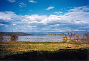
Great Rift Valley, Kenya


The Great Rift Valley is part of an intra-continental ridge system that runs through
The valley contains the
In March 2018, a giant crack in the Earth, measuring 50 feet deep and 65 feet across, opened in the ground just west of Nairobi. [5] However, it is believed to be due to rain and erosion, and not of tectonic origin. [6]
Features

The valley is bordered by
Lake Turkana occupies the northern end of the Great Rift Valley in Kenya. There are also volcanoes in Lake Turkana. The
The Hell's Gate National Park lies south of Lake Naivasha.[8] In the early 1900s, Mount Longonot erupted, and ash can still be felt around Hell's Gate.[9] Mount Longonot is a dormant stratovolcano located southeast of Lake Naivasha. Mount Suswa is a shield volcano located between Narok and Nairobi. Lava flows from the most recent eruptions are still not covered by vegetation, and may be no more than one hundred years old.[10] Lake Magadi is the most southern rift valley lake in Kenya, although the northern end of Lake Natron in Tanzania reaches into Kenya.
The
Lakes
| UNESCO World Heritage Site | |
|---|---|
 Lake Bogoria, one of the main lakes in the Great Rift Valley. | |
| Location | Rift Valley Province, Kenya |
| Includes |
|
| Criteria | Natural: (vii), (ix), (x) |
| Reference | 1060rev |
| Inscription | 2011 (35th Session) |
| Area | 32,034 ha (79,160 acres) |
| Buffer zone | 3,581 ha (8,850 acres) |
| Coordinates | 00°26′33″N 36°14′24″E / 0.44250°N 36.24000°E |
| Official name | Lake Turkana National Parks |
| Criteria | Natural: viii, x |
| Reference | 801bis |
| Inscription | 1997 (21st Session) |
| Extensions | 2001 |
 Location of Great Rift Valley, Kenya in Kenya | |
Kenya is home to 64 (9.50%) of the total lakes found within the continent of Africa.[11] Eight of these make up the main lakes in the Kenyan Rift Valley. From north to south, the names of these lakes are Lake Turkana, Lake Logipi, Lake Baringo, Lake Bogoria, Lake Nakuru, Lake Elmenteita, Lake Naivasha, and Lake Magadi.[3] Of those eight, only Lakes Baringo and Naivasha are fresh water.[12]

Lake Turkana, at the northern end of the rift, is 250 kilometres (160 mi) long, between 15 kilometres (9.3 mi) and 30 kilometres (19 mi) wide and is 125 metres (410 ft) at its greatest depth.[13] Most of the other lakes are shallow and poorly drained, and therefore have become alkaline. They have waters that are rich in blue-green algae, which feed insect larvae, small crustaceans and lesser flamingos. The larvae and crustaceans are food for fish and greater flamingos.[3] Massive flocks of these birds have been found to have an effect on the lakeside sediments also. Their numbers cause trampling of the silts in certain areas, while the feeding grounds are oxygenated due to probing beaks in the mud. Their nest mounds can also be preserved and cemented as the lake's water levels change. These form irregularities in the lakeside topography.[14]
Trona, an evaporative mineral, used for sodium carbonate production, has been mined at Lake Magadi for nearly 100 years. It produces about 250,000 metric tonnes per year.[15] Other precious minerals like rubies and pink sapphires have been found and mined from areas around Lake Baringo. In 2004, over 2 kilograms of Corundum were collected.[16]

Three shallow alkaline lakes and the surrounding lands make up the Kenya lake system:
The Kenya lake system is a key location on the
Other lakes are Lake Chew Bahir, in the northeast extension. This lake lies mainly in Ethiopia but extends into Kenya in the rainy season. Lake Kamnarok is another small lake.
Gallery
-
 Lake Baringo, August 1999
 -
![Sketch by John Walter Gregory from his expedition to East Africa in 1892-3. "[Mount] Kenya from the Kapte Plains west of Machakos"](//upload.wikimedia.org/wikipedia/commons/thumb/0/07/Gregory002.jpg/156px-Gregory002.jpg) Sketch by John Walter Gregory from his expedition to East Africa in 1892-3. "[Mount] Kenya from the Kapte Plains west of Machakos"
Sketch by John Walter Gregory from his expedition to East Africa in 1892-3. "[Mount] Kenya from the Kapte Plains west of Machakos" -
 The Great Rift Valley from near Eldoret, Kenya in the fall of 2006
 -
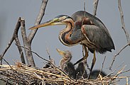 An adult purple heron with chicks on a nest at Lake Baringo
 -
 An African fish eagle about to catch a fish in Lake Naivasha

![Sketch by John Walter Gregory from his expedition to East Africa in 1892-3. "[Mount] Kenya from the Kapte Plains west of Machakos"](/File:Gregory002.jpg)


See also
Prehistory
Ethnic groups

- Afroasiatic Urheimat
- Ogiek language
- Omotik language
- Origins of Tutsi and Hutu
- Maasai people
- Elgeyo people
- Luhya people
- Sentinel Project for Genocide Prevention
Economy
People
In popular culture
References
- .
- .
- ^ a b c Firestone 2009, p. 151.
- ^ Firestone 2009, p. 23.
- ^ "A giant crack in Kenya opens up, but what's causing it?". CBS News. April 3, 2018.
- ^ "Africa is slowly splitting in two – but this 'crack' in Kenya has little to do with it". The Guardian. April 6, 2018.
- ^ Menengai.
- ISBN 9783319737850.
- ^ Hell's Gate.
- ^ Suswa.
- ^ Singh 2006, p. 2.
- ^ Britton & Harper 2006, p. 334.
- ^ Anadón, Cabrera & Kelts 1991, p. 6.
- .
- ISBN 978-3-540-26011-0.
- ^ Blauwet, Dudley; B. M. L. (1 June 2005). "New ruby and pink sapphire deposit in the Lake Baringo area, Kenya". Gems & Gemology. 41 (2): 177–178. Archived from the original on 3 March 2016.
- ^ a b UNESCO.
Sources
- Britton, J. Roberts; Harper, D. M. (August 2006). "Length–weight relationships of fish species in the freshwater rift valley lakes of Kenya". Journal of Applied Ichthyology. 22 (4): 334–336. .
- Anadón, P.; Cabrera, Ll; Kelts, K. R. (1991). Lacustrine facies analysis. John Wiley & Sons. ISBN 978-0-632-03149-8.
- Firestone, Matthew (2009). Kenya. Lonely Planet. ISBN 978-1-74104-773-8.
- "HELL'S GATE INTRODUCTION". WebKenya.
- "Menengai". Smithsonian. Retrieved 2011-12-26.
- Singh, Ashbindu (2006). Africa's Lakes: Atlas of Our Changing Environment. United Nations Environment Programme. ISBN 92-807-2694-3.
- "Suswa". Smithsonian. Retrieved 2011-12-26.
- UNESCO. "Kenya Lake System in the Great Rift Valley". Retrieved 2011-12-23.