Kfar Yona
Kfar Yona
| |
|---|---|
City (from 2014) | |
| Hebrew transcription(s) | |
| • Also spelled | Kefar Yona (official) |
 | |
| Coordinates: 32°19′1.57″N 34°56′8.74″E / 32.3171028°N 34.9357611°E | |
| Country | |
| District | Central |
| Founded | 23 January 1932 |
| Government | |
| • Mayor | Shosh Kahlon |
| Area | |
| • Total | 11,017 dunams (11 km2 or 4 sq mi) |
| Population (2022)[1] | |
| • Total | 29,450 |
| • Density | 2,700/km2 (6,900/sq mi) |
| Website | http://kfar-yona.muni.il/ |
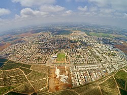
Kfar Yona (Hebrew: כְּפַר יוֹנָה, lit. 'Yona's Village') is a city in the Sharon subdistrict in the Central District of Israel. It is located between the cities Netanya and Tulkarm, about 8 km east of Netanya in the central junction between Highway 6 and Highway 4. The village was established in 1932 by Maurice Fischer and was declared a local council in the year 1940. Following developments in the fields of construction, industry and, education, the local council received city status in February 11th 2014. In 2024 the city has a jurisdiction of 11,550 dunams (~11.55 km2) and a population of 29,953.
History

Before the 20th century, Kfar Yona formed part of the Forest of Sharon, a hallmark of the region's historical landscape. It was an open woodland dominated by Mount Tabor Oak (Quercus ithaburensis), which extended from Kfar Yona in the north to Ra’ananna in the south. The local Arab inhabitants traditionally used the area for pasture, firewood and intermittent cultivation. The intensification of settlement and agriculture in the coastal plain during the 19th century led to deforestation and subsequent environmental degradation known from Hebrew sources.[2]
Kfar Yona was established on lands in the Sharon plain purchased in 1932 from Mustafa Bushnaq and the Shanti family of Qalqilya.[3]
Kfar Yona is named for Jean (Yona) Fischer, a Belgian Zionist.


In the
Kfar Yona was surrounded by orchards and its main income was from selling oranges. Most of these orchards are now the site of new neighborhoods.
Next to Kfar Yona is the Area 21 military base, named for
Neighborhoods
Kfar Yona Alef

The original ten homes and the first community building. The homes are small, one-story, private structures, with an average of three rooms each. The community building stands today empty and is falling into ruin, though the town council is interested in maintaining it for its sentimental and historical value. Alef also includes a new neighborhood accessed from the western entrance to the village, with recently built family homes and more under construction. The main avenue of this section of Alef is a street where residents of the village can be found walking or jogging at any hour. For the past year, the west entrance has had a gate and guard that operates from 11 pm to 6 am. The whole village is policed by a volunteer guard force, supervised by a small professional security team, for which the town residents pay a small municipal tax.
Kfar Yona Bet

Cheaper apartment buildings, which are the first site of the village for visitors who enter from the eastern entrance. (Both entrances are on Highway 57, the eastern entrance is about 2 km further down the road than the western entrance, when driving from Highway 2, Israel's main Coastal Road). The east entrance is completely shut and locked from 11 pm to 6 am. Bet also includes the New Project, which are lower apartment buildings, with bigger homes. The New Project on Menachem Begin Street faces the City Council building, the Community Center (funded by Jewish Federation of Greater Vancouver sister-city fundraising activities), the community basketball courts and water park (also a gift from Vancouver), and the Hadar Elementary School (Grades 1–6). Beyond the New Project, Bet includes more expensive townhouses and private homes. It also includes the Betzali Park.
Heftziba

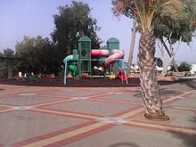
Down Menachem Begin Street is Heftziba named for the construction company that built it. On top of the hill is an old mansion that belonged an Arab who married a Jewish woman. Across Highway 57 is the new neighborhood of Alonim, also known as Kfar Yona Gimel. This neighborhood includes single-family homes, wide streetsand several parks
Sports and culture
The community center operates a music conservatory and holds public concerts. In 2006, 250 grade-school students participated in a basketball program. The older student's league has won championships. The community center holds classes in photography, ceramics, pottery and cooking.
Education
In 2010, Kfar Yona had 3 state schools, Hadar, Rimon and Amal, and a state-religious school, Bar Ilan. The town also has a junior high and high school, Ish Shalom.[5]
Transportation
The city has no railway connection and since 2014 has been served by the Kavim bus company, which replaced Nateev Express.
Sister cities
 Oranienburg, Brandenburg, Germany[6]
Notable people
- Zvi Bar
- Zoya Semenduev
- Yaakov Turner
References
- ^ "Regional Statistics". Israel Central Bureau of Statistics. Retrieved 21 March 2024.
- ^ Marom, Roy (2022-12-01). "יער השרון (אל-ע'אבה) בתקופה העות'מאנית: בתקופה מהמחקר חדשות תובנות הגיאוגרפי-היסטורי The Oak Forest of the Sharon (al-Ghaba) in the Ottoman Period: New Insights from Historical- Geographical Studies". Muse. 5: 90–107.
- ^ Army of Shadows: Palestinian Collaboration with Zionism, 1917–1948, Hillel Cohen
- ^ a b Vilnai, Ze'ev (1976). "Kfar Yona". Ariel Encyclopedia (in Hebrew). Vol. 4. Israel: Am Oved. p. 3756.
- ^ Kfar Yona
- ^ "First, Historical Cooperation for Kfar Yona: Sister Cities", Rashuyot Magazine, 11 October 2021 (source in Hebrew)
External links
- Official website (in Hebrew)


