
Kfarhata
Kfarhata
كفرحاتا | |
|---|---|
City | |
UTC+3 (EEST) | |
| Dialing code | +961 |
Kfarhata (also known as Kfar Hata or Kafrhata,
El-Koura, situated at the southern region of this district, at the other side of Al-Kateh (The cutter); a shallow but wide valley, separating a group of 6 towns from the gigantic El-Koura olive plains. In 1953, Kfar Hata had a population of 590 living in 64 households.[1]
The population is
Maronite.[2]
Although the mountainous profile of this town, the
Koranian
cold technique.
-
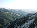 Poster El-koura "Cutter". Western view
 -
 Poster El-koura "Cutter". Eastern view


See also
References
- hdl:10938/3411. Archived from the original(PDF) on 24 March 2023. Retrieved 2023-03-24.
- ^ "Municipal and ikhtiyariah elections in Northern Lebanon" (PDF). The Monthly. March 2010. p. 23. Archived from the original on 3 June 2016. Retrieved 31 October 2016.
{{cite web}}: CS1 maint: bot: original URL status unknown (link)
External links
- Kfar Hata, Localiban
Capital: Amioun | ||
| Towns and villages |
|  |
| Notable landmarks | ||