
Khorramabad
Khorramabad
Shapuri bridge, View of the Khorramabad city, Brick Minaret , Panorama of Khorramabad | |
|---|---|
|
UTC+3:30 (IRST) | |
| Climate | Csa |
| Website | www.Khorramabad.ir |
Khorramabad (
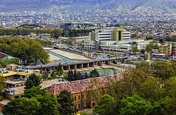
At the 2006 National Census, its population was 328,544 in 75,945 households.[6] The following census in 2011 counted 348,216 people in 94,747 households.[7] The latest census in 2016 showed a population of 373,416 people in 109,231 households.[3]
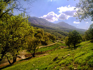
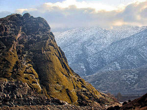
Khorramabad is in the Zagros Mountains. Khorramabad Airport is 3 km south of the city proper.[8]
Although not a major tourist destination, it is quite scenic and possesses several attractions, such as five Paleolithic cave-dwelling sites.[9]
Demographics
The city population is predominantly Lur and the largest Luri-speaking city in the country.[10][11] The linguistic composition of the city:[12]
History
Hazaraspids
The founder of the
Safavid dynasty
During the reign of the
Monuments

Brick minaret
This Iranian minaret is a combination of the Indian Stupa, commemorative columns, and the central Asia tradition of tower building for defensive and communication purposes.[15]
Sahpuri Bridge
Colleges and universities

- Islamic Azad University of Khorram Abad
- Lorestan University[16]
- Lorestan University of Medical Sciences[17]
- Madanni Technical College[18]
Sister cities and twin towns
| Country | City | State / Province / Region / Governorate | Date | ||||
|---|---|---|---|---|---|---|---|
| Turkey | Afyonkarahisar | Afyonkarahisar Province | 2015[19] | ||||
| Japan | Yamagata
|
Yamagata Prefecture | October 2013[20] | December 2020[21] | |||
Photo gallery
-
 Nojian oak forest, Khorramabad County
 -
 Makhmalkuh Khorramabad County
 -
 Shapur Khast
 -
 Keeyow lake, Khorramabad
 -
 Sarbazkhane building
 -
 Building in Khorramabad
 -
 Bisheh waterfall, Khorramabad County
 -
 Khorramabad


Climate
Khorramabad has mild and semi-humid Mediterranean climate with high amount of rainfall during spring and winter. It is the sixth cities in Iran having high level of annual rainfall. Khorramabad has what is classed under the
Highest recorded temperature: 47.0 °C (116.6 °F) on 14 August 1960 and 23 July 1961[22]
Lowest recorded temperature: −14.6 °C (5.7 °F) on 25 January 1990.[23]
| Climate data for Khorramabad (1951–2010, extremes 1951-2020) | |||||||||||||
|---|---|---|---|---|---|---|---|---|---|---|---|---|---|
| Month | Jan | Feb | Mar | Apr | May | Jun | Jul | Aug | Sep | Oct | Nov | Dec | Year |
| Record high °C (°F) | 24.0 (75.2) |
26.0 (78.8) |
31.0 (87.8) |
37.0 (98.6) |
41.0 (105.8) |
45.0 (113.0) |
47.0 (116.6) |
47.0 (116.6) |
43.0 (109.4) |
37.0 (98.6) |
34.0 (93.2) |
25.6 (78.1) |
47.0 (116.6) |
| Mean daily maximum °C (°F) | 10.9 (51.6) |
13.2 (55.8) |
17.3 (63.1) |
22.6 (72.7) |
29.0 (84.2) |
36.0 (96.8) |
39.6 (103.3) |
39.3 (102.7) |
35.1 (95.2) |
28.0 (82.4) |
19.2 (66.6) |
13.0 (55.4) |
25.3 (77.5) |
| Daily mean °C (°F) | 5.4 (41.7) |
7.2 (45.0) |
10.8 (51.4) |
15.4 (59.7) |
20.3 (68.5) |
25.7 (78.3) |
29.5 (85.1) |
29.0 (84.2) |
24.5 (76.1) |
18.9 (66.0) |
12.2 (54.0) |
7.3 (45.1) |
17.2 (62.9) |
| Mean daily minimum °C (°F) | −0.1 (31.8) |
1.1 (34.0) |
4.2 (39.6) |
8.1 (46.6) |
11.7 (53.1) |
15.4 (59.7) |
19.5 (67.1) |
18.8 (65.8) |
14.0 (57.2) |
9.8 (49.6) |
5.1 (41.2) |
1.5 (34.7) |
9.1 (48.4) |
| Record low °C (°F) | −14.6 (5.7) |
−11.5 (11.3) |
−11.0 (12.2) |
−7.0 (19.4) |
−1.8 (28.8) |
7.0 (44.6) |
9.2 (48.6) |
8.0 (46.4) |
4.6 (40.3) |
−1.4 (29.5) |
−7.8 (18.0) |
−12.0 (10.4) |
−14.6 (5.7) |
| Average precipitation mm (inches) | 78.0 (3.07) |
73.4 (2.89) |
84.0 (3.31) |
72.0 (2.83) |
29.3 (1.15) |
0.9 (0.04) |
0.3 (0.01) |
0.3 (0.01) |
1.0 (0.04) |
21.7 (0.85) |
60.9 (2.40) |
82.5 (3.25) |
504.3 (19.85) |
| Average precipitation days (≥ 1.0 mm) | 7.4 | 7 | 7.5 | 7.4 | 3.4 | 0.3 | 0.1 | 0 | 0.2 | 3 | 6 | 7 | 49.3 |
| Average rainy days | 10.9 | 9.9 | 11.9 | 11.3 | 5.2 | 0.4 | 0.2 | 0.1 | 0.3 | 4.5 | 9.5 | 10.7 | 74.9 |
| Average snowy days | 2.6 | 1.5 | 0.7 | 0 | 0 | 0 | 0 | 0 | 0 | 0 | 0.1 | 0.9 | 5.8 |
| Average relative humidity (%)
|
69 | 64 | 58 | 56 | 44 | 28 | 24 | 24 | 27 | 39 | 57 | 68 | 47 |
| Average dew point °C (°F) | −1.5 (29.3) |
−1.3 (29.7) |
0.5 (32.9) |
4.8 (40.6) |
5.1 (41.2) |
2.2 (36.0) |
3.4 (38.1) |
2.8 (37.0) |
0.3 (32.5) |
1.2 (34.2) |
2.0 (35.6) |
0.0 (32.0) |
1.6 (34.9) |
| Mean monthly sunshine hours | 162.8 | 173.6 | 198.3 | 214.5 | 276.7 | 340.5 | 345.5 | 335.0 | 304.9 | 258.9 | 195.4 | 162.9 | 2,969 |
| Source 1: [1] | |||||||||||||
| Source 2: NCEI(dew point, days with precipitation and rain 1991-2020)[24]
| |||||||||||||
See also
![]() Media related to Khorramabad at Wikimedia Commons
Media related to Khorramabad at Wikimedia Commons
References
- ^ OpenStreetMap contributors (25 August 2023). "Khorramabad, Khorramabad County" (Map). OpenStreetMap. Retrieved 25 August 2023.
- ^ https://www.irna.ir/news/85192859 [bare URL]
- ^ a b "Census of the Islamic Republic of Iran, 1395 (2016)". AMAR (in Persian). The Statistical Center of Iran. p. 15. Archived from the original (Excel) on 12 October 2020. Retrieved 19 December 2022.
- ^ Khorramabad can be found at GEOnet Names Server, at this link, by opening the Advanced Search box, entering "-3071194" in the "Unique Feature Id" form, and clicking on "Search Database".
- ^ "Approval of the organization and chain of citizenship of the elements and units of the country divisions of Lorestan province, centered in the city of Khorramabad". Lamtakam (in Persian). Ministry of Interior, Political and Defense Commission of the Government Board. 21 June 1369. Archived from the original on 19 January 2024. Retrieved 19 January 2024.
- ^ "Census of the Islamic Republic of Iran, 1385 (2006)". AMAR (in Persian). The Statistical Center of Iran. p. 15. Archived from the original (Excel) on 20 September 2011. Retrieved 25 September 2022.
- ^ "Census of the Islamic Republic of Iran, 1390 (2011)". Syracuse University (in Persian). The Statistical Center of Iran. p. 15. Archived from the original (Excel) on 19 January 2023. Retrieved 19 December 2022.
- ^ "Lorestan Province" (in Persian). Lorestan council of dispute resolution. Retrieved 22 April 2021.[permanent dead link]
- ISBN 978-0-924171-24-6
- ^ "Khorramabad is the largest city of Lurs" (in Persian). Yafte news agancy. 18 April 2018. Retrieved 22 April 2021.
- ^ "Language distribution: individual languages and language families". Iran Atlas. Retrieved 15 September 2023.
- ^ B. Spuller,Atabakan-e Lorestan[permanent dead link], Encyclopædia Iranica.
- ISBN 978-0810866065.
- OCLC 46455166.
- ^ Lorestan University" homepage, in English Archived September 20, 2010, at the Wayback Machine
- ^ "Lorestan University of Medical Sciences homepage". Lums.ac.ir. Retrieved 12 September 2012.
- ^ "afpkh.ir". afpkh.ir. Archived from the original on 11 September 2012. Retrieved 12 September 2012.
- ^ "خطا | خبرگزاری فارس". Archived from the original on 2 April 2015. Retrieved 2 March 2015.
- ^ "راهنمای ثبت شرکت در خرم آباد". www.Sabt-ag.ir.
- ^ "Shahin Souri". www.shahin-soori.ir.
- ^ "Form 7: Temperature records highest in C. Station: Khorramabad(40782)". chaharmahalmet. IRIMO. Archived from the original on 10 September 2014. Retrieved 25 March 2024.
{{cite web}}: CS1 maint: unfit URL (link) - ^ "Form 6: Temperature records lowest in C. Station: Khorramabad(40782)". chaharmahalmet. IRIMO. Archived from the original on 14 September 2014. Retrieved 25 March 2024.
{{cite web}}: CS1 maint: unfit URL (link) - NOAA. Retrieved 25 March 2024.
Parameter 71: No. of days with rain/drizzle, Parameter 46:No. of days with rain showers
External links
- Khorramabad municipality Archived 2015-03-14 at the Wayback Machine
| Periods |
|  | ||||
|---|---|---|---|---|---|---|
| Types | ||||||
| Elements | ||||||
| Traditional cities | ||||||
| Theory and analysis | ||||||
| Lists | ||||||
| National | |
|---|---|
| Geographic | |