
Khyber Pass
| Khyber Pass د خیبر درہ ( White Mountains (Spīn Ghar, Safēd Kōh) | |
|---|---|
| Coordinates | 34°04′33″N 71°12′14″E / 34.07570°N 71.20394°E |
 | |


The Khyber Pass (
Geography
Following Asian Highway 1 (
History
.jpg)
Historical invasions of the Indian subcontinent have been predominantly through the Khyber Pass, such as those of
The pass has been traversed by military expeditions launched by empires such as the Achaemenids and Sassanids, as well as by nomadic invaders from Central Asia, including the Saka, Yuezhi, and White Huns.[2] Indian empires rarely extended their control beyond the pass, with the Maurya king Čandragupta being an exception.[2]
The Khyber Pass has witnessed the spread of Greek influence into India and the expansion of Buddhism in the opposite direction.[2] Despite military activities, trade continued to thrive there.[2] The Khyber Pass became a critical part of the Silk Road, a major trade route from East Asia to Europe.[4][5]
The Parthian Empire fought for control of passes such as this to profit from the trade in silk, jade, rhubarb, and other luxuries moving from China to Western Asia and Europe. Through the Khyber Pass, Gandhara (in present-day Pakistan) became a regional center of trade connecting Bagram in Afghanistan to Taxila in Pakistan, adding Indian luxury goods such as ivory, pepper, and textiles to the Silk Road commerce.[6]: 74
During the Islamic period, Muslim rulers, including

In the 19th century, the
During World War II, concrete dragon's teeth were erected on the valley floor due to British fears of a German tank invasion of India.[9]

Following the
The Pass became widely known to thousands of Westerners and Japanese who traveled it in the days of the hippie trail, taking a bus or car from Kabul to the Afghan border. At the Pakistani frontier post, travellers were advised not to wander away from the road, as the location was a barely controlled Federally Administered Tribal Area. Then, after customs formalities, a quick daylight drive through the Pass was made. Monuments left by British Indian Army units from the time of British colonialism, as well as hillside forts, could be viewed from the highway.
The area of the Khyber Pass has been connected with a counterfeit arms industry that makes various types of weapons known to gun collectors as
Recent history
This section needs to be updated. (January 2021) |

During the
In January 2009, Pakistan sealed off the bridge as part of a military offensive against Taliban guerrillas. This military operation was mainly focused on Jamrud, a district on the Khyber road. The target was to “dynamite or bulldoze homes belonging to men suspected of harboring or supporting Taliban militants or carrying out other illegal activities”.[10]
This increasingly unstable situation in northwest Pakistan, made the US and NATO broaden supply routes, through Central Asia (Turkmenistan, Uzbekistan and Tajikistan). Even the option of supplying material through the Iranian far southeastern port of Chabahar was considered.[11]
In 2010, the already complicated relationship with Pakistan (always accused by the US of hosting the Taliban in this border area without reporting it) became tougher after the NATO forces, under the pretext of mitigating the Taliban's power over this area, executed an attack with
In August 2011, the activity at the Khyber pass was again halted by the
Gallery
-
 Khyber Pass Gateway southbound towards Peshawar
 -
 Typical Pakistani transport truck and passengers
 -
 Washed out bridge
 -
 The Khyber Railway. With a Pakistan Railways HGS 2-8-0 at front and rear a charter train climbs the Khyber Pass through a series of zig-zags to gain height
 -
 An advertisement card from 1910 depicting Khaiber Pass
 -
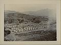 A camp of the British Indian Army near the Khyber Pass (c. 1920)
 -
 Mountain passes of Afghanistan
 -

-

-


Cultural references
This section needs additional citations for verification. (October 2017) |
A number of locations around the world have been named after the Khyber Pass:
- A steep and twisting minor road in Mugdock Country Park near Glasgow, Scotland. The road is a landmark along the West Highland Way and is popular among local road cyclists.[15]
- A suburb of Civil Lines, Delhi, India.[16][17][18]
- Khyber Pass Road, a major road in the suburb of Newmarket, Auckland, New Zealand (Google Earth view)
- An artificial rockwork feature at East Park, Kingston upon Hull, UK.[19][20]
- Khyber Road in Phoenix Park, Dublin, Ireland.[21]
- A steep and twisting road up the West Cliff at Whitby, UK.
- A pedestrian alley in Stromness, Orkney, Scotland[22]
- Khyber Pass Pub in Philadelphia, Pennsylvania.
- Khyber Himalayan Resort and Spa in Gulmarg, Jammu and Kashmir.
- A mountain bike trail connecting the Top of the World trail at Whistler, British Columbia to the Whistler Creekside Village.[citation needed]
- A subway in the King's Cross St Pancras tube station. After the King's Cross fire in November 1987, it was replaced.[23]
Other references include the following:
- The bus journey on this road was belle-lettered very beautifully, and a part of its first act, in the selective memoir Deshe Bideshe (1948) by Syed Mujtaba Ali.
- Before the partition of India, the pass was mentioned as part of common Hindustani phrase used to describe the length of colonial India, "Khyber sé Kanyakumari".[8]
- 'Khyber Pass' is Cockney rhyming slang meaning 'arse'. This use is alluded to in the 1968 film Carry On Up the Khyber.
- In the 1975 movie The Man Who Would Be King, the character Peachy Carnehan tells Rudyard Kipling how he and his comrade-in-arms Danny Dravot had fought under Frederick Roberts, 1st Earl Roberts yard by yard through the Khyber Pass during the Second Anglo-Afghan War of 1878-1880
- The podcast Twilight Histories has an episode called "Napoleon in Afghanistan" which partly takes place in the Khyber Pass.[citation needed]
- The Vampire Weekend song "M79" references the Khyber Pass.
- The Tom Cochrane song "Life Is a Highway" (covered by Rascal Flatts and others) references the Khyber Pass.
- The album Rio Grande Blood by Ministry (2006) has a song called "Khyber Pass" which references it as a possible hiding place for then missing and at large Osama bin Laden. This song was also featured at the end of the film The Hurt Locker.
- The song "Red War" by Probot, featuring Max Cavalera on vocals, mentions the pass.
- British rock band Up the Khyber", featured on the soundtrack to the film More.
- In an episode of the cartoon series The World of Commander McBraggtitled “Khyber Pass”, the eponymous commander has to fend off ten thousand screaming tribesmen in the Khyber Pass.
- Parts of the 1985 Jay McInerney book Ransom take place in or near the Khyber Pass.
- The Khyber pass features in several of Rudyard Kipling's poems: it appears by name in "The Ballad of the King's Jest",[24] as "the Pass" in "Arithmetic on the Frontier",[24] and semi-fictionalized as the Tongue of Jagai in "The Ballad of East and West".[25]
- In the 2023 movie Ghosted the farmer Cole played by Chris Evans is abducted to the Khyber Pass and rescue by CIA operative Sadie played by Ana de Armas as showned by the location card at 35'15", but the film was actually filmed in New Mexico.[26][27]
See also
- Ali Masjid
- Bab-e-Khyber
- Battle of Ali Masjid
- Battle of Khyber Pass
- Bolan Pass
- Carry On... Up the Khyber, film
- Dasht-e Yahudi
- Dorah Pass
- Durand Line
- Khyber Agency
- Khyber Pass Copy
- Khyber Pass Railway
- Khyber Pass Economic Corridor
- Khyber Rifles
- Khyber train safari
References
- ^ Wright, Colin. "Maliks of Khyber Pass". www.bl.uk. Retrieved 2023-03-07.
- ^ a b c d e f g h i j k l m n o Wilde, Andreas (September 27, 2022). "KHYBER PASS". Brill – via referenceworks.brillonline.com.
- ISBN 9781108009416. Retrieved 28 March 2017.
- ISBN 9781786716996.
- ISBN 9781135933739.
- ^ ISBN 978-1-4027-5696-2.
- ISBN 978-81-7304-785-5.
- ^ a b Rajghatta, Chidanand (27 June 2017). "Attock to Cuttack, PM Narendra Modi causes a stir". The Economic Times. Retrieved 23 June 2020.
- ^ "Introducing The Khyber Pass". Lonelyplanet.com. 2009-03-24. Archived from the original on 2011-06-07. Retrieved 2010-11-12.
- ^ Oppel Jr, Richard A. (2 January 2009). "Pakistan Briefly Reopens Key NATO Supply Route". The New York Times. Archived from the original on 20 May 2013. Retrieved 18 June 2012.
- ^ "Pakistan and Afghanistan". Institute for the Study of War. Archived from the original on 9 February 2012. Retrieved 18 June 2012.
- ^ "Pakistan Reopens Khyber Pass To US/NATO". Archived from the original on 24 July 2012. Retrieved 18 June 2012.
- ^ Karin Brulliard (October 9, 2010). "Pakistan reopens border to NATO supply trucks". Washington Post Foreign Service. Archived from the original on 9 February 2011. Retrieved 18 June 2012.
- ^ Ahmad Nabi (August 17, 2011). "Nato supplies via Khyber Pass halted due to security". Archived from the original on 11 January 2012. Retrieved 18 June 2012.
- ^ "Khyber Pass Trail at Mugdock Park". Trailforks. Retrieved 2020-03-30.
- ^ Khyber Pass Map Archived 2011-10-30 at the Wayback Machine. Mapsofindia.com (2013-03-01). Retrieved on 2013-07-12.
- ^ "Khyber Pass Delhi". Google Maps. Retrieved 2013-07-12.
- ^ "MGF City , Khyber Pass , North Delhi". Archived from the original on 2012-03-10. Retrieved 2011-05-19.
- ^ "East's Eden". Kingston upon Hull City Council. September 2002. Archived from the original on 2013-05-17.
- ^ Historic England. "Details from listed building database (1001519)". National Heritage List for England. Retrieved 14 January 2013.
- ^ McNally, Frank (20 February 2013). "An Irishman's Diary". The Irish Times. Retrieved 2 May 2021.
- ^ "OpenStreetMap". OpenStreetMap. Retrieved 2019-08-07.
- ^ "New subway to replace Kings Cross "Khyber Pass"". This Is Local London. 12 August 2004.
- ^ a b National Geographic Society (2011-11-21). "The Khyber Pass". National Geographic Society. Archived from the original on 2019-08-07. Retrieved 2019-08-07.
- ^ "The Ballad of East and West". www.kiplingsociety.co.uk. Archived from the original on 2019-08-22. Retrieved 2019-08-07.
- ^ "Where was 'Ghosted' filmed? All 'Ghosted' filming locations". 21 April 2023. Retrieved 2023-04-27.
- ^ "Where was Ghosted filmed?". Retrieved 2023-04-27.
Further reading
- OCLC 7233999.
External links
 Definitions from Wiktionary
 Media from Commons
 News from Wikinews
 Quotations from Wikiquote
 Texts from Wikisource
 Textbooks from Wikibooks
 Resources from Wikiversity
 Travel information from Wikivoyage
| History | |
|---|---|
| Government |
|
| Culture and places |
|
| Geography |
|
| Education & Health |
|
| Sport |
|