Killiecrankie
Killiecrankie
| |
|---|---|
 Killiecrankie | |
Location within Perth and Kinross | |
| OS grid reference | NN913628 |
| Civil parish | |
| Council area | |
| Country | Scotland |
| Sovereign state | United Kingdom |
| Police | Scotland |
| Fire | Scottish |
| Ambulance | Scottish |
| UK Parliament | |
| Scottish Parliament | |

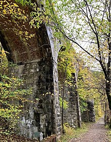
Killiecrankie (Tummel Hydro-Electric Power Scheme. Much of the riverbank is owned by the National Trust for Scotland. The nearby 10 arch railway viaduct, which runs for 109 yards (100 m) along the north-east bank of the River Garry,[2] was built in 1863 from a design by Joseph Mitchell.
History
In 1689, during the
Braes o' Killiecrankie, commemorates the battle. A 1966 recording by The Corries was a pioneering use of the music video
.


According to official records, the last wolf in Great Britain was killed near Killiecrankie in 1680.[4]
Television
Mary Ann Kennedy was the presenter of a BBC Four television series The Highland Sessions, which was filmed in Killiecrankie. Many notable musicians and singers from Ireland and Scotland performed in the sessions.[5]
References

- ISBN 978-0-319-23119-7
- ISBN 978-1-84033-929-1.
- ^ "Urrard House". Historic Scotland. Retrieved 24 July 2013.
- ^ Shoberl, Frederic (1834). Natural History of Quadrupeds. J. Harris.
- ^ "The Highland Sessions". All Celtic Music. Retrieved 17 December 2010.
External links
Wikimedia Commons has media related to Killiecrankie.
- Chisholm, Hugh, ed. (1911). . Encyclopædia Britannica. Vol. 15 (11th ed.). Cambridge University Press. p. 795.

