
King Street, Hammersmith

King Street, Hammersmith is the main shopping street in
The street is two-way along its western part, and one-way westbound along its eastern part. Eastbound traffic uses Studland Street, Glenthorne Road and Beadon Road.
History

Despite the name, and its proximity to
The street is about a mile and a half long, and formerly had several posting-houses, as it was the road to Windsor, which have now become pubs. It has long been the principal street of Hammersmith.[2]
On 26 January 2018, a water main in King Street burst, flooding the street. 70 people were led to safety by the London Fire Brigade.[3]
Notable buildings
Several of the pubs along King Street are
On the north side, there is the
Also on the north side, at Nos. 238–246, is the
On the south side of King Street is Hammersmith Town Hall. Originally set further back from the street, in the 1970s a huge concrete extension was built facing the street, on the site of a former park, to accommodate offices. In 2013 the go-ahead was given to demolish the 'eyesore' and replace it with a new green space and homes.[6]
Also on the south side of King Street is Rivercourt Methodist Church, built in 1875 by Charles Bell. Next door, at No. 237, is Latymer Upper School, a co-educational independent school, founded in 1895 and the descendant of a school founded in the seventeenth century by Edward Latymer who, by his will, dated 1624, bequeathed thirty-five acres of land in Hammersmith, "the profits of which were to be appropriated to clothing six poor men, clothing and educating six poor boys, and distributing in money."[2] Toby Young's West London Free School in Pallingswick House sits on the corner of King Street and Weltje Road.
-
 The Salutation
 -
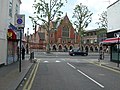
 Kings Mall shopping centre
 -
 Sam's Chicken, King Street, Hammersmith
 -
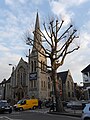 Rivercourt Methodist Church
 -
 Latymer Upper School
 -
 The Polish Social and Cultural Association in London
 -
 Gate into Ravenscourt Park on King Street
.jpg)


References
- ^ "HUC History". Hammersmith United Charities. Retrieved 2 April 2016.
- ^ a b "Hammersmith". British History Online. Retrieved 29 March 2016.
- ^ "Hammersmith flood: Scores evacuated from streets as flash floods hit wide stretch of West London". The Independent. 27 January 2018. Retrieved 27 January 2018.
- ^ "King's Mall Shopping Centre". Official website.
- ^ "Ravenscourt Park". London Gardens Online. Retrieved 30 March 2016.
- ^ "Demolition of eyesore Hammersmith Town Hall given go-ahead". Evening Standard. 19 November 2013. Retrieved 29 March 2016.