
Kirovohrad Oblast
Kirovohrad Oblast
Кіровоградська область | |
|---|---|
| Kirovohradska oblast[1] | |
|
UP10 | |
| Website | kr-admin.gov.ua |
Kirovohrad Oblast (
In 2019, the Constitutional Court of Ukraine approved the change of the oblast's name to Kropyvnytskyi Oblast (Ukrainian: Кропивницька область, romanized: Kropyvnytska oblast, unofficially Kropyvnychchyna (Ukrainian: Кропивниччина)).[4] The change is not yet implemented. The largest cities of the region are Kropyvnytskyi, Oleksandriia, Znamianka and Svitlovodsk.
Geography
The area of the province is 24,600 square kilometres (9,500 sq mi).
The city of Dobrovelychkivka is the geographical center of Ukraine.
History
In the 1800s, majority of the landed was owned by the noble
The oblast was created as part of the Ukrainian SSR on January 10, 1939 out of the northern raions of Mykolaiv Oblast. Before establishment, its territory was part of Kherson Governorate (most of it) and Podolia Governorate (smaller portion) until 1925. Earlier before occupation of Ukraine in 1920s, in 1918 there were plans to introduce own Ukrainian administrative territorial division with territory of modern Kirovohrad Oblast being split between lands of Nyz (Lower land), Pobozhia (Boh land), and Cherkasy.
In 1954, the oblast lost some raions to the newly created Cherkasy Oblast, but later that year received its western raions from the Odesa Oblast.
Between 1939 and 2016, the oblast administrative center, Kropyvnytskyi, was called Kirovohrad and was named after the First Secretary of the
On 20 June 2018, the Committee on State Building, Regional Policy and Local Self-Government of the
Points of interest
The following sites were nominated for the Seven Wonders of Ukraine:
- Khutir Nadiia, outskirts of Mykolaivka village
Administrative divisions

| Kirovohrad Oblast | |
| As of January 1, 2022 | |
| Number of districts (райони) | 4 |
| Number of hromadas (громади) | 49 |
| No. | Name | Coat of arms | Population, (2020). |
Area, km² |
Density, per km² |
Administrative center |
Map | Subdivisions |
|---|---|---|---|---|---|---|---|---|
| 1 | Holovanivsk | 
|
122,952 | 4,244 | 28.97 | Holovanivsk | 
|
10 hromadas |
| 2 | Kropyvnytskyi | 
|
442,997 | 9,709 | 45.62 | Kropyvnytskyi | 
|
17 hromadas |
| 3 | Novoukrainka | 
|
140,539 | 5,196 | 27 | Novoukrainka | 
|
13 hromadas |
| 4 | Oleksandriya
|

|
226,721 | 5,405 | 41.94 | Oleksandriya
|

|
9 hromadas |
Before the
Demographics
Language
According to the 2001 Ukrainian census, Ukrainian was the mother tongue of 88.9% of the population, for 10.0% it was Russian, and for 1.1% it was another language.
According to a survey "Is the language (ir)relevant?" (Ukrainian: "Мова (не) на часі?"), which took place in Kirovohrad Oblast from 12 to 22 October 2023, 96.7% of respondents named Ukrainian as their mother tongue, while 2.6% named Russian as their mother tongue. In everyday life, 66.4% of respondents spoke Ukrainian, 29.4% spoke Surzhyk, and 3.4% spoke Russian.[15]
Age structure
- 0-14 years: 14.3%
 (male 72,646/female 68,970)
 - 15-64 years: 68.7%
 (male 324,698/female 355,058)
 - 65 years and over: 17.0%
 (male 55,718/female 111,666) (2013 official)
Median age
- total: 41.2 years
- male: 37.7 years
- female: 44.5 years (2013 official)
Nomenclature
Most of Ukraine's oblasts are named after their
Gallery
-
 Hospital in Novomyrhorod
 -
 Former hospital in Nova Praha
 -
 Khutir Nadiia museum
 -
 Cathedral of Nativity of Mary in Kropyvnytskyi
 -
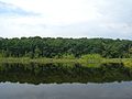
 Near Inhul River
 -
 Panski Hory landscape reserve
 -
 Confluence of Berezivka and Inhul rivers
 -
 Black Forest
,_01.jpg)
.jpg)

.jpg)


See also
References
- )
- ^ a b Чисельність наявного населення України на 1 січня 2022 [Number of Present Population of Ukraine, as of January 1, 2022] (PDF) (in Ukrainian and English). Kyiv: State Statistics Service of Ukraine. Archived (PDF) from the original on 4 July 2022.
- ^ "Валовии регіональнии продукт".
- ^ "The Opinion of the Constitutional Court of Ukraine in the case of renaming the Kirovohrad oblast is given". Українське право - інформаційно-правовий портал. 5 February 2019.
- ^ "Скаржинские". 21 February 2011.
- ^ "Ольгинская сельскохозяйственная школа /Ольгинско-Скаржинская сельскохозяйственная школа, Ольгинско-Скаржинское сельскохозяйственное училище/". 31 October 2012.
- ^ Ukrayinska Pravda(14 July 2016)
- ^ Ukraine, The World Factbook
- UNIAN(20 June 2018)
- ^ "Надано Висновок Конституційного Суду України в справі щодо перейменування Кіровоградської області | Конституційний Суд України". www.ccu.gov.ua. Retrieved 2019-06-13.
- ^ "Constitutional Court Declares Bill Renaming Kirovohrad Region As Kropyvnytskyi Region Constitutional". ukranews.com. 2019-02-06. Retrieved 2019-06-13.
- ^ "Перейменування Кіровоградської області - звернення до ВРУ". Suspilne (in Ukrainian). 2021-03-30.
- ^ Купюр, Без (2021-04-22). "Верховна Рада відреагувала на звернення про перейменування Кіровоградщини формально | Без Купюр - Новини Кропивницького і Кіровоградщини". Без Купюр (in Ukrainian). Retrieved 2023-02-04.
- ^ "Кіровоградська облрада закликала Верховну Раду пришвидшити перейменування області". hromadske.ua (in Ukrainian). 2022-09-21. Retrieved 2023-02-04.
- ^ https://suspilne.media/603693-za-cas-vijni-stavlenna-ukrainciv-do-derzavnoi-movi-pomitno-zminilosa-dani-opituvanna-sodo-movi-na-kirovogradsini/ [bare URL]
External links
- "Main". Official web-site of the Kirovohrad Oblast State Administration (in Ukrainian). Archived from the original on 13 August 2006. Retrieved 7 April 2014.
| International | |
|---|---|
| National | |
| Geographic | |
| Other | |