
Kitay-gorod
This article needs additional citations for verification. (August 2012) |
You can help expand this article with text translated from the corresponding article in Russian. (August 2019) Click [show] for important translation instructions.
|

Kitay-gorod (Russian: Китай-город, IPA: [kʲɪˈtaj ˈɡorət]), also referred to as the Great Possad (Великий Посад) in the 16th and 17th centuries, is a cultural and historical area within the central part of Moscow in Russia, defined by the remnants of now almost entirely razed fortifications, narrow streets and very densely built cityscape. It is separated from the Kremlin by the Red Square. Kitay-gorod does not constitute a district (raion), as there are no resident voters, thus, municipal elections are not possible. Rather, the territory has been part of Tverskoy District, and the Central Administrative Okrug authorities have managed the area directly since 2003.
Destruction during the Soviet era
All 10 chapels, 7 out of 18 parish churches, the Cathedral of the Nikolo-Greek Monastery, and two monastery bell towers were demolished in Kitay-gorod in the 1920s and 1930s by the Soviet government. After the destruction of the ancient wall with fortress towers, Kitay-gorod lost its borders and outlines. And in the mid-30s, with the renaming of the main streets after communist revolutionaries and politicians, the ancient toponymy of Kitay-gorod was also destroyed. The last pre-war victim of Kitay-gorod was the Kazan Cathedral, demolished in 1936, which stood on the corner of Nikolskaya Street and the Red Square.
Starting from 1990, the original names of the streets were restored, but most of the cultural heritage cannot be rebuilt.[1]
Etymology
Beside Kitay-gorod in
Kita (pl. kity) is a somewhat obsolete word for "plait" or "an item made by braiding". A 17th-century Russian source states "У шапок янычары имели киты" ("U shapok yanychary imeli kity"), meaning "The Janissaries had braids hanging from their caps". In his 1967 book Rise of Russia, author Robert Wallace asserts that the term might mean a rough-hewn defensive bulwark made from woven wicker baskets filled with earth or rock – and thus Kitay-gorod means "Basket city". Kitay could also be derived from an old word for the wooden stakes used in construction of the quarter's walls. Gorod is simply the Russian word for "city", derived from the ancient gord.
Kitay (Russian: Китай) is also the modern Russian name for China, and cognates with the historic Khitan people of northeastern China. Kitay cognates with the English Cathay.
Walls

The walls were erected from 1536 to 1539 by an Italian architect known under the Russified name Petrok Maly and originally featured 13 towers and six gates. All of the towers were demolished in the 1930s by the Soviet regime as part of Stalin's grand reconstruction of Moscow, with only small portions of the wall surviving that period. City officials plan to close Kitay-gorod to automobile traffic. Since 1995 the wall has been partially rebuilt, and a new tower has been added.
Squares
Apart from the
Architecture

Kitay-gorod, developing as a trading area, was known as a business area of Moscow. Its three main streets—Varvarka, Ilyinka, and Nikolskaya—are lined with banks, shops, and storehouses like the historicistic shopping mall GUM which confines Kitay-gorod towards Red Square.

St. Nicholas Church on the Ilyinka (1680–89), informally known as the Great Cross, was a landmark in Kitay-gorod but was destroyed in 1933 on Stalin's orders.[3] This district also features the Church of Cosmas and Damian and the Trinity Church of Nikitniki, which today is nestled among city buildings. It was built in the 1630s on the land of Moscow merchant, Grigory Nikitnikov.[4]
Nikolskaya Street is the site of Moscow's first university, the
In the 19th century, Red Square was lined by a

Also in the 1890s, developers consolidated large land lots on the perimeter of Kitay-gorod.
The present-day offices and clock tower of
Zaryadye

A whole quarter of Kitay-gorod
Gallery
-
 A 1922 painting by A. Vasnetsov, depicting a street in Kitay-gorod in the 17th century
 -
 A. Vasnetsov. Spasskiye/Wodyaniye (Savior/Water) gates of Kitay-gorod in the 17th century
 -
 Nikolskiye (St. Nikolay's) Gates and breaching gates, c. 1800
 -
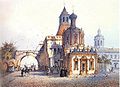
 Novaya square, c. 1800
 -
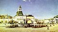
 Ilyinskye (St. Elijah's) gates, 1840s
 -
 Nikolskiye/Vladimirskiye (St. Nikolay's/St. Vladimir's) Gates, 1840s
 -
 Varvarskye (St. Barbara's) gates, 1880s
 -
 Nikolskiye/Vladimirskiye Gates andLubianka Square, 1880
 -
 Kitay-gorod wall in the 1920s
 -
 Kitai-gorod wall in Zaryadye, 1934
 -
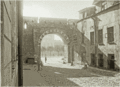 Breaching gates in Zaryadye, 1934
 -
 The Old English Court
 -
 Old map of the Kitay-gorod showing the walls in black


.jpg)

References
- ^ Трагедия Китай-города: The Tragedy of Kitay Gorod
- ^ Grand duchy of Moscow, page 115, Gustav Kiepenheuer Verlag Weimar
- ^ "St. Nicholas Church Ilyinka". St. Nicholas Center.
- ^ "The Church of the Holy Trinity in Nikitniki".
- ^ "Kitay-gorod is a historical part of Moscow". 7 July 2016.