
Klein Curaçao
Country Curaçao | | |
| Demographics | ||
|---|---|---|
| Population | 0 | |
| Official name | Klein Curaçao | |
| Designated | 31 July 2018 | |
| Reference no. | 2355[1] | |
| Klein Curaçao Lighthouse | ||
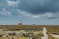
| Constructed | 1850 (first) 1879 (rebuilt) | |
| Construction | masonry tower | |
| Height | 20 m (66 ft) | |
| Shape | cylindrical tower with balcony and lantern[2][3][4] | |
| Markings | white tower, red lantern | |
| Power source | solar power | |
| First lit | 1913 (rebuilt) | |
| Focal height | 25 m (82 ft) | |
| Range | 15 nmi (28 km; 17 mi) | |
| Characteristic | Fl(2) W 15s | |
Klein Curaçao (English: Little Curaçao) is a 1.7-square-kilometre (170 ha; 0.66 sq mi) uninhabited island belonging to, and lying 10 km south-east of, Curaçao, a constituent country of the Kingdom of the Netherlands in the Dutch Caribbean.
Description
Klein Curaçao has a desert climate (in the
day trippers from Curaçao, and apart from some coconut palms has little vegetation. There are some fishermen's huts where fishermen normally stay for some days. They get water from the Coast Guard of Curaçao. The windward side is a graveyard for boats that did not stay out far enough or lost power. A small tanker, the Maria Bianca Guidesman, is gradually being demolished by the constant pounding of the waves since 1988.[5]
The remains of another four or five boats have been washed far onshore. As with Curaçao, hurricanes are few, but several storms have left their mark; the 1877 hurricane destroyed the first lighthouse. The next lighthouse, which still survives, was built in the interior of the island.
History
The island played a part in the
extinct Caribbean monk seals on Klein Curaçao. In 1871, John Godden, an English mining engineer, visited the island, discovering there was a significant vein of phosphate
on the island. From 1871 onward until 1886, the Dutch government set up mining operations on the island, with phosphate being mined and exported to Europe.
Environment
Once the phosphate was mined out, the level of the island dropped, and seabird populations plummeted.
Goats were once allowed to roam the island, which contributed to its desertification. The goats were eradicated in 1996, as were feral cats by 2004.[6] Reforestation is being undertaken by CARMABI Marine Research Station, Curaçao. The island was designated as a protected Ramsar site in 2018.[1] It has also been identified as an Important Bird Area by BirdLife International as a nesting site for least terns, while its shores are used seasonally by large numbers of migratory waders. With the elimination of the goats and cats, the island has the potential to become an important seabird nesting location. Hawksbill, loggerhead and green sea turtles nest on the island's beaches.[6]
Gallery
-
 Location of Klein Curaçao
 -
 Klein Curaçao lighthouse
 -
 Maria Bianca Guidesman aerial view
 -
 Klein Curaçao beach
 -
 Klein Curaçao
 -
 Klein Curaçao lighthouse
 -
 Maria Bianca Guidesman Shipwreck
 -
 Beach at Klein Curaçao

.jpg)
.jpg)
.jpg)
.jpg)
.jpg)


See also
References
- ^ a b "Klein Curaçao". Ramsar Sites Information Service. Retrieved 6 September 2018.
- ^ michaeljohngrist.com
- ^ Rowlett, Russ. "Lighthouses of Curaçao". The Lighthouse Directory. University of North Carolina at Chapel Hill. Retrieved 2016-09-06.
- ^ List of Lights, Buoys and Fog Signals Atlantic Coast. Retrieved 6 September 2016
- ^ Bianca Marie (Fundación Histarmar − Historia y Arqueología Marítima, Retrieved 11 May 2020.)
- ^ a b "Klein Curaçao, Curaçao". BirdLife Data Zone. BirdLife International. 2007. Retrieved 19 October 2020.
Wikimedia Commons has media related to Klein Curaçao.
| ||
| Authority control databases: Klein Curaçao Lighthouse |
|
|---|