
Kołobrzeg
Kołobrzeg
Kòlbrzég (Kashubian) | ||
|---|---|---|
Coastline of the Baltic Sea in Kołobrzeg and historical lighthouse. | ||
|
Car plates ZKL | | |
| Website | www | |
_by_Klugschnacker_in_Wikipedia.jpg)
_by_Klugschnacker_in_Wikipedia.jpg)

Kołobrzeg (Polish:
During the
In the late 19th century Kolberg became a popular spa town at the Baltic Sea. In 1945, Polish and Soviet troops captured the town, while the remaining German population which had not fled the advancing
Etymology
"Kołobrzeg" means "by the shore" in Polish; "koło" translates as "by"[1] and "brzeg" means "coast" or "shore".[2] Kashubian: Kòłobrzeg has a similar etymology. The original name of Cholberg was taken by Polish and Kashubian linguists in the 19th and 20th centuries to reconstruct the name. After German settlement, the original name of Cholberg evolved into German: Kolberg ([ˈkɔlbɛʁk] ⓘ).
History
Pomeranian stronghold at modern Budzistowo
According to Piskorski (1999) and Kempke (2001), Slavic and Lechitic immigration reached Farther Pomerania in the 7th century.[3][4] First Slavic settlements in the vicinity of Kołobrzeg were centered around nearby deposits of salt and date to 6th and 7th century.[5][6]
In the late 9th century, the
The
In the 9th and 10th centuries, the Budzistowo stronghold was the largest of several smaller ones in the Persante area, and as such is thought to have functioned as the center of the local
Piast Poland and conversion

During
The missionary efforts of bishop
During his campaigns in the early 12th century,
During the subsequent
Besides St. Mary's, a St. John's church and a St. Petri's chapel were built.[13] A painting of the town of Kołobrzeg from the 13th century is located in the Museum of Polish Arms in the city.[27]
From the late Middle Ages to the Thirty Years' War


During the
Henceforth, the nearby former stronghold was turned into a village and renamed "Old Town" (

Already in 1248, the
In 1361, the city joined the Hanseatic League. In 1446 it fought a battle against the nearby rival city of Koszalin.[36]
When the property of the
In the 15th century the city traded with Scotland, Amsterdam and Scandinavia.[18] Beer, salt, honey, wool and flour were exported, while merchants imported textiles from England, southern fruits, and cod liver oil. In the 16th century, the city reached 5,000 inhabitants.[18] The indigenous Slavs in the city were discriminated, and their rights in trade and crafts were limited, with bans on performing certain types of professions and taking certain positions in the city,[18][citation needed] for instance in 1564 it was forbidden to admit native Slavs to the blacksmiths' guild.[37]
During the Thirty Years' War, Kolberg was occupied by imperial forces from 1627 to 1630,[38] and thereafter by Swedish forces.[39]
Modern era: In Prussia
Kolberg, with most of


During
In the 19th century the city had a small but active Polish population that increased during the century to account for 1.5% of the population by 1905.[43] The Polish community funded a Catholic school and the Church of Saint Marcin where masses in Polish were held (initially throughout the season, after about 1890 all the year), were established.[6][44][45] Dating back to 1261 Kolberg's Jewish population amounted to 528 people in 1887, rising to 580 two years later, and although many moved to Berlin after that date they numbered around 500 by the end of the Nineteenth century[46]

Between 1924 and 1935, the American-German painter
In the May elections of 1933, the Nazi Party received by far the most votes, 9,842 out of 19,607 cast votes.[47]
When the Nazis took power in Germany in 1933, the Jewish community in Kolberg comprised 200 people, and the antisemitic repression by Germany's ruling party led several of them to flee the country. A Nazi newspaper, the Kolberger Beobachter, listed Jewish shops and business that were to be boycotted. Nazis also engaged in hate propaganda against Jewish lawyers, doctors, and craftsmen.[48] At the end of 1935, Jews were banned from working in the city's health spas.[48] During Kristallnacht, the Jewish synagogue and homes were destroyed, and in 1938 the local Jewish cemetery was vandalised, while a cemetery shrine was turned to stable by German soldiers.[49] In 1938, all Jews in Kolberg, as all over Germany, were renamed in official German documents as "Israel" (for males) or "Sarah" (for females). In the beginning of 1939, Jews were banned from attending German schools and the entire adult population had its driving licenses revoked.[48] After years of discrimination and harassment, local Jews were deported by the German authorities to concentration camps in 1940.
Second World War

During the
In 1944, the city was selected as a fortress — Festung Kolberg. The 1807 siege was used for the last Nazi propaganda film, Kolberg shortly before the end of the war by Joseph Goebbels. It was meant to inspire the Germans with its depiction of the heroic Prussian defence during the Napoleonic Wars. Tremendous resources were devoted to filming this epic, even diverting tens of thousands of troops from the front lines to have them serve as extras in battle scenes. Ironically, the film was released in the final few weeks of Nazi Germany's existence, when most of the country's cinemas were already destroyed.
On 10 February 1945, the German torpedo-boat T-196 brought about 300 survivors of the General von Steuben, which had been sunk by Soviet submarine S-13 to Kolberg. As the Red Army advanced on Kolberg, most of the inhabitants and tens of thousands of refugees from surrounding areas (about 70,000 were trapped in the Kolberg Pocket), as well as 40,000 German soldiers, were evacuated from the besieged city by German naval forces in Operation Hannibal. Only about two thousand soldiers were left on 17 March to cover the last sea transports.
Between 4 and 18 March 1945, there were
After the battle the city for several weeks was under Soviet administration, the Germans that had not yet fled were
- Before, during, and after the war
-
 Kolberg between 1890 and 1905
 -
 Strandschloss (Beach Castle) in Kolberg c. 1900
 -
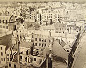 80% of the city destroyed in 1945
 -
 Ratuszowy Square, Kołobrzeg in 2019


Post-war Poland

After
In 2000 the city business council of Kołobrzeg commissioned a monument called the Millennium Memorial as a commemoration of "
Climate
Kołobrzeg has an oceanic climate (Köppen climate classification: Cfb).[51][52]
| Climate data for Kołobrzeg (1991–2020 normals, extremes 1951–present) | |||||||||||||
|---|---|---|---|---|---|---|---|---|---|---|---|---|---|
| Month | Jan | Feb | Mar | Apr | May | Jun | Jul | Aug | Sep | Oct | Nov | Dec | Year |
| Record high °C (°F) | 15.3 (59.5) |
17.8 (64.0) |
23.2 (73.8) |
28.9 (84.0) |
31.7 (89.1) |
35.9 (96.6) |
35.7 (96.3) |
38.0 (100.4) |
32.3 (90.1) |
26.1 (79.0) |
19.5 (67.1) |
14.3 (57.7) |
38.0 (100.4) |
| Mean maximum °C (°F) | 9.1 (48.4) |
10.3 (50.5) |
15.9 (60.6) |
22.3 (72.1) |
26.7 (80.1) |
28.9 (84.0) |
30.0 (86.0) |
30.2 (86.4) |
24.8 (76.6) |
19.1 (66.4) |
13.2 (55.8) |
9.9 (49.8) |
32.4 (90.3) |
| Mean daily maximum °C (°F) | 2.9 (37.2) |
3.8 (38.8) |
6.8 (44.2) |
11.8 (53.2) |
15.9 (60.6) |
19.3 (66.7) |
21.7 (71.1) |
22.0 (71.6) |
18.1 (64.6) |
12.9 (55.2) |
7.5 (45.5) |
4.1 (39.4) |
12.2 (54.0) |
| Daily mean °C (°F) | 0.7 (33.3) |
1.2 (34.2) |
3.4 (38.1) |
7.6 (45.7) |
11.8 (53.2) |
15.6 (60.1) |
17.9 (64.2) |
17.9 (64.2) |
14.1 (57.4) |
9.5 (49.1) |
5.1 (41.2) |
2.0 (35.6) |
8.9 (48.0) |
| Mean daily minimum °C (°F) | −1.5 (29.3) |
−1.1 (30.0) |
0.7 (33.3) |
4.2 (39.6) |
8.1 (46.6) |
11.8 (53.2) |
14.2 (57.6) |
14.1 (57.4) |
10.8 (51.4) |
6.7 (44.1) |
3.0 (37.4) |
−0.2 (31.6) |
5.9 (42.6) |
| Mean minimum °C (°F) | −10.4 (13.3) |
−8.5 (16.7) |
−5.3 (22.5) |
−1.2 (29.8) |
2.4 (36.3) |
7.0 (44.6) |
10.1 (50.2) |
9.2 (48.6) |
5.2 (41.4) |
0.3 (32.5) |
−3.4 (25.9) |
−7.5 (18.5) |
−13.2 (8.2) |
| Record low °C (°F) | −23.9 (−11.0) |
−25.5 (−13.9) |
−17.7 (0.1) |
−5.5 (22.1) |
−2.6 (27.3) |
0.0 (32.0) |
4.4 (39.9) |
2.4 (36.3) |
−0.7 (30.7) |
−5.5 (22.1) |
−13.1 (8.4) |
−18.3 (−0.9) |
−25.5 (−13.9) |
| Average precipitation mm (inches) | 48.2 (1.90) |
40.5 (1.59) |
42.9 (1.69) |
34.0 (1.34) |
50.6 (1.99) |
70.4 (2.77) |
77.0 (3.03) |
89.9 (3.54) |
73.2 (2.88) |
64.9 (2.56) |
51.0 (2.01) |
55.0 (2.17) |
697.7 (27.47) |
| Average extreme snow depth cm (inches) | 4.7 (1.9) |
5.0 (2.0) |
3.0 (1.2) |
0.2 (0.1) |
0.0 (0.0) |
0.0 (0.0) |
0.0 (0.0) |
0.0 (0.0) |
0.0 (0.0) |
0.2 (0.1) |
1.3 (0.5) |
3.4 (1.3) |
5.0 (2.0) |
| Average precipitation days (≥ 0.1 mm) | 17.67 | 15.69 | 14.00 | 11.07 | 12.80 | 13.13 | 14.00 | 14.07 | 13.70 | 15.60 | 16.20 | 18.77 | 176.69 |
| Average snowy days (≥ 0 cm) | 9.3 | 9.2 | 3.9 | 0.1 | 0.0 | 0.0 | 0.0 | 0.0 | 0.0 | 0.1 | 1.5 | 5.7 | 29.8 |
| Average relative humidity (%)
|
85.1 | 83.7 | 81.4 | 77.0 | 77.6 | 77.2 | 79.3 | 79.5 | 81.8 | 84.3 | 87.1 | 86.9 | 81.7 |
| Mean monthly sunshine hours | 42.7 | 66.8 | 127.8 | 198.9 | 255.6 | 253.0 | 255.1 | 236.5 | 163.3 | 104.9 | 47.9 | 30.6 | 1,783.1 |
| Source 1: Institute of Meteorology and Water Management[53][54][55][56][57][58][59][60] | |||||||||||||
| Source 2: Meteomodel.pl (records, relative humidity 1991–2020)[61][62][63] | |||||||||||||
Demographics
Before the end of World War II the town was predominantly German Protestant with small Polish and Jewish minorities. Almost all of the pre-war German population fled or was expelled so that since 1945, Polish Catholics make up the majority of the population. Around the turn from the 18th to the 19th century an increase of the number of Catholics was observed, because military personnel had been moved from West Prussia to the town.[citation needed]


| Year | Inhabitants |
|---|---|
| 1740 | 5,027 |
| 1782 | 4,006 |
| 1794 | 4,319 |
| 1812 | 5,597 |
| 1816 | 5,210 |
| 1831 | 6,221 |
| 1843 | 7,528 |
| 1852 | 8,658 |
| 1861 | 10,082 |
| 1900 | 20,200 |
| 1925 | 30,115 |
| 1940 | 36,800 |
| 1945 | approx. 3,000 |
| 1950 | 6,800 |
| 1960 | 16,700 |
| 1975 | 31,800 |
| 1990 | 45,400 |
| 2002 | 47,500 |
| 2004 | 45,500 |
| 2014 | 46,830 |
Tourist destination
Kołobrzeg today is a popular tourist destination for Poles, Germans and due to the ferry connection to Bornholm also Danish people. It provides a unique combination of a seaside resort, health resort, an old town full of historic monuments and tourist entertainment options (e.g. numerous "beer gardens").

Bike path to Podczele
The town is part of the European Route of Brick Gothic[64] network. A bike path "to Podczele", located along the seaside was commissioned on 14 July 2004. The path extends from Kołobrzeg to Podczele. The path has been financed by the European Union, and is intended to be part of a unique biking path that will ultimately circle the entire Baltic Sea.[65][66] The path was breached on 24 March 2010 due to the encroachment of the sea associated with the draining of the adjacent unique Eco-Park marsh area. The government of Poland has allocated PLN 90,000 to repair the breach, and the path re-opened within a year. It was also extended in 2011 to connected with Ustronie Morskie 8 km (5 mi) to the east.
Oldest oak
South of
Cultural center
Kołobrzeg is also a regional cultural center. In the summer take place – a number of concerts of popular singers, musicians, and cabarets. Municipal Cultural Center, is located in the Park teatralny. Keep under attachment artistic arts, theater and dance. Patron of youth teams and the vocal choir. Interfolk organizes the annual festival, the International Meeting of the folklore and other cultural events. Cinema is a place for meetings Piast Discussion Film Club.
In Kołobrzeg there are many permanent and temporary exhibitions of artistic and historical interest. In the town hall of Kołobrzeg is located Gallery of Modern Art, where exhibitions are exposed artists from Kołobrzeg, as well as outside the local artistic circles. Gallery also conducts educational activities, including organized by the gallery of art lessons for children and young people from schools.
Pier

The Kołobrzeg Pier is currently the second longest pier in the West Pomeranian Voivodeship, after the pier in Międzyzdroje. A jetty positioned on the end of the pier enables small ships to sail for sightseeing excursions.[67]
Museums

In town, there is a museum of Polish weapons (
Transport
Train connections
.JPG)
Kołobrzeg has connections among others to
.Ferry
A seasonal ferry service to Nexø on the Danish island of Bornholm is offered by the catamaran Jantar.[68] The trip takes 15 hours and carries passengers but no cars.
Sport
- SKK Kotwica Kołobrzeg – basketball club, which in the 2000s and 2010s competed in the Polish Basketball League, country's top flight
- Kotwica Kołobrzeg– football club
Notable people

- Petrus Pachius (1579–1641/42) a German Protestant minister, teacher and poet
- Karl Wilhelm Ramler (1725–1798), poet, translator, director at Berlin theater [69]
19th century
- Hermann Plüddemann (1809–1868) a German historical painter
- Ernst Maass (1856–1929) a German classical philologist.
- Magnus Hirschfeld (1868–1935), physician, sociologist and early 20th century Gay rights campaigner
- Paul Oestreich (1878–1959), educator, reformer
- Arnold Zadikow (1884–1943), German-Jewish sculptor
- Hans-Jürgen Stumpff (1889–1968), German general of Luftwaffe, co-signer of unconditional surrender 8 May 1945 in Berlin
- Günther Angern (1893–1943), Wehrmacht general
20th century
- Werner Krüger (1910–2003), German engineer, invented Krueger flap in 1943
- Erika von Brockdorff (1911–1943), German resistance fighter
- Karl-Heinz Marbach (1917–1995), German U-boat commander
- Egon Krenz (born 1937), last communist leader of East Germany
- Christine Lucyga (born 1944), politician
- Joanna Nowicka (born 1966) a Polish archer, competed in four consecutive Summer Olympics from 1988.
- Sebastian Karpiniuk (1972–2010) a Polish politician, an assistant to President of Kołobrzeg, died in plane crash
- Dariusz Trafas (born 1972), athlete, javelin throw national record holder
- Daria Korczyńska (born 1981) a retired track and field sprint athlete
- Robert Szpak (born 1989), athlete, javelin throw, 2008 World Junior Champion
- Maja Hyży (born 1989) a Polish singer, participated in the Eurovision Song Contest 2018
Famous persons connected with the city
- Marcin Dunin (1774–1842) archbishop of Poznań and Gniezno, primate of Poland. Imprisoned in the fortress in the city[42]
- Friedrich Ludwig Jahn, (1778–1852), father of gymnastics, was imprisoned in Kolberg fortress in the 1820s [70][71]
- Adolf von Lützow, (1782–1834) a Prussian officer, served with distinction in the siege of Kolberg in 1807 [72]
- Wiktor Szostalo, (born 1952) sculptor and former Solidarity activist.
- Jan Pogány, (born 1960) classical composer, conductor and cellist.
- Ryszard Kukliński, (1930–2004) colonel and spy for NATO in the Cold War period, attended high school in the city.
International relations
Twin towns – sister cities
Kołobrzeg is
 Bad Oldesloe, Germany
- Barth, Germany
- Berlin Pankow, Germany
 Feodosia, Ukraine
 Follonica, Italy
 Koekelberg, Belgium
 Landskrona, Sweden
 Nexø, Denmark
- Nyborg, Denmark
 Pori, Finland
- Simrishamn, Sweden
See also
Notes
References
- ^ ADIPS Sp. z o.o. "DICT – English Polish Dictionary". Dict.pl. Archived from the original on 18 February 2012. Retrieved 8 July 2009.
- ^ ADIPS Sp. z o.o. "DICT – English Polish Dictionary". Dict.pl. Archived from the original on 18 February 2012. Retrieved 8 July 2009.
- ISBN 978-8390618487.
- ISBN 3-515-07671-9.
- ISBN 83-210-0072-X, p.8
- ^ a b c d [1] Archived 27 September 2009 at the Wayback Machine Historic calendar of the city's Official webpage
- ^ ISBN 3-8305-0378-4
- ^ ISBN 3-406-54986-1
- ISBN 3-515-07671-9
- ISBN 3-8305-0378-4
- ^ ISBN 3-933701-06-6
- ISBN 3-8305-0378-4
- ^ ISBN 3-8305-0378-4
- ISBN 3-8305-0378-4
- ^ a b c [2] Archived 27 December 2010 at the Wayback Machine 'Historical eras' Official webpage of the city: The local Slavic population engaged in fishery, salt trade and various crafts.
- ISBN 3-8305-0378-4
- ^ ISBN 3-8305-0378-4
- ^ a b c d e f g h i j k l m n o p q r s t "Epoki Historyczne". Miasto Kołobrzeg (in Polish). Retrieved 21 March 2020.
- ISBN 978-0-521-87616-2
- ISBN 978-0-7190-4926-2
- ISBN 978-3-05-003749-3
- ISBN 978-3-515-07498-8
- ISBN 3-8305-0378-4
- ^ ISBN 3-8305-0378-4
- ISBN 3-8305-0378-4
- ^ Joachim Herrmann, Die Slawen in Deutschland, Akademie-Verlag Berlin, 1985, pp.386
- ^ Nazwa Kołobrzeg Archived 6 February 2012 at the Wayback Machine Official website of the city
- ISBN 3-88680-272-8
- ^ ISBN 3-11-017061-2
- ISBN 3-515-07671-9
- ^ Copy of the charter (in Latin), printed in Heinrich Gottfried Philipp Gengler, Codex juris Municipalis Germaniae Medii Aevi: Regesten und Urkunden zur Verfassungs- und Rechtsgeschichte der deutschen Städte im Mittelalter, F. Enke, 1863, p.609, free view Archived 30 November 2022 at the Wayback Machine
- ISBN 3-406-54986-1:"1255 erhielt die deutsche Siedlung nördlich der slawischen Siedlung Stadtrect von Lübeck."
- ISBN 3-8305-0378-4
- ^ Franz Manthey: Polnische Kirchengeschichte. Hildesheim 1965, p. 31.
- ^ ISBN 3-406-54986-1
- ^ "Kalendarium 750 lat Koszalina, Muzeum w Koszalinie" (in Polish). Retrieved 21 March 2020.
- ISBN 83-210-0072-X, p.27 (in Polish)
- ISBN 3-8258-7150-9.
- ISBN 3-8258-7150-9.
- ISBN 3-932565-25-8
- ^ Papiestwo wobec sprawy polskiej w latach 1772–1865: wybór źródel Otton Beiersdorf Zaklad Narodowy im. Ossolinskich,1960 page 309
- ^ a b Na stolicy prymasowskiej w Gnieźnie i w Poznaniu: szkice o prymasach Polski w okresie niewoli narodowej i w II Rzeczypospolitej : praca zbiorowa Feliks Lenort Księgarnia Św. Wojciecha, 1984, pages 139–146
- ^ Hieronym Kroczyński: Dawny Kołobrzeg, Wydawnictwo Le Petit Café, page 52, Kołobrzeg 1999
- ^ "Związki Pomorza Zachodniego z Polską" page 100 Szymon Pałkowski, Wyższa Szkoła Inżynierska w Koszalinie 1996
- ISBN 978-3-89876-365-3
- ^ "Jewish community before 1989 Kołobrzeg". Museum of the History of Polish Jews. Retrieved 1 December 2012.
- ^ "Deutsche Verwaltungsgeschichte Pommern, Kreis Kolberg". Verwaltungsgeschichte.de. Retrieved 16 September 2011.
- ^ a b c "Kołobrzeg – Historia"Wirtualny Sztetl
- ^ Kołobrzeg – Historia Archived 23 July 2011 at the Wayback Machine Wirtualny Sztetl-Muzeum Historii Żydów Polskich
- ^ Kołobrzeg: zarys dziejówb Tadeusz Gasztold, Hieronim Kroczyński, Hieronim Rybicki – 1979 – page 72
- .
- ISSN 1027-5606.
- ^ "Średnia dobowa temperatura powietrza". Normy klimatyczne 1991-2020 (in Polish). Institute of Meteorology and Water Management. Archived from the original on 3 December 2021. Retrieved 11 February 2022.
- ^ "Średnia minimalna temperatura powietrza". Normy klimatyczne 1991-2020 (in Polish). Institute of Meteorology and Water Management. Archived from the original on 15 January 2022. Retrieved 11 February 2022.
- ^ "Średnia maksymalna temperatura powietrza". Normy klimatyczne 1991-2020 (in Polish). Institute of Meteorology and Water Management. Archived from the original on 15 January 2022. Retrieved 11 February 2022.
- ^ "Miesięczna suma opadu". Normy klimatyczne 1991-2020 (in Polish). Institute of Meteorology and Water Management. Archived from the original on 9 January 2022. Retrieved 11 February 2022.
- ^ "Liczba dni z opadem >= 0,1 mm". Normy klimatyczne 1991-2020 (in Polish). Institute of Meteorology and Water Management. Archived from the original on 15 January 2022. Retrieved 11 February 2022.
- ^ "Średnia grubość pokrywy śnieżnej". Normy klimatyczne 1991-2020 (in Polish). Institute of Meteorology and Water Management. Archived from the original on 15 January 2022. Retrieved 11 February 2022.
- ^ "Liczba dni z pokrywą śnieżna > 0 cm". Normy klimatyczne 1991-2020 (in Polish). Institute of Meteorology and Water Management. Archived from the original on 21 January 2022. Retrieved 11 February 2022.
- ^ "Średnia suma usłonecznienia (h)". Normy klimatyczne 1991-2020 (in Polish). Institute of Meteorology and Water Management. Archived from the original on 15 January 2022. Retrieved 11 February 2022.
- ^ "Kołobrzeg Absolutna temperatura maksymalna" (in Polish). Meteomodel.pl. 6 April 2018. Retrieved 11 February 2022.
- ^ "Kołobrzeg Absolutna temperatura minimalna" (in Polish). Meteomodel.pl. Retrieved 11 February 2022.
- ^ "Kołobrzeg Średnia wilgotność" (in Polish). Meteomodel.pl. Retrieved 11 February 2022.
- ^ "Europäische Route der Backsteingotik | Homepage". EuRoB. Archived from the original on 28 April 2009. Retrieved 5 May 2009.
- ^ "Preparing an EU Strategy for the Baltic Sea Region". Ministry of Foreign Affairs, Republic of Poland. Retrieved 25 December 2017.
- ^ "European Route of Brick Gothic". German National Tourist Board. Retrieved 25 December 2017.
- ^ "Kolobrzeg Pier 2019, #2 top things to do in kolobrzeg, west pomeranian voivodeship, reviews, best time to visit, photo gallery | HelloTravel Poland". www.hellotravel.com. Retrieved 25 December 2019.
- ^ "Promy na Bornholm / Rejsy na Bornholm / Prom Bornholm / Jak dojechać na Bornholm | bornholm.pl".
- ^ . Encyclopædia Britannica. Vol. 22 (11th ed.). 1911.
- ^ . Encyclopædia Britannica. Vol. 15 (11th ed.). 1911.
- ISBN 0-674-02385-4), p. 402.
- ^ . Encyclopædia Britannica. Vol. 17 (11th ed.). 1911.
Bibliography
- (in German) ISBN 1-161-12969-3), pp. 81–99 (online)
External links
- . Encyclopædia Britannica. Vol. 15 (11th ed.). 1911.
- Municipal website (in Polish, German, and English)
- History of the town on the tourist promotion site (in English)
- dutchy of Cassubia (in English)
| Seat |
|  |
|---|---|---|
| Other gminas | ||

