
Kodachadri
| Kodachadri | |
|---|---|
 | |
| Highest point | |
| Elevation | 1,343 m (4,406 ft) |
| Coordinates | 13°51′39″N 74°52′29″E / 13.86083°N 74.87472°E |
| Geography | |
 Kodachadri Location in Karnataka | |
| Location | Border of |
| Parent range | Western Ghats |
| Climbing | |
| First ascent | Historic times |
| Easiest route | via Nagodi |

Kodachadri is a
Etymology
The name comes from native word "Kodacha" or "Kodashi", which means Kutaja flowers, and "Adri", a Sanskrit word for mountain, both combined to coin the word Kodachadri. "
Location
Kodachadri forms a background to the temple of
Flora and fauna
Situated in the middle of the Mookambika National Park and considered as a biodiversity hotspot,
History
Kodachadri seems to have attracted the attention of humankind since early prehistory.[

Kodachadri is visited by locals and Keralites in large numbers since long time. Sage
Forests
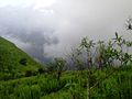
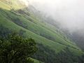
The Shola Forests and thick forest cover Kodachadri and the nearby hills and the place has a cool climate.[5] The forest of Kodachadri and nearby hills is tropical rain forest seen along with Western Ghats, a World Heritage Site.[10]
Iron ore
Kodachadri hill contains iron ore in its soil[11] and test digging was also done here during the 20th century and it was identified that the stones found here have magnetic properties.[12] However commercial mining in large scale did not take place at Kodachadri, though there are efforts to lease out the surrounding hills to mining companies to mine manganese and iron and local people have strongly opposed such a move in view of possible environmental damage.[13] In such anti-mining protests, local people under the leadership of Shri Raghaveshwara Bharathi of Ramachandrapura Mutt, Shivamogga district and environmentalist Ananth Hegde Ashisara demanded ban on all mining activities in Ambaragudda, which is near Kodachadri and other hills of the area.[13]
Places of interest
Sarvajna peetha

Sarvajna Peeth is a small temple like structure near the peak where
Ganesha Guha
Ganesha Guha is near the trekking path to Sarvajna peetha.
Iron Pillar
One iron pillar of about 40 feet length is planted erect in front of Moola Mookambika Temple near peak of Kodachadri and it is compared with massive similar historic iron pillars located at
Hidlumane Falls
Around 5 km from Kodachadri is Hidlumane Waterfalls and it can be reached by trekking on a bridle path.[7]

.
Arasinagundi falls
Another water falls in deep forest is Arasinagundi falls which 6 km from Kollur, at the bottom of Kodachadri near Dhalli village.[18]
Belakallu theertha
One more waterfalls called Belakallu theertha is located near Mudur, Jadkal (and 15 km from Kollur) and at the bottom of Kodachadri on southern side and involves easy trekking to reach.[18]
Nagara fort
Trekking in Kodachadri
Trekking to Kodachadri peak starts from
| Difficulty level | Moderate to Difficult |
| Approx Temperature | 30 degree |
| Washrooms | Toilets Only at Base Camp. Hotwater etc., as Per Availability. |
| Distance from Bangalore | 380 km (one way) |
| Total trekking distance | Approximately 20 – 22 km |
| Attraction | Beautiful landscape, Hidlumane Waterfall. |
Transportation
From Bangalore, one has to go to Shivamogga (285 km) and from there, one can take public transport to reach Nagodi village (Hosanagara Taluk). From Udupi, it is three hours journey to Nagodi village, from where trekking starts.[citation needed]
Kodachadri peak is connected with an all rough jeep road (partially metalled) on which only jeeps can travel. As this hilly road is not maintained properly, only expert local jeep drivers can take the jeep to the top. Jeeps are available for hire at Kollur and at
See also
- Mangalore
- Udupi
- Maravanthe
- Kollur
- St. Mary's Islands
- Mullayana Giri
- Baba Budan giri
- Brahmagiri
- Pushpagiri
Gallery
- Photos related to Kodachadri
-
 Kudachadri - scene1
 -
 Kudachadri - scene2
 -
 Sarvajna peeta at the peak of Kodachadri,western view
 -
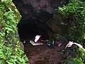 Kudachadri GaneshaGuha
 -
 On top of the Kodachadri mountains.
 -
 Trekking trail on top of the mountain
 -
 Kodachadri landscape
 -
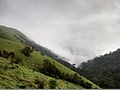 Hills seen from top of the mountain


References
- ^ "Trekking in Shimoga (Kodachadri) – A Trek Through the Rainforest". 22 December 2011.
- ^ Maps of, India. "Kodachadri, Karnataka". mapsofindia.com. Retrieved 12 August 2012.
- ^ Kaggere, Niranjan (2012). "Kodachadri now a Heritage site". Times of India- mobile e paper. Archived from the original on 27 December 2013. Retrieved 5 October 2012.
- ISBN 978-0-842-61004-9.
- ^ a b c d e f g h i C.V., Raghavendra Rao (11 April 2011). "Now, tourists can visit Kodachadri hills". The Times of India. Bangalore. Archived from the original on 3 November 2011. Retrieved 12 August 2012.
- ^ a b NML, Technical Journal (1995). NML Technical Journal Vol.37. New Delhi: National Metallurgical Laboratory (India). p. 133.
- ^ a b The, Hindu(news) (21 November 2011). "Sighting of wild elephant creates panic". Bangalore: The Hindu(newspaper). Retrieved 12 August 2012.
- ^ a b c Lewin Benthan, Bowring (1871). Eastern experiences. London: H.S.King. pp. 132, 133, 150.
- ISBN 9788172760236.
- ^ "Western Ghats". United Nations: United Nations Educational, Scientific and Cultural Organisation. Retrieved 13 August 2012.
- ^ Mysore, Govt. of (1964). Mysore Ports. Bangalore: Dept. of Publicity and Information.
- ISBN 9788120609778.
- ^ a b Special, Correspondent (17 August 2005). "Andolan seeks restoration of ban on mining at Ambargudda". The Hindu. Bangalore. Archived from the original on 23 April 2007. Retrieved 11 August 2012.
- ^ kumar, kondur. "Pics of Sharada or Saraswati devi shakthi peetha in POK". shakthipeethas.org. Retrieved 12 August 2012.
- ^ ISBN 978-8-173-05208-8.
- ^ a b "Articles13.HTM. | jun10 | currsci | Indian Academy of Sciences".
- ISBN 978-8-190-77700-1.
- ^ a b Ganesh, Prabhu; Ganesh Prabhu (12 July 2011). "Enchanting Kudlu Thirtha". Bangalore: The Hindu (newspaper). thehindu.com. Retrieved 12 August 2012.