
Kona District, Hawaii
This article needs additional citations for verification. (September 2019) |
19°41′58.56″N 155°59′24.00″W / 19.6996000°N 155.9900000°W


Left to right: the North and South Kona districts, within the Big Island.
Kona is a moku or district on the
Hōnaunau and Honalo
.
Description
In the
cognates with the same meaning in other Polynesian languages. In Tongan, the equivalent cognate would be tonga; for windward, the associated cognate would be tokelau
.
Kona is the home of the
Kailua-Kona
.
The Honokohau Settlement and Kaloko-Honokohau National Historical Park
are in Kona.
The volcanic slopes of Hualālai and Mauna Loa in the Kona district provide an ideal microclimate for growing coffee. Kona coffee is considered one of the premium specialty coffees of the world.[1][2]
Kona is the home of one of the main bases of the international Christian mission organization
YWAM, and the University of the Nations
, first founded there.
In popular culture
- The region served as the basis of the Beach Boys' song "Kona Coast" from their 1978 album M.I.U. Album.
- Asteroid M.P.C. 86717).[3]
Gallery
-
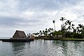
 Kealakekua Bay
 -
 Sunset in Kona
 -
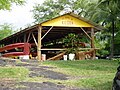 Canoe Hale at Honaunau Bay
 -
 Plymouth Rock, Kailua Kona, Big island, Hawaii
 -
 Kona Dog Beach, Big island, Hawaii


.jpg)
.jpg)
Further reading
- Juvik, Sonia P., 1998, Atlas of Hawaii, University of Hawaii Press, ISBN 978-0-8248-2125-8
- Kona Historical Society, 1997, A Guide to Old Kona, University of Hawaii Press, ISBN 978-0-8248-2010-7
References
- ^ a b c d "284891 Kona (2009 RT26)". Minor Planet Center. Retrieved 10 September 2019.
- ^ "CoffeeReview.com".
- ^ "MPC/MPO/MPS Archive". Minor Planet Center. Retrieved 10 September 2019.
External links
- Kona Historical Society web site
- Kona Kohala Chamber of Commerce web site
- North Kona shoreline access map at Hawaiʻi County web site
- South Kona shoreline access map at Hawaiʻi County web site
Islands, municipalities, and communities of Hawaii County, Hawaii, United States | ||
|---|---|---|
| CDPs |
|  |
| Unincorporated communities | ||
| Districts | ||
| ||