
Kousséri
This article needs additional citations for verification. (July 2010) |
Kousséri
قصور Mser, Fort Fureau | ||
|---|---|---|
Division Logone-et-Chari | | |
| Elevation | 271 m (889 ft) | |
| Population (2005) | ||
| • Total | 89,123 (Census) | |
| Climate | BSh | |
Kousséri (from
It forms a transborder agglomeration with the city of N'Djamena, capital of Chad, from which it is separated by the Logone River and the Chari River.[2]
History
Kousséri was part of the
In 1900 the village was occupied by soldiers of Rabij az-Zubayr (Rabih), a Sudanese warlord. On 3 March it was taken by the combined forces of two French expeditions, one under Major Lamy from Algeria and the other under Lt. Paul Joalland from Senegal and local forces opposed to Rabih. Rabih was not in Kousseri at the time but established himself in a fort on the right bank of the Chari. Lamy did not think he had sufficient forces to attack Rabih immediately, but waited until the beginning of April when he was joined by a third expedition that was coming up the Chari under Émile Gentil. When he arrived the combined forces crossed the Chari and attacked Rabih. The battle of Kousséri was a decisive battle which secured French rule over Chad.
Gallery
-
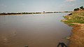 Chari river, from Kousséri
 -
 Chari river, in Central Africa, separates N'Djamena, in Chad, from Kousséri in Cameroon
 -
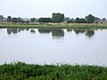
 Trade on Logone river

.jpg)

Notes
- ^ "KOUSSERI". Communes et Villes Unies de Cameroun. Retrieved 23 March 2020.
- ^ Cahiers de l'Afrique de l'Ouest Dynamiques de l'Urbanisation Africaine 2020: Africapolis, Une Nouvelle Géographie Urbaine. OECD. 20 fevereiro 2020
- OCLC 1193060
References
- Porch, Douglas (1984) The Conquest of the Sahara Knopf, New York, ISBN 0-394-53086-1

12°05′N 15°02′E / 12.083°N 15.033°E
This Cameroon location article is a stub. You can help Wikipedia by expanding it. |