
Kuala Besut
This article needs additional citations for verification. (January 2021) |
Kuala Besut
Kole Besuk ( Malaysian Standard Time ) |
|---|
Kuala Besut is a mukim in Besut District, Terengganu, Malaysia.
It is the departure point for boats to the Perhentian Islands. There are a variety of tour operators that tourist can choose for getting to Perhentian Islands. Small shops selling souvenirs of Perhentian Islands are also available around the town.
History
World War II
Gong Kedak
before proceeding to the capital of Terengganu.
Climate
Kuala Besut has a tropical rainforest climate (Af) with moderate rainfall from February to May and heavy to very heavy to very heavy rainfall in the remaining months.
| Climate data for Kuala Besut | |||||||||||||
|---|---|---|---|---|---|---|---|---|---|---|---|---|---|
| Month | Jan | Feb | Mar | Apr | May | Jun | Jul | Aug | Sep | Oct | Nov | Dec | Year |
| Mean daily maximum °C (°F) | 28.7 (83.7) |
29.5 (85.1) |
30.9 (87.6) |
32.0 (89.6) |
32.3 (90.1) |
32.0 (89.6) |
31.6 (88.9) |
31.3 (88.3) |
31.3 (88.3) |
30.6 (87.1) |
29.3 (84.7) |
28.6 (83.5) |
30.7 (87.2) |
| Daily mean °C (°F) | 25.6 (78.1) |
25.9 (78.6) |
26.8 (80.2) |
27.7 (81.9) |
28.0 (82.4) |
27.8 (82.0) |
27.4 (81.3) |
27.2 (81.0) |
27.2 (81.0) |
26.9 (80.4) |
26.2 (79.2) |
25.8 (78.4) |
26.9 (80.4) |
| Mean daily minimum °C (°F) | 22.5 (72.5) |
22.4 (72.3) |
22.8 (73.0) |
23.5 (74.3) |
23.8 (74.8) |
23.6 (74.5) |
23.2 (73.8) |
23.2 (73.8) |
23.1 (73.6) |
23.2 (73.8) |
23.2 (73.8) |
23.0 (73.4) |
23.1 (73.6) |
| Average rainfall mm (inches) | 252 (9.9) |
116 (4.6) |
125 (4.9) |
80 (3.1) |
118 (4.6) |
137 (5.4) |
119 (4.7) |
190 (7.5) |
224 (8.8) |
288 (11.3) |
535 (21.1) |
621 (24.4) |
2,805 (110.3) |
| Source: Climate-Data.org[1] | |||||||||||||
Gallery
-
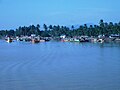
 Kuala Besut Harbour and Jetty
 -
 Kuala Besut river seen from the main bridge


References
- ^ "Climate: Kuala Besut". Climate-Data.org. Retrieved 28 October 2020.
External links
Wikimedia Commons has media related to Kuala Besut.
Wikivoyage has a travel guide for Kuala Besut.
State of Terengganu | |||||||||||
|---|---|---|---|---|---|---|---|---|---|---|---|
Capital: Kuala Terengganu | |||||||||||
| Topics | |||||||||||
| Society | |||||||||||
| Administrative divisions |
| ||||||||||
5°50′N 102°34′E / 5.833°N 102.567°E
This article about a location in the Sultanate of Terengganu is a stub. You can help Wikipedia by expanding it. |