
Kumba
This article needs additional citations for verification. (October 2021) |
Kumba | ||
|---|---|---|
Division Meme (department) | | |
| District | Central Kumba | |
| Elevation | 240 m (790 ft) | |
| Population (2019) | ||
| • Total | 144,413 [1] | |


Kumba is a metropolitan city in the Meme department, Southwest Region, Western Cameroon, commonly referred to as "K-town" colloquially. Kumba is the largest and most developed city in the Meme Department and is increasingly drawing in residents from the local villages such as Mbonge. It is also the largest urban area in the South-West. Kumba has an estimated population of about 400,000 with three quarters of this population being young due to advancement in medicine and lowering infant mortality. The N8 and N16 highways meet at Kumba.
Etymology
The name 'Kumba' originates from the Bafo word 'Bakumbè', meaning an umbrella tree
History
According to local mythology, Kumba was founded by the hunter Midiki Bokeng, In his honour a monument has been put up around the Town Green. Kumba was originally a Bafo tribal capital formed after the Mediki wars. Mediki was a Bafo native sent by the Bafo chief Nguti to fight other tribes around the settlement which he did successfully. Mediki fought together with Eseme Modu and capture territories as far as Ekombe. The settlement of Kumba was capital of former Rio Del Rey Division in
On the 24th October 2020, a mass shooting took place at a school, 7 died and 13 were injured.
Economy
Kumba is a trade centre for
Geography
Kumba is the largest town in the Meme Department and
-
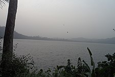 Crater Lake, Kumba
 -
 Forest Reserve, Lake Barombi
 -
 Bakundu Forest Reserve, Lake Barombi
 -
 Lake Barombi
 -
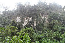
 Pyroclastic deposit, Kumba


Administration
Kumba is the capital of the Meme department of the Southwest Region. It has three sub-divisional councils: Kumba 1 (Kumba Town-Kake, a part of Buea Road), Kumba 2 (Kosala, Hausa-quarters and Fiango) and Kumba 3 (Three Corners, Mambanda and a part of Buea Road), each has a local mayor. The town is also run by a government appointed Senior Divisional Officer (SDO) and a government delegate.
Transport
Kumba is the terminus of a branch railway of the western system of Camrail. Kumba has three major motor parks: one situated at Buea road in Barombi Kang, the second at Fiango (Three Corners), and the third on Mbonge road (Mile One).
-
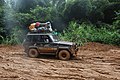
 Transport in Kumba in the rainy season
 -
-

-


People and Culture
Languages
The majority of the Kumba people speak
The ethnic groups of Kumba are the
See also
References
- ^ "Population of Cities in Cameroon (2021)". Archived from the original on 2021-05-23.
| Fako |
| |
|---|---|---|
| Koupé-Manengouba | ||
| Lebialem | ||
| Manyu |
| |
| Meme | ||
| Ndian | ||
4°38′N 9°27′E / 4.633°N 9.450°E
| International | |
|---|---|
| National | |