
Kuril Islands
This article needs additional citations for verification. (April 2023) |
| Disputed islands | |
|---|---|
 A coastline along one of the Kuril Islands | |
 Location of the Kuril Islands in the Western Pacific between Japan and the Kamchatka Peninsula of Russia | |
| Geography | |
| Location | Pacific Ocean |
| Coordinates | 47°00′N 152°06′E / 47.0°N 152.1°E |
| Total islands | 56 |
| Area | 10,503.2 km2 (4,055.3 sq mi) |
| Length | 1,150 km (715 mi) |
| Highest elevation | 2,339 m (7674 ft) |
| Highest point | Alaid |
| Administration | |
| Federal subject | Sakhalin Oblast |
| Districts | Severo-Kurilsky, Kurilsky, Yuzhno-Kurilsky |
| Claimed by | |
| Prefecture | Hokkaido |
| Subprefecture | Nemuro |
| Demographics | |
| Population | 21,501 (2021) |
| Ethnic groups | majority Russians |

The Kuril Islands or Kurile Islands (/ˈk(j)ʊərɪl, kjʊˈriːl/; Russian: Кури́льские острова́, tr. Kuril'skiye ostrova, IPA: [kʊˈrʲilʲskʲɪjə ɐstrɐˈva]; Japanese: Kuriru rettō (クリル列島, "Kuril Islands") or Chishima rettō (千島列島, "Thousand Islands")) are a volcanic archipelago administered as part of Sakhalin Oblast in the Russian Far East.[1] The islands stretch approximately 1,300 km (810 mi) northeast from Hokkaido in Japan to Kamchatka Peninsula in Russia, separating the Sea of Okhotsk from the north Pacific Ocean. There are 56 islands and many minor islets. The Kuril Islands consist of the Greater Kuril Chain and, at the southwest end, the parallel Lesser Kuril Chain.[2] They cover an area of around 10,503.2 square kilometres (4,055.3 sq mi),[3] with a population of roughly 20,000.[4]
The islands have been under Russian administration since their
Etymology
The name Kuril originates from the
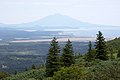
Geography and climate

The Kuril Islands form part of the ring of
The climate on the islands is generally severe, with long, cold, stormy winters and short and notoriously foggy summers. The average annual precipitation is 40 to 50 inches (1,020 to 1,270 mm), a large portion of which falls as snow. The
The chain ranges from temperate to sub-Arctic climate types, and the vegetative cover consequently ranges from
Landscape types and habitats on the islands include many kinds of beach and rocky shores, cliffs, wide rivers and fast gravelly streams, forests, grasslands,
.jpg)
The northernmost,
Ecology
Marine
Owing to their location along the Pacific shelf edge and the confluence of Okhotsk Sea gyre and the southward Oyashio Current, the Kuril islands are surrounded by waters that are among the most productive in the North Pacific, supporting a wide range and high abundance of marine life.
Fish: Further offshore, walleye pollock, Pacific cod, several species of flatfish are of the greatest commercial importance. During the 1980s, migratory Japanese sardine was one of the most abundant fish in the summer.
Terrestrial
The composition of terrestrial species on the Kuril islands is dominated by Asian mainland taxa via migration from Hokkaido and Sakhalin Islands and by Kamchatkan taxa from the North. While highly diverse, there is a relatively low level of endemism on a species level.
The
Because of the generally smaller size and isolation of the central islands, few major terrestrial mammals have colonized these, though
Among terrestrial birds, ravens, peregrine falcons, some wrens and wagtails are common.
History
Early history

The
American whaleships caught right whales off the islands between 1847 and 1892.[13] Three of the ships were wrecked on the islands: two on Urup in 1855[14][15] and one on Makanrushi in 1856.[16] In September 1892, north of Kunashir Island, a Russian schooner seized the bark Cape Horn Pigeon, of New Bedford and escorted it to Vladivostok, where it was detained for nearly two weeks.[17]
Japanese administration
At the very end of the 19th century, the Japanese administration started the forced assimilation of the native Ainu people.[18][19] Also at this time the Ainu were granted automatic Japanese citizenship, effectively denying them the status of an indigenous group. Many Japanese moved onto former Ainu lands, including the Kuril islands. The Ainu were required to adopt Japanese names, and ordered to cease religious practices such as animal sacrifice and the custom of tattooing.[19] Although not compulsory, education was conducted in Japanese. Prior to Japanese colonization[20] (in 1868) about 100 Ainu reportedly lived on the Kuril islands.[21]
World War II
- In 1941 Admiral Hitokappu Bay, IturupIsland, South Kurils. The territory was chosen for its sparse population, lack of foreigners, and constant fog-coverage. The Admiral ordered the move to Hawaii on the morning of 26 November.
- On 10 July 1943 the first bombardment against the Japanese bases in 77th Bombardment Squadrontook off, led by Capt James L. Hudelson. This mission principally struck Paramushir.
- Another mission was flown during 11 September 1943 when the Kamchatka.
- The Eleventh Air Force implemented other bombing missions against the northern Kurils, including a strike by six P-38s from the 54th Fighter Squadronon 5 February 1944.
- Japanese sources[Matsuwamilitary installations were subject to American air-strikes between 1943 and 1944.
- The Americans' strategic feint called "Hokkaidō area in anticipation that the Americans might invade from Alaska.

- American planners had briefly contemplated an invasion of northern Boeing B-29 Superfortresses, on Amchitka and Shemya bases, but rejected the idea. The U.S. military maintained interest in these plans when they ordered the expansion of bases in the western Aleutians, and major construction began on Shemya. In 1945, plans for a possible invasion of Japan via the northern route were shelved[by whom?].
- Between 18 August and 31 August 1945 Soviet forces invaded the North and South Kurils.
- The Soviets expelled the entire Japanese civilian population of roughly 17,000 by 1946.
- Between 24 August and 4 September 1945 the Eleventh Air Force of the United States Army Air Forces sent two B-24s on reconnaissance missions over the North Kuril Islands with the intention of taking photos of the Soviet occupation in the area. Soviet fighters intercepted and forced them away.[citation needed]
In February 1945 the
Russian administration
The Kuril Islands are split into three administrative districts (raions), each a part of Sakhalin Oblast:
- Severo-Kurilsky District (Severo-Kurilsk)
- Kurilsky District (Kurilsk)
- Yuzhno-Kurilsky District (Yuzhno-Kurilsk)
Japan maintains a claim to the three islands of
On 8 February 2017 the Russian government gave names to five previously unnamed Kuril islands in Sakhalin Oblast: Derevyanko Island (after Kuzma Derevyanko, 43°22′8″N 146°1′3″E / 43.36889°N 146.01750°E), Gnechko Island (after Alexey Gnechko, 43°48′5″N 146°52′1″E / 43.80139°N 146.86694°E), Gromyko Island (after Andrei Gromyko, 46°14′1″N 150°36′1″E / 46.23361°N 150.60028°E), Farkhutdinov Island (after Igor Farkhutdinov, 43°48′5″N 146°53′2″E / 43.80139°N 146.88389°E) and Shchetinina Island (after Anna Shchetinina, 46°13′7″N 150°34′6″E / 46.21861°N 150.56833°E).[24]
Demographics


As of 2013[update], 19,400 people inhabited the Kuril Islands, of which 16,700 lived on the four disputed southern islands and 2,600 lived on
Economy
In 2014, construction workers built a pier and a breakwater in Kitovy Bay, central Iturup, where barges are a major means of transport, sailing between the cove and ships anchored offshore. A new road has been carved through the woods near Kurilsk, the island's biggest village, going to the site of Yuzhno-Kurilsk Mendeleyevo Airport.[26]
Gidrostroy, the Kurils' biggest business group with interests in fishing, construction and real estate, built its second fish processing factory on Iturup island in 2006, introducing a state-of-the-art conveyor system.
To deal with a rise in the demand of electricity, the local government is also upgrading a state-run geothermal power plant at Mount Baransky, an active volcano, where steam and hot water can be found.[27]
In 2022, a special economic zone was established on the Kuril islands with special tax regimes, exemption from corporate income tax, VAT with reduced customs duties for 20 years.
Military
The main Russian force stationed on the islands is the 18th Machine Gun Artillery Division, which has its headquarters in Goryachiye Klyuchi on the Iturup Island. There are also Border Guard Service troops stationed on the islands. In February 2011, Russian President Dmitry Medvedev called for substantial reinforcements of the Kuril Islands defences. Subsequently, in 2015, additional anti-aircraft missile systems Tor and Buk, coastal defence missile system Bastion, Kamov Ka-52 combat helicopters and one Varshavyanka project submarine came on defence of Kuril Islands.[citation needed] During the 2022 Russian Invasion of Ukraine it was reported that parts of the 18th Machine Gun Artillery Division were redeployed to Eastern Ukraine.[31]
List of main islands
While in Russian sources[citation needed] the islands are mentioned for the first time in 1646, the earliest detailed information about them was provided by the explorer Vladimir Atlasov in 1697. In the 18th and early 19th centuries, the Kuril Islands were explored by Danila Antsiferov, I. Kozyrevsky, Ivan Yevreinov, Fyodor Luzhin, Martin Spanberg, Adam Johann von Krusenstern, Vasily Golovnin, and Henry James Snow.
-
 Yuzhno-Kurilsk, Kunashir
 -
 Severo-Kurilsk, Paramushir
 -
 Atlasov
 -
 A view of the volcano Bogdan Khmelnitsky on Iturup Island
 -
 Mendeleyeva in the southern part of Kunashir
 -
 Yuzhno-Kurilsky District
 -
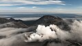 Ebeko volcano, Paramushir
 -
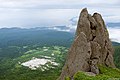
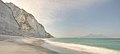 White Rocks, Iturup


The following table lists information on the main islands from north to south:
| Island | Russian: Name | Japanese: Name | Alternative names |
Island Group | Administrative centre / Landing point |
Other settlements | Area | Pop. |
|---|---|---|---|---|---|---|---|---|
| Severo-Kurilsky District | North Kurils | North Kurils (Kita-chishima / 北千島) | Severo-Kurilsk | Shelikovo, Podgorny , Baikovo
|
3,504 km2 (1,353 sq mi) |
2,560 | ||
| Shumshu | Шумшу | 占守島 | Shumushu | North Kurils | Baikovo | 388 km2 (150 sq mi) |
20 | |
| Atlasov | Атласова | 阿頼度島 | Oyakoba, Araido | North Kurils | Alaidskaya Bay | 150 km2 (58 sq mi) |
0 | |
| Paramushir | Парамушир | 幌筵島 | Paramushiru, Horomushiro | North Kurils | Severo-Kurilsk | Shelikovo, Podgorny
|
2,053 km2 (793 sq mi) |
2,540 |
| Antsiferov | Анциферова | 志林規島 | Shirinki | North Kurils | Antsiferov beach | Cape Terkut | 7 km2 (2.7 sq mi) |
0 |
| Makanrushi | Маканруши | 磨勘留島 | Makanru | North Kurils | Zakat | 50 km2 (19 sq mi) |
0 | |
| Avos' | Авось | 帆掛岩 | Hokake, Hainoko | North Kurils | 0.1 km2 (0.039 sq mi) |
0 | ||
| Onekotan | Онекотан | 温禰古丹島 | Onwakotan | North Kurils | Mussel | Kuroisi, Nemo, Shestakov | 425 km2 (164 sq mi) |
0 |
| Kharimkotan | Харимкотан | 春牟古丹島 春牟古丹島 |
Harimukotan, Harumukotan | North Kurils | Sunazhma | Severgin Bay | 70 km2 (27 sq mi) |
0 |
| Ekarma | Экарма | 越渇磨島 | Ekaruma | North Kurils | Kruglyy | 30 km2 (12 sq mi) |
0 | |
| Chirinkotan | Чиринкотан | 知林古丹島 | North Kurils | Cape Ptichy | 6 km2 (2.3 sq mi) |
0 | ||
| Shiashkotan | Шиашкотан | 捨子古丹島 | Shasukotan | North Kurils | Makarovka | 122 km2 (47 sq mi) |
0 | |
| Lowuschki-Felsen | Ловушки | 牟知列岩 | Mushiru | North Kurils | 1.5 km2 (0.58 sq mi) |
0 | ||
| Raikoke | Райкоке | 雷公計島 | North Kurils | Raikoke | 4.6 km2 (1.8 sq mi) |
0 | ||
| Matua | Матуа | 松輪島 | Matsuwa | North Kurils | Sarychevo | 52 km2 (20 sq mi) |
0 | |
| Rasshua | Расшуа | 羅処和島 | Rashowa, Rasutsua | North Kurils | Arches Point | 67 km2 (26 sq mi) |
0 | |
| Srednego | Среднего | 摺手岩 | Suride | North Kurils | Unknown | 0 | ||
| Ushishir | Ушишир | 宇志知島 | Ushishiru | North Kurils | Kraternya | Ryponkicha | 5 km2 (1.9 sq mi) |
0 |
| Ketoy | Кетой | 計吐夷島 | Ketoi | North Kurils | Storozheva | 73 km2 (28 sq mi) |
0 | |
| Kurilsky District | Middle Kurils (Naka-chishima / 中千島) | split between both Japanese groups | Kurilsk | Reidovo, Kitovyi, Rybaki, Goryachiye Klyuchi, Kasatka, Burevestnik, Shumi-Gorodok, Gornyy | 5,138 km2 (1,984 sq mi) |
6,606 | ||
| Simushir | Симушир | 新知島 | Shimushiru, Shinshiru | North Kurils | Kraternyy | Srednaya bay | 360 km2 (140 sq mi) |
0 |
| Broutona | Броутона | 武魯頓島 | Buroton, Makanruru | North Kurils | Nedostupnyy | 7 km2 (2.7 sq mi) |
0 | |
Chirpoy
|
Чирпой | 知理保以島 | Chirihoi, Chierupoi | North Kurils | Peschanaya Bay | 21 km2 (8.1 sq mi) |
0 | |
Brat Chirpoyev
|
Брат Чирпоев | 知理保以南島 | Chirihoinan | North Kurils | Garovnikova | Semenova | 16 km2 (6.2 sq mi) |
0 |
| Urup | Уруп | 得撫島 | Uruppu | North Kurils | Mys Kastrikum | Mys Van-der-Lind | 1,450 km2 (560 sq mi) |
0 |
| Other | North Kurils | 4.4 km2 (1.7 sq mi) |
0 | |||||
| Iturup | Итуруп | 択捉島 | Etorofu, Ietorupu | South Kurils (Minami-chishima / 南千島) | Kurilsk | Reidovo, Kitovyi, Rybaki, Goryachiye Klyuchi, Kasatka, Burevestnik, Shumi-Gorodok, Gornyy | 3,280 km2 (1,270 sq mi) |
6,602 |
| Yuzhno-Kurilsky District | South Kurils | South Kurils | Yuzhno-Kurilsk | Malokurilskoye, Rudnaya, Lagunnoye, Otrada, Goryachiy Plyazh, Aliger, Mendeleyevo, Dubovoye, Polino, Golovnino | 1,860.8 km2 (718.5 sq mi) |
10,268 | ||
| Kunashir | Кунашир | 国後島 | Kunashiri | South Kurils | Yuzhno-Kurilsk | Rudnaya, Lagunnoye, Otrada, Goryachiy Plyazh, Aliger, Mendeleyevo, Dubovoye, Polino, Golovnino | 1,499 km2 (579 sq mi) |
7,800 |
| Shikotan Island | Шикотан | 色丹島 | South Kurils | Malokurilskoye | Dumnova, Otradnaya, Voloshina , Kray Sveta
|
255 km2 (98 sq mi) |
2,440 | |
| Other | South Kurils | Ayvazovskovo | 9.1 km2 (3.5 sq mi) |
0 | ||||
Khabomai
|
Хабомаи | 歯舞群島 | Habomai | South Kurils | Zorkiy | Zelyony, Polonskogo | 97.7 km2 (37.7 sq mi) |
28 |
| Polonskogo | Полонского | 多楽島 | Taraku | South Kurils | Moriakov Bay station | 11.57 km2 (4.47 sq mi) |
2 | |
| Oskolki | Осколки | 海馬島 | Todo, Kaiba | South Kurils | Unknown | 0 | ||
| Zelyony | Зелёный | 志発島 | Shibotsu | South Kurils | Glushnevskyi station | 58.72 km2 (22.67 sq mi) |
3 | |
| Kharkar | Харкар | 春苅島 | Harukaru, Dyomina | South Kurils | Haruka | 0.8 km2 (0.31 sq mi) |
0 | |
| Yuri | Юрий | 勇留島 | Yuri | South Kurils | Kalernaya | 10.32 km2 (3.98 sq mi) |
0 | |
| Anuchina | Анучина | 秋勇留島 | Akiyuri | South Kurils | Bolshoye Bay | 2.35 km2 (0.91 sq mi) |
0 | |
| Tanfil'yev | Танфильев | 水晶島 | Suishō | South Kurils | Zorkiy | Tanfilyevka Bay, Bolotnoye | 12.92 km2 (4.99 sq mi) |
23 |
| Storozhevoy | Сторожевой | 萌茂尻島 | Moemoshiri | South Kurils | 0.07 km2 (0.027 sq mi) |
0 | ||
| Rifovyy | Рифовый | オドケ島 | Odoke | South Kurils | Unknown | 0 | ||
| Signal'nyy | Сигнальный | 貝殻島 | Kaigara | South Kurils | 0.02 km2 (0.0077 sq mi) |
0 | ||
| Other | South Kurils | Opasnaya, Udivitelnaya | 1 km2 (0.39 sq mi) |
0 | ||||
| Total: | 10,503.2 km2 (4,055.3 sq mi) |
19,434 | ||||||
See also
- 2006 Kuril Islands earthquake
- 2007 Kuril Islands earthquake
- Chishima Province
- Evacuation of Karafuto and Kuriles
- Invasion of the Kuril Islands
- Karafuto Fortress
- Karafuto Prefecture
- Organization of Hokkai (North) Army
- Organization of Kita and Minami Fortresses
- Political divisions of Karafuto Prefecture
- Zemlyak
References
- ^ "Kuril Islands". Britannica.com. 14 April 2023. Archived from the original on 17 May 2020. Retrieved 3 August 2017.
- ^ GSE Archived 2013-04-24 at the Wayback Machine
- ^ "SAKHALIN.RU: Sakhalin and the Kuriles. Geography". Archived from the original on 2011-01-14. Retrieved 2011-02-01.
- ^ "Kuril Islands: factfile". The Daily Telegraph. London. November 1, 2010. Archived from the original on November 28, 2020. Retrieved April 3, 2018.
- ^ a b Koike, Yuriko (31 March 2014). "Japan's Russian Dilemma". Archived from the original on 31 August 2017. Retrieved 5 August 2014.
- ^ "Глава 26. Коренное население: айны". Archived from the original on 2022-02-18. Retrieved 2021-09-01.
- ^ "Central Kuril Island Tsunami in Crescent City, California". University of Southern California Tsunami Research Center. 16 November 2006. Archived from the original on 4 December 2006. Retrieved 1 September 2023.
- S2CID 20154991.
- ^ "Kuril islands (between Urup and Paramushir)". BirdLife Data Zone. BirdLife International. 2021. Archived from the original on 5 December 2020. Retrieved 7 February 2021.
- ISBN 978-0-19-821563-9. Archivedfrom the original on 2023-07-07. Retrieved 2021-01-27.
- ISBN 9780198215639. Archivedfrom the original on 7 July 2023. Retrieved 27 January 2021.
According to subsequent elaborations, a document in the Central State Archives [...] indicated that a merchant adventurer by the name of Fedot Alekseev Popov had reached the Kurils in 1649 after completing an odyssey from the Arctic [...] popular Soviet publications [...] have enshrined Popov as the discoverer of the Kurils.
- ISBN 9785884531222. Archivedfrom the original on 7 July 2023. Retrieved 27 January 2021.
Russians first set foot on the Kuril islands in August 1711 , when a detachment of Kamchatka Cossacks under the leadership of Daniil Antsiferov and Ivan Kozyrevsky landed on Shumshu, the northernmost of the Greater Kurils.
- ^ Eliza Adams, of Fairhaven, May 29 – Jun 13, June 24-Aug. 1, 1847, Old Dartmouth Historical Society (ODHS); Splendid, of Edgartown, Aug. 12-Sep. 6, 1848, Nicholson Whaling Collection (NWC); Shepherdess, of Mystic, May 8–30, 1849, NWC; Hudson, of Fairhaven, Oct. 6, 1857, Kendall Whaling Museum (KWM); Sea Breeze, of New Bedford, Oct. 5–18, 1868, ODHS; Cape Horn Pigeon, of New Bedford, Aug. 23-Sep. 10, 1892, KWM.
- ^ Lexington, of Nantucket, May 31, 1855, Nantucket Historical Association.
- ISBN 1-55521-537-8.
- ^ The Friend (Vol. V, No. 12, Dec. 11, 1856, p. 93, Honolulu).
- ^ Cape Horn Pigeon, of New Bedford, Sep. 10, Sep. 19-Oct. 1, 1892, KWM.
- ISBN 978-4-88322-597-2.
- ^ ISBN 978-0-684-80617-4.
- ISBN 978-0-41513-228-2.
- ISBN 978-9-00410-735-9.
- ISBN 9781935149927. Archivedfrom the original on 7 July 2023. Retrieved 27 January 2021.
Operation WEDLOCK in 1944 created a notional force in the northern Pacific that appeared ready to invade the Kuril Islands. This pinned down Japanese troops and equipment in an area the Americans had no intention of attacking.
- ^ "Foreign Relations of the United States: Diplomatic Papers, Conferences at Malta and Yalta, 1945 - Office of the Historian". history.state.gov. Archived from the original on 2019-04-04. Retrieved 2019-04-04.
- ^ "Распоряжение Правительства Российской Федерации от 08.02.2017 № 223-р" [Decree of the Government of the Russian Federation No. 223-r dated February 8, 2017] (in Russian). Publication.pravo.gov.ru. 8 February 2017. Archived from the original on 11 February 2017. Retrieved 11 February 2017.
- ^ "It was hoped that the proceeds from the ongoing projects would help to alleviate the high level of poverty in the region". Eastern Europe, Russia and Central Asia, s.v. Sakhalin Oblast" (Europa Publications) 2003.
- ^ "Profile on Yuzhno-Kurilsk Mendeleyevo Airport". Archived from the original on August 21, 2014. Retrieved May 24, 2014.
- ^ "Islands disputed with Japan feel Russia's boom". Archived from the original on 2007-10-29.
- ^ "Федеральный закон от 18.03.2023 № 84-ФЗ ∙ Официальное опубликование правовых актов". publication.pravo.gov.ru. Retrieved 7 December 2023.
- ^ "Law on preferential regime in Kuril Islands to be effective in 2 months — Deputy PM". tass.com. Feb 2, 2022. Retrieved 7 December 2023.
- ^ "President Putin's Speech at the 2023 Far Eastern Economic Forum: Analysis". Russia Briefing News. 13 September 2023. Retrieved 7 December 2023.
- ^ Sebastien Roblin. "Russia Sends Pacific Island 'Machine Gun Artillery Division' To Ukraine". Forbes.com. Archived from the original on 2022-07-21. Retrieved 2022-08-04.
Further reading
- Gorshkov, G. S. Volcanism and the Upper Mantle Investigations in the Kurile Island Arc. Monographs in geoscience. New York: Plenum Press, 1970. ISBN 0-306-30407-4
- Krasheninnikov, Stepan Petrovich, and James Greive. The History of Kamtschatka and the Kurilski Islands, with the Countries Adjacent. Chicago: Quadrangle Books, 1963.
- Rees, David. The Soviet Seizure of the Kuriles. New York: Praeger, 1985. ISBN 0-03-002552-4
- Takahashi, Hideki, and Masahiro Ōhara. Biodiversity and Biogeography of the Kuril Islands and Sakhalin. Bulletin of the Hokkaido University Museum, no. 2-. Sapporo, Japan: Hokkaido University Museum, 2004.
- Hasegawa, Tsuyoshi. Racing the Enemy: Stalin, Truman, and the Surrender of Japan. 2006. ISBN 978-0-674-02241-6.
- Alan Catharine and Denis Cleary. Unwelcome Company. A fiction thriller novel set in 1984 Tokyo and the Kuriles featuring a light aircraft crash and escape from Russian-held territory. On Kindle.
External links
- Southern Kuriles / Northern Territories: A Stumbling-block in Russia-Japan Relationship, history and analysis by Andrew Andersen, Department of Political Science, University of Victoria, May 2001
- http://depts.washington.edu/ikip/index.shtml (Kuril Island Biocomplexity Project)
- Kuril Islands at Ocean Dots.com at the Wayback Machine (archived December 23, 2010) (includes space imagery)
- Kuril Islands at Natural Heritage Protection Fund
- The International Kuril Island Project
- http://www.mofa.go.jp/region/europe/russia/territory/index.html
- Chishima: Frontiers of San Francisco Treaty in Hokkaido Short film on the disputed islands from a Japanese perspective
- USGS Map showing location of Magnitude 8.3 Earthquake 46.616°N, 153.224°E Kuril Islands region, November 15, 2006 11:14:16 UTC
- Pictures of Cats – Kurilian Bobtail
- Pictures of Kuril Islands
- Kuril Islands at Encyclopædia Britannica
| International | |
|---|---|
| National | |