
Kutch district
Kutch | ||
|---|---|---|
Vidhan Sabha constituencies 6 | | |
| Area | ||
| • Total | 45,674 km2 (17,635 sq mi) | |
| Population (2011) | ||
| • Total | 2,092,371 | |
| • Density | 46/km2 (120/sq mi) | |
| Demographics | ||
| • Literacy | 70.59 | |
| • Sex ratio | 908 | |
| • Language | ||
| Time zone | UTC+05:30 (Indian Standard Time) | |
| Vehicle registration | GJ-12 | |
| Major highways | 1 | |
| Website | kachchh | |
| Official name | Dholavira: A Harappan City | |
| Type | Cultural | |
| Criteria | Cultural: (iii)(iv) | |
| Designated | 2021 (44th session) | |
| Reference no. | 1645 | |
| Region | Southern Asia | |
Kutch district, officially spelled Kachchh, is a
Kutch literally means something which intermittently becomes wet and dry; a large part of this district is known as Rann of Kutch which is shallow wetland which submerges in water during the rainy season and becomes dry during other seasons. The same word is also used in Sanskrit origin for a tortoise. The Rann is known for its marshy salt flats which become snow white after the shallow water dries up each season before the monsoon rains.
The district is also known for ecologically important Banni grasslands with their seasonal marshy wetlands which form the outer belt of the Rann of Kutch.
Kutch is surrounded by the
History

The history of Kutch can be traced back to prehistoric times. There are several sites related to the
Hieun Tsang refers to Kutch as Kiecha in his writings. In the seventh century, Kutch was being ruled by Charans, Kathis, and Chavdas.[5][6] The Chavdas ruled the eastern and central parts by the seventh century, but Kutch came under the rule of the Chaulukya dynasty by the tenth century. After the fall of Chaulukya, the Vaghelas ruled the state. By the thirteenth century, the Vaghelas controlled the whole of Kutch and adopted a new dynastic identity, Jadeja.
For three centuries, Kutch was divided and ruled by three different branches of the
Upon the
-
![Dholavira, one of the largest cities of the Indus Valley Civilisation, with stepwell steps to reach the water level in artificially constructed reservoirs.[7]](//upload.wikimedia.org/wikipedia/commons/thumb/8/89/DHOLAVIRA_SITE_%2824%29.jpg/270px-DHOLAVIRA_SITE_%2824%29.jpg)
-
 TenDholavira Signboard.
 -
 Coat of Arms ofPrincely State of Cutchdating back to 1893 CE.
 -
 Flag of the Princely State of Cutch
![Dholavira, one of the largest cities of the Indus Valley Civilisation, with stepwell steps to reach the water level in artificially constructed reservoirs.[7]](/File:DHOLAVIRA_SITE_(24).jpg)


Topography
Kutch District, at 45,674 square kilometres (17,635 sq mi), is the largest
. Kutch has 969 villages. Kala Dungar (Black Hill) is the highest point in Kutch at 458 metres (1,503 ft).
Kutch is virtually an island, as it is surrounded by the
Rivers and dams
There are ninety-seven small rivers in Kutch District, most of which flow into the Arabian Sea, but some of which feed the Rann of Kutch.[9] Twenty major dams,[10] and numerous smaller dams, capture the rainy season runoff.[11] While most of these dams do not affect the Ranns, as they are on rivers that feed directly into the Arabian Sea, storage of rainy season water upstream from Kutch and its use in irrigation has resulted in less fresh water coming into the Ranns of Kutch during the rainy season. This is true of the Great Rann, but particularly true of the Little Rann which is fed by the Luni, Rupen, the Bambhan, the Malwan, the Kankawati, and the Saraswati rivers. However sea water from the Arabian Sea still continues to be driven into the Great Rann by storm tides aided by high winds.[12] Water remains a serious issue in Kutch.[13] Kutch's thirst for water is satisfied by Narmada river flowing from Sardar Sarovar dam.


| Dam | Reservoir | River | depth in meters when full |
near |
|---|---|---|---|---|
| Bhukhi Dam | Bhukhi | 72.78 | ||
| Berachiya Dam | Nyara | 70.40 | ||
| Chang Dam | 18.00 | |||
| Don Dam | Kharod | 47.75 | ||
| Fatehgadh Dam | Malan | 22.70 | ||
| Gajansar Dam | Gajansar | Panjora | 31.08 | |
| Gajod Dam | Nagmati | 90.82 | ||
| Godhatad Dam | Mitiariwali | 23.00 | ||
| Goyala Dam | Goyala | Sugandhi | 8.00 | |
| Jangadia Dam | Janghadia | Khari | 38.60 | |
| Kaila Dam | Kaila | 79.25 | ||
| Kalaghogha Dam | Phot | 37.00 | ||
| Kankawati Dam | Kankawati | 131.67 | ||
| Kaswati Dam | Kaswati | 51.20 | ||
| Mathal Dam | Dhadodh | 82.78 | ||
| Mitti Dam | Mitti | Mitti | 18.50 | |
| Nara Dam | Nara | 27.43 | ||
| Nirona Dam | Bhurud | 43.58 | ||
| Rudramata Dam | Rudramati (Khari) | 66.44 | ||
| Sanandro Dam | Kali | 59.74 | ||
| Suvi Dam | Suvi | 42.67 | Lilpar | |
| Tappar (W.S) Dam | Sakara | 40.85 | ||
| Vijay sagar Dam | 33.00 |
Divisions
Kutch is divided into four zones:
- Wagad (including Rapar, Bhachau taluka and Little Rann)
- Kanthi (coastal area, derived from Gujarati:કાંઠો), comprising Mundra and half of Mandvi taluka.
- Banni (with Pascham; includes Bhuj, Nakhatrana and surrounding areas)
- Makpat (includes part of Nakhatrana and Lakhapat taluka).[14]

Under the Kutch princely state, Kutch was divided into Bani, Abdasa, Anjar, Banni, Bhuvad Chovisi, Garado, Halar Chovisi, Kand, Kantho, Khadir, Modaso, Pranthal, Prawar, and Vagad.
Kutch District is further divided into six subdistricts, each comprising one or two
- Bhuj (Bhuj taluka)
- Anjar (Anjar and Gandhidham)
- Nakhatrana (Nakhatrana and Lakhpat)
- Naliya (Abdasa-Naliya)[15]
Wildlife sanctuaries and reserves
From the city Bhuj various ecologically rich and wildlife conservation areas of the Kutch district can be visited such as Indian Wild Ass Sanctuary, Kutch Desert Wildlife Sanctuary, Narayan Sarovar Sanctuary, Kutch Bustard Sanctuary, Banni Grasslands Reserve and Chari-Dhand Wetland Conservation Reserve.
Demographics
| Year | Pop. | ±% p.a. |
|---|---|---|
| 1901 | 488,022 | — |
| 1911 | 513,429 | +0.51% |
| 1921 | 484,547 | −0.58% |
| 1931 | 520,496 | +0.72% |
| 1941 | 507,880 | −0.25% |
| 1951 | 567,606 | +1.12% |
| 1961 | 696,440 | +2.07% |
| 1971 | 849,769 | +2.01% |
| 1981 | 1,050,161 | +2.14% |
| 1991 | 1,262,507 | +1.86% |
| 2001 | 1,583,225 | +2.29% |
| 2011 | 2,092,371 | +2.83% |
| source:[16] | ||
According to the
Religion
Kutch district has a Hindu majority and Muslim minority with around 1% of Jains. Most Muslims are rural and Kutchi-speaking, and are concentrated in areas closest to the Pakistan border such as Banni. Lakhpat (41.20%) and Abdasa (38.01%) taluks have significant concentration of Muslims, while rural areas of Bhuj taluk have nearly 40% Muslims. Elsewhere, Gujarati Hindus and Muslims are in proportions consistent with the rest of Gujarat.[20]
Language
| Language | Total[21] | Percentage |
|---|---|---|
| Gujarati | 1,148,926 | 54.91 |
| Kachchhi | 700,880 | 33.50 |
| Hindi | 123,914 | 5.92 |
| Sindhi | 29,810 | 1.42 |
| Bhojpuri | 11,692 | 0.56 |
| Marwari | 10,920 | 0.52 |
| Others | 66,229 | 4.24 |
According to the 2011 Census, Kachchhi speakers are a majority in 5 out of the 10 tehsils: Abdasa (76.06%), Lakhpat (69.71%), Mandvi (62.48%), Nakhatrana (54.54%) and Mundra (50.66%). In addition, they are 43.39% in Bhuj, 18.06% in Anjar and 14.13% in Gandhidham. However in Rapar and Bhachau, they are only 0.14% and 1.05% respectively.[21]
Kutchi is classified as a dialect of Sindhi. A common misconception is that it is a dialect of Gujarati. The script of the Kutchi language has become extinct. It is now mainly written in the Gujarati script. Samples of Kutch script are available in the Kutch Museum. The increased use of Gujarati language is mainly because of its being a medium of instruction in schools.
Politics
| District | No. | Constituency | Name | Party | Remarks | |
|---|---|---|---|---|---|---|
| Kutch | 1 | Abdasa | Pradhyumansinh Jadeja | Bharatiya Janata Party | ||
| 2 | Mandvi (Kachchh) | Aniruddha Dave | Bharatiya Janata Party | |||
| 3 | Bhuj | Keshubhai Patel | Bharatiya Janata Party | |||
| 4 | Anjar | Trikam Chhanga | Bharatiya Janata Party | |||
| 5 | Gandhidham (SC) | Malti Maheshwari | Bharatiya Janata Party | |||
| 6 | Rapar | Virendrasinh Jadeja | Bharatiya Janata Party | |||
Notable religious sites
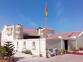
- Narayan Sarovar Temple and Koteshwar Temple
- Ashapura Mata temple at Mata no Madh. The village is located about 100 km from Bhuj. Ashapura Mata is the household deity (Kuldevti) of former Jadeja rulers of Cutch State.
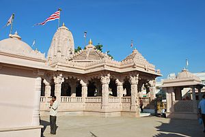
- The Shri Swaminarayan Mandir, Bhuj.
- The Muslims have a following in the Kutch region. Their main dargah-shrine in this district is Shah Zakariya Ali Akbar, Hajipir.
- Anjarcity also has a Swaminarayan Mandir
- Lakhpat has religious significance for three of India's most populous religions.[22]
- The temple of Gudthar Vara Shri Matiya Dev, a deity of the Maheshwari sect, is located in Kutch. Shri Matiya Dev is considered very revered in the Maheshwari sect.
- Siyot Caves
- Mundra[23]
- Khetabapa, Vithon
Important Jain places of Pilgrimage are -
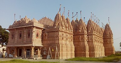
- Shri Bhadreshwar Jain Tirth Derasar[24]
- Koday Jain tirth[25] (72 Jinalaya Jain Temple here is the most famous)
- Vanki Mahavir Jain Temple, Vaanki, Gujarat 370425
- Kothara Shantinath Jain Tirth, Kothara, Abdasa Taluka
- Naliya Thirth Jain Derasar
- Jakhau Mahavirswami Sw. Jain Tirth
- Suthri Dhrutkallol Parshwanath Maha Tirth, Suthari
-
 Narayan Sarovar Temple
 -
 Ashapura Mata Temple, Mata no Madh
 -
 Bhadreshwar
 -
 Lakhpat Gurdwara
 -
 Hajipir Dargah


Education
Higher education in Kutch has been regulated by
Culture
People
Kutch district is inhabited by various groups and communities. One can find various nomadic, semi nomadic and artisan groups living in Kutch. Rabari constitute a comparatively large group in Kutch And there lives a brave and noble community like Ahir.[29]
-
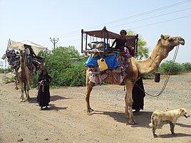 Caravan near Mundra Kutch
 -


Food and drink


Because most of the population of the Kutch district is
The district also features a sizeable population of Muslims, who eat vegetables, chicken, mutton and occasionally camel meat.In the villages of the district, staple foods include
In the region, milk is considered to be a sacred food; an offering of milk is considered a gesture of friendship and welcoming, and dispute settlements invariably involve the parties offering milk to each other. Similarly, in Kutchi engagement ceremonies, the bride's family offers milk to the groom's family as a symbol of accepting their relationship. They also extensively drink buttermilk during lunch.[30]
Tea is the most popular drink in this region.
Economy
Historically Kutch was always considered a backward region due to its location and submerged geography. The situation seemed to have worsened after the disastrous Kutch earthquake in 2001. But in the next decade, the economy took an almost miraculous jump start due to the intense efforts of the Gujarat government. Kutch today is a growing economic and industrial hub in one of India's fastest growing states – Gujarat. Its location on the far western edge of India has resulted in the commissioning of two major ports: Kandla and Mundra. These ports are closest to the Gulf of Arabia (and thus to Europe by sea). The hinterland of north-western India hosts more than 50% of India's population.
Quality of roads is good in Kutch. The large part of the growth of Kutch came after intense development by the state government as part of 2001 earthquake relief.
Due to the existence of two major ports i.e.
Mineral

Kutch is a mineral rich region with a very large reserve of Lignite,[31] Bauxite, Gypsum and other minerals. Kutch received tax break for industries for 15 years after the major earthquake on 26 January 2001. Lignite is mined only by Gujarat Mineral Development Corporation (GMDC) at its two mines in Panandhro and Mata no Madh. The Panandaro mines has now been reserved for GEB and GMDC power plants and GMDC has stopped supplying other industries from there.[32]
Cement and power
Kutch also houses cement plants Gujarat Anjan Cement Limited promoted by infrastructure conglomerate Anjan Group[33] and Sanghi Industries Ltd's promoted by Sanghi Group. The companies are now planning to increase the capacity at Abdasa location from 3–9 million tons per annum.[34] By 2015, the company plans to produce 20 million tons.[34]
Forestry
Kutch district has a scanty forest cover. Hence there is negligible risk of illegal cutting of forests. This coupled with the adequate facilities available at Kandla port has helped establish the timber market. In 1987, "Kandla Timber Association" was formed in order to resolve the specific problems of timber importers and timber allied industries coming up during the period. The timber industry is growing at a faster pace with 300 saw mills working in Gandhidham-Kandla Complex.
Salt

The Little Rann of Kutch is known for its traditional salt production and various references mention this to be a 600-year-old activity. During the British period, this activity increased manifold. It was used to fund a substantial part of the military expenses of the British government.
Communities involved in salt production are mainly Chunvaliya Koli, Ahir and Miyana (Muslim), residing in 107 villages in the periphery of Lesser Rann of Kutch. These communities are traditionally known to have the skills of salt production and are known as 'Agariyas'. Water quality in 107 villages of Lesser Rann of Kutch is saline, thus agriculture is not an option. Hence salt production is the only livelihood option for Agariyas. As per the Salt Commission's report there are 45000 Agariyas working in the salt pans of Kutch. Out of the estimated total annual production of India of about 18 million tonnes, Gujarat contributes 75% – mainly from Kutch and other parts of Saurashtra.
Textile art


Kutch is one of the most prolific regions in India in the area of textile art. Kutch Embroidery is dense with motifs, and a variation with mirrors sewn into the embroidery is one of the signature arts of this region.[citation needed]
Within the category of Kutch embroidery there are several sub-categories as each tribe and sub-tribe produces a unique signature form of art.
Kutchi embroidery is an evolving expression of the craft and textile traditions of the Rabaris, a nomadic tribe in Gujarat. Kutch embroidery is unique in the sense that a net is woven on a cloth using thread. The net is then filled in using the same thread by intricate interlocking stitches. The patterns are usually built around geometric shapes. This embroidery follows its own traditional design logic and juxtaposition of colours and motifs. The Rohanas tribals of Kutch specialise in skirt work. The Sodhas use a geometric style for their embroidery. The Garacia Jats are experts in tiny embroidery on the yoke, which intermingles with red, orange, blue and green threads. The Dhanetah Jats love embroidering broad pear-shaped mirrors using orange, black, yellow and red in chain stitch.
In culture

Just after the film shooting of Refugee finished, the film crew of another Bollywood film Lagaan descended on Bhuj in Kutch and shot the entire film in the region, employing local people and villagers from miles around. A set of a full period Village was constructed for the film with typical Kutch style mud houses or huts with thatched straw roofs called boongas.[37]
Towns and villages
- Anjar
- Bhachau
- Bhuj
- Gandhidham
- Khavda
- Lakhpat
- Madhapar
- Mandvi
- Mundra
- Nakhatrana
- Naliya
- Rapar
- Sonalnagar
See also
- 2001 Gujarat earthquake
- Banni grasslands
- Bhuj, Gandhidham, Mandvi
- Cutch State / Kutch State
- Dabeli
- Kachchh (Lok Sabha constituency)
- Kutchi
- Kutchi language
- Kutchi people
- Princely State of Cutch
- Rann of Kutch
References
- ^ "Kutch" (PDF). Vibrantgujarat.com. Archived from the original (PDF) on 21 October 2012. Retrieved 17 November 2012.
- ^ Sen, Kavita (January 2001). "Economic consequences of the Gujarat earthquake". Academia. Retrieved 21 May 2021.
- ^ a b "About Kutch | About Us | Collectorate - District Kutch". Archived from the original on 27 June 2018. Retrieved 8 February 2016.
- ^ "Census GIS India". Censusindiamaps.net. Archived from the original on 11 January 2010. Retrieved 17 November 2012.
- ^ K̲h̲ān̲, Rānā Muḥammad Sarvar (2005). The Rajputs: History, Clans, Culture, and Nobility. Rana Muhammad Sarwar Khan.
In the seventh century Kachchh formed part of the province of Sindh . Hieun Tsang refers to it as Kiecha . Invasions of Charans , Kathis and Chavadas Rajputs followed . In the ninth century the Arabs settled on the coast .
- ^ Williams, Laurence Frederic Rushbrook (1958). The Black Hills: Kutch in History and Legend: a Study in Indian Local Loyalties. Weidenfeld and Nicolson.
From the eastern quarter, on the mainland, came Charans and Ahirs. These immigrants seem to have divided Kutch between them; their chiefs became territorial barons, with their own strongholds. Soon afterwards, the entire coast of western India was thrown into confusion by the Arab invasion of Sind.
- ^ Shuichi Takezawa (August 2002). "Stepwells – Cosmology of Subterranean Architecture as seen in Adalaj" (PDF). Journal of Architecture and Building Science. 117 (1492): 24. Retrieved 18 November 2009.
- ^ Karanth, R. V.; Gadhavi, M. S. (10 November 2007). "Structural intricacies: Emergent thrusts and blind thrusts of central kachchh, western india" (PDF). Current Science. 93 (9): 1271–1280.
- ^ "Rivers of Kachchh Region". Archived from the original on 8 June 2013.
- ^ "Gujarat: Disaster Management Plan: Operation of gates and rule curve levels for Irrigation Projects" (PDF). Narmada, Water Resources, Water Supply and Kalpsar Department. p. 28.
- ^ "2001 Kutch Earthquake Gujarat State, India: Investigation into Damage to Civil Engineering Structures: Dams" (PDF). The Japan Society of Civil Engineers (JSCE).
- ^ Gupta, Vishal Jaishankar (2011). "Chapter 2. Environmental Outlines of the little Rann of Kutch". Geomorphodynamics and morphoecological management in the little Rann of Kutch (PDF). Maharaja Sayajirao University of Baroda., full document
- ^ Bhagat, Pamela (6 June 2004). "A desert weeps". The Hindu. Archived from the original on 27 June 2004.
- ISBN 9788179911044.
- ^ "Kachchh District Panchayat: Taluka Panchayat". Kutch District. Archived from the original on 15 September 2012.
- ^ "Census of India Website : Office of the Registrar General & Census Commissioner, India". www.censusindia.gov.in. Retrieved 19 August 2019.
- ^ a b "District Census Hand Book – Kutch" (PDF). Census of India. Registrar General and Census Commissioner of India.
- ^ US Directorate of Intelligence. "Country Comparison:Population". Archived from the original on 13 June 2007. Retrieved 1 October 2011.
Macedonia 2,077,328 July 2011 est.
- ^ "2010 Resident Population Data". U. S. Census Bureau. Archived from the original on 19 October 2013. Retrieved 30 September 2011.
New Mexico – 2,059,179
- ^ a b "Population by Religion - Gujarat". censusindia.gov.in. Registrar General and Census Commissioner of India. 2011.
- ^ a b c "Table C-16 Population by Mother Tongue: Gujarat". censusindia.gov.in. Registrar General and Census Commissioner of India.
- ^ "Lakhpat, Islam, Sikhism, Kutch, Tourism Hubs, Gujarat, India". www.gujarattourism.com. Archived from the original on 19 August 2019. Retrieved 19 August 2019.
- ^ "Mundra, Port Town, Kutch, Tourism Hubs, Gujarat, India". www.gujarattourism.com. Archived from the original on 19 August 2019. Retrieved 19 August 2019.
- ^ "Bhadreshwar, Jainism, Mandvi, Kutch, Tourism Hubs, Gujarat, India". www.gujarattourism.com. Archived from the original on 19 August 2019. Retrieved 19 August 2019.
- ^ "Koday, Jain Temple, Mandvi - Kutch, Jainism, Tourism Hubs, Gujarat, India". Archived from the original on 31 August 2014.
- ^ "Kutch Uni. Index_comb_.doc" (PDF). Archived from the original (PDF) on 16 June 2022. Retrieved 22 March 2015.
- ^ "List of Affiliated Colleges Up to 2013-14" (PDF). KRANTIGURU SHYAMJI KRISHNA VERMA KACHCHH UNIVERSITY.
- ^ "Gujarat Technological University". Archived from the original on 21 April 2012. Retrieved 25 April 2012.
- ^ Hawabai Mustafa Shah. "Aboriginal Tribes of India And Pakistan: The Bhils & Kolhis" (PDF). Academy of the Punjab in North America.
- ^ a b c "Food & Drink". District Kachchh, Government of Gujarat. Retrieved 16 May 2021.
- ^ Chakravarti, V.K. (15–28 March 2003). "The brown gold of Kutch – By tapping the huge mineral deposits of the Kutch region, Gujarat Mineral Development Corporation Ltd. plans to turn the backward area into a prosperous one". Frontline Magazine. Archived from the original on 7 November 2012. Retrieved 19 August 2019.
- ^ http://steelguru.com/news/index/2008/08/10/NTgyNzg%3D/GMDC_to_soon_start_lignite_mining_at_4_locations_in_Gujarat.html[permanent dead link]
- ^ "ANJAN GROUP - INFRASTRUCTURE FOR LIFE". 1 August 2015. Archived from the original on 1 August 2015.
- ^ a b "SIL to set up cement plant in Kutch". The Times of India. Ahmedabad. 30 June 2007. Archived from the original (cms) on 3 January 2013.
- ^ Love Across the Salt Desert Archived 2 December 2013 at the Wayback Machine; by Keki N. Daruwalla. Pdf of full story posted at Boston University at [1] Archived 19 July 2011 at the Wayback Machine. Bollywood connection – J. P. Dutta's "Refugee" is said to be inspired by this story Archived 2 December 2013 at the Wayback Machine; learnhub, University of Dundee
- NCERT. Also posted at [2] / [3], "Archived copy". Archived from the original on 10 April 2009. Retrieved 6 January 2010.)
{{cite web}}: CS1 maint: archived copy as title (link - ISBN 81-7991-003-2(3749)
External links
- Official website
- Katch District Collectorate
- Katch District Panchayat
- of Kutch Peninsula and the Great Rann; The Geological Survey of India, Ministry of Mines, Government of India
 Geographic data related to Kutch district at OpenStreetMap
Places adjacent to Kutch district | ||||||||||||||||
|---|---|---|---|---|---|---|---|---|---|---|---|---|---|---|---|---|
| ||||||||||||||||
| Topics |
|  |
|---|---|---|
| Regions of Gujarat | ||
| Districts | ||
| Major cities | ||
| Ecoregions |
| |
| Economy |
| |
| International | |
|---|---|
| National | |