
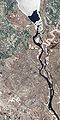
Kyiv Reservoir
| Kyiv Reservoir | |
|---|---|
Dnieper River | |
| Basin countries | Russia, Belarus, Ukraine |
| Max. length | 110 km (68 mi) |
| Max. width | 12 km (7.5 mi) |
| Surface area | 922 km2 (356 sq mi) |
| Max. depth | 8 m (26 ft) |
| Water volume | 3.7 km3 (0.89 cu mi) |
| Surface elevation | 99 m (325 ft) |
 | |

The Kyiv Reservoir (
The reservoir is 110 km in length, 12 km in width, has a depth of four to eight meters, a volume of 3.7 km3 (0.89 cu mi), and a usable volume of 1.2 km3 (0.29 cu mi). The reservoir, together with the Kakhovka Reservoir, the Dnieper Reservoir, the Kamianske Reservoir, the Kremenchuk Reservoir, and the Kaniv Reservoir, has created a deep-water route on the river. However, its creation has also contributed to significant environmental problems such as the diminished flow velocity which reduces water oxygenation, and has a negative result on the balance of aquatic life forms. Also, some nearby villages were flooded when it filled. One of these was Teremtsi, where the residents of the village persuaded Soviet authorities to let them stay, only to be evacuated later in 1986 during the Chernobyl disaster.
Safety issues
Like
A similar threat was permanently discussed regarding the potential destruction of the dam (by natural accident, terrorism or war). But the authorities continued to dismiss such dangers as unreal, claiming to be in full control of the dam's safety. However, serious concerns were raised in 2005, when a fake terrorist alert was made.[citation needed]
Worries about possible destruction arose again in February 2022 during the
Gallery
-
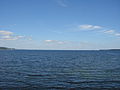
 The reservoir's surface is a combination of ice-covered and ice-free areas in this springtime image.
 -

-

-
-


See also
- Dnieper reservoir cascade
References
- ^ "Kyiv hydroelectric power plant controlled by Russian troops - Ifax". Reuters. 2022-02-26. Retrieved 2022-02-26.
- ^ "Київська ГЕС повністю під контролем України – міністр енергетики". Інтерфакс-Україна (in Ukrainian). Archived from the original on 26 February 2022. Retrieved 2022-02-26.
- ^ "Українські ППО збили ракету, що летить у бік дамби Київського водосховища, - "Укрводшлях", Мінінфраструктури". Інтерфакс-Україна (in Ukrainian). Archived from the original on 26 February 2022. Retrieved 2022-02-26.
External links
- Information about the reservoir at the Wayback Machine (archived October 27, 2009)
- “Аргументы и факты” о реальных угрозах дамбы Киевского водохранилища и ГЭС Archived 2021-01-25 at the Wayback Machine
- “Известия” о проблематике плотины Киевского водохранилища и ГЭС
- Эксперт УНИАН об угрозах дамбы Киевского водохранилища
| Tributaries1 |  | |
|---|---|---|
| Reservoirs | ||
| Hydroelectric stations |
| |
| Canals | ||
| Cities | ||
| Crossings |
| |
| ||