
Kyustendil
Kyustendil
Кюстендил | |
|---|---|
Town | |
 | |
|
KH |
Kyustendil (Bulgarian: Кюстендил [kʲustenˈdiɫ]) is a town in the far west of Bulgaria, the capital of the Kyustendil Province, a former bishopric and present Latin Catholic titular see.
The town is situated in the southern part of the
Names
The modern name is derived from Kösten, the Turkified name of the 14th-century Serbian magnate
Eponymy
Kyustendil Ridge in Graham Land, Antarctica is named after the city,[3] and Pautalia Glacier on Livingston Island in the South Shetland Islands, Antarctica is named after Pautalia (its Thracian ancestor settlement).[4]
History
Prehistory and Roman era
A
Under the name Pautalia (

In the 1st century AD, it was administratively part of Macedonia. Later the city was part of the province of Dacia Mediterranea and the third largest city in the province.
The Roman fortress of Pautalia of the 2nd to 4th century had an area of over 29 hectares (appr. 72 acres). The fortress wall was built mainly of granite blocks and unusually its façade was supported with pillars and arches behind. The wall was 2.5m wide allowing small catapults to be mounted atop.
A second, smaller fortress of area 2 hectares was built in the town in the 4th century (known by its later Ottoman name Hisarlaka).
Many Thracian and Roman objects are exhibited in the town's Regional History Museum, most notably an impressive numismatic collection.
Recent excavations have revealed an early Christian, late Roman monumental bishop's palace.[7]
Middle Ages
The town was mentioned under the

In 1282, Serbian king Stefan Milutin defeated the Byzantine Empire and conquered Velbazhd.
In 1330,
Ottoman era

The city was a
Modern
The residents of Kyustendil took an active part in the
Demographics
According to the 2021 census, the population of Kyustendil is 37,799 people.[14]
Ethnic linguistic and religious composition
According to the 2011 census data, people who chose to declare their ethnic identity were distributed as follows:[15][16]
- Bulgarians: 36,732 (82.5%)
- Roma: 5,179 (11.6%)
- Turks: 2 (0.0%)
- Others: 143 (0.3%)
- Indefinable: 296 (0.7%)
- Undeclared: 2,161 (4.9%)
Total: 44,513
Roma people are mainly concentrated within the town limits. In the meantime, about a fourth of Bulgarians live in the surrounding villages, also part of the Municipality of Kyustendil.
Religion
Kyustendil today belongs to the Sofia diocese in regards of Orthodox church-administrative structure. The city is the center of the vicarage and the Kyustendil Eparchy; in the past, Kyustendil was the seat of the diocese, that latter was closed in 1884. The majority of the urban population profess the Orthodox faith today.
There are several Christian denominations associated with Protestantism and a small Jewish community. During Ottoman rule Kyustendil had a population mostly professing Islam, but of the many mosques of the time, now only two remain. Today the city has only Christian churches operating.
In Antiquity, Pautalia was a bishopric in the
- Evangelius, who was summoned to Constantinople by Byzantine emperor Anastasius I Dicorus in 516 during the controversy against Monophysitism.
During the brief Late Medieval period, when the Bulgarian Church entered in full communion with Rome (instead of Orthodox Constantinople), one of its three 'Uniate Catholic' (equivalent to modern
Latin Titular see
The archdiocese was nominally restored in 1933 as Latin Metropolitan
It has had the following incumbents, so far of the fitting Metropolitan (highest; perhaps some merely of intermediary Archiepiscopal) rank :
- Diocese of Seckau (Austria) (1927.02.25 – 1927.04.26), succeeded as Bishop of Seckau (1927.04.26 – 1953.12.07)
- Salisbury(now Harare, Zimbabwe) (1955.01.01 – 1956.11.23)
- Uberaba (Brazil) (1924.07.04 – 1928.12.17), Bishop of Corumbá (Brazil) (1928.12.17 – 1931.07.10), Metropolitan Archbishop of Belém do Pará (Brazil) (1931.07.10 – 1941.07.19), Metropolitan Archbishop of Fortaleza(Brazil) (1941.07.19 – 1963.02.16); died 1976
- (Papua New Guinea) (1966.11.15 – retired 1971.06.05), died 1992
- ) (1972.06.26 – 1975.04.10), next succeeded as Metropolitan Archbishop of Kaduna (1975.04.10 – retired 2007.11.16)
- Lanciano (Italy) (1982.05.13 – 1986.09.30), restyled first Archbishop of Lanciano–Ortona(Italy) (1986.09.30 – retired 2000.11.25)
- Auxiliary Bishop of Madrid(Spain) (1972.09.05 – 1983.07.30)
- Archbishop Apostolic Nuncio to Belarus, no previous prelature.
Economy
The city is the center of light and manufacturing industry: logging, footwear, knitwear, ready-made clothes, toys, packaging, alcohol producers, bakery, printing and canning industries. There are companies for the production of condensers, power transformers, household and kitchen furniture and joinery. Hotels and tourism have evolved in recent years. The region has traditions in fruit growing and trade in fresh and dried fruits.
Kyustendil is a center of an agricultural area with centuries-old traditions in the field of fruit growing, which is why the town and its surroundings are known as the "Orchard Garden of Bulgaria".[citation needed]
Geography
Kyustendil is a national
Kyustendil is located at the foot of the
Climate
Kyustendil has a temperate climate with mediterranean and continental influence (because of the Struma river). The average annual temperature is around 13 °C (55 °F). The highest average temperatures are in July and August at 22 to 23 °C (72–73 °F) and lowest in January at 1 to 2 °C (34–36 °F). The annual temperature range is 23 °C (41 °F).Summers are hot and long, winters are short and cool, spring comes early and stays steady after the first days of March and the autumn is long, warm and sunny while maintaining stable until the end of November. Rainfall is moderate – average 604 mm (23.8 in), and there is snow on average 10–12 days in winter, although it may vary significantly. Due to moderately severe cloudy and hazy low (average 20 days per year) duration of sunshine is significant – about 2,300 hours per year. The second half of the summer and early autumn in the town are the sunniest of the year, and the cloud cover is mostly in the winter months. Humidity is moderate. It varies between 65 and 70%, and is relatively low in the summer months (especially in August). Kyustendil valley is characterized by low windiness, spring being the most windy season and autumn the most quiet. The average annual wind speed is 1.4 m/s (4.6 ft/s). During the winter and spring months in the city appears warm and gusty wind "foehn", which causes sudden warming of time. The temperature regime is characterized by some special features. Winter temperature inversions occur, and in the summer as a result of overheating of the daily maximum air temperatures rise to 35 to 38 °C (95–100 °F). Summer nights are mild or warm with temperatures in the range of 18 to 23 °C (64–73 °F), although temperatures tend to drop below 19 °C (66 °F) in the early mornings for about two hours. The lowest temperature in the city is measured on 20 January 1967 at −22.4 °C (−8.3 °F), and the highest 43.2 °C (110 °F) reached both in July and August, most recently on 24 July 2007.
| Climate data for Kyustendil, Bulgaria (2010–2022) | |||||||||||||
|---|---|---|---|---|---|---|---|---|---|---|---|---|---|
| Month | Jan | Feb | Mar | Apr | May | Jun | Jul | Aug | Sep | Oct | Nov | Dec | Year |
| Mean daily maximum °C (°F) | 6.2 (43.2) |
8.7 (47.7) |
13.5 (56.3) |
18.9 (66.0) |
24.0 (75.2) |
28.1 (82.6) |
31.8 (89.2) |
31.5 (88.7) |
26.2 (79.2) |
20.1 (68.2) |
13.5 (56.3) |
7.5 (45.5) |
19.2 (66.6) |
| Daily mean °C (°F) | 1.5 (34.7) |
2.5 (36.5) |
7.5 (45.5) |
12.4 (54.3) |
17.6 (63.7) |
21.2 (70.2) |
24.0 (75.2) |
23.5 (74.3) |
19.0 (66.2) |
13.4 (56.1) |
7.8 (46.0) |
2.0 (35.6) |
13.0 (55.4) |
| Mean daily minimum °C (°F) | −3.3 (26.1) |
−2.3 (27.9) |
2.5 (36.5) |
7.0 (44.6) |
10.5 (50.9) |
14.1 (57.4) |
15.8 (60.4) |
15.5 (59.9) |
12.1 (53.8) |
7.5 (45.5) |
2.8 (37.0) |
−1.4 (29.5) |
7.1 (44.8) |
| Average precipitation mm (inches) | 48 (1.9) |
45 (1.8) |
42 (1.7) |
52 (2.0) |
68 (2.7) |
65 (2.6) |
54 (2.1) |
36 (1.4) |
38 (1.5) |
59 (2.3) |
62 (2.4) |
55 (2.2) |
624 (24.6) |
| Average precipitation days (≥ 0.1 mm) | 10 | 9 | 8 | 8 | 9 | 8 | 4 | 4 | 6 | 7 | 8 | 11 | 92 |
| Average snowy days (≥ 0.1 cm) | 4 | 3 | 1 | 0 | 0 | 0 | 0 | 0 | 0 | 0 | 1 | 3 | 12 |
| Mean monthly sunshine hours | 85 | 117 | 168 | 214 | 261 | 314 | 323 | 312 | 223 | 151 | 106 | 75 | 2,349 |
| Source: Stringmeteo.com[17] | |||||||||||||
| Kyustendil | ||||||||||||||||||||||||||||||||||||||||||||||||||||||||||||
|---|---|---|---|---|---|---|---|---|---|---|---|---|---|---|---|---|---|---|---|---|---|---|---|---|---|---|---|---|---|---|---|---|---|---|---|---|---|---|---|---|---|---|---|---|---|---|---|---|---|---|---|---|---|---|---|---|---|---|---|---|
| Climate chart (explanation) | ||||||||||||||||||||||||||||||||||||||||||||||||||||||||||||
| ||||||||||||||||||||||||||||||||||||||||||||||||||||||||||||
| ||||||||||||||||||||||||||||||||||||||||||||||||||||||||||||
Notable people
- Constantine Dragaš, 14th-century local Serbian ruler
- Ilyo Voyvoda (1805–1898), hajduk, revolutionary and Bulgarian liberation fighter (died in Kyustendil)
- Vladimir Dimitrov (1882–1960), painter
- Bulgarian Jewsto Nazi death camps
- Belgian resistancefighter
- Nikolay Diulgheroff (1901–1982), futurist artist
- Marin Goleminov (1908–2000), composer
- Irina Taseva (1910–1990), Bulgarian actress
Gallery
-
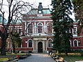 The municipality hall (architect Friedrich Grünanger)
 -
 The municipality hall
 -
 10th-11th-century Church of St George in the Kolusha neighbourhood
 -
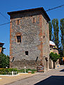
 Timber-framedtower
 -
 Fatih Mehmet Mosque (15th century)
 -
 Cifte Spa Bath
 -
 The 15th-16th-century Pyrgos Tower
 -
 The Hisarlaka medieval fortress lying atop a hill overlooking the town
 -
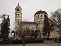 The Church of Saint Menas, built in 1859, situated in the west part of Kystendil.
 -
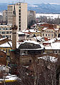
 Building in Kyustendil


.jpg)

.JPG)
See also
- FC Velbazhd Kyustendil(Pautalia during World War II)
- List of Catholic dioceses in Bulgaria
References
- ^ Ćorović 2001, ch. 3, XIII. Boj na Kosovu
- ^ Матанов, Христо (1986). "Феодални княжества и владетели през последните десетилетия на XIV век". Югозападните български земи през XIV век (in Bulgarian). София: Наука и изкуство. p. 126.
- Composite Antarctic Gazetteer.
- Composite Antarctic Gazetteer.
- ^ Joseph Hilarius Eckhel, Doctrina numorum veterum, vol. ii. p. 38
- ^
 Smith, William, ed. (1854–1857). "Pautalia". Dictionary of Greek and Roman Geography. London: John Murray.
- ^ "Archaeologists Discover Residence of Early Christian Bishop of Ancient Roman City Pautalia in Bulgaria's Kyustendil". 28 April 2018. Archived from the original on 20 September 2019. Retrieved 28 April 2018.
- ^ ISBN 0-7864-2248-3McFarland & Company (2005)
- ^ Mihaljčić 1989, pp. 79-81
- ^ Fajfric, 42
- ^ Samardzic 1892 p. 22:
Синови деспота Дејана заједнички су управљали пространом облашћу у источној Македонији, мада је исправе чешће потписивао старији, Јован Драгаш. Као и његов отац, Јован Драгаш је носио знаке деспотског достојанства. Иако се као деспот помиње први пут 1373, сасвим је извесно да је Јован Драгаш ову титулу добио од цара Уроша. Високо достојанство убрајало се, како је …
- ^ Fine 1994, p. 358
- ^ Edition de l'Académie bulgare des sciences, 1986, "Balkan studies, Vol. 22", p. 38
- ^ "Население по градове и пол | Национален статистически институт". nsi.bg. Retrieved 3 January 2024.
- ^ "Population by age". Archived from the original on 8 September 2013.
- ^ "Population by ethnos". Archived from the original on 21 May 2013.
- ^ Stringmeteo.com Retrieved May 4, 2013.
- ^ "Фактически данни » начало". www.stringmeteo.com. Retrieved 3 January 2024.
Sources and external links
 Media related to Kyustendil at Wikimedia Commons
- Kyustendil District Administration Provides information about the region, photos, historical review, and development projects Archived 2016-03-03 at the Wayback Machine
- Kyustendil tourist destination – tourism opportunities in the Kyustendil region
- Kustendil Info, Information web Portal of Kyustendil
- KnCity.info, a website about Kyustendil
- Kyustendil at Journey.bg
- Kyustendil at BGGlobe
- Regional History Museum
- GCatholic - former (Pautalia) & titular see of Velebusdus
- Bibliography - ecclesiastical history
- Pius Bonifacius Gams, Series episcoporum Ecclesiae Catholicae, Leipzig 1931, pp. 417 e 432
- Daniele Farlati-Jacopo Coleti, Illyricum Sacrum, vol. VIII, Venece 1817, p. 77 e p. 246
- Konrad Eubel, Hierarchia Catholica Medii Aevi, vol. 1, p. 130
- Jacques Zeiller, Les origines chrétiennes dans les provinces danubiennes de l'empire romain, Paris 1918, p. 160
![]() This article incorporates text from a publication now in the public domain: Smith, William, ed. (1854–1857). "Pautalia". Dictionary of Greek and Roman Geography. London: John Murray.
This article incorporates text from a publication now in the public domain: Smith, William, ed. (1854–1857). "Pautalia". Dictionary of Greek and Roman Geography. London: John Murray.
Places adjacent to Kyustendil | ||||||||||||||||
|---|---|---|---|---|---|---|---|---|---|---|---|---|---|---|---|---|
| ||||||||||||||||

| International | |
|---|---|
| National | |
| Geographic | |