
L'Anse, Michigan
L'Anse, Michigan | ||
|---|---|---|
FIPS code 26-45540[2] | | |
| GNIS feature ID | 629897[3] | |
| Website | villageoflanse | |
L'Anse (
History
This area was long occupied by people of the Lake Superior Band of Ojibwa (Chippewa),[6] who called it "Gichi-wiikwedong".[10] Much later, French colonists had established a fur trading post here as a part of New France and a Jesuit mission, naming it L'Anse. In French, L'Anse translates as "the cove" or "the bay", a reference to its location in on the southern portion of L'Anse Bay, a portion of the larger Keweenaw Bay, at the base of the Keweenaw Peninsula. The modern-day village grew around this French trading post.[5][8][11]
Following treaties with the United States in the 19th century, the Ojibwa/Chippewa ceded extensive amounts of land in Michigan. The L'Anse Indian Reservation was established by the U.S. here as the largest and the oldest in Michigan.[11]
In 1896, the village was completely burned to the ground by a deadly fire which left many homeless.[6][12]
Geography
According to the United States Census Bureau, the village has a total area of 2.53 square miles (6.55 km2), all of it land.[13]
Attractions
- The L'Anse Waterfront Park on Baraga Avenue within the downtown area is a nice and scenic location to rest.[14][15]
- The Falls River Falls in downtown L'Anse is a very long series of cascading falls that spans the entire width of the Falls River.[16][17]
Demographics
| Census | Pop. | Note | %± |
|---|---|---|---|
| 1880 | 1,014 | — | |
| 1890 | 655 | −35.4% | |
| 1900 | 620 | −5.3% | |
| 1910 | 708 | 14.2% | |
| 1920 | 1,013 | 43.1% | |
| 1930 | 2,421 | 139.0% | |
| 1940 | 2,564 | 5.9% | |
| 1950 | 2,376 | −7.3% | |
| 1960 | 2,397 | 0.9% | |
| 1970 | 2,538 | 5.9% | |
| 1980 | 2,500 | −1.5% | |
| 1990 | 2,151 | −14.0% | |
| 2000 | 2,107 | −2.0% | |
| 2010 | 2,011 | −4.6% | |
| 2020 | 1,874 | −6.8% | |
| U.S. Decennial Census[18] | |||
2020 census
As of the
2010 census
At the 2010
There were 874 households, of which 28.1% had children under the age of 18 living with them, 40.0% were married couples living together, 12.2% had a female householder with no husband present, 5.1% had a male householder with no wife present, and 42.6% were non-families. 37.9% of all households were made up of individuals, and 16.4% had someone living alone who was 65 years of age or older. The average household size was 2.16 and the average family size was 2.82.
The median age was 41.7 years. 22.9% of residents were under the age of 18; 6.8% were between the ages of 18 and 24; 24.3% were from 25 to 44; 24.1% were from 45 to 64; and 21.8% were 65 years of age or older. The gender makeup of the village was 47.6% male and 52.4% female.
2000 census
At the 2000
There were 894 households, of which 25.6% had children under the age of 18 living with them, 46.4% were married couples living together, 9.8% had a female householder with no husband present, and 39.5% were non-families. 34.2% of all households were made up of individuals, and 16.2% had someone living alone who was 65 years of age or older. The average household size was 2.23 and the average family size was 2.86.
21.3% of the population were under the age of 18, 7.3% from 18 to 24, 25.6% from 25 to 44, 23.9% from 45 to 64, and 21.9% who were 65 years of age or older. The median age was 42 years. For every 100 females, there were 88.8 males. For every 100 females age 18 and over, there were 87.3 males.
The
Transportation
 US 41 runs through the southernmost portion of the village.[5]
 M-38 begins in the Village of Baraga, across the bay from L'Anse.
- The bus line Milwaukee, Wisconsin, with a stop in L'Anse.[20]
Gallery
-
 The L'Anse Waterfront Park is in the village on the shore of Lake Superior
 -
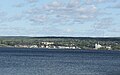 A view across the Keweenaw Bay to L'Anse.
 -
 the L'Anse Intersection on US 41
 -
 The sign for L'Anse on US 41
 -
 Going through L'Anse
 -
 The L'Anse Township Hall
 -
 The Baraga County Courthouse and Annex is located in L'Anse.
 -
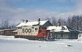 A train of the now-defunct Soo Line Railroad at L'Anse in 1967.


.jpg)
References
- ^ "2020 U.S. Gazetteer Files". United States Census Bureau. Retrieved May 21, 2022.
- ^ a b "U.S. Census website". United States Census Bureau. Retrieved January 31, 2008.
- ^ U.S. Geological Survey Geographic Names Information System: L'Anse, Michigan
- ^ "Find a County". National Association of Counties. Retrieved June 7, 2011.
- ^ ISBN 0-942363-04-3.)
{{cite book}}: CS1 maint: location missing publisher (link - ^ a b c The History of L'Anse Township by the American History Class of L'Anse High School. L'Anse, Michigan: L'Anse Sentinel. 1922.
- ^ a b "2020 Decennial Census: L'Anse village, Michigan". data.census.gov. U.S. Census Bureau. Retrieved July 24, 2022.
- ^ ISBN 978-1-938229-17-6.
- ^ "About Us - Natural Resource Department". nrd.kbic-nsn.gov. Keweenaw Bay Indian Community. Retrieved July 24, 2022.
- ^ "Gidakiiminaan (Our Earth)" (PDF). Great Lakes Indian Fish and Wildlife Commission. Retrieved May 10, 2023.
- ^ a b hostmaster (November 16, 2016). "L'Anse". Michigan. Retrieved May 1, 2019.
- ^ "L'Anse, Michigan". www.baragacountyhistoricalmuseum.com. Retrieved May 1, 2019.
- ^ "US Gazetteer files 2010". United States Census Bureau. Archived from the original on January 12, 2012. Retrieved November 25, 2012.
- ^ "L'Anse Waterfront Park". Baraga County. Retrieved May 5, 2019.
- ^ "L'Anse Waterfront Park - 2019 All You Need to Know BEFORE You Go (with Photos)". TripAdvisor. Retrieved May 5, 2019.
- ^ "Falls River Falls". gowaterfalling.com. Retrieved May 5, 2019.
- ISBN 978-1-59193-771-5.
- ^ "Census of Population and Housing". Census.gov. Retrieved June 4, 2015.
- ^ "U.S. Census website". United States Census Bureau. Retrieved November 25, 2012.
- ^ "HANCOCK-MARQUETTE-GREEN BAY-MILWAUKEE" (PDF). Indian Trails. January 12, 2012. Archived from the original (PDF) on February 22, 2014. Retrieved February 27, 2013.
Further reading
- Baragaland Bicentennial 1776-1976. Baraga, Michigan: The Lumberjacks. 1976.
- 100 Years of History: L'Anse/Skanee Centennial. Ishpeming, Michigan: Baraga County Historical Society Pageant Division. 1971.
External links
Municipalities and communities of Baraga County, Michigan, United States | ||
|---|---|---|
| Villages |  | |
| Civil townships | ||
| CDPs | ||
| Other communities | ||
| Indian reservations | ||
| Footnotes | ‡This populated place also has portions in an adjacent county or counties | |
| ||
| Central cities | |
|---|---|
| Counties | |
| Geography | |
| Transportation | |
| Economy | |
| International | |
|---|---|
| National | |
| Geographic | |