Lácar Lake
| Lácar Lake | |
|---|---|
 | |
| Location | Lácar Department, Neuquén Province |
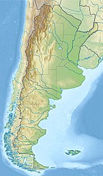
| Coordinates | 40°11′S 71°32′W / 40.183°S 71.533°W |
| Type | glacial lake |
| Primary outflows | Huahum River |
| Catchment area | 1,048 km2 (405 sq mi) |
| Basin countries | Argentina |
| Surface area | 55 km2 (21 sq mi) |
| Average depth | 167 m (548 ft) |
| Max. depth | 277 m (909 ft) |
| Water volume | 9.19 km3 (2.20 cu mi) |
| Surface elevation | 630 m (2,070 ft) |
| Settlements | San Martín de los Andes |
Lácar Lake (
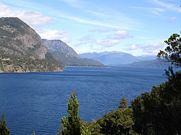
Boundary treaty of 1881 between Chile and Argentina.[2] The lake, along with the smaller lake nearby, Lolog, has some sacred significance for the Mapuche people, as it features in their oral tradition as part of a creation myth.[3] Large sections of the lake's shores are made of cliffs.[1]
The dominant species of plankton in the lake is Aphanocapsa elachista.[1]
References
- ^ a b c Thomasson, Kuno (1963). "Lake Lacár". Araucanian Lakes: Plankton Studies in North Patagonia with Notes on Terrestrial Vegetation. Uppsala: Almqvist & Wiksell. p. 75.
- ^ The Cordillera of the Andes Boundary Case (Argentina, Chile) United Nations
- ^ Charles David Tilley Bilbao (2016). "Serpientes, espíritus y hombres el relato mapuche de Treng-Treng y Kay- Kay". TRIM: Tordesillas, revista de investigación multidisciplinar (in Spanish) (10).
External links

