
Lääne County
(Redirected from
Läänemaa
)Lääne County
Läänemaa | |
|---|---|
 | |
|
Flag  Coat of arms | |
 | |
| Country | |
| Capital | |
| Government | |
| • Governor | Innar Mäesalu |
| Area | |
| • Total | 2,383 km2 (920 sq mi) |
| Population (2022[1]) | |
| • Total | 20,227 |
| • Rank | 14th |
| • Density | 10.3/km2 (27/sq mi) |
| Ethnicity | |
| • Estonians | 89.3% |
| • Russians | 7.4% |
| • other | 3.3% |
| GDP | |
| • Total | €320 million (2022) |
| • Per capita | €15,658 (2022) |
| ISO 3166 code | EE-56 |
| Vehicle registration | S |
| Website | www |
Lääne County (
Latin: Rotalia) is one of the 15 counties of Estonia. It is located in western Estonia and borders the Baltic Sea to the north, Harju County to the north-east, Rapla County to the east, Pärnu County to the south, and the island counties of Saare and Hiiu to the west. In January 2009 Lääne County had a population of 23,810 – constituting 2.0% of the total population in Estonia.[1]
County government
The
County Government (Estonian: Maavalitsus) is led by a governor (Estonian: maavanem), who is appointed by the Government of Estonia
for a term of five years. Since 15 December 2011, the governorship has been held by Innar Mäesalu.
Maavanem 1918–1941
Maavanem 1993–present
- Andres Lipstok 14 December 1993 – 12 August 1994[3]
- Hannes Danilov 1 November 1994 – 3 January 1999[3]
- Arder Väli 23 February 1999 – 20 July 1999[3]
- Jaanus Sahk 22 September 1999 – 22 September 2004[3]
- Sulev Vare 19 November 2004 – 14 September 2007[3]
- Neeme Suur 18 February 2008 – 4 April 2011[3]
- Innar Mäesalu 15 December 2011 -[4]
Municipalities
The county is subdivided into municipalities. There is one urban municipality, Haapsalu (Estonian: linn – town) and 2 rural municipalities (Estonian: vallad – parishes) in Lääne County.

| Rank | Municipality | Type | Population (2018)[5] |
Area km2[5] |
Density[5] |
|---|---|---|---|---|---|
| 1 | Haapsalu | Urban | 13,516 | 264 | 51.2 |
| 2 | Lääne-Nigula Parish | Rural | 7,239 | 1,451 | 5.0 |
| 3 | Vormsi Parish | Rural | 419 | 93 | 4.5 |
Religion
Religion in Lääne County (2021) [1]
Unaffiliated (74.9%)
Lutheran (11.4%)
Orthodox & Old Believers (7.5%)
Baptism (2.6%)
Others Christians (2.0%)
Others Religions or Unknown (1.2%)
| Religion | 2000 | 2011 | 2021 | |||
|---|---|---|---|---|---|---|
| Number | % | Number | % | Number | % | |
| Christianity | 5,109 | 22,3 | 4,418 | 21.3 | 4,050 | 23.6 |
| —Orthodox Christians | 921 | 4.0 | 1,052 | 5.0 | 1,290 | 7.4 |
| — Lutherans |
3,580 | 15.6 | 2,773 | 13.4 | 1,960 | 11.4 |
| — Catholics |
46 | 0.2 | 32 | 0.1 | 40 | 0.2 |
| —Baptists | 358 | 1.5 | 234 | 1.1 | 450 | 2.6 |
| —Jehovah's Witnesses | 74 | 0.3 | 93 | 0.4 | 90 | 0.5 |
| — Pentecostals |
70 | 0.3 | 46 | 0.2 | 80 | 0.4 |
| —Old Believers | - | 3 | 0.01 | - | ||
| — Methodists |
73 | 0.3 | 36 | 0.1 | 20 | 0.1 |
| — Adventists |
61 | 0.2 | 46 | 0.2 | 50 | 0.3 |
| —Other Christians | - | 103 | 0.5 | 70 | 0.3 | |
| Islam | 12 | 0.05 | 8 | 0.02 | - | |
| Buddhism | - | - | 14 | 0.04 | - | |
| Other religions** | 98 | 0.4 | 210 | 1.0 | 200 | 1.1 |
| No religion | 8,632 | 37.8 | 13,126 | 64.5 | 10,920 | 63.6 |
| Not stated*** | 8,914 | 39.0 | 2,798 | 13.5 | 1,940 | 11.3 |
| Total population* | 22,840 | 20,673 | 17,170 | |||
| *The censuses of Estonia count the religious affiliations of the population older than 15 years of age.[6] ".[6] | ||||||
History
Rotalia Läänemaa | |||||||||
|---|---|---|---|---|---|---|---|---|---|
| Viking Age–1224 | |||||||||
Council of Elders | |||||||||
| Elder | |||||||||
| History | |||||||||
• Established | Viking Age | ||||||||
• Disestablished | 1224 | ||||||||
| |||||||||
Ugaunia).[7]
Läänemaa (
Bishopric of Ösel-Wiek, an independent Bishopric. Parts of the Bishop's castle are still preserved in Haapsalu
.
Historic parishes (kihelkonnad)
- Hanila
- Cozzo (Karuse)
- Corbe (Kõrve)
- Lihula
- Ridala
- Soontagana (et:Soontagana)
- around Märjamaa
After the German conquest in 1227, Lääne County became the center of the
Livonian Confederation. Parts of Bishop's castle are still preserved in Haapsalu
.
Gallery
-

-
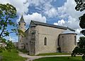 Haapsalu Castle church
 -
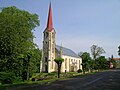 Lihula church
 -
 Haapsalu Kuursaal
 -
 Noarootsichurch
 -
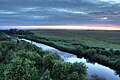 Kasari river in Matsalu National Park
 -

-

-
 Ungru Castle in Kiltsi
 -
 Koluvere manor
 -
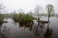
 Marimetsa bog
 -
 Cliff on the island of Osmussaar
 -
 Matsalu Bay coastline on the Puise Peninsula
 -
 Kasari river
 -


.JPG)


See also
References
- ^ a b "Population by sex, ethnic nationality and County, 1 January". stat.ee. Statistics Estonia. 1 January 2009. Retrieved 2009-10-18.
- ^ "GROSS DOMESTIC PRODUCT BY COUNTY". stat.ee.
- ^ a b c d e f g h "Endised maavanemad - Lääne Maavalitsus". Archived from the original on 2014-01-12. Retrieved 2013-04-17.
- ^ "Maavanem - Lääne Maavalitsus". Archived from the original on 2014-01-12. Retrieved 2013-04-17.
- ^ a b c "Elanike demograafiline jaotus maakonniti". Kohaliku omavalitsuse portaal. Archived from the original on 2 March 2019. Retrieved 2 April 2018.
- ^ a b c Official census data from Statistics Estonia:
- 2000 Census:
- 2011 Census:
- 2021 Census:
- ^ ISBN 0-8179-2852-9.
External links
Wikimedia Commons has media related to Lääne County.
- Läänemaa Portal (in Estonian)
- Lääne County Government Official website (in Estonian)
Geographic locale | ||||||||||||||||||
|---|---|---|---|---|---|---|---|---|---|---|---|---|---|---|---|---|---|---|
| ||||||||||||||||||
58°55′N 23°45′E / 58.917°N 23.750°E
| Authority control databases: Geographic |
|---|