
Lake Cahuilla
| Lake Cahuilla | ||
|---|---|---|
Primary inflows Colorado River | San Felipe Creek Whitewater River | |
| Primary outflows | Hardy River | |
| Max. length | 160 km2 (62 sq mi) | |
| Max. width | 56 km2 (22 sq mi) | |
| Surface area | 5,700 km2 (2,200 sq mi) | |
| Average depth | 91 m (299 ft) at a surface elevation of 12 meters | |
| Surface elevation | 7.6–18.3 m (25–60 ft) | |
| Islands | 6 | |
Lake Cahuilla (/kəˈwiː.ə/ kə-WEE-ə;[1][2][3] also known as Lake LeConte and Blake Sea) was a prehistoric lake in California and northern Mexico. Located in the Coachella and Imperial valleys, it covered surface areas of 5,700 km2 (2,200 sq mi) to a height of 12 m (39 ft) above sea level during the Holocene. During earlier stages of the Pleistocene, the lake reached even higher elevations, up to 31–52 m (102–171 ft) above sea level. During the Holocene most of the water came from the Colorado River with little contribution from local runoff; in the Pleistocene local runoff was higher and it is possible that Lake Cahuilla was supported solely from local water sources during the Wisconsin glaciation. The lake overflowed close to Cerro Prieto into the Rio Hardy, eventually draining into the Gulf of California.
The lake formed several times during the Holocene, when water from the Colorado River was diverted into the Salton Trough. This tectonic depression forms the northern basin of the Gulf of California, but it was separated from the sea proper by the growth of the Colorado River Delta. Such changes in river courses may have been caused by earthquakes among the numerous faults that cross the region, such as the San Andreas Fault. Conversely, it is possible that the weight of the water itself triggered earthquakes. During its existence, Lake Cahuilla formed strandlines and various beach deposits such as gravel bars and travertine deposits.
The lake existed in several stages over the last 2,000 years, periodically drying and refilling and eventually disappearing sometime after 1580. Between 1905 and 1907, due to an engineering accident, the Salton Sea formed in parts of the lower basin of Lake Cahuilla. Were it not for human intervention, the sea might have grown to the size of prehistoric Lake Cahuilla. Today the former lake bed forms the fertile regions of the Imperial and Coachella Valleys.
The Algodones Dunes were formed from sand deposited by Lake Cahuilla, which was transported by wind toward the area. During its existence, the lake supported a rich biota with fish, bivalves and vegetation on its shorelines. These resources supported human populations on its shores, as evidenced by a number of archeological sites and mythological references to the lake in the traditions of the Cahuilla. The lake may have had profound effects on population genetics and language history of the surrounding regions.
Name
The name "Lake Cahuilla" was used in 1907 by
The name "Lake LeConte" was coined in 1902 by Gilbert E. Bailey,[4] and it is occasionally used to refer to the lake that existed during the Wisconsin glaciation[12] or Pleistocene.[13] In 1980, M.R. Waters applied the term to cover all lakes of Holocene age in the Salton Basin.[14] This name is derived from Joseph LeConte, a geography professor.[8]
Presently, the name "Lake Cahuilla" applies to the reservoir at the northern end of the Coachella Canal, in the Coachella Valley.[15] "Lake Cahuilla" is also the name of a seismic station in California.[16]
Geography

Lake Cahuilla formed in the region of the present-day Salton Sea. It extended over the southern end of Coachella Valley in the north, through the Imperial Valley in the south,[17] and down to the Cerro Prieto area in Baja California.[18] The general area is also known as the Colorado Desert.[19] Currently, 5,400 square kilometres (2,100 sq mi) of the land is below sea level. The Salton Trough extends 225 kilometres (140 mi) northwest and has a width of 110 kilometres (68 mi) at the border.[20]
Towns in areas formerly covered by Lake Cahuilla include, from north to south, Indio, Thermal, Mecca, Mortmar, Niland, Calipatria, Brawley, Imperial and El Centro. Calexico and Mexicali may have been covered as well.[17] To the southeast, the New River and the Alamo River now flow through the dry lakebed, while the Whitewater River and the San Felipe Creek enter from the northwest and southwest, respectively.[21]
Major shorelines existed at 12 metres (39 ft) above
Bat Caves Butte and
Hydrology


Inflow
Lake Cahuilla was formed by water from the Colorado River;[34] groundwater and other inflows were negligible. Likewise, the precipitation (presently about 76 millimetres per year (3 in/year)) did not contribute much to the lake budget.[35] The amount of water needed to sustain Lake Cahuilla at a level of 12 metres (39 ft) above sea level is possibly about half of the discharge of the Colorado River,[36] and during times where the lake was filling nearly no water from the river would have reached the Gulf of California.[37]

When the Colorado River drained into Lake Cahuilla, the entire sediment flow (c. 150,000,000 tonnes per year (4,800 kg/s)) of the river would have entered the lake;[45] a sedimentation rate of 5 millimetres per year (0.20 in/year) has been inferred for the northern part of the lake[46] while the Colorado River Delta shows evidence of reduced sedimentation while the river drained into Lake Cahuilla.[47] Sedimentation of the inlet during highstands and resulting river course changes away from Lake Cahuilla would have resulted in the Colorado River changing its course back to the Gulf of California.[41]
Other major streams that drained into Lake Cahuilla were Whitewater River from the north, and
Presently the only major streams entering the basin come from mountains to the west and northwest, but during the Pleistocene they likely transported more water.[4] When lower sea levels entrenched a more southerly course of the Colorado River, Lake Cahuilla may have been nourished solely by local runoff during the Wisconsin glaciation.[49]
Shorelines

Shorelines lie at altitudes of 7.6–18.3 metres (25–60 ft) above sea level; the variation is probably caused by slumping, measurement problems, and different wave cut and beach deposit thicknesses. The most recent highstand lasted long enough to allow the formation of well developed shorelines.[50] Fish fossils found off the coastline suggest that lagoons connected to the lake formed there.[51] Fluctuations of the lake level caused the deposition of beach berms.[52] Based on recessional shorelines with distances of slightly over 1.5 to 1.23 metres (4 ft 11 in to 4 ft 0 in) from each other, 96 metres (315 ft) of depth would have evaporated in about 70 years.[53]
The shoreline is particularly visible at Travertine Point in the Santa Rosa Mountains, where the color contrast between the dark desert varnish above the shoreline and the travertine below is recognizable from US highway 99.[24]
The nature of the shoreline varies; to the east it includes 7.6 metres (25 ft) high wavecut cliffs beneath the Mecca Hills over
Water composition
As deduced from the presence of freshwater
Water currents
High cliffs, sandbars and piles of pebbles testify to the existence of strong wave action on the northeastern shore, which was influenced by strong northwesterly winds. Inversely, the gentle southern slopes of the lake bed probably reduced wave action on the lake's southern shores.[24]
Strong northwesterly winds likely created southbound lake currents on the eastern shores, forming beach structures from sediment imported from the north into the lake.[24]
Outflow

Only about half of the discharge of the Colorado River was needed to sustain Lake Cahuilla; the rest drained across the delta into the Gulf of California.
The present-day sill to the Gulf of California lies at an altitude of 9 metres (30 ft) above sea level; the sill was probably higher in the past given that the highest shorelines of Lake Cahuilla are 18 metres (59 ft) above sea level.
Once cut off from the Colorado River by changes in its course, Lake Cahuilla would have evaporated at a rate of 1.8 metres per year (71 in/year), eventually drying in 53 years.
Climate
The present day climate of the Lake Cahuilla area is dry and hot during summer.[71] Temperatures range from 10–35 °C (50–95 °F) with a high of 51 °C (124 °F).[72] Precipitation amounts to 64 millimetres per year (2.5 in/year).[20] The mountains west of the Cahuilla area are considerably wetter.[73] Evaporation rates can reach 1,800 millimetres per year (71 in/year).[72]
Winds on the lake probably occurred in two patterns, northwesterly winds with speeds of 50 kilometres per hour (31 mph) and more persistent westerly winds with speeds of 24 kilometres per hour (15 mph).
Pleistocene climate is harder to determine, though it was probably not much wetter than today, except in the mountains where precipitation increased. Drainage changes in the Colorado River Delta probably account for most of the water budget increases responsible for the formation of Lake Cahuilla.
A colder climate introduced cold-limited animal species which appeared at lower altitudes, and
Geology
Lake Cahuilla formed in a region where the Gulf of California tectonic zone meets the
The Cahuilla Basin, also known as the
Faults and earthquakes
When Lake Cahuilla existed, individual earthquakes caused as much as 1 metre (3 ft 3 in) displacement.[78] Sediments of Lake Cahuilla have shown deformation structures[87] similar to these formed by the 1971 San Fernando earthquake in the Van Norman Reservoir of the Los Angeles Aqueduct.[88] These deformation structures were formed by soil liquefaction.[89] Sediments of the lake Coachella have yielded evidence of eight earthquakes, dated to have occurred between 906 – 961, 1090 – 1152, 1275 – 1347, 1588 – 1662, and 1657 – 1713. Less certain is the timing of events between 959 – 1015 and 1320 – 1489.[90]
Patterns of seismic activity detected by paleoseismology suggest that the filling of Lake Cahuilla might have triggered stress changes that caused earthquakes along the San Andreas Fault[36][91] and other faults when they were already close to rupture.[92] Such lake-induced seismicity is known from reservoirs and referred to as induced seismicity.[93] Alternatively, earthquakes could have caused course changes in the Colorado River that then caused the lake to flood or to dry up; paleoseismology in Coachella is consistent with this hypothesis.[94] Some earthquakes such as the 1892 Laguna Salada earthquake caused large vertical displacements that could have triggered flooding.[68] Conversely, tectonically driven uplift of the northern side of the Colorado River Delta tends to stabilize the present southward course of the river against diversions to the north.[95]

The
- The Extra fault zone, which divides a northern more stable basin from a southern basin that underwent tectonic extension and slightly slower sedimentation.[78]
- The Coyote Creek Fault, whose movement rate has been estimated from displacement of Lake Cahuilla sediments and probably accelerated during the time of Cahuilla's highstand.[98]
- The Superstition Mountain Fault which extends from the Coyote Creek fault.[99]
- The San Jacinto Fault which runs parallel to part of Cahuilla's western shore,[100] was last active in 820–1280, 1280, 1440–1637 and 1440–1640[18] and whose fault trace could be buried beneath sediments from Lake Cahuilla.[101]
- The Elmore Ranch fault which displays evidence of after-lake activity in the Superstition Hills.[102]
Faults on the lake floor include the Brawley Seismic Zone,[79] potentially the Cerro Prieto Fault,[100] the Imperial Fault,[79] and the Kane Springs Faults.[103] The Imperial Fault may have ruptured together with a rupture of the San Andreas Fault during a highstand of Lake Cahuilla,[104] and was last active during the 1940 Imperial Valley earthquake.[18]
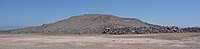
Volcanoes
Several volcanoes existed on the floor of Lake Cahuilla and are now emergent at the southeastern margin of the Salton Sea,
The Salton Buttes are five lava domes that form a 7 kilometres (4.3 mi) long chain; each dome is less than 1 kilometre (0.62 mi) wide.
-
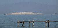
 Obsidian Butte
 -
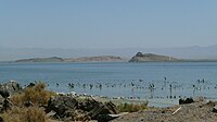
 Mullet Island
 -
 Red Island and Rock Hill


Biology
The lake formed an
The bird species that populated Lake Cahuilla resembled these around the present-day Salton Sea and may have contained species from the Gulf of California as well. They include
Fish species that have been identified as having lived in Lake Cahuilla include
During periods when the level in the lake rose, vegetation in the flooded areas drowned and the organic material coming from it was washed ashore and later buried in coastal sediments.
History
Chronology

The history of Lake Cahuilla spans the late
The latest highstand of Cahuilla was 400–550 years before present.[34] Water levels of 12 metres (39 ft) above sea level occurred between 200 BC and 1580.[25] The well preserved shorelines, lack of desert pavements and desert varnish on shore features, and a relative lack of soil and archeological evidence suggest that Lake Cahuilla reached its maximum in the late Holocene.[137]
It was assumed at first that the lake existed in a single long interval between 1000 and 1500; however, later a succession of wet and dry phases was determined from
Some legends of the Kami and Cahuilla tribes probably refer to Lake Cahuilla[145] and its latest filling.[146] They state that the lake bed tended to be dry but also occasionally flooded; during which times the tribes would have to relocate to the mountains.[147] Evidence for the lake's existence in the historical record, however, is unclear,[41] although it probably still existed at the time where the Spaniards reached the overall region.[37]
The occurrence of a highstand ("Lake A") around 1726 ± CE is secure.
Some anomalously old radiocarbon dates of Lake Cahuilla deposits may be the consequence of the Colorado River transporting ancient carbonates into the lake.[115] In addition, discrepancies between shell and other organic material ages can reach 400–800 years owing to old carbon;[150] shells can also absorb carbon-14 from the air.[151] Other research has documented no substantial old carbon effects.[152]
It is likely that ephemeral lakes formed in the Lake Cahuilla basin during floods of the Colorado River, such as in 1828, 1840, 1849, 1852, 1862, 1867, and 1891.
Research history
In 1853,
Originally it was believed that Lake Cahuilla formed around 900 AD and existed until 1500 but with fluctuations as the Colorado River changed its course.[158] In 1978, Philip J. Wilke proposed that two highstands occurred, one between 900 and 1250 and another between 1300 and 1500.[159] Another proposal by Waters in 1983 suggested highstands 700–900, 940–1210 and after 1250, the latter with some brief recessions to lower lake levels. Both proposals were criticized on the grounds that they came to definite conclusions with insufficient information.[160]
Malcolm J. Rogers suggested that early highstands of Lake Cahuilla had strong effects on the spread of ceramics in the region of California and Baja California, though this is considered untenable today.[57]
Products and significance

The Algodones Dunes, which border old Cahuilla shorelines, were formed by sand blown from Lake Cahuilla.[161][34] This theory was first formulated in 1923.[162] The process occurred either immediately after the lake reached modern highstands,[163] or during earlier higher stands.[22] Most likely, sand was transported to the dune field during times where the lake receded and its bed was exposed to wind.[164] Various stages of Lake Cahuilla may correspond to waves of migrating dunes.[165]
At first the Whitewater River and local
The weight of the water in Lake Cahuilla caused the surface beneath the lake to sink by about 0.4 metres (1 ft 4 in). Such ground depression has been observed at the ancient lakes
The genus
Archaeology
Based on research on findings made there, the lake supported a substantial population that relied mostly on resources from the lake,[182] including aquaculture and fishing.[131] Estimated populations range from 20,000 to 100,000 people.[183] When the lake dried up, the inhabitants switched to other economic activities.[182] Agriculture did not play a major role in food supply.[182]
The Elmore Site, discovered in 1990 during an archeological survey that accompanied work to improve State Route 86,[184] lies close to the southwestern coast of Lake Cahuilla, about 67 metres (220 ft) beneath the highstand level.[185] Archeological features found there include bones (mostly of birds),[186] ceramics,[187] charcoal from fires,[188] pits from wood posts or storage pits,[189] sandstone slabs,[188] and shells of mostly marine origin.[190] This archeological site was active after the waters of Lake Cahuilla had receded from the site,[191] probably for a short time 1660–1680 AD.[192]
It is likely that the repeated fillings and dryings had substantial effects on the communities around the lake. The relatively large size of Lake Cahuilla also meant that widespread "international" communities were affected by the lake. Indeed, evidence indicates that at least three different ethnic groups – Cahuilla,
When Lake Cahuilla filled, it may have encouraged Quechan people to migrate to the area. This migration is considered to be a possible source for the spread of agriculture to the Peninsular Ranges.[195] When Lake Cahuilla dried out after 1500 AD, these people would have migrated back south and west, a move possibly recorded in the oral traditions of the Quechan people and of people they mixed with.[196] Legends have it that lost ships, sometimes described as pirate ships or galleons, sailed Lake Cahuilla and are now buried somewhere in the Colorado Desert.[154]
See also
- Laguna Salada - large seasonal lake near Lake Cahuilla
- Tulare Lake - large seasonal lake in the Central Valley of California
References
- ^ Zelasko, Sandy (1 March 2021). "The Salton Sea Persists: A Photography Destination: In the beginning, a giant sea shimmered in the harsh desert sunlight ..." PSA Journal. 87 (3): 1.
- ^ "Cahuilla". Dictionary.com Unabridged (Online). n.d.
- ^ "Cahuilla". The American Heritage Dictionary of the English Language (5th ed.). HarperCollins.
- ^ a b c d e f Norris & Norris 1961, p. 606.
- ^ Hubbs & Miller 1948, p. 103.
- ISBN 978-0-87919-044-6.
- ^ Aschmann 1959, p. 44.
- ^ a b c d Patten, McCaskie & Unitt 2003, p. 2.
- ^ a b Herbst 2023, p. 5.
- .
- ^ Herbst 2023, p. 4.
- S2CID 33084554.
- ^ a b c Shifflett 2002, p. 2863.
- ^ a b Winspear & Pye 1995, p. 876.
- ISBN 978-0-7844-0499-7.
- .
- ^ a b c d Norris & Norris 1961, p. 607.
- ^ a b c Luttrell et al. 2007, p. 2.
- ^ Morton 1978, p. 3.
- ^ a b c d Waters 1983, p. 373.
- ^ Laylander 1997, p. 46.
- ^ a b c d e Stokes et al. 1997, p. 65.
- ^ Stokes et al. 1997, p. 66.
- ^ a b c d e f Norris & Norris 1961, p. 615.
- ^ a b c d e f g h Buckles, Kashiwase & Krantz 2002, p. 55.
- ^ a b c Waters 1983, p. 374.
- ^ Hill et al. 2023, p. 761.
- ^ .
- ^ Patten, McCaskie & Unitt 2003, p. 3.
- ^ a b Phukan et al. 2019, p. 325.
- ^ Laylander 1997, p. 56.
- ^ Schmitt et al. 2019, p. 7.
- ^ Goldfarb 1983, p. D8.
- ^ S2CID 128959074.
- ^ a b Laylander 1997, p. 47.
- ^ a b c d Philibosian, Fumal & Weldon 2011, p. 35.
- ^ .
- ^ Schmitt et al. 2019, p. 18.
- ^ Winspear & Pye 1995, p. 889.
- ^ Rockwell et al. 2022, p. 15.
- ^ a b c d Laylander 1997, p. 54.
- ^ Gilmore & Castle 1983, p. 474.
- ^ a b Gilmore & Castle 1983, p. 475.
- ^ a b c Winspear & Pye 1995, p. 888.
- ^ Winspear & Pye 1995, p. 887.
- ^ Schmitt et al. 2019, p. 14.
- ^ Waters 1983, p. 382.
- ^ Norris & Norris 1961, p. 608.
- ^ a b c Jefferson & Lindsay 2008, p. 108.
- ^ a b c d e Norris & Norris 1961, p. 614.
- ^ a b c van de Kamp 1973, p. 832.
- ^ Hudnut, Seeber & Rockwell 1989, p. 331.
- ^ a b c Sharp 1981, p. 1758.
- ^ Norris & Norris 1961, p. 616.
- ^ a b Winspear & Pye 1995, p. 878.
- ^ Babcock 1974, p. 331.
- ^ a b c d e Laylander, Don. "The Regional Consequences of Lake Cahuilla". The SOAP: The San Diego State University Occasional Archaeology Papers. Retrieved 2 March 2017.
- ^ Li et al. 2008, p. 186.
- ^ Goldfarb 1983, p. C9.
- ^ Laylander 1997, p. 52.
- ^ a b Babcock 1974, p. 324.
- ^ Laylander 1997, p. 49.
- ^ a b c Derickson et al. 2008, p. 187.
- ^ Luttrell et al. 2007, p. 13.
- ^ Li et al. 2008, p. 193.
- S2CID 129656043.
- ^ Stokes et al. 1997, p. 65,66.
- ^ a b Winspear & Pye 1995, p. 877.
- ^ Jefferson & Lindsay 2008, p. 107.
- ^ Laylander 1997, p. 51.
- ^ Norris & Norris 1961, p. 612.
- ^ a b Li et al. 2008, p. 184.
- ^ a b Norris & Norris 1961, p. 613.
- ^ McCOY, Nokleberg & Norris 1967, p. 1041.
- ^ McCOY, Nokleberg & Norris 1967, p. 1042.
- ^ Li et al. 2008, p. 196.
- .
- ^ a b c d e Brothers et al. 2009, p. 581.
- ^ a b c d e Brothers et al. 2009, p. 582.
- ^ Philibosian, Fumal & Weldon 2011, p. 20.
- ^ Philibosian, Fumal & Weldon 2011, p. 13.
- ^ Brothers et al. 2009, p. 583.
- ^ a b c Patten, McCaskie & Unitt 2003, p. 1.
- ^ Treganza 1945, p. 285.
- ^ a b Meltzner, Rockwell & Owen 2006, p. 2312.
- ^ a b c Robinson, Elders & Muffler 1976, p. 347.
- ^ Sims 1975, p. 146.
- ^ Sims 1975, p. 141.
- ^ Sims 1975, p. 147.
- ^ Philibosian, Fumal & Weldon 2011, p. 31.
- ^ Hill et al. 2023, p. 765.
- ^ Luttrell et al. 2007, p. 12.
- ^ Luttrell et al. 2007, p. 1.
- ^ Philibosian, Fumal & Weldon 2011, p. 36.
- ^ Gilmore & Castle 1983, p. 477.
- ^ Shifflett 2002, p. 2869.
- ^ Babcock 1974, p. 325.
- ^ Sharp 1981, p. 1757,1760.
- ^ Gurrola & Rockwell 1996, p. 5979.
- ^ a b Philibosian, Fumal & Weldon 2011, p. 14.
- S2CID 4432269.
- ^ Hudnut, Seeber & Rockwell 1989, p. 333.
- ^ Hudnut, Seeber & Rockwell 1989, p. 332.
- ^ Philibosian, Fumal & Weldon 2011, p. 33.
- ^ a b Schmitt & Vazquez 2006, p. 262.
- ^ a b Jefferson & Lindsay 2008, p. 109.
- ^ Schmitt & Vazquez 2006, p. 261.
- ^ a b Schmitt et al. 2013, p. 7.
- ^ Robinson, Elders & Muffler 1976, p. 348.
- ^ Robinson, Elders & Muffler 1976, p. 350.
- ^ a b Schmitt et al. 2013, p. 8.
- ^ Schmitt et al. 2013, p. 9.
- ^ Schmitt & Vazquez 2006, p. 263.
- ^ Laylander 1997, p. 69.
- ^ a b Sharp 1981, p. 1757.
- ^ a b c d e Remeika & Sturz 1995, p. 112.
- ^ Remeika & Sturz 1995, p. 114.
- ^ Laylander 1997, p. 37.
- ^ a b Remeika & Sturz 1995, p. 115.
- ^ Hubbs & Miller 1948, p. 106.
- ^ Remeika & Sturz 1995, p. 113.
- ^ a b c d e Patten, McCaskie & Unitt 2003, p. 12.
- ^ Phukan et al. 2019, p. 326.
- ^ Treganza 1945, p. 286.
- ^ Rockwell et al. 2022, p. 8.
- ^ Shifflett 2002, p. 2866.
- ^ a b c Patten, McCaskie & Unitt 2003, p. 13.
- ^ a b c Phukan et al. 2019, p. 327.
- ^ a b Riedel & Costa-Pierce 2001, p. 244.
- ^ a b c Wilke 1980, p. 101.
- ^ a b c Riedel & Costa-Pierce 2001, p. 240.
- ^ a b Gurrola & Rockwell 1996, p. 5981.
- ^ a b c d Wilke 1978, p. 201.
- ^ Morton 1978, p. 22.
- ^ Li et al. 2008, p. 188.
- ^ Babcock 1974, p. 323.
- ^ Waters 1983, p. 377.
- ^ Laylander 1997, p. 68.
- ^ a b c Philibosian, Fumal & Weldon 2011, p. 34.
- ^ Philibosian, Fumal & Weldon 2011, p. 16.
- ^ Gurrola & Rockwell 1996, p. 5982.
- ^ Meltzner, Rockwell & Owen 2006, p. 2318.
- ^ a b Rockwell et al. 2022, p. 3.
- ^ Rockwell et al. 2022, p. 18.
- ^ Wilke 1978, p. 200.
- ^ Rockwell et al. 2022, p. 1.
- ^ Meltzner, Rockwell & Owen 2006, p. 2319.
- ^ Morton 1978, p. 7.
- ^ Meltzner, Rockwell & Owen 2006, p. 2311.
- ^ Philibosian, Fumal & Weldon 2011, p. 27.
- ^ Waters 1983, p. 380.
- ^ Li et al. 2008, p. 187.
- ^ Laylander 1997, p. 61.
- ^ a b "The Salton Sea: California's Overlooked Treasure – Chapter 1". www.sci.sdsu.edu. Retrieved 5 March 2017.
- ^ Buckles, Kashiwase & Krantz 2002, p. 245.
- ^ Li et al. 2008, p. 185.
- ^ Morton 1978, p. 5.
- ^ Treganza 1945, p. 285,286.
- ^ Laylander 1997, p. 63.
- ^ Laylander 1997, p. 64.
- ^ van de Kamp 1973, p. 841.
- ^ Merriam 1969, p. 531,532.
- ^ Norris & Norris 1961, p. 617.
- ^ Stokes et al. 1997, p. 73.
- ^ Derickson et al. 2008, p. 201.
- ^ Merriam 1969, p. 532.
- ^ Merriam 1969, p. 533.
- ^ van de Kamp 1973, p. 830.
- ISBN 978-0-917956-98-0.
- ^ van de Kamp 1973, p. 835.
- JSTOR 211045.
- S2CID 129919492.
- S2CID 131632685.
- OCLC 205915114.
- ^ Shifflett 2002, p. 2861.
- ^ Aschmann 1959, p. 5.
- ^ Buckles, Kashiwase & Krantz 2002, p. 56.
- ^ Laylander 1997, p. 17.
- ^ Waters 1983, p. 385.
- ^ Treganza 1945, p. 289.
- ^ Wilke 1980, p. 102.
- ^ a b c Wilke 1978, p. 202.
- ^ Aschmann 1959, p. 45.
- ^ Laylander 1997, p. 2,3.
- ^ Laylander 1997, p. 1.
- ^ Laylander 1997, p. 40.
- ^ Laylander 1997, p. 32.
- ^ a b Laylander 1997, p. 14.
- ^ Laylander 1997, p. 19.
- ^ Laylander 1997, p. 38.
- ^ Laylander 1997, p. 13.
- ^ Laylander 1997, p. 44.
- ^ Monroe, Kemp & Smith 2013, p. 620.
- ^ Monroe, Kemp & Smith 2013, p. 629.
- S2CID 163726949.
- S2CID 116525201.
Sources
- Aschmann, Homer (1959). "The Evolution of a Wild Landscape and Its Persistence in Southern California". Annals of the Association of American Geographers. 49 (3): 34–56. JSTOR 2561246.
- Babcock, Elkanah A. (1 March 1974). "Geology of the Northeast Margin of the Salton Trough, Salton Sea, California". GSA Bulletin. 85 (3): 321–332. .
- Brothers, D. S.; Driscoll, N. W.; Kent, G. M.; Harding, A. J.; Babcock, J. M.; Baskin, R. L. (August 2009). "Tectonic evolution of the Salton Sea inferred from seismic reflection data". Nature Geoscience. 2 (8): 581–584. doi:10.1038/ngeo590.
- Buckles, Joseph E.; Kashiwase, Kazuyuki; Krantz, Timothy (2002). "Reconstruction of prehistoric Lake Cahuilla in the Salton Sea Basin using GIS and GPS". The Salton Sea. pp. 55–57. ISBN 978-90-481-5989-5.
- Derickson, Dana; Kocurek, Gary; Ewing, Ryan C.; Bristow, Charlie (July 2008). "Origin of a complex and spatially diverse dune-field pattern, Algodones, southeastern California". Geomorphology. 99 (1–4): 186–204. .
- Gilmore, Thomas D.; Castle, Robert O. (1 August 1983). "Tectonic preservation of the divide between the Salton basin and the Gulf of California". Geology. 11 (8): 474–477. .
- Goldfarb, R. J. (1 January 1983). Mineral Resources of the Newberry Mountains and Rodman Mountains Wilderness Study Areas, San Bernardino County, California. U.S. Government Printing Office.
- Gurrola, Larry D.; Rockwell, Thomas K. (10 March 1996). "Timing and slip for prehistoric earthquakes on the Superstition Mountain Fault, Imperial Valley, southern California". Journal of Geophysical Research: Solid Earth. 101 (B3): 5977–5985. .
- Herbst, Matthew (16 June 2023). "Journey to the Center of the World: Memory and the Sacred in the Colorado Desert". World History Connected. 20 (2). ISSN 1931-8642.
- Hill, Ryley G.; Weingarten, Matthew; Rockwell, Thomas K.; Fialko, Yuri (22 June 2023). "Major southern San Andreas earthquakes modulated by lake-filling events". Nature. 618 (7966): 761–766. S2CID 259110409.
- Hubbs, C.L.; Miller, R.R. (1948). "The zoological evidence: Correlation between fish distribution and hydrographic history in the desert basins of western United States". The Great Basin with emphasis on glacial and postglacial times. Vol. 38. University of Utah. pp. 17–166.
{{cite book}}:|journal=ignored (help) - Hudnut, K. W.; Seeber, L.; Rockwell, T. (1 April 1989). "Slip on the Elmore Ranch fault during the past 330 years and its relation to slip on the Superstition Hills fault". Bulletin of the Seismological Society of America. 79 (2): 330–341. .
- Jefferson, George T.; Lindsay, Lowell (2008). "The Lake Cahuilla high shoreline and a stable overflow path elevation, southeastern California and northeastern Baja California". In Reynolds, Robert E. (ed.). Trough to Trough: The Colorado River and the Salton Sea (PDF). California State University, Desert Studies Consortium and LSA Associates. pp. 107–109. OCLC 948512031.
- van de Kamp, P. C. (1 March 1973). "Holocene Continental Sedimentation in the Salton Basin, California: A Reconnaissance". GSA Bulletin. 84 (3): 827–848. .
- Luttrell, Karen; Sandwell, David; Smith-Konter, Bridget; Bills, Bruce; Bock, Yehuda (15 August 2007). "Modulation of the earthquake cycle at the southern San Andreas fault by lake loading". Journal of Geophysical Research. 112 (B8): B08411. .
- Laylander, Don (1997). "The Last Days of Lake Cahuilla: The Elmore Site" (PDF). Pacific Coast Archeological Society Quarterly. 33 (1–2).
- Li, Hong-Chun; Xu, Xiao-Mei; Ku, Teh-Lung; You, Chen-Feng; Buchheim, H. Paul; Peters, Rick (March 2008). "Isotopic and geochemical evidence of palaeoclimate changes in Salton Basin, California, during the past 20 kyr: 1. δ18O and δ13C records in lake tufa deposits". Palaeogeography, Palaeoclimatology, Palaeoecology. 259 (2–3): 182–197. .
- McCOY, Floyd W.; Nokleberg, Warren J.; Norris, Robert M. (1967). "Speculations on the Origin of the Algodones Dunes, California". Geological Society of America Bulletin. 78 (8): 1039. .
- Meltzner, A. J.; Rockwell, T. K.; Owen, L. A. (1 December 2006). "Recent and Long-Term Behavior of the Brawley Fault Zone, Imperial Valley, California: An Escalation in Slip Rate?". Bulletin of the Seismological Society of America. 96 (6): 2304–2328. .
- Merriam, Richard (1969). "Source of Sand Dunes of Southeastern California and Northwestern Sonora, Mexico". Geological Society of America Bulletin. 80 (3): 531. .
- Monroe, Cara; Kemp, Brian M.; Smith, David Glenn (April 2013). "Exploring prehistory in the North American southwest with mitochondrial DNA diversity exhibited by Yumans and Athapaskans: MtDNA Diversity Exhibited by Yumans and Athapaskans". American Journal of Physical Anthropology. 150 (4): 618–631. PMID 23440652.
- Morton, Paul K. (11 May 1978). "Geology and Mineral Resources of Imperial County, California". California Department of Fish and Wildlife.
- Norris, Robert M.; Norris, Kenneth S. (1961). "Algodones Dunes of Southeastern California". Geological Society of America Bulletin. 72 (4): 605. .
- Patten, Michael A.; McCaskie, Guy; Unitt, Philip (19 August 2003). Birds of the Salton Sea: Status, Biogeography, and Ecology. University of California Press. ISBN 978-0-520-23593-9.
- Philibosian, B.; Fumal, T.; Weldon, R. (1 February 2011). "San Andreas Fault Earthquake Chronology and Lake Cahuilla History at Coachella, California". Bulletin of the Seismological Society of America. 101 (1): 13–38. S2CID 129565621.
- Phukan, Anjali; Braje, Todd J.; Rockwell, Thomas K.; Ullah, Isaac (November 2019). "Shorelines in the Desert: Mapping Fish Trap Features along the Southwest Coast of Ancient Lake Cahuilla, California". Advances in Archaeological Practice. 7 (4): 325–336. .
- Remeika, Paul; Sturz, Anne Aleda (1 January 1995). Paleontology and Geology of the Western Salton Trough Detachment, Anza-Borrego Desert State Park, California. San Diego Geological Soc.
- Riedel, Ralf; Costa-Pierce, Barry A. (October 2001). "Review of the Fisheries of the Salton Sea, California, USA: Past, Present, and Future". Reviews in Fisheries Science. 9 (4): 239–270. S2CID 85867382.
- Robinson, Paul T.; Elders, Wilfred A.; Muffler, L.J.P. (1 March 1976). "Quaternary volcanism in the Salton Sea geothermal field, Imperial Valley, California". GSA Bulletin. 87 (3): 347–360. .
- Rockwell, Thomas K.; Meltzner, Aron J.; Haaker, Erik C.; Madugo, Danielle (15 April 2022). "The late Holocene history of Lake Cahuilla: Two thousand years of repeated fillings within the Salton Trough, Imperial Valley, California". Quaternary Science Reviews. 282: 107456. ISSN 0277-3791.
- Sharp, Robert V. (1981). "Variable rates of Late Quaternary strike slip on the San Jacinto Fault Zone, southern California". Journal of Geophysical Research. 86 (B3): 1754–1762. .
- Shifflett, H. (1 October 2002). "New Evidence on the Slip Rate, Renewal Time, and Late Holocene Surface Displacement, Southernmost San Andreas Fault, Mecca Hills, California". Bulletin of the Seismological Society of America. 92 (7): 2861–2877. .
- Schmitt, A. K.; Martin, A.; Stockli, D. F.; Farley, K. A.; Lovera, O. M. (1 January 2013). "(U-Th)/He zircon and archaeological ages for a late prehistoric eruption in the Salton Trough (California, USA)". Geology. 41 (1): 7–10. doi:10.1130/G33634.1.
- Schmitt, Axel K.; Perrine, Andrew R.; Rhodes, Edward J.; Fischer, Christian (2 January 2019). "Age of Obsidian Butte in Imperial County, California, Through Infrared Stimulated Luminescence Dating of Potassium Feldspar from Tuffaceous Sediment" (PDF). California Archaeology. 11 (1): 5–20. S2CID 155512886.
- Schmitt, A. K.; Vazquez, J. A. (15 December 2006). "Alteration and remelting of nascent oceanic crust during continental rupture: Evidence from zircon geochemistry of rhyolites and xenoliths from the Salton Trough, California". Earth and Planetary Science Letters. 252 (3–4): 260–274. hdl:10211.3/171004.
- Sims, John D. (December 1975). "Determining earthquake recurrence intervals from deformational structures in young lacustrine sediments". Tectonophysics. 29 (1–4): 141–152. .
- Stokes, S.; Kocurek, G.; Pye, K.; Winspear, N.R. (February 1997). "New evidence for the timing of aeolian sand supply to the Algodones dunefield and East Mesa area, southeastern California, USA". Palaeogeography, Palaeoclimatology, Palaeoecology. 128 (1–4): 63–75. .
- Treganza, Adan E. (1 January 1945). "The "Ancient Stone Fish Traps" of the Coachella Valley, Southern California". American Antiquity. 10 (3): 285–294. S2CID 164047489.
- Waters, Michael R. (May 1983). "Late Holocene Lacustrine Chronology and Archaeology of Ancient Lake Cahuilla, California". Quaternary Research. 19 (3): 373–387. S2CID 128716530.
- Wilke, Philip J (1978). Late prehistoric human ecology at Lake Cahuilla, Coachella Valley, California. University of California, Dept. of Anthropology. OCLC 930339327.
- Wilke, Philip J. (1980). "Prehistoric weir fishing on recessional shorelines of Lake Cahuilla, Salton Basin, Southeastern California". Proceedings of the Desert Fishes Council: The Eleventh Annual Symposium Held at National Park Service Headquarters, Furnace Creek, Death Valley National Monument, 15–17 November 1979. Desert Fishes Council. pp. 101–103. OCLC 732994148.
- Winspear, N. R.; Pye, K. (December 1995). "Sand supply to the Algodones dunefield, south-eastern California, USA". Sedimentology. 42 (6): 875–891. .
External links
- Cockerell, T. D. A. (22 February 1946). "The Age of Lake Cahuilla". Science. 103 (2669): 235. PMID 17795092.
- Kibbe, Lippincott, Caitlin (7 December 2007). Testing the application and precision of optically stimulated luminescence on dating lacustrine shorelines in the Imperial Valley, Southern California (Thesis).
{{cite thesis}}: CS1 maint: multiple names: authors list (link) - Lang, Anna J. (1981). "William P. Blake's desert of the Colorado River". The California Geographer: 81–94. hdl:10211.2/2459.
- Merrill, M (2014). "Increasing Scales of Social Interaction and the Role of Lake Cahuilla in the Systemic Fragility of the Hohokam System (AD 700–1100)" (PDF). academia.edu.
- Waters, Michael Richard (1980). "Lake Cahuilla: late quaternary lacustrine history of the Salton Trough, California". UA Campus Repository. The University of Arizona.
- Zappia, Natale A. (1 January 2008). The Interior World: Trading and Raiding in Native California, 1700—1863. ISBN 9780549655114.
| Africa | |||||||||||||||||||||||||||||
|---|---|---|---|---|---|---|---|---|---|---|---|---|---|---|---|---|---|---|---|---|---|---|---|---|---|---|---|---|---|
| Antarctica | |||||||||||||||||||||||||||||
| Asia | |||||||||||||||||||||||||||||
| Europe |
| ||||||||||||||||||||||||||||
| North America |
| ||||||||||||||||||||||||||||
| South America |
| ||||||||||||||||||||||||||||
| Summary | |||||||||||||||||||||||||||||