
Lake Tauca
| Lake Tauca | ||
|---|---|---|
| Lake Pocoyu | ||
Primary inflows Glacial meltwater | Desaguadero River, Río Grande de Lipez, Lauca River | |
| Primary outflows | Potentially Pilcomayo River | |
| Basin countries | Bolivia, Chile, Peru | |
| Surface area | 48,000–80,000 km2 (19,000–31,000 sq mi) | |
| Average depth | 100 m (330 ft) | |
| Max. depth | 142 m (466 ft) | |
| Water volume | 1,200–3,810 km3 (290–910 cu mi) | |
| Salinity | 20–90 g/L (0.00072–0.00325 lb/cu in) | |
| Surface elevation | 3,660–3,770 m (12,010–12,370 ft) | |
| Max. temperature | 10 °C (50 °F) | |
| Min. temperature | 2 °C (36 °F) | |
Lake Tauca is a
The duration of Lake Tauca's existence is uncertain. Research in 2011 indicated that the rise in lake levels began 18,500
Lake Tauca is one of several ancient lakes which formed in the Altiplano. Other known lakes are Lake Escara, Ouki, Salinas, Minchin, Inca Huasi and Sajsi, in addition to several water-level rises of Lake Titicaca. The identity of these lakes is controversial; Sajsi is often considered part of Lake Tauca, and the lake is frequently divided into an earlier (Ticaña) and a later (Coipasa) phase.
The formation of Lake Tauca depended on a reduction in air temperature over the Altiplano and an increase in precipitation, which may have been caused by shifts in the Intertropical Convergence Zone (ITCZ) and increased easterly winds. It was originally supposed that glacial melting might have filled Lake Tauca, but the quantity of water would not have been sufficient to fill the whole lake. The lake was accompanied by glacial advance, noticeable at Cerro Azanaques and Tunupa. Elsewhere in South America, water levels and glaciers also expanded during the Lake Tauca phase.
Description


Overview
Lake Tauca existed on the Altiplano, a high plateau with an average altitude of 3,800 to 4,000 metres (12,500 to 13,100 ft),
Lake Tauca was one of many lakes which formed around the world during glacial epochs; others include the
Geography

Larger than Lake Titicaca,
| Surface (1000 km²) |
Surface (1000 sq mi) |
Details | Date of estimate |
|---|---|---|---|
| 43 | 17 | 1981[26] | |
| 80 | 31 | Possibly triggered by a large spillover from Lake Titicaca,[27] 13,000 years ago | 1995[28] |
| 33–60 | 13–23 | 2006[29] | |
| 50 | 19 | 2009[15] | |
| 52 | 20 | At a 3,775 m (12,385 ft) water level | 2011[8] |
| 48 | 19 | Around 12,000 BP, and extending towards the Lípez area | 2012[30] |
| 55 | 21 | 2013[3] | |
| 56.7 | 21.9 | 2013[31] |
| Estimates of lake levels | Date of estimate |
|---|---|
| 3,760 m (12,340 ft) | 2002,[32] 1995[33] |
| 3,770 m (12,370 ft) | 2013[3] |
| 3,780 m (12,400 ft) | 2001,[34] 2006[35] |
| 3,790 m (12,430 ft) | 2013[31] |
| Almost 3,800 m (12,500 ft) | 2005[36] |
Water depths reached 110–120 metres (360–390 ft).
A later phase in lake levels (known as the Ticaña phase) was lower, at 3,657 metres (11,998 ft);[33] the drop from Tauca was abrupt. The late phase of Lake Tauca, Coipasa, had a water level of 3,660 metres (12,010 ft)[44] or 3,700 metres (12,100 ft)[45] and covered an area of about 32,000 square kilometres (12,000 sq mi). Transitions between lake cycles occurred in about one thousand years.[37]
Lake Tauca was the largest lake on the Altiplano during the last 100,000[36]-130,000 years.[46] Although the preceding paleolake (Minchin) was probably shallower,[36][47] there is disagreement about the methods used to ascertain water depth.[48] Some consider Minchin the larger lake;[49] a 1985 paper estimated its size at 63,000 square kilometres (24,000 sq mi), compared with Tauca's 43,000 square kilometres (17,000 sq mi).[50] Confusion may have resulted from the incorrect attribution of Tauca's shorelines to Lake Minchin;[51] a shoreline at 3,760 metres (12,340 ft) formerly attributed to Lake Minchin was dated to the Tauca phase at 13,790 BP.[52] The theory that Tauca is the largest lake follows a deepening trend in the southern Altiplano paleolakes which contrasts with a decreasing trend in the level of Lake Titicaca during the Pleistocene. This pattern probably occurred because the threshold between the two basins progressively eroded, allowing water from Titicaca to flow into the southern Altiplano.[39] The lakes left erosional benches, fan deltas (where the lakes interacted with ice) and lake-sediment deposits,[53] and eroded into moraines.[54] The ridge that separates the Salar de Uyuni and Salar de Coipasa was a peninsula in the lake; San Agustín, San Cristóbal and Colcha formed islands.[55][56]
The lake and its predecessors (such as Lake Minchin) formed in the area currently occupied by salt flats such as the Salar de Uyuni, Salar de Coipasa,
-
 Salar de Ascotan
 -
 Salar de Carcote
 -
 The course of the Lauca River
 -
 Tata Sabaya with the landslide to the left
 -
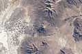
 3D geography of Salar de Uyuni, remainder of Lake Tauca


Hydrology

At a water level of 3,720 metres (12,200 ft), the total volume of the lake has been estimated to be 1,200 cubic kilometres (290 cu mi)[66] to 3,810 cubic kilometres (910 cu mi) at a level of 3,760 metres (12,340 ft).[67] Such volumes could have been reached in centuries.[68] The quantity of water was sufficient to depress the underlying bedrock, which rebounded after the lake disappeared; this has resulted in altitude differences of 10 to 20 metres (33 to 66 ft).[41] Based on oxygen-18 data in lake carbonates, water temperatures ranged from 2 to 10 °C (36 to 50 °F)[69] or 7.5 ± 2.5 °C (45.5 ± 4.5 °F).[70] Tauca may have been subject to geothermal heating.[71]
The lake was deep and saline,
| Salt concentration | Comment | Source |
|---|---|---|
| 20 g/L (0.00072 lb/cu in) | [40] | |
| 30 to 40 g/L (0.0011 to 0.0014 lb/cu in) | The latter, earlier, estimate may be incorrect; many salinity values were obtained from deposits at the lake margins, which tend to be less saline[74] | [75] |
| 60 to 90 g/L (0.0022 to 0.0033 lb/cu in) | Later research | [76] |
Estimated salt concentrations (based on a lake level of 3,720 metres (12,200 ft), for sodium chloride, lithium and bromine):
| Mineral | Concentration | Source |
|---|---|---|
| Sodium chloride | 73 g/L (0.0026 lb/cu in) | [77] |
| Chlorine | 54 g/L (0.0020 lb/cu in) | [78] |
| Sodium | 32 g/L (0.0012 lb/cu in) | [78] |
| Sulfate | 8.5 g/L (0.00031 lb/cu in) | [78] |
| Magnesium | 3 g/L (0.00011 lb/cu in) | [78] |
| Potassium | 2.2 g/L (7.9×10⁻⁵ lb/cu in) | [78] |
| Calcium | 1 g/L (3.6×10⁻⁵ lb/cu in) | [78] |
| Boron | 60 mg/L (2.2×10⁻⁶ lb/cu in) | [78] |
| Lithium | 10 mg/L (3.6×10⁻⁷ lb/cu in) or 80 mg/L (2.9×10⁻⁶ lb/cu in) | [77] and [79] |
| Bromine | 1.6 ± 0.4 mg/L (5.8×10⁻⁸ ± 1.4×10⁻⁸ lb/cu in) | [79] |
Some of this salt penetrated aquifers beneath the lake, which still exist.[80] A significant excess NaCl concentration has been inferred for Lake Tauca, possibly stemming from salt domes whose contents moved from lake to lake.[81] Precipitation of calcium carbonate resulted in lake waters becoming progressively enriched in more soluble salts.[82]
Glacial
Although earlier theories postulated that large lakes formed from glacial meltwater, increased precipitation or decreased evaporation (or both) are today considered necessary for lake formation;
Based on a 60,000-square-kilometre (23,000 sq mi) surface area, the evaporation rate has been estimated at over 70,000,000,000 cubic metres per year (2.5×10¹² cu ft/a)—comparable to the discharges of the Nile or Rhine.[102] Less than half of this evaporation returned to the lake as precipitation;[103] in the central sector of the lake[104] at Tunupa, this would have increased precipitation by 80%,[90] delaying the retreat of glaciers in the area.[105] Groundwater from Lake Tauca may have drained into the Quebrada Puripica, northeast of Laguna Miscanti.[106] Given the height of the sill between the two basins and evidence found at Poopó,[102] water may have drained from the Coipasa-Uyuni basin into Lake Poopó during the Coipasa cycle.[107]
Glacial debris and ice were probably present at the lake,[36] with fan deltas at Tunupa overlapping the Lake Tauca shore.[108] At Tunupa and Cerro Azanaques, glaciers reached their maximum size shortly before the lake level peaked and probably contributed to water levels when their retreat began.[109] Two minor glacial advances, over 12,000 BP and about 11,000 BP, appear to coincide with Lake Tauca.[110]
Lake Tauca left up to 5 metres (16 ft) thick sediments in the southern Altiplano,[111] and tufa deposits formed in the lake. The continental environment Pleistocene sediments were formed from lacustrine carbonate deposits. These rocks contain amphibole, clay minerals such as illite, kaolinite and smectite, feldspar, plagioclase, potassium feldspar, pyroxene and quartz. The composition of these rocks resembles that of the Altiplano soils.[112] The sedimentation rate in the Uyuni basin was about 1 millimetre per year (0.0012 in/Ms).[113]
Biology

Low concentrations of pollen are found in sediments left by Lake Tauca in the Salar de Uyuni.[114] Lake Minchin sediments contain more pollen (indicating that it may have had a more favourable climate),[115] but the lack of pollen may be the product of a deeper lake.[116] Polylepis may have thrived in favourable salinity and climatic conditions.[36] Increased Polylepis and Acaena pollen is observed towards the end of the Tauca episode.[117]
The lake was deep enough for the development of planktonic diatoms,
Sediments at the shoreline contain fossils of
Research history
Reports of lake deposits on the Altiplano go back to 1861.
Predecessor lakes
Before Lake Tauca, there were Ouki (120,000–98,000 years ago), Salinas (95,000–80,000 years ago), Inca Huasi (about 46,000 years ago), Sajsi (24,000–20,500 years ago) and Coipasa (13,000–11,000 years ago).[132] Inca Huasi and Minchin are sometimes considered the same lake phase,[133] and other researchers have suggested that Lake Minchin is a combination of several phases.[134][135] The Ouki cycle may be subdivided in the future, and a number of sometimes-contradictory names and dates exist for these paleolakes.[107]
Preceding lake: Escara
Escara was identified in the central Altiplano,[130] it may be the oldest Altiplano lake cycle.[136] Lake levels reached an altitude of 3,780 metres (12,400 ft);[137] perhaps reaching the size of Lake Tauca and Ouki.[138] At the town of Escara, 8 metres (26 ft) thick deposits have been left by the lake.[139]
Escara is dated to 191,000 years
Hypothetical pluvial and lake: Minchin
A humid period 46,000-36,000 years ago has been deemed "Lake Minchin"; it led to the formation of a large body of water on the Altiplano
The name "Lake Minchin" has been used inconsistently to refer to either the palaeolake at Lake Poopo,
Chronology

The existence of Lake Tauca was preceded by a dry period, with minor lake events recorded in Salar de Uyuni in the Late Pleistocene at 28,200–30,800 and 31,800–33,400 BP.[145] This period was accompanied by the disappearance of ice from Nevado Sajama.[86] A dry period is also noted in Africa and other parts of South America around 18,000 BP, and the retreat of the Amazon rainforest may have produced the lake low-water mark.[162] The era may have been drier than the present.[163] The drying of Lake Minchin left a salt layer about 20 metres (66 ft) thick in the Salar de Uyuni, where gullies formed.[164] Some ooid sediments formed before the Lake Tauca phase.[165] Around 28,000 BP, lake levels rose in Lake Huinaymarca (Lake Titicaca's southern basin), preceding Lake Tauca by about two millennia.[166] During this period, lakes in the Uyuni basin were intermittent.[167] Previous lakes in the basin were generally small and shallow.[21]
The radiometric age of Lake Tauca ranges from 72,600 to 7200 BP.[168] The duration of the lake highstands may be overestimated due to radiation scatter.[169] Radiocarbon dates have been obtained on crusts containing calcite, gastropod shells, stromatolites and structures left behind by algae.[170] The Lake Tauca shorelines formed over more than century-long periods.[98]
The first research, by Servant and Fontes in 1978, indicated a lake age between 12,500 and 11,000 BP according to
In 1993 it was suggested that Lake Tauca had an earlier phase, with water levels reaching 3,740 metres (12,270 ft), and a later phase reaching 3,720 metres (12,200 ft).[173] Research published in 1995 indicated that the lake was shallow for over a millennium before rising to (and stabilizing at) its maximum level. Water levels between 13,900 and 11,500 BP reached 3,720 metres (12,200 ft); 3,740 metres (12,270 ft) was reached between 12,475 and 11,540 BP, and 3,760 to 3,770 metres (12,340 to 12,370 ft) between 12,200 and 11,500 BP.[175]
Research in 1999 indicated an earlier start of the Tauca lake cycle, which was subdivided into three phases and several sub-phases. Around 15,438 ± 80 BP (the Tauca Ia phase), water levels in Salar de Uyuni were 4 metres (13 ft) higher than the current salt crust. Lake levels then rose to 27 metres (89 ft) above the salt flat, accompanied by freshwater input (Tauca Ib). Around 13,530 ± 50 BP (Tauca II), the lake reached an altitude of 3,693 metres (12,116 ft), [118] not exceeding 3,700 metres (12,100 ft).[176] At this time, strong gully erosion and alluvial fans probably formed in Bolivian valleys.[177] Between 13,000 and 12,000 BP, the lake reached its greatest depth—110 metres (360 ft)—of the Tauca III period. Dates of 15,070 BP and 15,330 BP were obtained for the highest shoreline, at 3,760 metres (12,340 ft).[176] After 12,000 BP, water levels decreased abruptly by 100 metres (330 ft).[178] An even-earlier start was proposed by 2001 research, based on sediments in the Uyuni basin, which determined that Lake Tauca began developing 26,100 BP.[145] A 2001 review indicated that most radiometric dates for Lake Tauca cluster between 16,000 and 12,000 BP, with lake levels peaking around 16,000 BP.[35] A drop in oxygen-18 concentration in the Nevado Sajama glaciers has been associated with increased precipitation around 14,300 years ago.[68] A 2005 book estimated the duration of the Lake Tauca phase at between 15,000 and 10,500 BP.[179]
Research in 2006 postulated that the Lake Tauca
A 2011 lake history study set the beginning of the lake-level rise at 18,500 years ago. Levels rose slowly to 3,670 metres (12,040 ft) 17,500 years ago, before accelerating to 3,760 metres (12,340 ft) by 16,000 years ago. Contradictions between lake depths determined by shorelines and diatom-fossil analysis led to two lake-level-rise chronologies: one reaching 3,700 metres (12,100 ft) 17,000 years ago and the other reaching 3,690 metres (12,110 ft) between 17,500 and 15,000 years ago. The lake level would have peaked from 16,000 to 14,500 years ago at 3,765 to 3,775 metres (12,352 to 12,385 ft) altitude. Shortly before 14,200 BP, the lake level would have begun its drop to 3,660 metres (12,010 ft) by 13,800 BP.[182] The Coipasa phase began before 13,300 BP and reached its peak at 3,700 metres (12,100 ft) 12,500 years ago. The Coipasa lake's regression was nearly complete around 11,500 years ago.[70] A 2013 reconstruction envisaged a lake level rise between 18,000 - 16,500 years ago, followed by a highstand between 16,500 - 15,500 and a decrease in lake levels between 14,500 - 13,500 years ago.[183]
Lake Tauca is sometimes subdivided into three phases (Lake Tauca proper, Ticaña and Coipasa), with the Tauca phase lasting from 19,100 to 15,600 BP.
The Ticaña phase was accompanied by a 100-metre (330 ft) drop in water level.[33] The Tauca and Coipasa phases are sometimes considered separate.[35] Lakes Tauca and Minchin have been considered the same lake system and called Lake Pocoyu, after the present-day lakes in the area.[190] "Minchin" is also used by some authors as a name for the system.[126]

The Chita
A pattern of lake cycles becoming longer than the preceding one has been noted.[39] Water from the lake may have contributed to increased oxygen-18 at Sajama around 14,300 years ago, possibly triggered by evaporation.[197] As the lake level dropped, Lake Poopó would have been disconnected first; the sill separating it from the rest of Lake Tauca is relatively shallow. Coipasa and Uyuni would have remained connected until later.[76] Water levels in Lake Titicaca's Lake Huinaimarca were low by 14,200 BP.[167] By the Antarctic Cold Reversal, Lake Tauca was dry.[198]
The end of the Tauca phase was followed by dry and cold conditions in the Puna, similar to the Younger Dryas, then by an early-Holocene humid period associated with decreased solar radiation. After 10,000 BP, another drought lasted from 8,500 BP to 3,600 BP,[186] and peaked from 7,200–6,700 BP.[199] The world's largest salt pan was left behind when Lake Tauca dried up,[30] with approximately 10 metres (33 ft) of material left at Salar de Uyuni.[200] Lake basins in the Altiplano which had filled during the Tauca phase were separated by lower lake levels.[201] Channels between the lakes testify to their former connections.[37]
Climate

There are few reconstructions of how the climate looked before and after the Lake Tauca highstand.[37] It has been estimated that summer precipitation would have increased by 315 ± 45 millimetres (12.4 ± 1.8 in) and temperature dropped 3 °C (5.4 °F) for Lake Tauca to form.[202] According to a 1985 estimate, increased precipitation of 200 millimetres per year (7.9 in/year) would be needed;[203] the estimate was subsequently revised to 300 millimetres per year (12 in/year).[51] With a 5 to 7 °C (9.0 to 12.6 °F) temperature decrease, a 20–75% increase in precipitation would be required to form the lake.[204] Research in 2013 indicated that the climate at the Tunupa volcano (in the centre of Lake Tauca) was about 6 to 7 °C (11 to 13 °F) colder than present, with rainfall estimated at 320 to 600 millimetres (13 to 24 in).[205] A 2018 estimate supported by 2020 research[206] envisages a temperature decrease of 2.9 ± 0.2 °C (5.22 ± 0.36 °F) and a mean precipitation 130% higher than today, about 900 ± 200 millimetres per year (35.4 ± 7.9 in/year);[207] this precipitation increase was concentrated on the eastern side of the catchment of Lake Tauca while the southernmost watershed was almost as dry as present-day.[104] In a coupled glacier-lake model, temperatures were conditionally estimated at 5.7 ± 1.1 °C (10.3 ± 2.0 °F) lower than today.[208] In the southern Altiplano, precipitation exceeded 500 millimetres (20 in) during this epoch.[209] In the central Altiplano, precipitation was 1.5 to three times higher than today.[210] In and around the Arid Diagonal, precipitation doubled from 300 millimetres per year (12 in/year) to 600 millimetres per year (24 in/year).[211] Around the lakes precipitation may have increased nine-fold.[212]
The formation of Lake Tauca coincides with Heinrich event 1[46] and has been explained with a southward shift of the Bolivian high[a] that increased transport of easterly moisture into the Altiplano[214] and a strengthening of the South American Summer Monsoon due to a decrease in the cross-equatorial transport of heat.[215] Earlier highstands of Altiplano lakes may also correlate to earlier Heinrich events.[25] Increased cloud cover probably increased the effective precipitation by reducing evaporation rates.[109] In contrast, insolation rates do not appear to be linked to lake-level highstands in the Altiplano;[216] the lake expansion occurred when summer insolation was low[186] although recently an insolation maximum between 26,000 and 15,000 years ago has been correlated to the Tauca stage.[217] The humidity above the lake has been estimated at 60%, taking into account the oxygen-18 content of carbonates deposited by the lake.[69]
Coinciding with Lake Tauca, between 17,000 and 11,000 BP glaciers expanded in the Andes between 18° and 24° south latitude.
Context
The formation and disappearance of Lake Tauca was a major hydrological event
Increased precipitation during the Tauca phase was probably triggered by the southern movement of the
Another theory posits that vegetation changes and lake development would have decreased the
Related events

During the Tauca phase, Lake Titicaca grew in size; the pampas around Titicaca were left by that lake and the paleolake Minchin.[258] Lake Titicaca rose by about 5 metres (16 ft),[137] reaching a height of 3,815 metres (12,516 ft),[130] and its water became less saline.[72] Another shoreline, at 3,825 metres (12,549 ft) altitude, has been linked to a highstand of Lake Titicaca during the Tauca epoch.[259] The highstand, in 13,180 ± 130 BP, is contemporaneous with the Tauca III phase. Titicaca's water level then dropped during the Ticaña phase and probably rose again during the Coipasa.[185] The highstands left terraces at the southern and eastern shores of Lake Titicaca[c],[260] which were later deformed by tectonic processes.[261]
Lake Titicaca probably overflowed on the south between 26,000 and 15,000 BP,[195] adding water to Lake Tauca.[262][263] Titicaca's outflow, the Rio Desaguadero, may have been eight times that of today.[83] Lake Titicaca was thought to have had a low water level during the Tauca phase before evidence of deeper water was found.[264] Higher lake levels have been found at the same time in other parts of the Altiplano and areas of the Atacama above 3,500 metres (11,500 ft).[265] This was not the first time Lake Titicaca rose; Pleistocene lake-level rises are known as Mataro, Cabana, Ballivian and Minchin.[266] The overflow from Lake Titicaca into the southern Altiplano was possible for the last 50,000 years; this might explain why there is little evidence of large lakes in the southern Altiplano in the time before 50,000 years ago.[263]
Lakes also formed (or expanded) in the Atacama at that time;
During the Tauca phase, water levels in Laguna Miscanti were higher than today;
Downward expansion of vegetation and increased discharge in the rivers draining to the Pacific Ocean has been correlated to the Tauca period.
Glaciers advanced in the
Landslide activity decreased in northwestern Argentina
Environmental consequences

Some fossil water reserves in the dry Andes formed during the Tauca phase,[328] the groundwater in the northern Chilean Central Valley,[329] around Peinado in the Puna[330] and part of the groundwater under Pampa del Tamarugal for example date back to the Lake Tauca wet phase.[331] Lake Tauca may have supplied water to the Rio de la Plata region, sustaining life there during dry periods.[91]
The Lake Tauca and preceding cycles left evaporite deposits,[332] with sediment layers left by the lake in the Salar de Uyuni reaching a thickness of 6 metres (20 ft).[131] The salts are continually washed out and re-deposited by ephemeral rainfall, causing the salt surfaces of the Salars to become very flat and smooth.[82] The high aerosol content of the air in the Uyuni region has been attributed to fine sediments left by Lake Tauca.[22] Diatomaceous deposits containing clay or calc were left behind by the lake,[42] and ulexite deposits were formed by sediments in its deltas.[333]
The taxonomic similarity between fish species of the genus
Altiplanos and paleolakes in Latin America
| Latin America | Valley of Mexico | Altiplano Cundiboyacense | Altiplano Boliviano |
|---|---|---|---|
.svg) M
C
B
|
 |
 |
|
| Paleolake | Lake Texcoco | Lake Humboldt | Lake Tauca |
| Human occupation (yr BP) | 11,100 - Tocuila | 12,460 - El Abra | 3530 - Tiwanaku |
| Pre-Columbian civilisation | Aztec | Muisca | Inca |
| Today | |||
| Elevation | 2,236 m (7,336 ft) | 2,580 m (8,460 ft) | 3,800 m (12,500 ft) |
| Area | 9,738 km2 (3,760 sq mi) | 25,000 km2 (9,700 sq mi) | 175,773 km2 (67,866 sq mi) |
| References |
See also
- Uturunku
Notes
- ^ The Bolivian high is an anticyclone which steers moist air onto the Altiplano.[213]
- ^ The South Atlantic Convergence Zone is a rainfall belt over central and southern Brazil during southern hemisphere summer.[250]
- ^ The name "Lake Minchin" is often used for the largest lake on the Altiplano,[34] however the highstand at the end of the Pleistocene is called Tauca.[52]
- ^ a b c d e f g h i j k The associated Central Andean Pluvial Event coincided with the formation of Lake Tauca[234]
- ^ Including sites of Cerro Kaskio[322] and Cueva Bautista close by,[323]
- ^ Area Altiplano Cundiboyacense approximately 25,000 square kilometres (9,700 sq mi)
References
- .
- ^ S2CID 85269358.
- ^ a b c d e Blard et al. 2013, p. 261.
- ^ a b c Rouchy et al. 1996, p. 974.
- ^ a b Zech et al. 2008, p. 639.
- ^ a b Chepstow-Lusty et al. 2005, p. 91.
- ^ Argollo & Mourguiart 2000, p. 38.
- ^ a b c d e Blard et al. 2011, p. 3974.
- ^ a b Servant & Fontes 1978, p. 10.
- ^ Ballivian & Risacher 1981, p. 17.
- ISBN 978-3-642-13944-4.
- ^ Clayton & Clapperton 1997, p. 169.
- ^ Risacher & Fritz 1991, p. 211.
- ^ Placzek et al. 2009, p. 25.
- ^ ISBN 978-1-4020-4411-3.
- ^ Risacher & Fritz 1991, p. 212.
- ^ Clayton & Clapperton 1997, p. 170.
- ^ Blodgett, Isacks & Lenters 1997, p. 20.
- ^ Blodgett, Isacks & Lenters 1997, p. 21.
- ^ a b Blodgett, Isacks & Lenters 1997, p. 23.
- ^ a b Broecker & Putnam 2012, p. 20.
- ^ ISBN 978-3-540-32355-6.
- ^ Nunnery et al. 2019, p. 883.
- ^ a b c Heine 2019, p. 253.
- ^ S2CID 240919206.
- ^ a b c Ballivian & Risacher 1981, p. 33.
- ^ Sylvestre et al. 1995, p. 296.
- ^ a b c d Sylvestre et al. 1995, p. 293.
- ^ a b Placzek, Quade & Patchett 2006, p. 516.
- ^ S2CID 85126005.
- ^ a b c Placzek, Quade & Patchett 2013, p. 103.
- S2CID 129547417.
- ^ a b c Sylvestre et al. 1995, p. 286.
- ^ a b c d Placzek, Quade & Patchett 2006, p. 517.
- ^ a b c Fornari, Risacher & Féraud 2001, p. 271.
- ^ a b c d e f g h i Chepstow-Lusty et al. 2005, p. 96.
- ^ a b c d Martin et al. 2020, p. 2.
- ^ S2CID 45518308.
- ^ a b c Fornari, Risacher & Féraud 2001, p. 280.
- ^ a b Dassargues 2000, p. 412.
- ^ a b Clayton & Clapperton 1997, p. 174.
- ^ a b c Servant & Fontes 1978, p. 16.
- ^ Placzek, Quade & Patchett 2013, p. 99.
- ^ Sylvestre et al. 1995, p. 292.
- ^ a b Placzek, Quade & Patchett 2011, p. 242.
- ^ a b c Martin et al. 2018, p. 1.
- ^ Rouchy et al. 1996, p. 990.
- ^ a b McPhillips et al. 2013, p. 2492.
- .
- ^ Hastenrath & Kutzbach 1985, p. 250.
- ^ a b c Clayton & Clapperton 1997, p. 180.
- ^ a b Blodgett, Isacks & Lenters 1997, p. 2.
- ^ Clayton & Clapperton 1997, p. 171.
- ^ Schäbitz & Liebricht 1999, p. 123.
- ^ a b c Arellano 1984, p. 87.
- ^ Ahlfeld 1956, p. 130.
- S2CID 89236061.
- ^ Ericksen, Vine & Raul Ballón 1978, p. 355.
- ^ .
- ^ Arellano 1984, p. 90.
- ^ S2CID 12989178.
- S2CID 203137981.
- S2CID 233526238.
- S2CID 251479393.
- S2CID 128824938.
- ^ Risacher & Fritz 2000, p. 382.
- ^ Blodgett, Isacks & Lenters 1997, p. 11.
- ^ ISBN 978-90-481-2672-9.
- ^ a b c Placzek, Quade & Patchett 2011, p. 240.
- ^ a b Blard et al. 2011, p. 3986.
- ^ Blard et al. 2011, p. 3975.
- ^ a b Sylvestre et al. 1995, p. 282.
- ^ a b Nunnery et al. 2019, p. 889.
- ^ Risacher & Fritz 1991, p. 223.
- ^ a b c Servant & Fontes 1978, p. 20.
- ^ a b Risacher & Fritz 1991, p. 224.
- ^ a b Risacher & Fritz 2000, p. 381.
- ^ a b c d e f g Ballivian & Risacher 1981, p. 132.
- ^ a b Risacher & Fritz 2000, p. 378.
- ^ Coudrain-Ribstein, Anne; Olive, Philippe; Quintanilla, Jorge; Sondag, Francis; Cahuaya, David (1995). "Salinity and isotopic dynamics of the groundwater resources on the Bolivian Altiplano" (PDF). Application of Tracers in Arid Zone Hydrology: 270. Archived (PDF) from the original on 22 November 2006. Retrieved 25 September 2016.
- ^ Risacher & Fritz 2000, p. 374.
- ^ a b c Ericksen, Vine & Raul Ballón 1978, p. 356.
- ^ a b Grove et al. 2003, p. 294.
- ^ Cross et al. 2001, p. 7.
- ^ Coudrain et al. 2002, p. 303.
- ^ a b Baker et al. 2001, p. 700.
- ^ Placzek, Quade & Patchett 2011, p. 239.
- .
- .
- ^ a b Blard et al. 2009, p. 3421.
- ^ a b Sánchez-Saldías & Fariña 2014, p. 258.
- ^ Sánchez-Saldías & Fariña 2014, p. 257.
- ^ Ahlfeld 1956, p. 132.
- ISSN 2545-6377.
- ^ a b Seltzer 1990, p. 147.
- ^ Seltzer 1990, p. 149.
- ^ Grove et al. 2003, p. 282.
- ^ a b Hastenrath & Kutzbach 1985, p. 254.
- ^ Blodgett, Isacks & Lenters 1997, p. 12.
- ^ Grove et al. 2003, p. 290.
- ^ Placzek, Quade & Patchett 2011, p. 243.
- ^ a b Placzek, Quade & Patchett 2011, p. 241.
- ^ Blard et al. 2011, p. 3987.
- ^ a b Martin et al. 2018, p. 4.
- ^ Palacios et al. 2020, p. 16.
- S2CID 128555380.
- ^ a b Placzek, Quade & Patchett 2011, p. 233.
- ^ Blard et al. 2009, p. 3417.
- ^ a b Clayton & Clapperton 1997, p. 181.
- ^ a b Hastenrath & Kutzbach 1985, p. 255.
- ^ Schäbitz & Liebricht 1999, pp. 115–116.
- ^ Placzek et al. 2006, p. 11.
- ^ S2CID 213568450.
- ^ Chepstow-Lusty et al. 2005, p. 93.
- ^ Chepstow-Lusty et al. 2005, p. 95.
- ^ a b Chepstow-Lusty et al. 2005, p. 97.
- ^ Gosling et al. 2008, p. 48.
- ^ a b Sylvestre et al. 1999, p. 59.
- ^ a b c Rouchy et al. 1996, p. 987.
- ^ a b c Blard et al. 2011, p. 3976.
- ^ Placzek, Quade & Patchett 2006, p. 519.
- ^ a b Rouchy et al. 1996, p. 989.
- ^ Rouchy et al. 1996, p. 978.
- ^ Moon 1939, p. 30.
- ^ Moon 1939, p. 31.
- ^ a b c Sánchez-Saldías & Fariña 2014, p. 250.
- ^ Moon 1939, p. 32.
- .
- ^ Bowman 1914, p. 178.
- ^ a b c d Fornari, Risacher & Féraud 2001, p. 270.
- ^ a b c Fornari, Risacher & Féraud 2001, p. 279.
- ^ Placzek, Quade & Patchett 2006, p. 520.
- ^ a b c d McPhillips et al. 2013, p. 2490.
- ^ a b Placzek, Quade & Patchett 2006, p. 528.
- ^ Nunnery et al. 2019, p. 882.
- ^ Placzek et al. 2009, p. 34.
- ^ a b c Dejoux & Iltis 1992, p. 9.
- ^ a b c Placzek et al. 2009, p. 32.
- ^ Placzek et al. 2009, p. 30.
- S2CID 84024906.
- ^ Placzek et al. 2009, p. 27.
- ^ S2CID 231767839.
- ^ Ahlfeld, Federico (1972). Geología de Bolivia (in Spanish). Editorial Los Amigos del Libro. p. 158.
- ^ Heine 2019, p. 223.
- ^ a b c Baker et al. 2001, p. 699.
- ^ S2CID 133734484 – via ResearchGate.
- .
- ^ a b Servant-Vildary & Mello e Sousa 1993, p. 71.
- ^ a b Huber, Bugmann & Reasoner 2005, p. 96.
- .
- S2CID 134540130.
- S2CID 67779046.
- ^ S2CID 214164504.
- ^ S2CID 134780354.
- ^ Clapperton, C.M. (1991). "Glacier fluctuations of the last glacial-interglacial cycle in the Andes of South America". Bamberger Geograpische Schriften. 11: 196.
- ^ a b Clapperton et al. 1997, p. 58.
- ^ Seltzer 1990, p. 142.
- ^ Heine 2019, p. 270.
- S2CID 129226182.
- ^ Orellana et al. 2023, p. 17.
- .
- ^ Servant & Fontes 1978, pp. 20–21.
- ^ Messerli, Grosjean & Vuille 1997, p. 231.
- ^ Servant & Fontes 1978, p. 15.
- ^ Rouchy et al. 1996, p. 983.
- ^ Gosling et al. 2008, p. 46.
- ^ a b Gosling et al. 2008, p. 47.
- ^ Fornari, Risacher & Féraud 2001, p. 272.
- ^ Broecker & Putnam 2012, p. 19.
- ^ Sylvestre et al. 1999, p. 54.
- ^ Servant & Fontes 1978, p. 19.
- ^ Servant & Fontes 1978, p. 17.
- ^ a b Servant-Vildary & Mello e Sousa 1993, p. 70.
- ^ a b Rouchy et al. 1996, p. 975.
- ^ Clayton & Clapperton 1997, p. 175.
- ^ a b Sylvestre et al. 1999, p. 60.
- ^ Sylvestre et al. 1999, p. 63.
- ^ Sylvestre et al. 1995, p. 294.
- ISBN 978-2-7099-1575-5.
- ^ a b Placzek, Quade & Patchett 2006, pp. 524–525.
- ^ a b Placzek, Quade & Patchett 2006, p. 527.
- ^ a b Blard et al. 2011, p. 3984.
- ^ Martin et al. 2020, pp. 2–3.
- ^ a b Martin et al. 2020, p. 3.
- ^ a b c Sylvestre et al. 1999, p. 62.
- ^ a b c Kull & Grosjean 1998, p. 871.
- hdl:2445/99385.
- .
- ^ a b c d Frechen et al. 2018, p. 16.
- ^ Argollo & Mourguiart 2000, p. 40.
- ^ Placzek et al. 2009, p. 33.
- ^ a b Blard et al. 2013, p. 272.
- ^ a b c Workman et al. 2020, p. 16.
- .
- ^ S2CID 112618.
- S2CID 86021680.
- ^ Quesada et al. 2015, p. 94.
- ^ Palacios et al. 2020, p. 33.
- .
- ^ Rouchy et al. 1996, p. 976.
- JSTOR 3673632. Retrieved 27 September 2016.
- .
- ^ Hastenrath & Kutzbach 1985, p. 253.
- ^ Rigsby et al. 2005, p. 672.
- ^ Blard et al. 2009, p. 3422.
- ^ Martin et al. 2020, p. 23.
- ^ Martin et al. 2018, p. 3.
- ^ Placzek, Quade & Patchett 2013, p. 104.
- S2CID 129052389.
- ^ .
- ^ a b Palacios et al. 2020, p. 27.
- ^ Palacios et al. 2020, p. 29.
- ^ Martin et al. 2020, p. 24.
- ^ Martin et al. 2018, pp. 5–6.
- ^ a b Cuña-Rodríguez et al. 2020, p. 10.
- ^ Placzek, Quade & Patchett 2006, p. 530.
- ^ a b D'Arcy et al. 2019, p. 39.
- ^ S2CID 140586233.
- S2CID 128502460.
- .
- S2CID 129593047.
- ^ Gardeweg, Moyra Cristina; Delcorto, Luis; Selles, Daniel (December 2018). Depósitos glaciares de la alta cordillera de Iquique - Región de Tarapacá, Chile (PDF). 15th Chilean Geological Congress (in Spanish). p. 672. Retrieved 13 November 2022.
- ^ Servant & Fontes 1978, p. 22.
- ^ Smith, Lowell & Caffee 2009, p. 367.
- ^ Vizy & Cook 2007, p. 5.
- S2CID 129861307.
- .
- ^ Quesada et al. 2015, p. 103.
- ^ Martin et al. 2020, p. 25.
- ^ Seltzer 1990, p. 150.
- ^ S2CID 252384172.
- ^ Latorre et al. 2019, pp. 72–73.
- ^ Latorre et al. 2019, p. 73.
- ^ ISSN 1029-2004. Retrieved 1 September 2016.
- S2CID 73431668.
- ^ a b Gutiérrez et al. 2018, p. 2.
- ^ a b Souza et al. 2021, p. 2.
- S2CID 140202754.
- .
- ISSN 0277-3791.
- ^ Workman et al. 2020, p. 15.
- ^ S2CID 129771332.
- .
- ^ a b D'Arcy et al. 2019, p. 40.
- .
- ^ Grove et al. 2003, p. 292.
- .
- ^ Heine 2019, p. 216.
- .
- ^ Wong et al. 2021, p. 1.
- ^ Wong et al. 2021, p. 6.
- ^ Wong et al. 2021, p. 7.
- ^ Kull & Grosjean 1998, p. 872.
- ^ Kull & Grosjean 1998, p. 878.
- .
- ^ Placzek, Quade & Patchett 2006, p. 531.
- ^ Orellana et al. 2023, p. 18.
- ISBN 978-0-521-81635-9.
- ^ Blodgett, Isacks & Lenters 1997, p. 3.
- S2CID 211832412.
- .
- ^ Vizy & Cook 2007, p. 1.
- ^ a b Heine 2019, p. 217.
- S2CID 32856578.
- .
- ISBN 978-0-521-03168-4.
- .
- ^ Blodgett, Isacks & Lenters 1997, p. 4.
- ^ Quezada, Andrés; Varas, Laura; Vásquez, Paulina; Sepúlveda, Fernando; Cifuentes, José Luis (December 2018). Evidencias de un paleolago durante el Pleistoceno Tardío en el salar de Llamara, Desierto de Atacama, Región de Tarapacá, Chile (PDF). 15th Chilean Geological Congress (in Spanish). p. 1342. Retrieved 13 November 2022.
- .
- ^ Messerli, Grosjean & Vuille 1997, p. 232.
- . Retrieved 1 September 2016.
- ^ McPhillips et al. 2013, p. 2497.
- S2CID 58905345.
- .
- S2CID 133749937.
- from the original on 2 December 2016. Retrieved 1 September 2016.
- S2CID 202876663.
- hdl:11336/38126. Archivedfrom the original on 3 November 2014. Retrieved 24 September 2016.
- ISSN 0959-6836.
- .
- ^ S2CID 248628487.
- ^ Santoro, Calogero M.; Latorre, Claudio; Standen, Vivien G.; Salas, Carolina; Osorio, Daniela; Jackson, Donald; Gayó, Eugenia M. (2011). "Ocupación Humana Pleistocénica en el Desierto de Atacama: Primeros Resultados de la Aplicación de Un Modelo Predictivo De Investigación Interdisciplinaria" [Pleistocene Human Occupation in the Atacama Desert: First Results from the Application of an Interdisciplinary Predictive Research Model] (PDF). Chungara (in Spanish). 43 (1): 361. Retrieved 1 September 2016.
- PMID 18056645.
- PMID 29248702.
- S2CID 129119233.
- .
- S2CID 233564140.
- ISSN 1941-8264.
- ISSN 0424-7116.
- ^ Alcalá-Reygosa, Palacios & Zamorano Orozco 2016, p. 1167.
- ^ Becel, David (2004). Modélisation numérique de l'érosion et de la sédimentation le long de la rivière Pilcomayo (Bolivie) : Un exemple de l'évolution d'une rivière dans un contexte tectoniquement actif sous l'effet des fluctuations climatiques quaternaires. Géologie Appliquée (PhD thesis) (in French). Grenoble I: Université Joseph-Fourier. p. 161. Archived from the original on 26 December 2016. Retrieved 25 September 2016.
- ISSN 0718-7106.
- S2CID 224866010.
- Bibcode:2019EGUGA..2115849J.
- ^ Alcalá-Reygosa, Palacios & Zamorano Orozco 2016, p. 1166.
- ^ Cuña-Rodríguez et al. 2020, p. 11.
- .
- S2CID 225022310.
- ^ Gardeweg, Moyra P.; Delcorto, Luis A. (October 2015). "Glaciares de roca en la Alta Cordillera de Iquique – Región de Tarapacá, Chile" (PDF). biblioteca.sernageomin (in Spanish). La Serena: 14th Chilean Geological Congress. p. 726. Archived from the original (PDF) on 22 June 2018. Retrieved 22 June 2018.
- ^ ISBN 978-1-4020-3508-1, retrieved 9 December 2020
- ^ Mendoza et al. 2023, p. 14.
- SERNAGEOMIN (in Spanish). Santiago: 12th Chilean Geological Congress. p. 3. Archived from the original(PDF) on 26 December 2016. Retrieved 1 September 2016.
- .
- S2CID 210268287.
- S2CID 244146814.
- ^ Sylvestre et al. 1999, pp. 64–65.
- SERNAGEOMIN (in Spanish). Santiago: 12th Chilean Geological Congress. p. 3. Archived from the original(PDF) on 29 December 2016. Retrieved 21 September 2016.
- ^ Santoro, Calogero M. (2009). "Propuesta metodológica interdisciplinaria para poblamientos humanos Pleistoceno tardío/Holoceno temprano, precordillera de Arica, Desierto de Atacama Norte" (PDF). Andes (Salta). Antropología e Historia (in Spanish) (7). Pontificia Universidad Católica de Chile: 22.
- ^ Souza et al. 2021, p. 4.
- S2CID 55581133.
- ^ Gutiérrez et al. 2018, p. 1.
- ISSN 0140-1963.
- ^ Frechen et al. 2018, p. 2.
- ^ Workman et al. 2020, p. 17.
- ^ Dejoux & Iltis 1992, p. 477.
- .
- .
- S2CID 128775185.
- PMID 22891345.
- ^ S2CID 56047259.
- ISSN 2352-409X.
- ^ Mendoza et al. 2023, p. 2.
- ISSN 0717-7356.
- S2CID 248465742.
- S2CID 240085331.
- ^ Messerli, Grosjean & Vuille 1997, p. 229.
- ISSN 0719-5591.
- ISSN 2628-3697.
- ISSN 0719-5591.
- .
- ^ Ballivian & Risacher 1981, p. 1273.
- JSTOR 3673232.
- ISBN 978-956-7247-70-7. Retrieved 24 September 2016.
- ISSN 0718-7106.
- ^ Huber, Bugmann & Reasoner 2005, p. 97.
- ISBN 978-94-010-7463-6.
- ^ Acosta Ochoa, Guillermo (2007). Las ocupaciones precerámicas de la Cuenca de México - del poblamiento a las primeras sociedades agrícolas (PDF). Universidad Nacional Autónoma de Mexico. p. 9. Retrieved 19 January 2017.
- .
- ^ Rodríguez Tapia, Lilia; Morales Novelo, Jorge A. (2012). Integración de un sistema de cuentas económicas e hídricas en la Cuenca del Valle de México (PDF). Universidad Autónoma Metropolitana. p. 2. Retrieved 19 January 2017.
- ISSN 0120-2510. Retrieved 19 January 2017.
- ^ Pérez Preciado, Alfonso (2000). La estructura ecológica principal de la Sabana de Bogotá. Sociedad Geográfica de Colombia. p. 6.
- ^ Ponce Sanginés, Carlos (1972). Tiwanaku: Espacio, tiempo y cultura. Academia Nacional de Ciencias de Bolivia. p. 90.
- ^ "Datos Generales de Bolivia" (in Spanish). Archived from the original on 29 October 2016.
- ^ Junta Directiva, undécima reunión anual: resoluciones y documentos. Inter-American Institute of Agricultural Sciences, Board of Directors. 1972. p. 71. Retrieved 19 January 2017.
Bibliography
- Ahlfeld, L.P. Von Friedrich (1956). "Sodaseen in Lipez (Bolivien)". Neues Jahrbuch für Mineralogie - Monatshefte (in German). 128.
- Alcalá-Reygosa, Jesús; Palacios, David; Zamorano Orozco, José Juan (16 February 2016). "Geomorphology of the Ampato volcanic complex (Southern Peru)". Journal of Maps. 12 (5): 1160–1169. .
- Arellano, Jorge (1984). "Comunicación preliminar sobre asentamientos precerámicos en el sur de Bolivia". ISSN 0718-1043.
- Argollo, Jaime; Mourguiart, Philippe (October 2000). "Late Quaternary climate history of the Bolivian Altiplano". Quaternary International. 72 (1): 37–51. .
- Baker, Paul A.; Rigsby, Catherine A.; Seltzer, Geoffrey O.; S2CID 4394703.
- Ballivian, O.; Risacher, François (1981). Los salares del Altiplano boliviano : metodos de estudio y estimacion economica. ORSTOM (in French and Spanish). ISBN 978-2-7099-0604-3. Retrieved 16 September 2016.
- Blard, P.-H.; Lavé, J.; Farley, K.A.; Fornari, M.; Jiménez, N.; Ramirez, V. (December 2009). "Late local glacial maximum in the Central Altiplano triggered by cold and locally-wet conditions during the paleolake Tauca episode (17–15ka, Heinrich 1)". Quaternary Science Reviews. 28 (27–28): 3414–3427. .
- Blard, P.-H.; Lavé, J.; Sylvestre, F.; Placzek, C.J.; Claude, C.; Galy, V.; Condom, T.; Tibari, B. (September 2013). "Cosmogenic 3He production rate in the high tropical Andes (3800 m, 20°S): Implications for the local last glacial maximum". Earth and Planetary Science Letters. 377–378: 260–275. .
- Blard, P.-H.; Sylvestre, F.; Tripati, A.K.; Claude, C.; Causse, C.; Coudrain, A.; Condom, T.; Seidel, J.-L.; Vimeux, F.; Moreau, C.; Dumoulin, J.-P.; Lavé, J. (December 2011). "Lake highstands on the Altiplano (Tropical Andes) contemporaneous with Heinrich 1 and the Younger Dryas: new insights from 14C, U–Th dating and δ18O of carbonates". Quaternary Science Reviews. 30 (27–28): 3973–3989. .
- Blodgett, Troy A.; Isacks, Bryan L.; Lenters, John D. (January 1997). "Constraints on the Origin of Paleolake Expansions in the Central Andes". Earth Interactions. 1 (1): 1–28. S2CID 2713642.
- Bowman, Isaiah (1914). "Results of an Expedition to the Central Andes". Bulletin of the American Geographical Society. 46 (3): 161–183. JSTOR 201641.
- Broecker, Wally; Putnam, Aaron E. (December 2012). "How did the hydrologic cycle respond to the two-phase mystery interval?". Quaternary Science Reviews. 57: 17–25. .
- Chepstow-Lusty, Alex; Bush, Mark B.; Frogley, Michael R.; Baker, Paul A.; S2CID 140745675.
- Clapperton, C.M.; Clayton, J.D.; Benn, D.I.; Marden, C.J.; Argollo, J. (January 1997). "Late Quaternary glacier advances and palaeolake highstands in the Bolivian Altiplano". Quaternary International. 38–39: 49–59. .
- Clayton, Jamie D.; Clapperton, Chalmers M. (May 1997). "Broad synchrony of a Late-glacial glacier advance and the highstand of palaeolake Tauca in the Bolivian Altiplano". Journal of Quaternary Science. 12 (3): 169–182. .
- Coudrain, Anne; Loubet, Michel; Condom, Thomas; Talbi, Amal; Ribstein, Pierre; Pouyaud, Bernard; Quintanilla, Jorge; Dieulin, Claudine; Dupre, Bernard (April 2002). "Données isotopiques (87Sr/86Sr) et changements hydrologiques depuis 15 000 ans sur l'Altiplano andin". Hydrological Sciences Journal (in French). 47 (2): 293–306. S2CID 126488181.
- Cross, Scott L.; Baker, Paul A.; Seltzer, Geoffrey O.; Fritz, Sherilyn C.; Dunbar, Robert B. (July 2001). "Late Quaternary Climate and Hydrology of Tropical South America Inferred from an Isotopic and Chemical Model of Lake Titicaca, Bolivia and Peru". Quaternary Research. 56 (1): 1–9. S2CID 8493757.
- Cuña-Rodríguez, Carolina; Piovano, Eduardo L.; García-Rodríguez, Felipe; Sylvestre, Florence; Rostek, Frauke; Bernasconi, Stefano M.; Ariztegui, Daniel (15 December 2020). "Paleolimnological record of the Pampean plains (Argentina) as a natural archive of South American hydroclimatic variability since the LGM to the Current Warm Period". Quaternary Science Reviews. 250: 106675. S2CID 228919085.
- Dassargues, Alain (2000). Tracers and Modelling in Hydrogeology: TraM'2000; Proceedings of TraM'2000, the International Conference on Tracers and Modelling in Hydrogeology Held at Liège, Belgium, in May 2000. IAHS. ISBN 978-1-901502-21-3.
- D'Arcy, Mitch; Schildgen, Taylor F.; Strecker, Manfred R.; Wittmann, Hella; Duesing, Walter; Mey, Jürgen; Tofelde, Stefanie; Weissmann, Philipp; Alonso, Ricardo N. (January 2019). "Timing of past glaciation at the Sierra de Aconquija, northwestern Argentina, and throughout the Central Andes". Quaternary Science Reviews. 204: 37–57. S2CID 135406262.
- Dejoux, C.; Iltis, A. (1992). "Ethnology and Socio-Economy". Lake Titicaca. Monographiae Biologicae. Vol. 68 (1st ed.). Dordrecht: Springer Netherlands. pp. 473–522. ISBN 978-94-011-2406-5.
- Ericksen, George E.; Vine, James D.; Raul Ballón, A. (1 June 1978). "Chemical composition and distribution of lithium-rich brines in salar de Uyuni and nearby salars in southwestern Bolivia". Energy. 3 (3): 355–363. ISSN 0360-5442.
- Fornari, Michel; Risacher, François; Féraud, Gilbert (August 2001). "Dating of paleolakes in the central Altiplano of Bolivia". Palaeogeography, Palaeoclimatology, Palaeoecology. 172 (3–4): 269–282. .
- Frechen, Manfred; Hinderer, Matthias; Hampel, Andrea; Hornung, Jens; Hetzel, Ralf; Ratnayaka, Kevin (2018). "Postglacial alluvial fan dynamics in the Cordillera Oriental, Peru, and palaeoclimatic implications". Quaternary Research. 91 (1): 431–449. S2CID 134229798.
- Gosling, William D.; Bush, Mark B.; Hanselman, Jennifer A.; Chepstow-Lusty, Alex (March 2008). "Glacial-interglacial changes in moisture balance and the impact on vegetation in the southern hemisphere tropical Andes (Bolivia/Peru)" (PDF). Palaeogeography, Palaeoclimatology, Palaeoecology. 259 (1): 35–50. .
- Grove, Matthew J.; Baker, Paul A.; Cross, Scott L.; Rigsby, Catherine A.; Seltzer, Geoffrey O. (May 2003). "Application of strontium isotopes to understanding the hydrology and paleohydrology of the Altiplano, Bolivia–Peru". Palaeogeography, Palaeoclimatology, Palaeoecology. 194 (1–3): 281–297. .
- Gutiérrez, Rodrigo A.; Burge, Olivia R.; Latorre, Claudio; Díaz, Francisca P.; Wood, Jamie R. (21 November 2018). "Plant pathogen responses to Late Pleistocene and Holocene climate change in the central Atacama Desert, Chile". Scientific Reports. 8 (1): 17208. PMID 30464240.
- Hastenrath, Stefan; Kutzbach, John (November 1985). "Late Pleistocene climate and water budget of the south American Altiplano". Quaternary Research. 24 (3): 249–256. S2CID 129236552.
- Heine, Klaus (2019). "Regionale Beschreibung – Mittel- und Südamerika einschließlich der karibischen Inselwelt". Das Quartär in den Tropen (in German). Springer Berlin Heidelberg. pp. 209–367. S2CID 187322767.
- Huber, Uli M.; Bugmann, Harald K.M.; Reasoner, Mel A. (2005). Global change and mountain regions an overview of current knowledge. Dordrecht: Springer. ISBN 978-1-4020-3508-1.
- Kull, C.; Grosjean, M. (29 October 1998). "Albedo changes, Milankovitch forcing, and late Quaternary climate changes in the central Andes". Climate Dynamics. 14 (12): 871–881. S2CID 129337604.
- Latorre, Claudio; Gayo, Eugenia M.; Capriles, José M.; Santoro, Calogero M.; Workman, T. Race; Rech, Jason A.; Tully, Craig D. (2019). "In-stream wetland deposits, megadroughts, and cultural change in the northern Atacama Desert, Chile". Quaternary Research. 91 (1): 63–80. S2CID 134412464.
- Martin, Léo C. P.; Blard, Pierre-Henri; Lavé, Jérôme; Condom, Thomas; Prémaillon, Mélody; Jomelli, Vincent; Brunstein, Daniel; Lupker, Maarten; Charreau, Julien; Mariotti, Véronique; Tibari, Bouchaïb; Team, Aster; Davy, Emmanuel (1 August 2018). "Lake Tauca highstand (Heinrich Stadial 1a) driven by a southward shift of the Bolivian High". Science Advances. 4 (8): eaar2514. PMID 30167458.
- Martin, L. C. P.; Blard, P. -H.; Lavé, J.; Jomelli, V.; Charreau, J.; Condom, T.; Lupker, M.; Arnold, M.; Aumaître, G.; Bourlès, D. L.; Keddadouche, K. (1 November 2020). "Antarctic-like temperature variations in the Tropical Andes recorded by glaciers and lakes during the last deglaciation". Quaternary Science Reviews. 247: 106542. S2CID 224936121.
- McPhillips, Devin; Bierman, Paul R.; Crocker, Thomas; Rood, Dylan H. (December 2013). "Landscape response to Pleistocene-Holocene precipitation change in the Western Cordillera, Peru: Be concentrations in modern sediments and terrace fills". Journal of Geophysical Research: Earth Surface. 118 (4): 2488–2499. S2CID 9706760.
- Mendoza, Patricio López; Carrasco, Carlos; Loyola, Rodrigo; Méndez, Víctor; Blanco, Elvira Latorre; Díaz-Jarufe, Pablo; Flores-Aqueveque, Valentina; Varas, Daniel; Santana-Sagredo, Francisca; Orrego, Vanessa; Soto, Angélica; Maldonado, Antonio; Maturana-Fernández, Anahí (August 2023). "Late Pleistocene human occupations in the southern puna, Chile (12,4–10,7 ka cal. BP): Primary results from the Salar de Infieles (25°S, 3529 m. a.s.l.)". Quaternary Science Reviews. 313: 108189. .
- Messerli, Bruno; Grosjean, Martin; Vuille, Mathias (August 1997). "Water Availability, Protected Areas, and Natural Resources in the Andean Desert Altiplano" (PDF). Mountain Research and Development. 17 (3): 229–238. JSTOR 3673850. Retrieved 27 September 2016.
- Moon, H. P. (December 1939). "III. The Geology and Physiography of the Altiplano of Peru and Bolivia". Transactions of the Linnean Society of London. 3rd Series. 1 (1): 27–43. .
- Nunnery, J. Andrew; Fritz, Sherilyn C.; Baker, Paul A.; Salenbien, Wout (March 2019). "Lake-level variability in Salar de Coipasa, Bolivia during the past ~40,000 yr". Quaternary Research. 91 (2): 881–891. S2CID 133910953.
- Orellana, Héctor; Latorre, Claudio; García, Juan-Luis; Lambert, Fabrice (August 2023). "Spatial analysis of paleoclimate variations based on proxy records in the south-central Andes (18°- 35° S) from 32 to 4 ka". Quaternary Science Reviews. 313: 108174. .
- Palacios, David; Stokes, Chris R.; Phillips, Fred M.; Clague, John J.; Alcalá-Reygosa, Jesus; Andrés, Nuria; Angel, Isandra; Blard, Pierre-Henri; Briner, Jason P.; Hall, Brenda L.; Dahms, Dennis; Hein, Andrew S.; Jomelli, Vincent; Mark, Bryan G.; Martini, Mateo A.; Moreno, Patricio; Riedel, Jon; Sagredo, Esteban; Stansell, Nathan D.; Vázquez-Selem, Lorenzo; Vuille, Mathias; Ward, Dylan J. (1 April 2020). "The deglaciation of the Americas during the Last Glacial Termination". Earth-Science Reviews. 203: 103113. S2CID 213225803.
- Souza, Patricio; Cartajena, Isabel; Riquelme, Rodrigo; Maldonado, Antonio; Porras, María E.; Santander, Boris; Núñez, Lautaro; Díaz, Laura (21 February 2021). "Late Pleistocene–Early Holocene human settlement and environmental dynamics in the southern Atacama Desert highlands (24.0°S–24.5°S, Northern Chile)". Geoarchaeology. 37: 13–31. S2CID 233975112.
- Placzek, Christa; Patchett, P. Jonathan; Quade, Jay; Wagner, Jennifer D. M. (May 2006). "Strategies for successful U-Th dating of paleolake carbonates: An example from the Bolivian Altiplano". Geochemistry, Geophysics, Geosystems. 7 (5): n/a. .
- Placzek, C.; Quade, J.; Patchett, P. J. (8 May 2006). "Geochronology and stratigraphy of late Pleistocene lake cycles on the southern Bolivian Altiplano: Implications for causes of tropical climate change". Geological Society of America Bulletin. 118 (5–6): 515–532. doi:10.1130/B25770.1.
- Placzek, Christa J.; Quade, Jay; Patchett, P. Jonathan (January 2011). "Isotopic tracers of paleohydrologic change in large lakes of the Bolivian Altiplano" (PDF). Quaternary Research. 75 (1): 231–244. S2CID 54069269.
- Placzek, C.J.; Quade, J.; Patchett, P.J. (February 2013). "A 130ka reconstruction of rainfall on the Bolivian Altiplano". Earth and Planetary Science Letters. 363: 97–108. .
- Placzek, Christa; Quade, Jay; Rech, Jason A.; Patchett, P.J.; Pérez de Arce, Carlos (February 2009). "Geochemistry, chronology and stratigraphy of Neogene tuffs of the Central Andean region". Quaternary Geochronology. 4 (1): 22–36. .
- Quesada, Benjamin; Sylvestre, Florence; Vimeux, Françoise; Black, Jessica; Paillès, Christine; Sonzogni, Corinne; Alexandre, Anne; Blard, Pierre-Henri; Tonetto, Alain; Mazur, Jean-Charles; Bruneton, Hélène (July 2015). "Impact of Bolivian paleolake evaporation on the δ18O of the Andean glaciers during the last deglaciation (18.5–11.7 ka): diatom-inferred δ18O values and hydro-isotopic modeling". Quaternary Science Reviews. 120: 93–106. .
- Rigsby, Catherine A.; Bradbury, J. Platt; Baker, Paul A.; Rollins, Stephanie M.; Warren, Michelle R. (October 2005). "Late Quaternary palaeolakes, rivers, and wetlands on the Bolivian Altiplano and their palaeoclimatic implications". Journal of Quaternary Science. 20 (7–8): 671–691. S2CID 59064049.
- Risacher, François; Fritz, Bertrand (June 1991). "Quaternary geochemical evolution of the salars of Uyuni and Coipasa, Central Altiplano, Bolivia". Chemical Geology. 90 (3–4): 211–231. .
- Risacher, François; Fritz, Bertrand (June 2000). "Bromine geochemistry of salar de Uyuni and deeper salt crusts, Central Altiplano, Bolivia". Chemical Geology. 167 (3–4): 373–392. .
- Rouchy, Jean Marie; Servant, Michel; Fournier, Marc; Causse, Christiane (December 1996). "Extensive carbonate algal bioherms in upper Pleistocene saline lakes of the central Altiplano of Bolivia". Sedimentology. 43 (6): 973–993. .
- Sánchez-Saldías, Andrea; Fariña, Richard A. (March 2014). "Palaeogeographic reconstruction of Minchin palaeolake system, South America: The influence of astronomical forcing". Geoscience Frontiers. 5 (2): 249–259. .
- Schäbitz, F.; Liebricht, H. (1999). "Zur Landschaftsgeschichte der Halbinsel Copacabana im peruanisch-bolivianischem Grenzbereich des Titicacagebietes". Beiträge zur quartären Landschaftsentwicklung Südamerikas. Festschrift zum 65. Geburtstag von Professor Dr. Karsten Garleff. Bamberger geographische Schriften (in German). OCLC 602709757.
- Seltzer, Geoffry O. (January 1990). "Recent glacial history and paleoclimate of the Peruvian-Bolivian Andes". Quaternary Science Reviews. 9 (2–3): 137–152. .
- Servant-Vildary, S.; Mello e Sousa, S. H. (June 1993). "Palaeohydrology of the Quaternary saline Lake Ballivian (southern Bolivian Altiplano) based on diatom studies". International Journal of Salt Lake Research. 2 (1): 69–85. .
- Servant, Michel; Fontes, J.C. (1978). "Les lacs quaternaires des hauts plateaux des Andes boliviennes : premières interprétations paléoclimatiques" (PDF). Cahiers ORSTOM, Série Géologie (in French). 10 (1): 9–23. ISSN 0029-7232. Retrieved 12 September 2016.
- Smith, Colby A.; Lowell, Thomas V.; Caffee, Marc W. (May 2009). "Lateglacial and Holocene cosmogenic surface exposure age glacial chronology and geomorphological evidence for the presence of cold-based glaciers at Nevado Sajama, Bolivia". Journal of Quaternary Science. 24 (4): 360–372. S2CID 128543043.
- Sylvestre, Florence; Servant-Vildary, Simone; Fournier, Marc; Servant, Michel (December 1995). "Lake levels in the southern Bolivian Altiplano (19°–21°S.) during the Late Glacial based on diatom studies". International Journal of Salt Lake Research. 4 (4): 281–300. S2CID 56107553.
- Sylvestre, Florence; Servant, Michel; Servant-Vildary, Simone; Causse, Christiane; Fournier, Marc; Ybert, Jean-Pierre (January 1999). "Lake-Level Chronology on the Southern Bolivian Altiplano (18°–23°S) during Late-Glacial Time and the Early Holocene". Quaternary Research. 51 (1): 54–66. S2CID 56115951.
- Wong, Minn Lin; Wang, Xianfeng; Latrubesse, Edgardo M.; He, Shaoneng; Bayer, Maximiliano (15 October 2021). "Variations in the South Atlantic Convergence Zone over the mid-to-late Holocene inferred from speleothem δ18O in central Brazil". Quaternary Science Reviews. 270: 107178. S2CID 244210032.
- Workman, T. Race; Rech, Jason A.; Gayó, Eugenia M.; Santoro, Calogero M.; Ugalde, Paula C.; De Pol-Holz, Ricardo; Capriles, Jose M.; Latorre, Claudio (1 September 2020). "Landscape evolution and the environmental context of human occupation of the southern pampa del tamarugal, Atacama Desert, Chile". Quaternary Science Reviews. 243: 106502. S2CID 225267247.
- Vizy, Edward K.; Cook, Kerry H. (7 April 2007). "Relationship between Amazon and high Andes rainfall". Journal of Geophysical Research. 112 (D7): D07107. S2CID 133768125.
- Zech, Roland; May, Jan-Hendrik; Kull, Christoph; Ilgner, Jana; Kubik, Peter W.; Veit, Heinz (September 2008). "Timing of the late Quaternary glaciation in the Andes from ~15 to 40° S". Journal of Quaternary Science. 23 (6–7): 635–647. S2CID 140643645.
External links
- The endemic gastropod fauna of Lake Titicaca: correlation between molecular evolution and hydrographic history
- Late Quaternary paleohydrology and surficial processes of the Atacama Desert, Chile: Evidence from wetland deposits and stable isotopes of soil salts
- Plausible effects of paleolake Tauca on the Altiplano circulations and rainfall from WRF model simulation
| Africa | |||||||||||||||||||||||||||||
|---|---|---|---|---|---|---|---|---|---|---|---|---|---|---|---|---|---|---|---|---|---|---|---|---|---|---|---|---|---|
| Antarctica | |||||||||||||||||||||||||||||
| Asia | |||||||||||||||||||||||||||||
| Europe |
| ||||||||||||||||||||||||||||
| North America |
| ||||||||||||||||||||||||||||
| South America |
| ||||||||||||||||||||||||||||
| Summary | |||||||||||||||||||||||||||||
Lakes on the Altiplano | |
|---|---|
| Present-day lakes and salt pans |
|
| Lake expansions of Lake Titicaca | |
| Ancient lakes |
|
| Other paleolakes and lake expansions in the region | |