
Landslide

Landslides, also known as landslips,
Gravity is the primary driving force for a landslide to occur, but there are other factors affecting slope stability that produce specific conditions that make a slope prone to failure. In many cases, the landslide is triggered by a specific event (such as a heavy rainfall, an earthquake, a slope cut to build a road, and many others), although this is not always identifiable.
Landslides are frequently made worse by human development (such as urban sprawl) and resource exploitation (such as mining and deforestation). Land degradation frequently leads to less stabilization of soil by vegetation.[6] Additionally, global warming caused by climate change and other human impact on the environment, can increase the frequency of natural events (such as extreme weather) which trigger landslides.[7] Landslide mitigation describes the policy and practices for reducing the risk of human impacts of landslides, reducing the risk of natural disaster.
Causes
_1950,_2.jpg)
Landslides occur when the slope (or a portion of it) undergoes some processes that change its condition from stable to unstable. This is essentially due to a decrease in the shear strength of the slope material, an increase in the shear stress borne by the material, or a combination of the two. A change in the stability of a slope can be caused by a number of factors, acting together or alone. Natural causes of landslides include:
- increase in water content (loss of suction) or saturation by rain water infiltration, snow melting, or glaciers melting;[8]
- rising of groundwater or increase of pore water pressure (e.g. due to aquifer recharge in rainy seasons, or by rain water infiltration);[9]
- increase of hydrostatic pressure in cracks and fractures;[9][10]
- loss or absence of vertical vegetative structure, soil nutrients, and soil structure (e.g. after a wildfire);[11]
- erosion of the top of a slope by rivers or sea waves;[12]
- physical and chemical weathering (e.g. by repeated freezing and thawing, heating and cooling, salt leaking in the groundwater or mineral dissolution);[13][14][15]
- ground shaking caused by earthquakes, which can destabilize the slope directly (e.g., by inducing soil liquefaction) or weaken the material and cause cracks that will eventually produce a landslide;[10][16][17]
- volcanic eruptions;[18]
- changes in pore fluid composition;[19]
- changes in temperature (seasonal or induced by climate change).[20][21]
Landslides are aggravated by human activities, such as:
- deforestation, cultivation and construction;
- earthwork (e.g. by altering the shape of a slope, or imposing new loads);
- in shallow soils, the removal of deep-rooted vegetation that binds colluvium to bedrock;
- agricultural or forestry activities (logging), and urbanization, which change the amount of water infiltrating the soil.
- temporal variation in land use and land cover (LULC): it includes the human abandonment of farming areas, e.g. due to the economic and social transformations which occurred in Europe after the Second World War. Land degradation and extreme rainfall can increase the frequency of erosion and landslide phenomena.[6]
Types

Hungr-Leroueil-Picarelli classification
In traditional usage, the term landslide has at one time or another been used to cover almost all forms of
| Type of movement | Rock | Soil |
|---|---|---|
| Fall | Rock/ice fall | Boulder/debris/silt fall |
| Topple | Rock block topple | Gravel/sand/silt topple |
| Rock flexural topple | ||
| Slide | Rock rotational slide | Clay/silt rotational slide |
| Rock planar slide | Clay/silt planar slide | |
| Rock wedge slide | Gravel/sand/debris slide | |
| Rock compound slide | Clay/silt compound slide | |
| Rock irregular slide | ||
| Spread | Rock slope spread | Sand/silt liquefaction spread |
| Sensitive clay spread | ||
| Flow | Rock/ice avalanche | Sand/silt/debris dry flow |
| Sand/silt/debris flowslide | ||
| Sensitive clay flowslide | ||
| Debris flow | ||
| Mud flow | ||
| Debris flood | ||
| Debris avalanche | ||
| Earthflow | ||
| Peat flow | ||
| Slope deformation | Mountain slope deformation | Soil slope deformation |
| Rock slope deformation | Soil creep | |
| Solifluction | ||
| Note: the words in italics are placeholders. Use only one. | ||
Under this classification, six types of movement are recognized. Each type can be seen both in rock and in soil. A fall is a movement of isolated blocks or chunks of soil in free-fall. The term topple refers to blocks coming away by rotation from a vertical face. A slide is the movement of a body of material that generally remains intact while moving over one or several inclined surfaces or thin layers of material (also called shear zones) in which large deformations are concentrated. Slides are also sub-classified by the form of the surface(s) or shear zone(s) on which movement happens. The planes may be broadly parallel to the surface ("planar slides") or spoon-shaped ("rotational slides"). Slides can occur catastrophically, but movement on the surface can also be gradual and progressive. Spreads are a form of subsidence, in which a layer of material cracks, opens up, and expands laterally. Flows are the movement of fluidised material, which can be both dry or rich in water (such as in mud flows). Flows can move imperceptibly for years, or accelerate rapidly and cause disasters. Slope deformations are slow, distributed movements that can affect entire mountain slopes or portions of it. Some landslides are complex in the sense that they feature different movement types in different portions of the moving body, or they evolve from one movement type to another over time. For example, a landslide can initiate as a rock fall or topple and then, as the blocks disintegrate upon the impact, transform into a debris slide or flow. An avalanching effect can also be present, in which the moving mass entrains additional material along its path.
Flows
Slope material that becomes


An earthflow is the downslope movement of mostly fine-grained material. Earthflows can move at speeds within a very wide range, from as low as 1 mm/yr[13][14] to many km/h. Though these are a lot like mudflows, overall they are more slow-moving and are covered with solid material carried along by the flow from within. Clay, fine sand and silt, and fine-grained, pyroclastic material are all susceptible to earthflows. These flows are usually controlled by the pore water pressures within the mass, which should be high enough to produce a low shearing resistance. On the slopes, some earthflow may be recognized by their elongated shape, with one or more lobes at their toes. As these lobes spread out, drainage of the mass increases and the margins dry out, lowering the overall velocity of the flow. This process also causes the flow to thicken. Earthflows occur more often during periods of high precipitation, which saturates the ground and builds up water pressures. However, earthflows that keep advancing also during dry seasons are not uncommon. Fissures may develop during the movement of clayey materials, which facilitate the intrusion of water into the moving mass and produce faster responses to precipitation.[29]
A rock avalanche, sometimes referred to as sturzstrom, is a large and fast-moving landslide of the flow type. It is rarer than other types of landslides but it is often very destructive. It exhibits typically a long runout, flowing very far over a low-angle, flat, or even slightly uphill terrain. The mechanisms favoring the long runout can be different, but they typically result in the weakening of the sliding mass as the speed increases.[30][31][32] The causes of this weakening are not completely understood. Especially for the largest landslides, it may involve the very quick heating of the shear zone due to friction, which may even cause the water that is present to vaporize and build up a large pressure, producing a sort of hovercraft effect.[33] In some cases, the very high temperature may even cause some of the minerals to melt.[34] During the movement, the rock in the shear zone may also be finely ground, producing a nanometer-size mineral powder that may act as a lubricant, reducing the resistance to motion and promoting larger speeds and longer runouts.[35] The weakening mechanisms in large rock avalanches are similar to those occurring in seismic faults.[32]
Slides
Slides can occur in any rock or soil material and are characterized by the movement of a mass over a planar or curvilinear surface or shear zone.
A debris slide is a type of slide characterized by the chaotic movement of material mixed with water and/or ice. It is usually triggered by the saturation of thickly vegetated slopes which results in an incoherent mixture of broken timber, smaller vegetation and other debris.[29] Debris flows and avalanches differ from debris slides because their movement is fluid-like and generally much more rapid. This is usually a result of lower shear resistances and steeper slopes. Typically, debris slides start with the detachment of large rock fragments high on the slopes, which break apart as they descend.
Clay and silt slides are usually slow but can experience episodic acceleration in response to heavy rainfall or rapid snowmelt. They are often seen on gentle slopes and move over planar surfaces, such as over the underlying bedrock. Failure surfaces can also form within the clay or silt layer itself, and they usually have concave shapes, resulting in rotational slides
Shallow and deep-seated landslides

Slope failure mechanisms often contain large uncertainties and could be significantly affected by heterogeneity of soil properties. Deep-seated landslides are those in which the sliding surface is mostly deeply located, for instance well below the maximum rooting depth of trees. They usually involve deep 
Related phenomena
- An avalanche, similar in mechanism to a landslide, involves a large amount of ice, snow and rock falling quickly down the side of a mountain.
- A pyroclastic flow is caused by a collapsing cloud of hot ash, gas and rocks from a volcanic explosion that moves rapidly down an erupting volcano.
- Extreme precipitation and flow can cause gully formation in flatter environments not susceptible to landslides.
Resulting tsunamis
Landslides that occur undersea, or have impact into water e.g. significant rockfall or
Landslide prediction mapping
Landslide hazard analysis and mapping can provide useful information for catastrophic loss reduction, and assist in the development of guidelines for sustainable
Using satellite imagery in combination with GIS and on-the-ground studies, it is possible to generate maps of likely occurrences of future landslides.[49] Such maps should show the locations of previous events as well as clearly indicate the probable locations of future events. In general, to predict landslides, one must assume that their occurrence is determined by certain geologic factors, and that future landslides will occur under the same conditions as past events.[50] Therefore, it is necessary to establish a relationship between the geomorphologic conditions in which the past events took place and the expected future conditions.[51]

GIS offers a superior method for landslide analysis because it allows one to capture, store, manipulate, analyze, and display large amounts of data quickly and effectively. Because so many variables are involved, it is important to be able to overlay the many layers of data to develop a full and accurate portrayal of what is taking place on the Earth's surface. Researchers need to know which variables are the most important factors that trigger landslides in any given location. Using GIS, extremely detailed maps can be generated to show past events and likely future events which have the potential to save lives, property, and money.
Since the ‘90s, GIS have been also successfully used in conjunction to
-
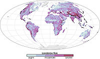 Global landslide risks
 -
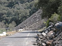 Ferguson Slide on California State Route 140 in June 2006
 -
 Trackside rock slide detector on the UPRR Sierra grade near Colfax, CA


Prehistoric landslides
- tsunamis in Doggerland and other areas connected to the North Sea. A total volume of 3,500 km3 (840 cu mi) debris was involved; comparable to a 34 m (112 ft) thick area the size of Iceland. The landslide is thought to be among the largest in history.[citation needed]
- Landslide which moved Heart Mountain to its current location, the largest continental landslide discovered so far. In the 48 million years since the slide occurred, erosion has removed most of the portion of the slide.
- Flims Rockslide, ca. 12 km3 (2.9 cu mi), Switzerland, some 10,000 years ago in post-glacial Pleistocene/Holocene, the largest so far described in the Alps and on dry land that can be easily identified in a modestly eroded state.[54]
- The landslide around 200 BC which formed Lake Waikaremoana on the North Island of New Zealand, where a large block of the Ngamoko Range slid and dammed a gorge of Waikaretaheke River, forming a natural reservoir up to 256 metres (840 ft) deep.
- Cheekye Fan, British Columbia, Canada, ca. 25 km2 (9.7 sq mi), Late Pleistocene in age.
- The Manang-Braga rock avalanche/debris flow may have formed Marsyangdi Valley in the Annapurna Region, Nepal, during an interstadial period belonging to the last glacial period.[55] Over 15 km3 of material are estimated to have been moved in the single event, making it one of the largest continental landslides.[citation needed]
- Tsergo Ri landslide, a massive slope failure 60 km north of Kathmandu, Nepal, involving an estimated 10–15 km3.[56] Prior to this landslide the mountain may have been the world's 15th mountain above 8000m.
Historical landslides
- The 1806 Goldau landslideon 2 September 1806
- The Cap Diamant Québec rockslideon 19 September 1889
- Frank Slide, Turtle Mountain, Alberta, Canada, on 29 April 1903
- Khait landslide, Khait, Tajikistan, Soviet Union, on 10 July 1949
- A magnitude 7.5 earthquake in Yellowstone Park (17 August 1959) caused a landslide that blocked the Madison River, and created Quake Lake.
- Monte Toc landslide (260 million cubic metres; 9.2 billion cubic feet) falling into the Vajont Dam basin in Italy, causing a megatsunami and about 2000 deaths, on 9 October 1963
- Hope Slide landslide (46 million cubic metres; 1.6 billion cubic feet) near Hope, British Columbia on 9 January 1965.[57]
- The 1966 Aberfan disaster
- Tuve landslide in Gothenburg, Sweden on 30 November 1977.
- The 1979 Abbotsford landslip, Dunedin, New Zealand on 8 August 1979.
- The eruption of Mount St. Helens (18 May 1980) caused an enormous landslide when the top 1300 feet of the volcano suddenly gave way.
- Valtellina disaster(1987) Italy
- Thredbo landslide, Australia on 30 July 1997, destroyed hostel.
- Vargas State, Venezuela, in December, 1999, causing tens of thousands of deaths.
- 2005 La Conchita landslide in Ventura, Californiacausing 10 deaths.
- 2006 Southern Leyte mudslide in Saint Bernard, Southern Leyte, causing 1,126 deaths and buried the village of Guinsaugon.
- 2007 Chittagong mudslide, in Chittagong, Bangladesh, on 11 June 2007.
- 2008 Cairo landslideon 6 September 2008.
- The 2009 Peloritani Mountains disaster caused 37 deaths, on October 1.[58]
- The 2010 Uganda landslide caused over 100 deaths following heavy rain in Bududaregion.
- Zhouqu county mudslide in Gansu, China on 8 August 2010.[59]
- Devil's Slide, an ongoing landslide in San Mateo County, California
- Rio de Janeiro, Brazil on 11 January 2011, causing 610 deaths.[60]
- .
- 2014 Oso mudslide, in Oso, Washington
- 2017 Mocoa landslide, in Mocoa, Colombia
- 2022 Ischia landslide
Extraterrestrial landslides
Evidence of past landslides has been detected on many bodies in the solar system, but since most observations are made by probes that only observe for a limited time and most bodies in the solar system appear to be geologically inactive not many landslides are known to have happened in recent times. Both Venus and Mars have been subject to long-term mapping by orbiting satellites, and examples of landslides have been observed on both planets.
-
 Before and after radar images of a landslide on Venus. In the center of the image on the right, the new landslide, a bright, flow-like area, can be seen extending to the left of a bright fracture. 1990 image.
 -
 Landslide in progress on Mars, 2008-02-19


Landslide mitigation
- Geometric methods, in which the geometry of the hillside is changed (in general the slope);
- Hydrogeologicalmethods, in which an attempt is made to lower the groundwater level or to reduce the water content of the material
- Chemical and mechanical methods, in which attempts are made to increase the shear strength of the unstable mass or to introduce active external forces (e.g. nailing) or passive (e.g. structural wells, piles or reinforced ground) to counteract the destabilizing forces.
See also
References
- ^ "Landslide synonyms". thesaurus.com. Roget's 21st Century Thesaurus. 2013. Archived from the original on 24 September 2020. Retrieved 16 March 2018.
- ISBN 9780071778343, 2012
- ^ "USGS factsheet, Landslide Types and Processes, 2004". Archived from the original on 2020-10-04. Retrieved 2020-08-28.
- ^ S2CID 38328696.
- ISSN 0025-3227.
- ^ OCLC 8206777258., at the introductory section.
- ^ Merzdorf, Jessica. "Climate Change Could Trigger More Landslides in High Mountain Asia". Climate Change: Vital Signs of the Planet. NASA's Goddard Space Flight Center. Archived from the original on 2023-02-04. Retrieved 2023-02-04.
- from the original on 2022-03-06. Retrieved 2021-02-23.
- ^ ISSN 0013-7952.
- ^ S2CID 133681894.
- S2CID 221110680.
- ISSN 0013-7952.
- ^ from the original on 2021-04-03. Retrieved 2018-05-26.
- ^ from the original on 2021-03-30. Retrieved 2018-05-26.
- ISSN 0013-7952.
- from the original on 2020-03-04. Retrieved 2019-01-09.
- ISSN 1561-8633.
- S2CID 55516702.
- ISSN 0013-7952.
- S2CID 245941223.
- S2CID 132940118.
- ISSN 0013-7952.
- S2CID 133852769.
- ^ Varnes D. J., Slope movement types and processes. In: Schuster R. L. & Krizek R. J. Ed., Landslides, analysis and control. Transportation Research Board Sp. Rep. No. 176, Nat. Acad. oi Sciences, pp. 11–33, 1978.
- ^ Cruden, David M., and David J. Varnes. "Landslides: investigation and mitigation. Chapter 3-Landslide types and processes." Transportation research board special report 247 (1996).
- ^ Hutchinson, J. N. "General report: morphological and geotechnical parameters of landslides in relation to geology and hydrogeology." International symposium on landslides. 5. 1988.
- ^ Hungr O, Evans SG, Bovis M, and Hutchinson JN (2001) Review of the classification of landslides of the flow type. Environmental and Engineering Geoscience VII, 221-238.
- S2CID 15955986.
- ^ ISBN 978-0-13-860958-0.
- S2CID 135013342.
- S2CID 135078422.
- ^ .
- from the original on 2022-03-06. Retrieved 2021-02-23.
- from the original on 2021-10-12. Retrieved 2021-02-23.
- PMID 30659201.
- from the original on 2022-08-08. Retrieved 2023-04-10.
- S2CID 219948261.
- ^ Johnson, B.F. (June 2010). "Slippery slopes". Earth magazine. pp. 48–55. Archived from the original on 2014-02-22. Retrieved 2013-08-28.
- .
- ^ "Ancient Volcano Collapse Caused A Tsunami With An 800-Foot Wave". Popular Science. Archived from the original on 2017-08-29. Retrieved 2017-10-20.
- ISBN 978-1-4020-6511-8
- .
- S2CID 128608263.
- .
- ^ Cardenas, IC (2008). "Landslide susceptibility assessment using Fuzzy Sets, Possibility Theory and Theory of Evidence. Estimación de la susceptibilidad ante deslizamientos: aplicación de conjuntos difusos y las teorías de la posibilidad y de la evidencia". Ingenieria e Investigación. 28 (1).
- ^ Cardenas, IC (2008). "Non-parametric modeling of rainfall in Manizales City (Colombia) using multinomial probability and imprecise probabilities. Modelación no paramétrica de lluvias para la ciudad de Manizales, Colombia: una aplicación de modelos multinomiales de probabilidad y de probabilidades imprecisas". Ingenieria e Investigación. 28 (2).
- .
- (PDF) from the original on 2022-10-09.
- S2CID 129661820.
- S2CID 128534998.
- .
- ^ Rose, Nick D.; Hunger, Oldrich (17 February 2006). "Forecasting potential slope failure in open pit mines" (PDF). Journal of Rock Mechanics & Mining Sciences. Archived from the original (PDF) on 2017-07-13. Retrieved 20 August 2015.
- (PDF) from the original on 2022-10-09.
- ^ Weitere Erkenntnisse und weitere Fragen zum Flimser Bergsturz Archived 2011-07-06 at the Wayback Machine A.v. Poschinger, Angewandte Geologie, Vol. 11/2, 2006
- ^ Fort, Monique (2011). "Two large late quaternary rock slope failures and their geomorphic significance, Annapurna, Himalayas (Nepal)". Geografia Fisica e Dinamica Quaternaria. 34: 5–16.
- .
- ^ "Hope Slide". BC Geographical Names.
- .
- ^ "Large landslide in Gansu Zhouqu August 7". Easyseosolution.com. 19 August 2010. Archived from the original on 24 August 2010.
- ^ "Brazil mudslide death toll passes 450". Canadian Broadcasting Corporation. 13 January 2011. Archived from the original on 1 March 2011. Retrieved 13 January 2011.
- ISBN 978-1-78985-824-2
External links
- United States Geological Survey site (archived 25 March 2002)
- British Geological Survey landslides site
- British Geological Survey National Landslide Database
- International Consortium on Landslides
| Investigation and instrumentation |
| ||||||
|---|---|---|---|---|---|---|---|
| Soil |
| ||||||
| Structures (Interaction) |
| ||||||
| Mechanics |
| ||||||
| Numerical analysis software | |||||||
| Related fields | |||||||
| International | |
|---|---|
| National | |
| Other | |