
Bridges of York

There are nine bridges across the River Ouse and eighteen smaller bridges and passages across the narrower River Foss within the city of York, England.
Bridges over the Ouse

The earliest bridge, built by the
North to south, the bridges are:
| Bridge | Built | Type |
|---|---|---|
| A1237 — Outer Ring Road, Western and Northern | 1987 | Road |
Clifton Bridge |
1963 | Road |
| Scarborough Railway Bridge | 1844 | Rail and pedestrian |
| Lendal Bridge | 1863 | Road |
| Ouse Bridge | 1821 | Road |
| Skeldergate Bridge | 1881 | Road |
| Millennium Bridge | 2001 | Pedestrian |
| A64 — Outer Ring Road, Southern and Eastern | 1976 | Road |
| Naburn railway bridge | 1871 | Pedestrian |
Clifton Bridge (1963)

A temporary bridge over the River Ouse at Clifton was built by the British Army in 1961 on the site of an old ferry crossing to handle additional vehicle traffic caused by the wedding of the Duke and Duchess of Kent at York Minster. A permanent bridge was opened officially on 28 October 1963. The bridge is built from 4,000 tons of concrete and 50 tons of reinforced steel.[1][2]
Scarborough Railway Bridge (1845)

The second bridge across the Ouse was the Scarborough Railway Bridge, built in 1845 to carry the railway line between York and
Lendal Bridge (1863)

Lendal Bridge stands on the site of a former rope-ferry where the city walls break for the River Ouse. This was the ferry used by Florence Nightingale when she visited York en route to Castle Howard in 1852[citation needed].
The bridge connects two medieval towers: Lendal Tower on the east bank and Barker Tower on the west bank. It was designed by civil engineer Thomas Page, who also designed London's Westminster Bridge. It is made of cast iron, and has a single span of 175 feet (53 m).[7]
_(cropped).jpg)
Page's bridge was the second attempt to build a bridge on the site. The first, begun in 1860 by William Dredge, collapsed during construction, and five workmen were killed. Parts of the structure were later taken to Scarborough and used in the Valley Bridge there.[8]
In 1861, permission was obtained from Parliament for a new bridge to be built, and the Corporation of York requested Thomas Page to design a replacement. His
Lendal Bridge links Station Road with Museum Street and thus York railway station with York Minster, and is part of York's Inner Ring Road. The Maltings pub, near the south end of the bridge, was formerly named the "Lendal Bridge Hotel".[12]
Lendal Bridge was used in
Motor traffic (except for buses) was restricted daily from 10.30 a.m. to 5.00 p.m. on Lendal Bridge during a six-month trial period from August 2013 to February 2014. The trial objectives were to establish whether a permanent restriction would reduce congestion in York city centre, improve the environment and improve the reliability of certain bus routes. The traffic ban was enforced with
Ouse Bridge (1821)

The original Roman bridge over the Ouse was eventually replaced by a wooden bridge built further downstream by the
It is a
Skeldergate Bridge (1881)
.jpg)
Skeldergate Bridge links the
Millennium Bridge (2001)
53°56′41.33″N 1°4′55.42″W / 53.9448139°N 1.0820611°W

The Millennium Bridge, built to a competition-winning design by
The bridge also acts a meeting place for local people, as it has a waist height shelf spanning the whole structure which facilitates sitting and admiring the view. Increasingly it is used as a circular walk from the city centre taking in the New Walk on the east bank and Terry Avenue and
At night the bridge is illuminated by banks of lights in different colours, so that the colour of illumination changes every few seconds.
Supplies for Fulford Barracks were brought in by river near this location, and the remains of a narrow gauge railway may be seen on the eastern bank of the river a few yards toward the city. There used to be a rope ferry at this location as well. There may have been a rope ferry at one time, but in the 20th century it was a sculled ferry (rowed by a single oar at the stern) right into the 1950s when the ferry boat became motorised. It was particularly used by the Terry's workers (with their bikes), who lived on the Fulford side of the Ouse.
-
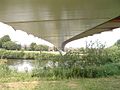
 The Millennium Bridge from Fulford.
 -
 Below the bridge from Fulford.
 -
 Millennium Bridge


Naburn Railway Bridge (1871)

Outside the outer ring-road, the Naburn swing bridge, built in 1871, used to carry the York-Selby railway until it was diverted in 1983. The bridge now constitutes part of the York & Selby cycle path, connecting the Trans Pennine trail to York.[25] It is also known as the "Fisherman Bridge" due to a large metal sculpture of a fisherman with bike and dog, sitting on top which was added in 2000 as part of the York Council "Creative Communities 2000" scheme.[26]
Bridges over the Foss

From north to south, to the
| Bridge | Built | Type |
|---|---|---|
| A1237 — Outer Ring Road, Western and Northern | 1987 | Road |
| Church Lane Bridge | c. 1850 [27] | Road |
| Station Avenue Bridge | c. 1890 [28] | Pedestrian |
| Link Road Bridge | c. 1850 [29] | Road |
| Yearsley Grove pedestrian bridge | c. 1890 [30] | Pedestrian |
| Huntington Road Bridge | c. 1850 [31] | Road |
| Fossway Bridge | c. 1940 [32] | Road |
Foss Islands Branch Line bridge |
c. 1880 | Pedestrian |
| Monk Bridge ( A1036 ) |
1794[33] | Road |
| Foss Bank Bridge ( A1036 ) |
1998 | Road |
| Layerthorpe Bridge ( A1036 ) |
1997[34] | Road |
| Defra pedestrian bridge | 1931 | Pedestrian |
| Hungate Bridge | 2011[35] | Pedestrian |
| Rowntree Wharf pedestrian bridge | c. 1990 | Pedestrian |
| Foss Bridge | 1812 | Road |
| Piccadilly Bridge | 1914 | Road |
| Castle Mills Bridge ( A1036 ) |
1956[36] | Road |
| Blue Bridge | 1930[37] | Pedestrian |
Many of these are small pedestrian crossings or unobtrusive modern bridges carrying main roads. The following are more notable:
Monk Bridge (1794)
Monk Bridge is a single-arched ashlar bridge with a span of approximately 20 feet (6 m). It carries traffic between central York and Heworth and was built in 1794 to designs by Peter Atkinson the elder. In 1924–6, the bridge was widened and the upper part rebuilt.[17]
Pedestrian bridge from Foss Island Road to Defra site (1931)
Hungate Bridge (2011)

Opened in September 2011,[35] Hungate bridge is a cable-stayed cycle and foot bridge that links Navigation Road and Palmer Street. It has an 85 feet (26 m)[39] span with a single supporting mast on the north bank.[40]
National Cycle Network Route 658 uses the bridge.[41] It is also on the route of the Way of the Roses coast to coast route and is part of York's network of traffic-free cycleways.[35]
Foss Bridge (1812)
The Foss Bridge, a single
Blue Bridge (1930)
.jpg)
The Blue Bridge crosses the River Foss just above its confluence with the River Ouse. The original bridge on the site was built in 1738, the current one being constructed in 1929–30.
In the early 1730s a section of the eastern river bank of the Ouse was improved, at the expense of the city, to create an area lined with trees along which the citizens could promenade. It proved so popular that within a few years this New Walk was extended further south past the junction with the Foss by way of a wooden drawbridge.
References
- ^ "Building bridges". York Press. 9 April 2001. Retrieved 1 August 2017.
- ^ "Spanning the Ouse". York Press. 17 September 2001. Archived from the original on 1 February 2014. Retrieved 25 January 2014.
- ^ "Rail passengers, York residents and visitors to the city are being thanked for their patience after the old bridge deck of Scarborough Rail Bridge was removed and a new one installed". City of York Council. 23 February 2015. Retrieved 8 December 2015.
- ^ "City Connect York: Scarborough Bridge". cyclecityconnect.co.uk. Retrieved 24 April 2019.
- ^ "Scarborough Bridge project". www.york.gov.uk. Retrieved 24 April 2019.
- ^ "Scarborough Bridge in York is open again". Minster FM. 18 April 2019. Retrieved 24 April 2019.
- ^ "When Disaster Struck Lendal Bridge". York Press. 11 August 2014. Retrieved 1 August 2017.
- ISBN 9781445627717. Retrieved 15 April 2015.
- ^ "Lendal Bridge". History of York. Retrieved 1 August 2017.
- ^ Historic England. "EAST LODGE OF LENDAL BRIDGE LENDAL BRIDGE AND ATTACHED TOLLHOUSES (1257475)". National Heritage List for England. Retrieved 15 June 2015.
- ^ "'Tommy Burns' in York". The Huddersfield Chronicle and West Yorkshire Advertiser. 25 August 1892. p. 3.
- ISBN 9781445644769.
- Creative England. Retrieved 29 November 2017.
- ^ "Lendal bridge trial evaluation report". City of York Council. Retrieved 31 July 2015.
- ^ "York History". Archived from the original on 28 May 2011. Retrieved 17 May 2020.
- ^ "Ouse Bridge (York, 1821)". Structurae. Retrieved 17 May 2020.
- ^ ISBN 0-14-071061-2.
- ^ Historic England. "OUSE BRIDGE AND ATTACHED FLIGHTS OF STEPS (1259354)". National Heritage List for England. Retrieved 15 June 2015.
- ^ "York (Skeldergate Bridge) Improvement Act 1875".
- ^ "Bridges of York - Ouse Bridge, Lendal Bridge and Skeldergate Bridge". www.york-united-kingdom.co.uk. Retrieved 17 May 2020.
- ^ "Skeldergate Bridge". Yorkshire Gazette. 12 March 1881.
- ^ "Skeldergate Bridge: History of York". www.historyofyork.org.uk. Retrieved 1 August 2017.
- ^ Historic England. "SKELDERGATE BRIDGE AND ATTACHED TOLLHOUSE, ABUTMENT WALLS AND STEPS (1256602)". National Heritage List for England. Retrieved 15 June 2015.
- ^ "York Millennium Bridge". Retrieved 17 May 2020.
- ^ "Trans Pennine Trail". Retrieved 11 September 2012.
- ^ "Cycle the Solar System". Solar.york.ac.uk. Retrieved 25 January 2014.
- ^ "Yorkshire CLVII.15". National Library of Scotland. Retrieved 26 June 2023.
- ^ "Yorkshire Sheet 157". National Library of Scotland. Retrieved 26 June 2023.
- ^ "Yorkshire Sheet 157". National Library of Scotland. Retrieved 26 June 2023.
- ^ "Yorkshire CLXXIV.3". National Library of Scotland. Retrieved 26 June 2023.
- ^ "Yorkshire Sheet 174". National Library of Scotland. Retrieved 26 June 2023.
- ^ "Yorkshire Sheet CLXXIV.NE". National Library of Scotland. Retrieved 26 June 2023.
- ^ "Monument record MYO315 - Monk Bridge". York Historic Environment Record.
- ^ "Monument record MYO312 - Layerthorpe Bridge". York Historic Environment Record.
- ^ a b c "New bridge opens in York". York Press. Retrieved 23 April 2019.
- ^ "Monument record MYO303 - Castle Mills Bridge". York Historic Environment Record.
- ^ a b "Blue Bridge". Open Plaques. Retrieved 19 September 2016.
- ISBN 1-904474-06-3.)
{{cite book}}: CS1 maint: multiple names: authors list (link - ^ "KonceptX - Innovative designs in buildings". KonceptX. Archived from the original on 23 April 2019. Retrieved 23 April 2019.
- ^ "Hungate Footbridge, York - SH Structures". www.shstructures.com. Retrieved 23 April 2019.
- ^ "Way: Hungate Bridge (128105723)". OpenStreetMap. Retrieved 23 April 2019.
- ISBN 0-9542749-0-3.
- ^ Historic England. "FOSS BRIDGE (1257827)". National Heritage List for England. Retrieved 15 June 2015.
- ^ Combe, William (1785). The history and antiquities of the city of York, Volume 2. York: Printed by A. Ward; and sold by W. Tesseyman, J. Todd, H. Sotheran, T. Wilson, N. Frobisher and R. Spence, booksellers. p. 187. Retrieved 14 September 2016.
- ^ "Georgian: A New Walk". York Museums Trust. Retrieved 14 September 2016.
- ^ a b "'City walls, bars, posterns and bridges', in A History of the County of York: the City of York, ed. P M Tillott (London, 1961), pp. 510-520". British History Online. Retrieved 14 September 2016.
- ^ Drake, Francis (1788). "Eboracum: Or, The History and Antiquities of the City of York, from Its Origin to this Time, Volume 2". York: T. Wilson and R. Spence. p. 2. Retrieved 14 September 2016.
- ^ "OTHER NEWS - York's Blue Bridge to be removed for repairs". Minster FM. 14 May 2020. Retrieved 17 May 2020.
- The Fairest Arch in England: Old Ouse Bridge, York, and its Buildings ISBN 1-874454-26-4