
Ligurian Sea
This article needs additional citations for verification. (December 2007) |


The Ligurian Sea (
Geography
The sea borders Italy as far as its border with France, and the French island of Corsica. In the east, the sea borders the Tyrrhenian Sea, while in the west it borders the Mediterranean Sea proper. Genoa is the most prominent city in the area. The northwest coast is noted for its scenic beauty and favourable climate.
The Gulf of Genoa is its northernmost part. The ports of Genoa and La Spezia are on its rocky coast. It reaches a maximum depth of more than 2,800 m (9,300 ft) northwest of Corsica.
According to a 1983 study, since 1977 a series of experimental analyses on sea-level variations at Genoa and Imperia highlighted "the existence of a seiche wave with a mean period of 5.8 hours", whose reasons weren't yet explained at that time. The Ligurian Sea was modeled as a rectangular semi-closed basin with a longitudinal length of 40 km (25 mi) and a transversal one of 10 km (6.2 mi), in an average constant depth of 2,000 m (6,600 ft; 1,100 fathoms).[1]
Extent
The International Hydrographic Organization defines the limits of the Ligurian Sea as follows:[2]
On the Southwest. A line joining Cape Corse (Cape Grosso, 9°23′E) the Northern point of Corsica to the frontier between France and Italy (7°31′E).
On the Southeast. A line joining Cape Corse with Tinetto Island (44°01′N 9°51′E / 44.017°N 9.850°E) and thence through Tino and Palmaria Islands to San Pietro Point (44°03′N 9°50′E / 44.050°N 9.833°E) on the Coast of Italy.
On the North The Ligurian Coast of Italy.
Flowings
The Ligurian Sea is attraversed by the
Conservation
In order to provide protection for the numerous
Image gallery
-

-

-
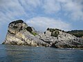
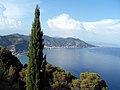
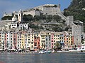 Portovenere
 -
-
-

-

-

-

-

-

-

-

-
-
-
-

-

-
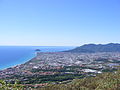
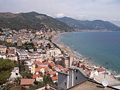
 Ventimiglia


References
- OCLC 4640460944.
- ^ "Limits of Oceans and Seas, 3rd edition" (PDF). International Hydrographic Organization. 1953. Archived from the original (PDF) on 5 October 2018. Retrieved 28 December 2020.
- (PDF) from the original on November 20, 2008. At the introductory paragraph.