
List of Indian states and union territories by highest point

This is the alphabetical list of the highest points of the Indian states and union territories.
States
Union territories
Gallery
-
 Kangchenjunga (8,586 m)
 -
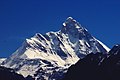 Nanda Devi (7,816 m)
 -
 Saltoro Kangri (7,742m)
 -
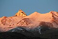
 Nun Kun (7,135 m)
 -
 Kangto (7,090 m)
 -
 Reo_Purgyil(6,816 m)
 -
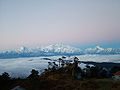 Sandakphu (3,636 m)
 -
 Anamudi (2,695 m)
 -
 Gurushikhar Mount Abu(1,722 m)
 -
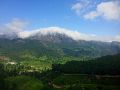
 Kalsubai (1,646 m)


.jpg)


See also
- List of hill stations in India
- List of mountains in India
- List of mountain passes of India
- List of the tallest statues in India
- List of tallest buildings in India
- List of tallest structures in India
- Tourism in India
References
- ^ "Kangchenjunga - Peakware". Archived from the original on 2009-02-20. Retrieved 2008-12-27.
- ^ "Nanda Devi - Peakware".
- ^ "Saramati". Peakbagger.com.
- ^ "Sandakphu". Archived from the original on 2008-12-25.
- ^ "Hills Of Manipur". Archived from the original on 2013-03-23.
- ^ "Manipur Tourism District:Senapati". Archived from the original on 2017-04-03. Retrieved 2014-10-14.
- ^ "Anai Mudi". Peakbagger.com.
- ^ "A Beautiful Green Hills". Archived from the original on 2007-09-29.
- ^ "Phawngpui, Mizoram". Archived from the original on 2009-05-02. Retrieved 2008-12-27.
- ISBN 978-1-4093-4267-0.
- ^ "Assam Hills". Birdlife International.
- ^ Ganesh Prabhu (2014-03-19). "Udupi-Chikmagalur: A constituency that's beset by problems". The Hindu.
- ^ "Guru Shikhar, Mount Abu". Archived from the original on 2009-04-10.
- ^ The Geography of India: Sacred and Historic Places
- ^ The britannica Quiqmaster
- ^ "Deomali Peak in Koraput".
- ^ "Kalsubai". Archived from the original on 2011-07-22. Retrieved 2008-12-27.
- ISBN 978-81-7024-643-5.
- ^ "Parasnath". Archived from the original on 2005-10-18.
- ISBN 978-81-7387-135-1.
- ^ छत्तीसगढ़ के सर्वोच्च शिखर गौरलाटा पर 5 वर्ष की एडविना कांत
- ^ "National Mineral Development Corporation, Dantewada district, Chhattisgarh". Archived from the original on 2017-03-01. Retrieved 2014-11-06.
- ^ Bailadila Hills, Dantewada district, Chhattisgarh
- ^ Background Information about the State of Gujarat Archived 2017-08-20 at the Wayback Machine, dgfasli.nic.in
- ^ "The tiger in the tale". The Times of India. 2011-12-12.
- ^ "GAZETTEER RUPNAGAR". Archived from the original on 2016-07-16. Retrieved 2014-09-25.
- ^ "Wikimapia - Doli Gutta (965m) - Telangana Chhattisgarh border. Possibly highest point in Telangana".
- ^ "Highest Peaks in India".
- ^ "Peakbagger - Betalongchhip, India".
- ^ Fort Someshwar, West Champaran district, Bihar
- ^ "Saltoro Kangri, Pakistan/India". Peakbagger.com.
- ^ "Top 10 highest Himalaya mountain peaks in India".
- ^ "Top 10 highest peaks of India".
- ^ "Nun, India". Peakbagger.com.
- ^ "Saddle Peak -- Britannica".