
List of Interstate Highways in Michigan
| Interstate Highways of the State Trunkline Highway System | ||
|---|---|---|
Business Spur Interstate nn (BS I‑nn) | | |
| System links | ||
.svg)
.svg)
The Interstate Highways in Michigan are the segments of the national
There are also 26 current
Description
MDOT is the agency responsible for the day-to-day maintenance and operations of the
The Interstate Highway System covers about 1,240 miles (2,000 km) in the state and consists of four
History
Construction of the first
.jpg)
The Interstate Highway System was authorized by the
The MSHD asked for 600 miles (970 km) in additions to the state's Interstate mileage in 1968. Included in these requests were the extension of the Davison Freeway (now M-8), the extension of I-69 from Marshall to Port Huron, and the conversion of the northern sections of US Highway 23 (US 23) and US 131.[25] Of these, the I-69 proposal was approved when the United States Congress extended it to terminate in at I-75 in Flint. The highway was lengthened twice more: to I-475 in 1973 and to Port Huron on February 10, 1987.[26] These last two extensions were classified non-chargeable mileage, or segments not financed through the Interstate Highway fund.[27] The federal government paid 90 percent of the cost of the chargeable mileage originally approved.[18]
The last of Michigan's Interstates to be completed was I-69, the last segment of which opened in 1992.[28] Since then, the United States Congress has designated an additional primary Interstate, I-73 in the state. All studies by MDOT on that highway were cancelled in 2001 over funding concerns.[29] Press reports state there is a "lack of need" for the freeway in the state,[30] and the department has no plans to revive I-73 as of 2011.[31] If built as designated, I-73 would cross into Michigan near Toledo, Ohio, and connect Jackson, Lansing, and Clare to I-75 at Grayling.[32]
Primary Interstates
| Number | Length (mi)[2] | Length (km) | Southern or western terminus | Northern or eastern terminus | Formed | Removed | Notes | |
|---|---|---|---|---|---|---|---|---|
| 202.317 | 325.598 | I-69 at Kinderhook Township | Hwy. 402 at Port Huron | 1967[33] | current | Last Interstate completed in Michigan when finished in 1992;[28] segments named the Chevrolet (or Chevrolet-Buick) Freeway, or the Pearl Harbor or Purple Heart highways[34] | ||
| 395.916 | 637.165 | I-75 at Erie Township | International Bridge at Sault Ste. Marie | 1959[21] | current | I-75 is the longest | ||
| 275.398 | 443.210 | I-94 at New Buffalo Township | Hwy. 402 at Port Huron | 1959[20] | current | First Interstate Highway completed between state borders in 1960;[23] sections named the Detroit Industrial or Edsel Ford freeways[37] | ||
| 192.032 | 309.046 | Bus. US 31 in Norton Shores |
I-75 in Detroit | 1959[20] | current | One section previously known as the Brighton–Farmington Freeway,[12] other sections named the Jeffries[38] and Rosa Parks freeways;[39] completed in 1977[12] | ||
- Primary Interstates
-
 I-69 approaching exit 70
 -
 Looking south along I-75 (Chrysler Freeway) at the Detroit skyline
 -
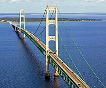 Mackinac Bridge and I-75 over the Straits of Mackinac
 -
 I-94 at Park Road near Coloma
 -
 I-96 near its western terminus
 -
 Local-express lanesalong I-96 (Jeffries Freeway)
 -
 Twin-span Blue Water Bridge carrying I-69 and I-94


Auxiliary Interstates
| Number | Length (mi)[2] | Length (km) | Southern or western terminus | Northern or eastern terminus | Formed | Removed | Notes | |
|---|---|---|---|---|---|---|---|---|
| 3.374 | 5.430 | I-94 and M-66 in Battle Creek | M-66 in Battle Creek | 1961[40] | current | Called the Sojourner Truth Downtown Parkway,[41] or The Penetrator,[42][c] I-194 serves as a spur into downtown Battle Creek and was completed in 1966.[44] | ||
| 30.073 | 48.398 | Bus. US 31 in Norton Shores |
I-96 in Grand Rapids | 1959[20] | 1963[45] | Now the western end of I-96, I-196 was a spur from Grand Rapids to Muskegon completed in 1962.[46] | ||
| 80.629 | 129.760 | I-94/US 31 in Benton Township near Benton Harbor | I-96/M-37 in Grand Rapids | 1963[45] | current | The Gerald R. Ford Freeway[47] was completed in 1974[48] as a connector from Grand Rapids to I-94 in the Benton Harbor–St. Joseph area. | ||
| 35.026 | 56.369 | Frenchtown Township near Newport |
I-96, I-696 and M-5 in Novi | 1974[49] | current | Completed in 1977[50] as a partial western bypass of Detroit. | ||
| 3.189 | 5.132 | I-196 and US 131 in Grand Rapids | I-96 in Walker | 1962[51] | current | Michigan was granted approval to remove signage referring to I-296 on December 3, 1979.[52] The freeway is signed as US 131 and connects I-96 and I-196 near downtown Grand Rapids. | ||
| 1.147 | 1.846 | BS I-375 in Detroit | I-75 in Detroit | 1964[53] | current | I-375 is the southern end of the Walter P. Chrysler Freeway,[54] and as of 2007[update] it was the shortest signed Interstate in the country,[53] but I-110 in Texas has been signed since then.[55] I-375 is a spur connecting the Detroit Riverfront area to I-75. | ||
| 16.866 | 27.143 | I-75 in Grand Blanc Township | I-75/US 23 in Mount Morris Township | 1973[56] | current | Called the David Dunbar Buick Freeway,[56] or the UAW Freeway,[57] I-475 is a loop into Downtown Flint completed in 1981.[58] | ||
| 11.481 | 18.477 | Delta Township |
I-96 and Delhi Township
|
1963[59] | current | I-496 is the R. E. Olds Freeway,[60] a loop into Downtown Lansing completed in 1970[61] | ||
| 7.929 | 12.760 | Buena Vista Township |
I-75/US 23 in Zilwaukee Township | 1971[62] | current | I-675 is a loop into downtown Saginaw. | ||
| 28.368 | 45.654 | I-96/I-275 and M-5 in Novi | I-94 in St. Clair Shores | 1963[63] | current | Walter P. Reuther Freeway;[64] completed in 1989[65] | ||
| ||||||||
- Auxiliary Interstates
-
 I-194/M-66, the Sojourner Truth Downtown Parkway
 -
 I-196 entering downtown Grand Rapids
 -
 Looking south at the I-96/I-275 split
 -
 Unsigned I-296 from across the Grand River
 -
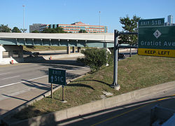 Northern end of I-375 where it merges into I-75 near Gratiot Avenue in Detroit
 -
 I-496 in Lansing
 -
 I-675 crossing Schaefer Street in Saginaw
 -
 Pedestrian plazas along I-696 in Oak Park
 -
 Satellite image of the junction of I-96, I-275 and I-696


.png)
Proposed Interstates
| Number | Southern or western terminus | Northern or eastern terminus | Notes |
|---|---|---|---|
I-67
|
South Bend, IN
|
Kalamazoo | Proposed designation in 1957 for what was shifted to become I-69[66][67] |
| Benton Harbor | Grand Rapids | Later proposed in 1958 and 1963 for what became I-196[46][67] | |
| Newport | Novi | Proposed in 1958 for what became I-275[67] | |
| Ottawa Lake | Grayling[d] | Designated by Congress in 1991 and 1995, but all future study halted by MDOT; essentially removed from consideration[29][32][68] | |
Erie
|
Port Huron | Proposed designation in 1957 for what became I-94 from Detroit to Port Huron and cosigned with I-75 from Detroit to state line[66] | |
| Benton Harbor | Detroit | Proposed designation in 1957 for what became I-94 from Detroit to Benton Harbor[66] | |
| Muskegon | Grand Rapids | Proposed designation in 1957 for what became I-196, and now I-96 from Grand Rapids to Muskegon[66] | |
| Novi | St. Clair Shores | Proposed designation in 1958 for what became I-696[67] | |
| — | Grand Rapids | Mackinaw City | Request from 1968 for a designation along US 131[69][70] |
| — | Standish | Cheboygan | Request from 1968 for a designation along US 23[69][70] |
Business routes
| Number | Length (mi)[2] | Length (km) | Southern or western terminus | Northern or eastern terminus | Formed | Removed | Notes | |
|---|---|---|---|---|---|---|---|---|
BL I-69
|
5.202 | 8.372 | I-69 on the Ovid–Coldwater township line | I-69 in Coldwater | 1967[33] | current | ||
BL I-69
|
4.891 | 7.871 | I-69 on the Carmel–Eaton township line | I-69 in Charlotte | 1974[71] | current | ||
BL I-69
|
14.668 | 23.606 | Delta Township |
I-69 in Bath Township
|
1987[72] | current | Longest business route in the state, serves Lansing and East Lansing[2] | |
BL I-69
|
5.408 | 8.703 | I-94/I-69 in Port Huron Township | I-94/I-69 in Port Huron | 1984[73] | current | ||
BL I-75
|
8.384 | 13.493 | I-75 in Bloomfield Township | I-75 in Auburn Hills | 1963[74] | current | Follows | |
BL I-75
|
7.338 | 11.809 | Buena Vista Township |
I-75/US 10/US 23 in Zilwaukee Township | 1961[75] | 1971[76] | Previously served downtown Saginaw[76] | |
BS I-75
|
3.047 | 4.904 | I-75/US 23 and US 10 in Monitor Township | M-25 in Bay City | 1961[75] | current | Previously part of a business loop[76] | |
BL I-75
|
5.525 | 8.892 | I-75 in Horton Township | I-75/M-55 in Ogemaw Township | 1973[77] | current | Replaced Bus. M-76 through West Branch[77]
| |
BL I-75
|
6.935 | 11.161 | I-75 and M-18 in Higgins Township | I-75 on the Gerrish–Beaver Creek township line | 1973[77] | current | Serves Roscommon[2] | |
BL I-75
|
5.823 | 9.371 | Grayling Township |
I-75 and M-93 in Grayling Township | 1961[75] | current | Serves Grayling[2] | |
BL I-75
|
3.391 | 5.457 | I-75 in Bagley Township | I-75 and M-32 in Gaylord | 1986[78] | current | ||
BL I-75
|
3.975 | 6.397 | I-75 and M-68 in Tuscarora Township | I-75 and M-27 in Tuscarora Township | proposed[79] | — | Would serve Indian River if designated | |
BL I-75
|
4.719 | 7.594 | I-75 and US 2 in St. Ignace | I-75 and Evergreen Shores
|
c. 1960[80] | current | ||
BS I-75
|
5.867 | 9.442 | I-75 in Sault Ste. Marie | Portage Avenue in Sault Ste. Marie | 1962[81] | current | ||
BL I-94
|
10.705 | 17.228 | Lincoln Township |
I-94/US 31 in Benton Township | 1960[82] | current | Serves Benton Harbor and St. Joseph[2] | |
BS I-94
|
2.885 | 4.643 | M-96 in Kalamazoo | I-94 in Comstock Township | 1962[83] | current | Previously a full business loop, truncated in 2019 after Kalamazoo accepted jurisdiction of much of the routing;[84] some portions retained as unsigned highway[85] | |
BL I-94
|
14.052 | 22.615 | I-94 in Battle Creek | I-94 and M-96 in Emmett Township | 1962[83] | current | ||
BL I-94
|
5.707 | 9.185 | I-94 and I-69 in Marshall Township | I-94 in Marengo Township | 1962[83] | current | Serves Marshall[2] | |
BL I-94
|
4.520 | 7.274 | I-94 in Sheridan Township | I-94 in Parma Township | 1962[83] | current | Serves Albion[2] | |
BL I-94
|
10.274 | 16.534 | Blackman Township |
I-94 in Leoni Township | 1962[83] | current | Serves Jackson[2] | |
BL I-94
|
8.436 | 13.576 | I-94 in Ann Arbor | I-94 and Pittsfield Township
|
1962[83] | current | ||
BL I-94
|
8.536 | 13.737 | I-94 in Kimball Township | I-94/I-69 in Port Huron | 1986[86] | current | ||
BS I-96
|
6.160 | 9.914 | Carferry docks in Muskegon | Bus. US 31 in Norton Shores
|
1963[87] | 1984[88] | Replaced BS I-196 | |
BS I-96
|
1.292 | 2.079 | Grand River Avenue in Portland | I-96 in Portland | 1978[89] | 2007[90] | ||
BL I-96
|
13.545 | 21.799 | Watertown Township |
I-96 in Lansing | 1962[91] | current | ||
BL I-96
|
5.415 | 8.715 | I-96 in Howell Township | I-96 in Genoa Township | 1962[92] | current | Serves Howell[2] | |
BL I-96
|
4.365 | 7.025 | M-5 in Farmington Hills | M-5 in Farmington Hills | 1962[92] | current | Now an unsigned highway along Grand River Avenue serving Farmington[93] | |
BS I-96
|
7.033 | 11.319 | I-96 and M-5 in Detroit | Cass and Grand River avenues in Detroit | 1962[92] | 2016 | Was last an unsigned trunkline along Grand River Avenue in Detroit[93] | |
BS I-196
|
6.160 | 9.914 | Carferry docks in Muskegon | Bus. US 31 in Norton Shores
|
1962[94] | 1963[87] | Replaced by BS I-96 | |
BL I-196
|
3.572 | 5.749 | South Haven Township |
I-196/US 31 in South Haven | 1963[95] | current | ||
BL I-196
|
11.508 | 18.520 | I-196/US 31 in Laketown Township | I-196 in Zeeland Township
|
1974[96] | current | Serves Holland[2] | |
BS I-196
|
2.433 | 3.916 | I-196 in Wyoming | Granville Avenue & Clyde Park Avenue on the Wyoming–Grand Rapids city line | 1974[97] | current | Previously extended into Grand Rapids and terminated at US 131 before December 2017[98] | |
BS I-375
|
0.167 | 0.269 | M-3 and M-10 in Detroit | I-375 in Detroit | 1963[53] | current | Unsigned along Jefferson Avenue[e] | |
| 2.381 | 3.832 | I-496 and M-99 in Lansing | I-496 and BL I-96 in Lansing | 1989[101] | 2024[102] | Also designated Connector 496[103] or Capitol Loop I-496 by MDOT[104] | ||
BS I-696
|
18.562 | 29.873 | I-696 and US 24 in Southfield | Jefferson Avenue in Detroit | c. 1961[92] | 1970[105] | Previous designation for the John C. Lodge Freeway, now M-10[105][106] | |
| ||||||||
See also
 Michigan Highways portal
Notes
- ^ The Mackinac Bridge Authority (MBA) is an independent state agency responsible for the Mackinac Bridge and thus maintains that section of the overall highway system. The MBA works with MDOT but does not report to it. The executive secretary of the MBA is appointed by MDOT with MBA approval.[10]
- ^ The Michigan State Highway Department was reorganized into the Michigan Department of State Highways and Transportation on August 23, 1973,[12] and the name was later shortened to its current form in 1978.[13]
- ^ When the MSHD was planning the freeway network in the state, they called all of the auxiliary Interstate Highways, "Penetrator"[43]
- ^ The legislation defining the I-73 corridor specifies Sault Ste. Marie and Detroit as the northern termini, but the Grayling–Sault Ste. Marie or Toledo–Detroit segments overlap I-75 with no requirement to overlap the highway designations. Similarly, Congress included I-94 between Chicago and Port Huron in the I-69 corridor to make it eligible for funding.[32]
References
Footnotes
- ^ a b McNichol (2006), p. 106.
- ^ a b c d e f g h i j k l m n o p q Michigan Department of Transportation (2021). Next Generation PR Finder (Map). Michigan Department of Transportation. Retrieved October 11, 2021.
- ^ Swift (2011), p. 5.
- ^ Hamilton (2007), p. 8.
- ^ a b c Michigan Department of Transportation (July 7, 2015). "Road & Highway Facts". Michigan Department of Transportation. Archived from the original on October 2, 2015. Retrieved August 21, 2015.
- ^ Lewis (2013), p. 253.
- ^ McNichol (2006), pp. 10–11.
- OCLC 893873063. Archived from the original(PDF) on April 16, 2014. Retrieved April 14, 2014.
- ^ McNichol (2006), pp. 57, 121.
- OCLC 9975013.
- ^ Hyde (1993), pp. 147–168.
- ^ a b c Kulsea & Shawver (1980), p. 27.
- ^ Kulsea & Shawver (1980), pp. 30–31.
- ^ Kulsea & Shawver (1980), pp. 17–18.
- ^ MDOT (2010), p. 12.
- .
- OCLC 36250796. Archived from the originalon July 9, 2013. Retrieved October 30, 2012.
- ^ a b c Kulsea & Shawver (1980), p. 19.
- Gross Domestic Product deflatorfigures follow the MeasuringWorth series.
- ^ OCLC 12962635. Retrieved November 21, 2010 – via Google News.
- ^ Newspapers.com.
- ^ OCLC 1554151. Retrieved July 10, 2018 – via Newspapers.com.
- ^ .
- OCLC 12962717.
- OCLC 9802802. Retrieved December 5, 2010 – via Google News.
- ^ Weingroff, Richard (July 16, 2013) [1998]. "Part I: History". The Dwight D. Eisenhower System of Interstate and Defense Highways. Federal Highway Administration. Archived from the original on June 7, 2021. Retrieved August 18, 2013.
- ^ Weingroff, Richard (July 16, 2013) [1998]. "Part II: Mileage". The Dwight D. Eisenhower System of Interstate and Defense Highways. Federal Highway Administration. Archived from the original on June 7, 2021. Retrieved August 18, 2013.
- ^ OCLC 18110507. Retrieved August 11, 2018 – via NewspaperArchive.com.
- ^ a b Debnar, Kari (June 12, 2001). "MDOT Postpones Further Studies Along I-73 Corridor" (Press release). Michigan Department of Transportation. Archived from the original on February 28, 2005. Retrieved September 28, 2010.
- OCLC 761993706. Archived from the original(PDF) on October 6, 2011. Retrieved January 4, 2011.
- OCLC 33972687. Archived from the originalon April 1, 2012. Retrieved September 6, 2011.
- ^ from the original on May 29, 2010. Retrieved September 28, 2010 – via Federal Highway Administration.
- ^ OCLC 10117334. Retrieved July 11, 2018 – via Newspapers.com.
- ^ Barnett (2004), pp. 40–41, 49–50, 171–172, 179–180.
- OCLC 30098364. Retrieved July 10, 2018 – via Newspapers.com.
- ^ Barnett (2004), pp. 22–23, 81–82, 88, 177–178, 233.
- ^ Barnett (2004), pp. 67–68, 81.
- ^ Barnett (2004), pp. 120–121.
- ^ Michigan Legislature (2001). "Rosa Parks Memorial Highway". Michigan Memorial Highway Act (Excerpt) Act 142 of 2001. State of Michigan. MCL 250.1098. Archived from the original on June 11, 2007. Retrieved August 18, 2006.
- ^ MSHD (1960), Battle Creek inset; MSHD (1961), Battle Creek inset.
- ^ Barnett (2004), p. 201.
- OCLC 33956507. Retrieved July 12, 2018 – via Newspapers.com.
- OCLC 22646576.
- ^ MDSH (1966), Battle Creek inset; MDSH (1967), Battle Creek inset.
- ^ OCLC 13440201. Retrieved April 12, 2016 – via Newspapers.com.
- ^ OCLC 9975013.
- ^ Barnett (2004), p. 89.
- OCLC 10117334. Retrieved July 12, 2018 – via Newspapers.com.
- ^ MDSHT (1974), §§ M13–N13; MDSHT (1975), §§ M13–N13.
- OCLC 427389796. Retrieved July 12, 2018 – via Newspapers.com.
- OCLC 9975013.
- ^ Merchant, David A. (December 3, 1979). "Removal of I-296 Designation, Grand Rapids". Letter to John P. Woodford. Lansing, Michigan: Federal Highway Administration. Retrieved June 3, 2019 – via Wikisource.
- ^ a b c American Association of State Highway and Transportation Officials (2006). "Today in Interstate History: June 12, 1964". The Interstate is 50. American Association of State Highway and Transportation Officials. Archived from the original on August 4, 2007. Retrieved March 25, 2010.
- ^ Barnett (2004), p. 233.
- ^ Texas Department of Transportation (2010). I-110, US 54, I-10 and US 180 (Highway guide sign). El Paso: Texas Department of Transportation. Retrieved April 11, 2014 – via Wikimedia Commons.
- ^ a b Barnett (2004), pp. 40–41.
- ^ Barnett (2004), p. 215.
- ^ MDOT (1981), § K12; MDOT (1982), § K12.
- OCLC 10890811. Retrieved July 11, 2018 – via Newspapers.com.
- ^ Barnett (2004), p. 165.
- OCLC 6678181. Retrieved July 12, 2018 – via Newspapers.com.
- ^ MDSH (1971), § J12; MDSH (1972), § J12.
- OCLC 9965758. Retrieved July 13, 2012. (subscription required)
- ^ Barnett (2004), p. 234.
- OCLC 8799626.
- ^ Public Roads Administration (August 14, 1957). Official Route Numbering for the National System of Interstate and Defense Highways, as Adopted by the American Association of State Highway Officials(Map). Scale not given. Washington, DC: Public Roads Administration. Retrieved November 22, 2010 – via Wikimedia Commons.
- ^ a b c d Michigan State Highway Department (April 25, 1958). Recommended Interstate Route Numbering for Michigan (Report). Lansing: Michigan State Highway Department. Archived from the original on August 5, 2004. Retrieved September 4, 2010.
- Pub. L. 102–240. Archived from the original on May 20, 2013. Retrieved September 28, 2010 – via Bureau of Transportation Statistics.
- ^ .
- ^ OCLC 512235529. Retrieved May 12, 2022 – via Google Books.
- ^ MDSHT (1974), § L10; MDSHT (1975), § L10.
- ^ MDOT (1987), § L11; MDOT (1988), § L11.
- ^ MDOT (1984), § K14; MDOT (1985), § K14.
- ^ MSHD (1963), § L13; MSHD (1964), § L13.
- ^ a b c MSHD (1961), §§ G10, J12; MSHD (1962), §§ G10, J12.
- ^ a b c MDSH (1971), Saginaw inset; MDSH (1972), Saginaw inset.
- ^ a b c MDSH (1973), §§ G10, H11; MDSHT (1974), §§ G10, H11.
- ^ MDOT (1986), § F10; MDOT (1987), § F10.
- Holland Sentinel. Archivedfrom the original on March 12, 2017. Retrieved March 10, 2017.
- ^ MSHD (1960), § D10; MSHD (1961), § D10.
- ^ MSHD (1962), § C10; MSHD (1963), § C10.
- OCLC 10117334. Retrieved May 22, 2015 – via Newspapers.com.
- ^ OCLC 10117334. Retrieved July 13, 2018 – via Newspapers.com.
- MLive. Booth Newspapers. Archivedfrom the original on April 24, 2019. Retrieved April 23, 2019.
- ^ Michigan Department of Transportation (2019). Truck Operator's Map (PDF) (Map). c. 1:221,760. Lansing: Michigan Department of Transportation. Kalamazoo inset.
- ^ MDOT (1986), § K14; MDOT (1987), §K14.
- ^ a b MSHD (1963), § K7; MSHD (1964), § K7.
- ^ MDOT (1984), Muskegon inset; MDOT (1985), Muskegon inset.
- ^ Michigan Department of Transportation & V3 Consultants (February 2003). "Ionia County" (PDF) (Map). Right-of-Way File Application. Scale not given. Lansing: Michigan Department of Transportation. Sheet 71. Retrieved December 29, 2013.
{{cite map}}: CS1 maint: numeric names: authors list (link) - ^ Michigan Department of Transportation (October 31, 2007). "Contract Number 103107". Michigan Department of Transportation. Archived from the original on January 5, 2013. Retrieved November 2, 2007.
- ^ MSHD (1962), Lansing inset; MSHD (1963), Lansing inset.
- ^ a b c d MSHD (1962), Detroit Metropolitan Area inset; MSHD (1963), Detroit Metropolitan Area inset.
- ^ a b MDOT (2013), Detroit and Vicinity inset.
- ^ MSHD (1962), § K7; MSHD (1963), § K7.
- ^ MSHD (1963), §§ M7–L8; MSHD (1964), §§ M7–L8.
- ^ MDSHT (1974), § L8; MDSHT (1975), § L8.
- ^ MDSHT (1974), Grand Rapids inset; MDSHT (1975), Grand Rapids inset.
- ^ Biolchini, Amy (August 24, 2017). "Grand Rapids Will Have More Control Over 11 Streets in MDOT Deal". MLive. Booth Newspapers. Archived from the original on December 1, 2017. Retrieved November 22, 2017.
- ^ Michigan Department of Transportation & Gosselin Group (February 11, 2010). "Wayne County" (PDF) (Map). Right-of-Way File Application. Scale not given. Lansing: Michigan Department of Transportation. Sheet 173. Retrieved April 11, 2014.
- ^ MDOT (2015), Downtown Detroit inset, § H13.
- ^ Michigan Department of Transportation (August 29, 2007). "Ingham County" (PDF) (Map). Right-of-Way File Application. Scale not given. Lansing: Michigan Department of Transportation. Sheet 180. Retrieved October 15, 2008.
- ^ Michigan Department of Transportation; City of Lansing (March 26, 2024). "Memorandum of Understanding Between Michigan Department of Transportation and City of Lansing" (Memorandum). Michigan Department of Transportation. MDOT 2023-0611.
- ^ Michigan Department of Information Technology (May 1, 2008). "Appendix C: State Trunkline Connector Routes" (PDF). Michigan Geographic Framework. Michigan Department of Information Technology. Archived (PDF) from the original on May 22, 2011. Retrieved October 15, 2008.
- ^ MDOT (2006), Lansing inset.
- ^ a b MDSH (1970), Detroit and Vicinity inset, §§ A6–E9; MDSH (1971), Detroit and Vicinity inset, §§ A6–E9.
- ^ Barnett (2004), pp. 121–122.
Works cited
- Barnett, LeRoy (2004). A Drive Down Memory Lane: The Named State and Federal Highways of Michigan. Allegan Forest, Michigan: Priscilla Press. OCLC 57425393.
- Hamilton, William E. (February 2007). Act 51 Primer: A Guide to 1951 Public Act 51 and Michigan Transportation Funding (PDF) (Report). Michigan House Fiscal Agency. Archived from the original(PDF) on July 3, 2010. Retrieved September 27, 2010.
- Hyde, Charles K. (1993). Historic Highway Bridges of Michigan. Detroit: Archive.org.
- Kulsea, Bill & Shawver, Tom (1980). Making Michigan Move: A History of Michigan Highways and the Michigan Department of Transportation. Lansing: .
- Lewis, Tom (2013). Divided Highways: Building the Interstate Highways, Transforming American Life (Updated ed.). Ithaca, New York: OCLC 843861869.
- McNichol, Dan (2006). The Roads that Built America. New York: OCLC 63377558.
- OCLC 12701120. Retrieved October 17, 2019 – via Michigan History Center.
- ——— (1967). Michigan Water-Winter Wonderland: Official Highway Map (Map). [c. 1:918,720]. Lansing: Michigan Department of State Highways. OCLC 12701120. Retrieved October 17, 2019 – via Michigan History Center.
- ——— (1970). Michigan, Great Lake State: Official Highway Map (Map). c. 1:918,720. Lansing: Michigan Department of State Highways. OCLC 12701120.
- ——— (1971). Michigan, Great Lake State: Official Highway Map (Map). c. 1:918,720. Lansing: Michigan Department of State Highways. .
- ——— (1972). Michigan, Great Lake State: Official Highway Map (Map). c. 1:918,720. Lansing: Michigan Department of State Highways. OCLC 12701120.
- ——— (1973). Michigan, Great Lake State: Official Highway Map (Map). c. 1:918,720. Lansing: Michigan Department of State Highways. . Retrieved October 17, 2019 – via Michigan History Center.
- . Retrieved October 17, 2019 – via Michigan History Center.
- ——— (1975). Michigan, Great Lake State: Official Transportation Map (Map). c. 1:918,720. Lansing: Michigan Department of State Highways and Transportation. . Retrieved October 17, 2019 – via Michigan History Center.
- Michigan Department of Transportation (1981). Michigan, Great Lake State: Official Transportation Map (Map) (1980–1981 ed.). c. 1:918,720. Lansing: Michigan Department of Transportation. . Retrieved October 17, 2019 – via Michigan History Center.
- ——— (1982). Say Yes to Michigan!: Official Transportation Map (Map). c. 1:918,720. Lansing: Michigan Department of Transportation. on August 27, 2019. Retrieved August 26, 2019 – via Archives of Michigan.
- ——— (1984). Say Yes to Michigan!: Official Transportation Map (Map). c. 1:918,720. Lansing: Michigan Department of Transportation. OCLC 12701177. Retrieved October 17, 2019 – via Michigan History Center.
- ——— (1985). Yes Michigan: Official Transportation Map (Map). c. 1:918,720. Lansing: Michigan Department of Transportation. OCLC 12701177. Retrieved October 17, 2019 – via Michigan History Center.
- ——— (1986). Yes Michigan: Official Transportation Map (Map). c. 1:918,720. Lansing: Michigan Department of Transportation. OCLC 12701177. Retrieved October 17, 2019 – via Michigan History Center.
- ——— (1987). Yes Michigan: Official Transportation Map (Map). c. 1:918,720. Lansing: Michigan Department of Transportation. OCLC 12701177. Retrieved October 17, 2019 – via Michigan History Center.
- ——— (1988). Yes Michigan: Department of Transportation Map (Map). c. 1:918,720. Lansing: Michigan Department of Transportation. OCLC 42778335. Retrieved October 17, 2019 – via Michigan History Center.
- ——— (2006). Michigan, A State for All Seasons: Official Department of Transportation Map (Map). c. 1:975,000. Lansing: Michigan Department of Transportation. OCLC 42778335.
- ——— (March 1, 2010). Section 394 Report: Analysis of Transportation Funding Distribution Formula (PDF) (Report). Michigan Department of Transportation. Archived (PDF) from the original on October 15, 2015. Retrieved October 28, 2012.
- ——— (2013). Truck Operator's Map (Map). Scale not given. Lansing: Michigan Department of Transportation.
- ——— (2015). Pure Michigan: State Transportation Map (Map). c. 1:975,000. Lansing: Michigan Department of Transportation. .
- . Retrieved October 17, 2019 – via Michigan History Center. (Includes all changes through July 1, 1960)
- ——— (1961). Official Highway Map (Map). [c. 1:918,720]. Lansing: Michigan State Highway Department. . Retrieved October 17, 2019 – via Michigan History Center. (Includes all changes through July 1, 1961)
- ——— (1962). Official Highway Map (Map). [c. 1:918,720]. Lansing: Michigan State Highway Department. . Retrieved October 17, 2019 – via Michigan History Center.
- ——— (1963). Official Highway Map (Map). [c. 1:918,720]. Lansing: Michigan State Highway Department. OCLC 12701120. Retrieved October 17, 2019 – via Michigan History Center.
- ——— (1964). Official Highway Map (Map). [c. 1:918,720]. Lansing: Michigan State Highway Department. . Retrieved October 17, 2019 – via Michigan History Center.
- Swift, Earl (2011). The Big Roads: The Untold Story of the Engineers, Visionaries, and Trailblazers Who Created the American Superhighways. Boston: OCLC 651911390.
External links