
List of Mongol states
This article possibly contains original research. (June 2023) |
This article needs additional citations for verification. (June 2023) |
| History of the Mongols |
|---|
 |
This is a list of Mongol states. The Mongols founded many states such as the vast Mongol Empire and other states. The list of states is chronological but follows the development of different dynasties.
Pre-modern states
| Name | Years | Area | Map | Capital | |||||
|---|---|---|---|---|---|---|---|---|---|
| Khanates in the 10th–12th centuries | |||||||||
| Khamag Mongol Khanate | 900s–1206 | 
| |||||||
| Merkit Khanate | XI–mid XII | ||||||||
Kerait Khanate
|
−1203 | ||||||||
| Naiman Khanate | −1204 | ||||||||
| Tatar Khanate | VI—X/(IX – mid XII?) | ||||||||
| Mongol Empire | |||||||||
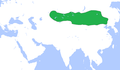
| Mongol Empire | 1206–1368 | 24,000,000 km2[1] | 
|
Avarga (1206–1235) Karakorum (1235–1260) Khanbaliq (1260–1368) | |||||
| Yuan dynasty | |||||||||
| Yuan dynasty | 1271–1368 | 14,000,000 km2 (1310)[2] | 
|
Khanbaliq (Dadu, Beijing) | |||||
| Golden Horde | 1240–1502 | 6,000,000 km2 (1310)[3] | 
|
Sarai Batu | |||||
| Great Horde | 1466–1502 | ||||||||
| Chagatai Khanate | 1225–1340s | 3,500,000 km2 (1310)[3][2] | 
|
Almaliq Qarshi | |||||
Western Chagatai Khanate
|
1340s–1370 | ||||||||
| Moghulistan | 1340–1462 | 
|
|||||||
| Kara Del Khanate | 1383–1513 | ||||||||
| Turpan Khanate | 1487–1660? | 
|
|||||||
| Yarkent Khanate | 1514–1705 | ||||||||
| Ilkhanate | 1256–1335 | 3,750,000 km2 [3][2] |

|
Maragha (1256–1265) Tabriz (1265–1306) Soltaniyeh (1306–1335) | |||||
| Chobanids | 1335–1357 | 
|
Tabriz | ||||||
| Injuids | 1335–1357 | Shiraz (Till 1353) Isfahan (1353–1357) | |||||||
| Jalayirid Sultanate | 1335–1432 | Baghdad (Till 1411) Basra (1411–1432) | |||||||
| Arghun dynasty | 1479?–1599? | ||||||||
| Genghisid Northern Yuan dynasty | |||||||||
| Northern Yuan |
1368–1635 | 5,000,000 km2 (1550)[2] |
|
Shangdu (1368–1369) Yingchang (1369–1370) Karakorum (1371–1388) | |||||
| Khalkha Khanates (Northern Yuan subject by 1635) |
late 16th century–1691 | 
|
Tüsheet Khan, Zasagt Khan, Setsen Khan and Altan Khan of the Khalkha | ||||||
| Oirats – Non-Genghisid states | |||||||||
Four Oirat
|
1399–1634 | 1,000,000 km2 (15th – late 16th) ~1,600,000 km2 (early 17th century) |
|
||||||
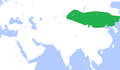
| Dzungar Khanate | 1634–1758 | 3,500,000–4,000,000 km2 |
|
Ghulja
| |||||
| Khoshut Khanate | 1642?–1717 | ~1,400,000 km2 | |||||||
| Kalmyk Khanate | 1630–1771 | ||||||||
| Timurid states (Persianate Turco-Mongol states) | |||||||||
| Timurid Empire | 1370–1507 | 4,400,000 km2 (1405)[4] | .GIF)
|
Samarkand (1370–1505) Herat(1505–1507) | |||||
| Mughal Empire | 1526–1857 | 4,000,000 km2 (1700) | 
|
Shahjahanabad/Delhi (1648–1857)
| |||||
| Other states/Khanate | |||||||||
| Khanate of Sibir | 1468–1598 | 
|
Chimgi-Tura/Qashliq | ||||||
Modern states
| Name | Years | Area | Map | Capital |
|---|---|---|---|---|
Buryat-Mongol Autonomous Soviet Socialist Republic )
(Buryats |
1919–1926[5][6][7][8] | In Kizhinginsky District, Buryatia | ||
| Republic of Oirat-Kalmyk | 1930 | Kalmykia | ||
| 1945 | Xilin Gol | Sonid | ||
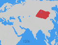
| 1911–present | Ulanbataar
|
Autonomous areas
In Russia
| Name | Years | Capital | Area | Map |
|---|---|---|---|---|
| State of Buryat-Mongolia | 1917–1921 | Chita | ||
| Mongol-Buryat Autonomous Oblast | 1922–1923 | |||
| Buryat-Mongol Autonomous Oblast | 1921–1923 | |||
Buryat-Mongol Autonomous Soviet Socialist Republic
|
1923–1958 | Ulan-Ude | 
| |
| Buryat Autonomous Soviet Socialist Republic | 1958–1992 | .svg)
| ||
Republic of Buryatia
|
1992–present | 351,300 km2 | ||
| Agin Buryat-Mongol National Okrug | 1937–1958 | Aginskoye | .svg)
| |
| Agin-Buryat National Okrug | 1958–1977 | |||
| Agin-Buryat Autonomous Okrug | 1977–2008 | |||
| Agin-Buryat Okrug | 2008–present | 9,6002 | ||
| Ust-Orda Buryat-Mongolian Autonomous Okrug | 1937–1958 | Ust-Ordynsky | 
| |
| Ust-Orda Buryat National Okrug | 1958–1978 | |||
| Ust-Orda Buryat Autonomous Okrug | 1978–2008 | |||
| Ust-Orda Buryat Okrug | 2008–present | 22,1382 | ||
| Kalmyk Autonomous Oblast | 1920–1935 1957–1958 |
Astrakhan (till 1928) Elista |
||
| Kalmyk Autonomous Soviet Socialist Republic | 1935–1943 1958–1990 |
Elista (Elstei) |
.svg)
| |
Kalmyk Soviet Socialist Republic
|
1990–1992 | |||
| Kalmyk Republic-Halmg-Tangch | 1992–1994 | |||
Kalmyk Republic
|
1994–present | 76,100 km2 |
In China
| Name | Years | Capital | Area | Map | |||||
|---|---|---|---|---|---|---|---|---|---|
| Mengjiang state | 1936–1945 | Kalgan (Khaalgan) |

| ||||||
Inner Mongolian Autonomous Region
|
1947–present | Huhhot
|
1,183,000 km2 |
.svg)
| |||||
Gansu Province
| |||||||||
| Subei Mongol Autonomous County | .png)
| ||||||||
Hebei Province
| |||||||||
| Weichang Manchu and Mongol Autonomous County | |||||||||
Heilongjiang Province
| |||||||||
| Dorbod Mongol Autonomous County | |||||||||
Jilin Province
| |||||||||
| Qian Gorlos Mongol Autonomous County | |||||||||
Liaoning Province
| |||||||||
Harqin Left Mongol Autonomous County
|
|||||||||
| Fuxin Mongol Autonomous County | |||||||||
Qinghai Province
| |||||||||
| Haixi Mongol and Tibetan Autonomous Prefecture | 
| ||||||||
| Henan Mongol Autonomous County | |||||||||
| Xinjiang Province | |||||||||
| Bayingolin Mongol Autonomous Prefecture | Korla | 462,700 km2 |

| ||||||
| Bortala Mongol Autonomous Prefecture | Bortala (Bortal) |

| |||||||
| Hoboksar Mongol Autonomous County | Hoboksar (Khovogsair) |
.png)
| |||||||
See also
Wikimedia Commons has media related to Maps of the history of Mongolia.
- History of Mongolia
- List of heads of state of Mongolia
- List of Mongol rulers
- Timeline of Mongolian history
Maps
-
 Rouran Khaganate c. 500
 -
 , 400 AD
 -
 Rouran, Northern Wei, Tuyuhun Kingdom, 500 AD
 -
 , 565 AD
 -
 Liao dynasty c. 1000
 -
 Western Liaoc. 1060
 -
 Mongol Empire in 1227
 -
 Mongol Empire
 -
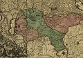
 The Dzungar Khanate (c. 1750) (in blue line)
 -
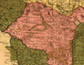
 A map of the Dzungar Khanate, by aSwedish officer in captivity there in 1716–1733, which include the region known today as Zhetysu
 -
 The Dzungar Khanate (a fragment of the map of Russian Empire of Peter The Great, that was created by a Sweden soldier in c. 1725)
 -
 This map fragment shows territories of the Dzungar Khanate as in 1706. (Map Collection of the Library of Congress: "Carte de Tartarie" of Guillaume de L'Isle (1675-1726))
 -
 Mongolia
 -
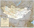 Mongolia


.svg)

References
- from the original on 17 September 2016. Retrieved 25 August 2016.
- ^ a b c d Rein Taagepera (September 1997). "Expansion and Contraction Patterns of Large Polities: Context for Russia". International Studies Quarterly 41 (3): 475–504.
- ^ a b c Jonathan M. Adams, Thomas D. Hall and Peter Turchin (2006). East-West Orientation of Historical Empires.Journal of World-Systems Research (University of Connecticut). 12 (no. 2): 219–229.
- ISSN 1076-156X.

- ^ Бидия Дандарон Archived 6 February 2016 at the Wayback Machine (Russian)
- ^ Балагатское движение Archived 28 March 2013 at the Wayback Machine (Russian)
- ^ Теократическое движение в Хоринском ведомстве Бурятии :1919–1926 гг. (Russian)
- ^ БАЛАГАТСКОЕ ДВИЖЕНИЕ Archived 14 October 2013 at the Wayback Machine (Russian)
Bibliography
- Andrews, Peter A. (1999). Felt tents and pavilions: the nomadic tradition and its interaction with princely tentage, Volume 1. Melisende. ISBN 1-901764-03-6.
- Janhunen, Juha (2003b). "Para-Mongolic". In Janhunen, J. (ed.). The Mongolic languages. pp. 1–29, 391–402.
Further reading
- Weiers, Michael (ed.) (1986): Die Mongolen. Darmstadt: Wissenschaftliche Buchgesellschaft.
- Dughlát Muhammad Haidar, Norbert Elias, Edward Denison Ross – The Tarikh-i-rashidi
- Henry Hoyle Howorth-History of the Mongols
- Herbert Franke, Denis Twitchett, John King Fairbank -The Cambridge History of China: Alien regimes and border states, 907–1368
- William Bayne Fisher, Peter Jackson, Laurence Lockhart, J. A. Boyle -The Cambridge history of Iran, 5
- Konstantin Nikolaevich Maksimov – Kalmykia in Russia's past and present national policies and administrative system