
List of Quaternary volcanic eruptions
This article is a list of historical volcanic eruptions of approximately magnitude 6 or more on the
The eruptions in the Holocene on the link: Holocene Volcanoes in Kamchatka were not added yet, but they are listed on the
Holocene eruptions
The Holocene epoch begins 11,700 years BP,[16] (10 000 14C years ago)
Since 2000 AD
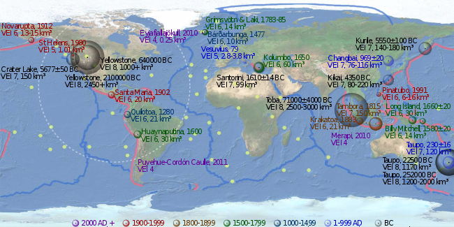
| Name and area | Date | VEI | Products | Notes |
|---|---|---|---|---|
Hunga Tonga–Hunga Ha'apai , Tonga |
2022 | 5 | 6.5 km3 (dense-rock equivalent) of tephra | The largest eruption of the 21st century |
| Puyehue-Cordón Caulle, Southern Chile | 2011 | 5 |
1000–2000 AD

| Name and area | Date | VEI | Products | Notes |
|---|---|---|---|---|
| Pinatubo, island of Luzon, Philippines | 1991, Jun 15 | 6 | 6 to 16 km3 (1.4 to 3.8 cu mi) of tephra | [2] an estimated 20 million tons of sulfur dioxide were emitted[17] |
| Mount St. Helens, Washington state, USA | 1980, May 18 | 5 | 1 to 1.1 km3 (0.2 to 0.3 cu mi) of tephra | |
| Novarupta, Alaska Peninsula | 1912, Jun 6 | 6 | 13 to 15 km3 (3.1 to 3.6 cu mi) of lava[18][19][20] | |
| Santa Maria, Guatemala | 1902, Oct 24 | 6 | 20 km3 (4.8 cu mi) of tephra[21] | |
| Mount Tarawera, Taupō Volcanic Zone, New Zealand | 1886, Jun 10 | 5 | 2 km3 (0.48 cu mi) of tephra[2] | |
| Krakatoa, Indonesia | 1883, August 26–27 | 6 | 21 km3 (5.0 cu mi) of tephra[22] | |
| Mount Tambora, Lesser Sunda Islands, Indonesia | 1815, Apr 10 | 7 | 160–213 km3 (38–51 cu mi) of tephra | an estimated 10–120 million tons of sulfur dioxide were emitted, produced the "Year Without a Summer"[23] |
| 1808 ice core event | Unknown eruption near equator, magnitude roughly half Tambora | Emission of sulfur dioxide around the amount of the 1815 Tambora eruption (ice cores from Antarctica and Greenland).[24] | ||
| 1808 | Major eruptions in Urzelina, Azores ( Urzelina eruption, fissure vent), Klyuchevskaya Sopka, Kamchatka Peninsula,[25] and Taal Volcano, Philippines.[26]
| |||
| Note: Thompson Island, northeast of Bouvet Island, South Atlantic Ocean, disappeared in the 19th century, if it ever existed.[27] | ||||
| Grímsvötn, Northeastern Iceland | 1783–1784 | 6 | ||
| Laki | 1783–1784 | 6 | 14 cubic kilometres of lava | an estimated 120 million tons of sulfur dioxide were emitted, produced a Volcanic winter, 1783, on the North Hemisphere.[28] |
| Long Island (Papua New Guinea), northeast of New Guinea | 1660 ±20 | 6 | 30 km3 (7.2 cu mi) of tephra[2] | |
Kolumbo , Santorini, Greece |
1650, Sep 27 | 6 | 60 km3 (14.4 cu mi) of tephra[29] | |
| Huaynaputina, Peru | 1600, Feb 19 | 6 | 30 km3 (7.2 cu mi) of tephra[30] | |
| Billy Mitchell, Bougainville Island, Papua New Guinea | 1580 ±20 | 6 | 14 km3 (3.4 cu mi) of tephra[2] | |
| Bárðarbunga, Northeastern Iceland | 1477 | 6 | 10 km3 (2.4 cu mi) of tephra[2] | |
| 36 to 96 km3 (8.6 to 23.0 cu mi) of tephra | 175–700 million tons of sulfuric acid;[31][32][33] only small pyroclastic flows are found at Kuwae | |||
| Mount Tarawera, Taupō Volcanic Zone, New Zealand | 1310 ± 12 | 5 | 5 km3 (1.2 cu mi) of tephra (Kaharoa eruption)[2] | |
| Quilotoa, Ecuador | 1280(?) | 6 | 21 km3 (5.0 cu mi) of tephra[2] | |
| Samalas volcano, Lombok Island, Indonesia |
1257 | 7 | 40 km3 (dense-rock equivalent) of tephra | 1257 Samalas eruption; Arctic and Antarctic ice cores provide compelling evidence to link the ice core sulfate spike of 1258/1259 A.D. to this volcano.[34][35][36] |
1 to 1000 AD

| Tianchi eruption, Paektu Mountain, border of North Korea and China | 946 AD | 6 | 40 to 98 km3 (9.6 to 23.5 cu mi) of tephra[37] | Also known as Millennium Eruption of Changbaishan |
| Eldgjá eruption, Laki system, Iceland | 934–940 AD | 6 | Estimated 18 km3 (4.3 cu mi) of lava[38] | Estimated 219 million tons of sulfur dioxide were emitted[39] |
| Ceboruco, Northwest of the Trans-Mexican Volcanic Belt | 930 AD ±200 | 6 | 11 km3 (2.6 cu mi) of tephra[2] | |
Dakataua, Northern tip of the Willaumez Peninsula, New Britain , Papua New Guinea |
800 AD ±50 | 6? | 10 km3 (2.4 cu mi)? of tephra[2] | |
| Pago, East of Kimbe, New Britain, Papua New Guinea: Witori Caldera | 710 AD ±75 | 6 | 30 km3 (7.2 cu mi) of tephra[2] | |
| Mount Churchill, eastern Alaska | 700 AD ±200 | 6 | 20 km3 (4.8 cu mi) of tephra[2] | |
| Rabaul, Rabaul Caldera, New Britain | 540 AD ±100 | 6 | 11 km3 (2.6 cu mi) of tephra[2] | Volcanic winter of 536? |
Ilopango , El Salvador |
431 AD ±2, or 539/540 AD | 7 | 106.5 km3 (25.5 cu mi) of tephra[40][2] | |
| Ksudach, Kamchatka Peninsula, Russia | 240 AD ±l00 | 6 | 20 to 26 km3 (4.8 to 6.2 cu mi) of tephra[2] | |
| Taupō Volcanic Zone, Hatepe eruption of Taupō Volcano, New Zealand | 230 AD ±16 | 7 | 120 km3 (29 cu mi) of tephra[41] | |
| Mount Vesuvius, Italy | 79 AD Oct 24 (?) | 5? | 2.8 to 3.8 km3 (0.7 to 0.9 cu mi) of tephra[2][42][43] | Pompeii eruption |
| Mount Churchill, eastern Alaska | 60 AD ±200 | 6 | 25 km3 (6.0 cu mi) of tephra[2] | |
| Ambrym, Vanuatu | 50 AD ±100 | 6 | 60 to 80 km3 (14.4 to 19.2 cu mi) of tephra[2] |
Before the Common Era (BC/BCE)
| Name and area | Date | VEI | Products | Notes |
|---|---|---|---|---|
| Okmok, Okmok Caldera , Aleutian Islands |
44 BC[44] | 6 | 40 to 60 km3 (9.6 to 14.4 cu mi) of tephra[2] | |
| Apoyeque, Nicaragua | 50 BC ±100 | 6 | 18 km3 (4.3 cu mi) of tephra[2] | |
| Raoul Island, Kermadec Islands, New Zealand | 250 BC ±75 | 6 | more than 10 km3 (2.4 cu mi) of tephra[2] | |
| Mount Meager massif, Garibaldi Volcanic Belt, Canada | 400 BC ±50 | 5 | ||
| Mount Tongariro, Taupō Volcanic Zone, New Zealand | 550 BC ±200 | 5 | 1.2 km3 (0.29 cu mi) of tephra[2] | |
| Pinatubo, island of Luzon, Philippines | 1050 BC ±500 | 6 | 10 to 16 km3 (2.4 to 3.8 cu mi) of tephra[2] | |
Kamchatka |
1350 BC (?) | 5 | more than 1.2 km3 (0.29 cu mi) of tephra | tephra layer IIAV3[2] |
| Pago, east of Kimbe, New Britain, Papua New Guinea: Witori Caldera | 1370 BC ±100 | 6 | 30 km3 (7.2 cu mi) of tephra[2] | |
| Taupō Volcanic Zone, Taupō, New Zealand | 1460 BC ±40 | 6 | 17 km3 (4.1 cu mi) of tephra[2] | |
| Avachinsky, Kamchatka | 1500 BC (?) | 5 | more than 3.6 km3 (0.86 cu mi) of tephra | tephra layer AV1[2] |
| Santorini (Thera), Greece, Youngest Caldera: Minoan eruption | 1610 BC ±14 years | 7 | 123 km3 (30 cu mi) of tephra[45] | Ended the Minoan settlement at Akrotiri and the Minoan age on Crete |
| Mount Aniakchak, Alaska Peninsula | 1645 BC ±10 | 6 | more than 50 km3 (12 cu mi) of tephra[2] | Severe global cooling[46] |
Veniaminof , Alaska Peninsula |
1750 BC (?) | 6 | more than 50 km3 (12 cu mi) of tephra[2] | |
| Mount St. Helens, Washington, USA | 1860 BC (?) | 6 | 15 km3 (3.6 cu mi) of tephra[2] | |
| Mount Hudson, Cerro, Southern Chile | 1890 BC (?) | 6 | more than 10 km3 (2.4 cu mi) of tephra[2] | |
| Black Peak, Alaska Peninsula | 1900 BC ±150 | 6 | 10 to 50 km3 (2.4 to 12.0 cu mi) of tephra[2] | |
| Long Island (Papua New Guinea), Northeast of New Guinea | 2040 BC ± 100 | 6 | more than 11 km3 (2.6 cu mi) of tephra[2] | |
| Mount Vesuvius, Italy | 2420 BC ±40 | 5? | 3.9 km3 (0.94 cu mi) of tephra | Avellino eruption[2][42][43][47] |
| Avachinsky, Kamchatka | 3200 BC ±150 | 5 | more than 1.1 km3 (0.26 cu mi) of tephra | tephra layer IAv20 AV3[2] |
| Pinatubo, island of Luzon, Philippines | 3550 BC (?) | 6 | 10 to 16 km3 (2.4 to 3.8 cu mi) of tephra[2] | |
| Talisay (Taal) caldera (size: 15 x 20 km), island of Luzon, Philippines | 3580 BC ±200 | 7 | 150 km3 (36 cu mi) of tephra[2] | |
| Haroharo Caldera, Taupō Volcanic Zone, New Zealand | 3580 BC ±50 | 5 | 2.8 km3 (0.67 cu mi) of tephra[2] | |
| Pago, New Britain | 4000 BC ± 200 | 6? | 10 km3 (2.4 cu mi)? of tephra[2] | |
| Masaya Volcano, Nicaragua | 4050 BC (?) | 6 | more than 13 km3 (3.1 cu mi) of tephra[2] | |
| Avachinsky, Kamchatka | 4340 BC ±75 | 5 | more than 1.3 km3 (0.31 cu mi) of tephra | tephra layer IAv12 AV4[2] |
| Macauley Island, Kermadec Islands, New Zealand | 4360 BC ±200 | 6 | 100 km3 (24 cu mi)? of tephra[2][48] | |
| Mount Hudson, Cerro, Southern Chile | 4750 BC (?) | 6 | 18 km3 (4.3 cu mi) of tephra[2] | |
| Mount Aniakchak, Alaska Peninsula | 5250 BC ±1000 | 6 | 10 to 50 km3 (2.4 to 12.0 cu mi) of tephra[2] | |
| Kikai Caldera (size: 19 km), Ryukyu Islands, Japan: Akahoya eruption | 5350 BC (?) | 7 | 80 to 220 km3 (19.2 to 52.8 cu mi) of tephra[2] | |
| Mashu, Hokkaido, Japan | 5550 BC ±100 | 6 | 19 km3 (4.6 cu mi) of tephra[2] | |
| Tao-Rusyr Caldera, Kuril Islands | 5550 BC ±75 | 6 | 30 to 36 cubic kilometers (7.2 to 8.6 cu mi) of tephra[2] | |
| Mayor Island / Tūhua, Taupō Volcanic Zone, New Zealand | 5060 BC ±200 | 5 | 1.6 km3 (0.38 cu mi) of tephra[2] | |
| Crater Lake (Mount Mazama), Oregon, USA | 5677 BC ±150 | 7 | 150 km3 (36 cu mi) of tephra[2] | |
| Khangar, Kamchatka Peninsula, Russia | 5700 BC ± 16 | 6 | 14 to 16 km3 (3.4 to 3.8 cu mi) of tephra[2] | |
| Crater Lake (Mount Mazama), Oregon, USA | 5900 BC ± 50 | 6 | 8 to 28 km3 (1.9 to 6.7 cu mi) of tephra[2] | |
| Avachinsky, Kamchatka | 5980 BC ±100 | 5 | more than 8 to 10 km3 (1.9 to 2.4 cu mi) of tephra | tephra layer IAv1[2] |
| Menengai, East African Rift, Kenya | 6050 BC (?) | 6 | 70 km3 (17 cu mi)? of tephra[2] | |
| Haroharo Caldera, Taupō Volcanic Zone, New Zealand | 6060 BC ±50 | 5 | 1.2 km3 (0.29 cu mi) of tephra[2] | |
Kyūshū , Japan: Aira Caldera |
6200 BC ±1000 | 6 | 12 km3 (2.9 cu mi) of tephra[2] | |
| Kurile Caldera (size: 8 x 14 km), Kamchatka Peninsula, Russia | 6440 BC ± 25 years | 7 | 140 to 170 km3 (33.6 to 40.8 cu mi) of tephra | Ilinsky eruption[2] |
| Karymsky, Kamchatka Peninsula, Russia | 6600 BC (?) | 6 | 50 to 350 km3 (12.0 to 84.0 cu mi) of tephra[2] | |
| Mount Vesuvius, Italy | 6940 BC ±100 | 5? | 2.75 to 2.85 km3 (0.7 to 0.7 cu mi) of tephra | Mercato eruption[2][42][43] |
| Fisher Caldera, Unimak Island, Aleutian Islands | 7420 BC ±200 | 6 | more than 50 km3 (12 cu mi) of tephra[2] | |
| Pinatubo, island of Luzon, Philippines | 7460 BC ±150 | 6–7?[2] | ||
| Lvinaya Past, Kuril Islands | 7480 BC ±50 | 6 | 7 to 8 km3 (1.7 to 1.9 cu mi) of tephra[2] | |
| Rotomā Caldera, Taupō Volcanic Zone, New Zealand | 7560 BC ±18 | 5 | more than 5.6 km3 (1.3 cu mi) of tephra[2] | |
| Taupō Volcano, Taupō Volcanic Zone, New Zealand | 8130 BC ±200 | 5 | 4.7 km3 (1.1 cu mi) of tephra[2] | |
| Grímsvötn, Northeastern Iceland | 8230 BC ±50 | 6 | more than 15 km3 (3.6 cu mi) of tephra[2] | |
| Ulleung, Korea | 8750 BC (?) | 6 | more than 10 km3 (2.4 cu mi) of tephra[2] | |
| Mount Tongariro, Taupō Volcanic Zone, New Zealand | 9450 BC (?) | 5 | 1.7 km3 (0.41 cu mi) of tephra[2] | |
| Taupō Volcano, Taupō Volcanic Zone, New Zealand | 9460 BC ±200 | 5 | 1.4 km3 (0.34 cu mi) of tephra[2] | |
| Mount Tongariro, Taupō Volcanic Zone, New Zealand | 9650 BC (?) | 5 | 1.6 km3 (0.38 cu mi) of tephra[2] | |
| Nevado de Toluca, State of Mexico, Trans-Mexican Volcanic Belt | 10.5 ka | 6 | 14 km3 (3.4 cu mi) of tephra | Upper Toluca Pumice[2][49] |
| GISP2 ice core event[1] | 11.258 ka |
Pleistocene eruptions
2.588 ± 0.005 million years BP, the Quaternary period and Pleistocene epoch begin.[50]
| Name and area | Date | VEI | Products | Notes | |
|---|---|---|---|---|---|
| GISP2 ice core event[1] | 12.657 ka | ||||
Vulkan Eifel , Germany |
12.900 ka | 6 | 6 km3 (1.4 cu mi) of tephra.[51][52][53][54] | ||
| Mount Vesuvius, Italy | 16 ka | 5 | Green Pumice[42][43] | ||
| Mount Vesuvius, Italy | 18.3 ka | 6 | Basal Pumice[42][43] | ||
| Santorini (Thera), Greece: Cape Riva Caldera | about 21 ka[2] | ||||
Kyūshū , Japan |
about 22 ka | 7 | more than 400 km3 (96.0 cu mi) of tephra.[55] | ||
| Taupō Volcanic Zone, Oruanui eruption, Taupō Volcano, New Zealand | around 25.6 ka [56] | 8 | Approximately 1,170 km3 (280.7 cu mi) of tephra[57][58][59][60] | ||
| Laguna Caldera (size: 10 x 20 km), South-East of Manila, island of Luzon | 27–29 ka[2] | ||||
| Alban Hills, Rome, Italy | 36 ka | 4 | Peperino Ignimbrite of Albano Maar | Sedimentation and mobility of PDCs: a reappraisal of ignimbrites’ aspect ratio[61] | |
Campi Flegrei , Naples, Italy |
39.280 ka ± 0.11 | [62] 200 cubic kilometres of lava | Campanian Tuff [1] | ||
Nariño |
40 ka | 2 km3 (0.5 cu mi) of tephra | |||
| Taupō Volcanic Zone, Rotoiti Ignimbrite, North Island, New Zealand | about 50 ka | 7 | about 240 km3 (57.6 cu mi) of tephra.[63] | ||
| Santorini (Thera), Greece: Skaros Caldera | about 70 ka[2] | ||||
| Lake Toba (size: 100 x 30 km), Sumatra, Indonesia | 73.7 ka ± 0.3[64] | 2,500 to 3,000 km3 (599.8 to 719.7 cu mi) of tephra[65] | estimated 150 to 1,000 million tons of sulfur dioxide were emitted (Youngest Toba Tuff).[66] | ||
| Aso Caldera, Kumamoto Prefecture, Japan | 90 ka | 8 | 930 to 1,860 km3 (223.1 to 446.2 cu mi) of tephra[67] | The largest known eruption in Japan | |
| Yellowstone hotspot: Yellowstone Caldera | between 70 and 150 ka | 1,000 km3 (239.9 cu mi) intracaldera rhyolitic lava flows.[2] | |||
| Galeras, Andes, Northern Volcanic Zone, Colombian department of Nariño | 150 ka | 2 km3 (0.5 cu mi) of tephra | |||
| Kos-Nisyros Caldera, Greece | 161 ka | 110 km3 (26 cu mi) | Kos Plateau Tuff.[1] | ||
| Taal Caldera, island of Luzon, Philippines | between 500 and 100 ka | 6 | ? | 6 Explosive Eruptions formed multiple overlapping calderas. [68] | |
| Santorini (Thera), Greece: Southern Caldera | about 180 ka[2] | ||||
| Taupō Volcanic Zone, Rotorua Caldera (size: 22 km wide), New Zealand | 220 ka | more than 340 km3 (81.6 cu mi) of tephra.[1] | |||
| Taupō Volcanic Zone, Maroa Caldera (size: 16 x 25 km), New Zealand | 230 ka | 140 km3 (33.6 cu mi) of tephra.[1] | |||
| Taupō Volcanic Zone, Reporoa Caldera (size: 10 x 15 km), New Zealand |
230 ka | 7 | around 100 km3 (24.0 cu mi) of tephra[2] | ||
| Taupō Volcanic Zone, Whakamaru Caldera (size: 30 x 40 km), North Island, New Zealand | around 254 ka | 8 | 1,200 to 2,000 km3 (288 to 480 cu mi) of tephra | Whakamaru Ignimbrite/Mount Curl Tephra[69][70] | |
| Taupō Volcanic Zone, Matahina Ignimbrite, Haroharo Caldera, North Island, New Zealand | 280 ka | 7 | about 120 km3 (28.8 cu mi) of tephra.[71] | ||
| Alban Hills, Rome, Italy | 365–351 ka | 6 | Villa Senni Ignimbrite >50km3 | Volcanoes of the World: Third Edition [72] | |
| Sabatini volcanic complex, Sabatini, Italy |
374 ka | 7 | more than 200 km3 (48 cu mi) | Morphi tephra.[1] | |
| Roccamonfina Caldera (size: 65 x 55 km), Roccamonfina , Italy |
385 ka | 100 to 125 km3 (24.0 to 30.0 cu mi) of tephra.[1] | |||
| Alban Hills, Rome, Italy | 407–398 ka | 6 | Pozzolane Nere Ignimbrite [72] | ||
| Alban Hills, Rome, Italy | 456–439 ka | 7 | Pozzolane Rosse Tephritic Ignimbrite >50km3 | Sedimentation and mobility of PDCs: a reappraisal of ignimbrites’ aspect ratio[61] | |
| Maipo (volcano), Andes, Southern Volcanic Zone, Chile | 450–500 ka | 7 | Diamante Caldera | ||
| Galeras, Andes, Northern Volcanic Zone, Colombian department of Nariño | 560 ka | 15 km3 (3.6 cu mi) of tephra | |||
| Lake Toba, Sumatra, Indonesia | 501 ka ±5 | Middle Toba Tuff[65] | |||
| Yellowstone hotspot: Yellowstone Caldera (size: 45 x 85 km) | 640 ka | 8 | more than 1,000 km3 (240 cu mi) of tephra | Lava Creek Tuff[2] | |
| Lake Toba, Sumatra, Indonesia | 840 ka ±30 | Oldest Toba Tuff[65] | |||
| Taupō Volcanic Zone, Mangakino Caldera, North Island, New Zealand | 0.97 Ma | more than 300 km3 (72.0 cu mi) | Rocky Hill Ignimbrite[1] | ||
| Taupō Volcanic Zone, Mangakino Caldera, North Island, New Zealand | 1.01 Ma | more than 300 km3 (72.0 cu mi) | Unit E[1] | ||
| Lake Toba, Sumatra, Indonesia | 1.2 ±0.16 Ma | Haranggoal Dacite Tuff[65] | |||
| Taupō Volcanic Zone, Mangakino Caldera, North Island, New Zealand | 1.23 Ma | more than 300 km3 (72.0 cu mi) | Ongatit Ignimbrite[1][73] | ||
| Yellowstone hotspot: Henry's Fork Caldera (size: 16 km wide) | 1.3 Ma | 7 | 280 km3 (67.2 cu mi) | Mesa Falls Tuff.[2] | |
| Yellowstone hotspot: Island Park Caldera (size: 100 x 50 km) | 2.1 Ma | 8 | 2,450 km3 (588 cu mi) | Huckleberry Ridge Tuff.[1][2] | |
| Cerro Galán Caldera, Argentina (size: 35 x 20 km) | 2.2 Ma | 8 | 1,000 km3 (240 cu mi) of dacitic magma.[74] |
Notes


- Iceland has four volcanic zones: Reykjanes (Mid-Atlantic Ridge),[75] West and North Volcanic Zones (RVZ, WVZ, NVZ) and the East Volcanic Zone (EVZ). The Mid-Iceland Belt (MIB) connects them across central Iceland. There are two intraplate belts too (Öræfajökull (ÖVB) and Snæfellsnes (SVB)).
- Iceland's East Volcanic Zone: the central volcanoes of Vonarskard and Hágöngur belong to the same volcanic system; this also applies to Bárðarbunga and Hamarinn, and Grímsvötn and Þórðarhyrna.[76][77][78]
- Laki is part of a volcanic system, centering on the Grímsvötn volcano (Long NE-SW-trending fissure systems, including Laki, extend from the central volcano).[2]
- The tholeiitic basalts.
- The central volcano of Bárðarbunga, the Veidivötn and Trollagigar fissures form one volcanic system, which extend about 100 km SW to near Torfajökull volcano and 50 km NE to near Askja volcano, respectively. The subglacial Loki-Fögrufjöll volcanic system located SW of Bárðarbunga volcano is also part of the Bárðarbunga volcanic system and contains two subglacial ridges extending from the largely subglacial Hamarinn central volcano (15 km southwest of Bárðarbunga); the Loki ridge trends to the NE and the Fögrufjöll ridge to the SW.[2]
- Iceland's East Volcanic Zone: the central volcanoes of Vonarskard and Hágöngur belong to the same volcanic system; this also applies to Bárðarbunga and Hamarinn, and Grímsvötn and Þórðarhyrna.[76][77][78]
- New Zealand, North Island, Taupō Volcanic Zone:
- The following Volcanic Centers belong to the Lake Rotoiti lie within the Ōkataina Caldera.
- Taupō Volcanic Zone, the Mangakino Volcanic Center is the westernmost and oldest rhyolitic caldera volcano in the Taupō Volcanic Zone. Mangakino is a town too.[81]
- Taupō Volcanic Zone, Maroa Volcanic Center. The Maroa Caldera formed in the Northeast corner of the Whakamaru Caldera. The Whakamaru Caldera partially overlaps with the Taupō Caldera on the South. The Orakeikorako, Ngatamariki, Rotokaua, and Wairakei hydrothermal areas are located within or adjacent to the Whakamaru caldera. Whakamaru is a town too.[2]
- The oldest volcanic zone in the North Island is the Northland Region, then the Coromandel Volcanic Zone (CVZ), then the Mangakino caldera complex and the Kapenga Caldera and then the rest of the Taupō Volcanic Zone (TVZ).
- The following Volcanic Centers belong to the
- Santorini, South Aegean Volcanic Arc. The southern Aegean is one of the most rapidly deforming regions of the Himalayan-Alpine mountain belt (Alpide belt).[82]
- The twin volcanoes of Nindirí and Masaya lie within the massive Pleistocene Las Sierras pyroclastic shield volcano.[2]
- There are two peaks in the Colima volcano complex: Nevado de Colima (4,330 m), which is older and inactive, lies 5 km north of the younger and very active 3,860 m Volcán de Colima (also called Volcán de Fuego de Colima).
- The largely submarine Kuwae Caldera cuts the flank of the Late Pleistocene or Holocene Tavani Ruru volcano, the submarine volcano Karua lies near the northern rim of Kuwae Caldera.[2]
- Bismarck volcanic arc, the Rabaul Caldera includes the sub-vent of Tavurvur and the sub-vent of Vulcan.
- Bismarck volcanic arc, Pago volcano, New Britain, Papua New Guinea, is a young post-caldera cone within the Witori Caldera. The Buru Caldera cuts the SW flank of the Witori volcano.[2]
- Sakurajima, Kyūshū, Japan, is a volcano of the Aira Caldera.
- The Mount Unzen volcanic complex, East of Nagasaki, Japan, comprises three large stratovolcanoes with complex structures, Kinugasa on the North, Fugen-dake at the East-center, and Kusenbu on the South.
Nomenclature
Each state/ country seem to have a slightly different approach, but there is an order:
- Craton, and then Province as sections or regions of a craton.
- First: volcanic arc, volcanic belt and volcanic zone.
- Second: volcanic area, caldera cluster and caldera complex.
- Third: volcanic field, volcanic system and volcanic center.
- A volcanic field is a localized area of the Earth's crust that is prone to localized volcanic activity.
- A volcanic group (aka a volcanic complex) is a collection of related volcanoes or volcanic landforms.
- Neutral: volcanic cluster and volcanic locus.
In the Basin and Range Province the volcanic fields are nested. The McDermit volcanic field, is also named Orevada rift volcanic field. The Latir-Questa volcanic locus and the Taos Plateau volcanic field seem to be in a similar area. The Southwest Nevada volcanic field, the Crater Flat-Lunar Crater volcanic zone, the Central Nevada volcanic field, the Indian Peak volcanic field and the Marysvale volcanic field seem to have no transition between each other; the Ocate volcanic field is also known as the Mora volcanic field; and the Red Hill volcanic field is also known as Quemado volcanic field.
References
- ^ a b c d e f g h i j k l m "Supplementary Table to P.L. Ward, Thin Solid Films (2009) Major volcanic eruptions and provinces" (PDF). Teton Tectonics. Retrieved 2010-03-16.
- ^ a b c d e f g h i j k l m n o p q r s t u v w x y z aa ab ac ad ae af ag ah ai aj ak al am an ao ap aq ar as at au av aw ax ay az ba bb bc bd be bf bg bh bi bj bk bl bm bn bo bp bq br bs bt bu bv bw bx by bz ca cb cc cd ce cf http://www.volcano.si.edu/world/largeeruptions.cfm Large Holocene Eruptions Archived February 13, 2010, at the Wayback Machine
- ^ S2CID 14654597. Retrieved 2010-03-18.
- S2CID 129192118.
- S2CID 54806912.
- S2CID 129520871.
- S2CID 21695750.
- .
- ^ .
- .
- ISBN 978-0-87590-998-1.
The number and magnitude of large explosive volcanic eruptions between 904 and 1865 A.D.: Quantitative evidence from a new South Pole ice core
- .
- .
- S2CID 12788441.
- S2CID 140595125.
- ^ "International Stratigraphic Chart" (PDF). International Commission on Stratigraphy. Retrieved 2009-12-23.
- .
- OCLC 156941033. Retrieved 2008-09-12.
- ^ Judy Fierstein; Wes Hildreth; James W. Hendley II; Peter H. Stauffer (1998). "Can Another Great Volcanic Eruption Happen in Alaska?". United States Geological Survey. Fact Sheet 075-98. Retrieved 2008-09-10.
- S2CID 86862398.
- ^ "Santa Maria". Global Volcanism Program. Smithsonian Institution. Retrieved 2010-03-19.
- ^ Hopkinson, Deborah (January 2004). "The Volcano That Shook the world: Krakatoa 1883". Scholastic.com. 11 (4). New York: Storyworks: 8.
- S2CID 131663534.
- .
- ^ "Документ без названия". Archived from the original on 2011-09-30. Retrieved 2010-04-03.
- ^ "Saderra Maso: Historical Taal". www.iml.rwth-aachen.de.
- ^ Baker, P. E. (1967). "Historical and geological notes on Bouvetoya" (PDF). British Antarctic Survey Bulletin. 13: 71–84. Archived from the original (PDF) on 28 February 2012. Retrieved 17 June 2010.
Abstract: it is suggested that "Thompson Island",... may have disappeared as a result of a volcanic eruption during the nineteenth century.
- ^ BBC Timewatch: "Killer Cloud", broadcast 19 January 2007
- ^ Haraldur Sigurdsson; S. Carey; C. Mandeville (1990). Assessment of mass, dynamics and environmental effects of the Minoan eruption of the Santorini volcano. Thera and the Aegean World III: Proceedings of the Third Thera Conference. Vol. II. pp. 100–12.
- ^ "Huaynaputina". Global Volcanism Program. Smithsonian Institution. Retrieved 2008-12-29.
- .
- . Retrieved 2010-03-19.
- S2CID 129403009.
- PMID 24082132.
- ^ "Mystery 13th Century eruption traced to Lombok, Indonesia". BBC News. 30 September 2013. Retrieved 1 October 2013.
- S2CID 129835887.
- S2CID 239461051.
- ^ "Katla: Eruptive History". Global Volcanism Program. Smithsonian Institution.
- ^ "Laki and Eldgjá—two good reasons to live in Hawai'". USGS – Hawaiian Volcano Observatory. 26 November 2008. Retrieved 2009-08-06.
- S2CID 202190161.
- ^ "Taupo – Eruptive History". Global Volcanism Program. Smithsonian Institution. Retrieved 2008-03-16.
- ^ a b c d e "Summary of the eruptive history of Mt. Vesuvius". Osservatorio Vesuviano, Italian National Institute of Geophysics and Volcanology. Archived from the original on December 3, 2006. Retrieved 2006-12-08.
- ^ a b c d e "Somma-Vesuvius". Department of Physics, University of Rome. Archived from the original on 2011-04-12. Retrieved 2006-12-08.
- PMID 32571905.
- S2CID 129937513.
- S2CID 166461015.
- ^ "An ancient Bronze Age village (3500 bp) destroyed by the pumice eruption in Avellino (Nola-Campania)". Archived from the original on 2012-06-18. Retrieved 2006-12-08.
- ^ Latter, J. H.|| Lloyd, E. F.|| Smith, I. E. M.|| Nathan, S. (1992). Volcanic hazards in the Kermadec Islands and at submarine volcanoes between southern Tonga and New Zealand Archived 2010-05-22 at the Wayback Machine, Volcanic hazards information series 4. Wellington, New Zealand. Ministry of Civil Defence. 44 p.
- .
- S2CID 247480436.
- .
- .
- S2CID 53973827.
- ^ Forscher warnen vor Vulkan-Gefahr in der Eifel. Spiegel Online, 13. Februar 2007. Retrieved January 11, 2008
- .
- ^ Dunbar, Nelia W
- .
- .
- .
- ^ Richard Smith, David J. Lowe and Ian Wright. 'Volcanoes – Lake Taupo', Te Ara – the Encyclopedia of New Zealand, updated 16-Apr-2007
- ^ PMID 28667271.
- S2CID 129762185.
- hdl:10289/176.
- S2CID 13742673.
- ^ . Retrieved 2010-01-20.
- S2CID 239203480.
- S2CID 219827774.
- ^ name=https://figshare.le.ac.uk/articles/thesis/A_study_of_the_stratigraphy_lithofacies_and_geochemistry_of_Taal_Caldera_Volcano_Philippines_and_its_implications_for_the_understanding_of_flooded_caldera_volcanoes/20342964
- S2CID 4332421.
The minimum total volume of tephra is 1,200 km3 but probably nearer 2,000 km3, ...
- ^ Bryan, Scott E.; Teal R. Riley; Dougal A. Jerram; Christopher J. Stephens; Philip T. Leat (2002). "Silicic volcanism: An undervalued component of large igneous provinces and volcanic rifted margins" (PDF). Geological Society of America (Special Paper 362). Retrieved 2010-03-23.
- .
- ^ ISBN 9780520947931.
- .
- ^ "Cerro Galan Caldera". Retrieved 2018-07-17.
- ^ "Reykjanes". Global Volcanism Program. Retrieved 2010-04-20.
- .
- .
- ^ "Surtsey Nomination Report 2007" (PDF). Surtsey, Island. Retrieved 2010-03-30.
- S2CID 129091056.
- .
- doi:10.1080/00288306.1998.9514803.)
{{cite journal}}: CS1 maint: multiple names: authors list (link - ISBN 0-444-52046-5