List of municipalities in Sullivan County, Pennsylvania


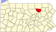
Sullivan County is located in north central Pennsylvania, about 123 miles (198 km) northwest of
Although Sullivan County has boroughs and townships, it has no
History
The land which became Sullivan County was purchased from the
According to the official state publication The Pennsylvania Manual (2011), Sullivan County was named for Pennsylvania state senator Charles C. Sullivan, who "took an active part in procuring passage of the bill" establishing the county.[2] However, according to former Pennsylvania state librarian Frederic A. Godcharles (1933) and oliver P. Williams' County Courthouses of Pennsylvania: A Guide (2001), the county is named for General John Sullivan, who led the Sullivan Expedition against the Iroquois in 1779.[3][6]
While all four boroughs were formed after Sullivan County was established, seven of the nine townships were formed while still part of Lycoming County. The first of these was Shrewsbury Township, which encompassed all of modern Sullivan County when it was formed in 1803. Elkland Township was formed from Shrewsbury in 1804, as were Cherry (1824), Davidson (1833), and Forks Townships (1833). Plunketts Creek Township was formed from Franklin and Davidson Townships in 1838, and Fox Township was formed from Elkland in 1839. When Sullivan County was formed in 1847, both Shrewsbury and Plunketts Creek Townships were split, with each county having a township of that name. Plunketts Creek Township in Sullivan County changed its name to Hillsgrove Township in 1856.[7] Sullivan County has no former townships, and no counties have been formed from it.
When formed in 1847, Sullivan County had no boroughs. The unincorporated village of Cherry Hill in Cherry Township served as the first county seat until 1850, when Laporte was founded in the geographic center of the county, and became its new county seat.[6] In 1850 the population of the county was 3,694 and it grew steadily to a peak of 12,134 in 1900. This was just after the borough of Eagles Mere was incorporated as the last of the county's municipalities, in 1899.[8] Much of this growth was fueled by lumber-based industry, but the virgin forests were almost all gone by 1900 and the population declined in eight of eleven decades since then, decreasing by a total of 47% between 1900 and 2010.[7][9]
Municipalities
| Municipality (type) |
Remarks[5][7] | Settled | Incorporated[10] | Formed from | Area | Population (2010)[1] | Map | Photo |
|---|---|---|---|---|---|---|---|---|
| Dushore (borough) | Named for Aristide Aubert Du Petit Thouars , a French settler who built the first cabin. Dushore is a corruption of "Du Petit Thouars". |
1794[7] | 1859 | Cherry Township[7] | 0.9 sq mi (2.3 km2) |
608 |  |

|
| Eagles Mere (borough) | Named for "Eagles Mere Lake" in its center, which was itself named for bald eagles and "mere", a term for a broad and shallow lake. | 1877[10] | 1899 | Shrewsbury Township[10] | 2.2 sq mi (5.8 km2) |
120 |  |

|
| Forksville (borough) | Named for the confluence ("forks") of Little Loyalsock Creek with Loyalsock Creek in the borough. |
1794[7] | 1880 | Forks Township[10] | 1.5 sq mi (3.9 km2) |
145 |  |

|
| Laporte (borough) | County seat; named for U.S. House of Representatives and last surveyor general of Pennsylvania. |
1850[6][10] | 1853 | Laporte Township[7] | 1.3 sq mi (3.3 km2) |
316 |  |

|
| Cherry Township | Named for stands of old growth cherry trees or the village of Cherry Hill. | 1816[6][10] | 1824 | Shrewsbury Township, while part of Lycoming County[6][10] | 57.8 sq mi (149.8 km2) |
1,705 |  |

|
| Colley Township | Named for William Colley, local businessman and judge. | 1823[10] | 1849 | Cherry Township[6][10] | 59.0 sq mi (152.8 km2) |
694 |  |

|
| Davidson Township | Named for Asher Davidson, an associate judge of Lycoming County. | 1806[6][10] | 1833 | Shrewsbury Township, while part of Lycoming County[7] | 78.2 sq mi (202.5 km2) |
573 |  |

|
| Elkland Township | Named for the elk that once lived in the area. | 1798[6][10] | 1804 | Shrewsbury Township, while part of Lycoming County[7] | 38.7 sq mi (100.2 km2) |
577 |  |

|
| Forks Township | Named for the . | 1794[10] | 1833 | Shrewsbury Township, while part of Lycoming County[7] | 43.9 sq mi (113.7 km2) |
377 |  |

|
| Fox Township | Named for Religious Society of Friends . |
1800[6][10] | 1839 | Elkland Township, while part of Lycoming County[7] | 38.6 sq mi (100.0 km2) |
358 |  |

|
| Hillsgrove Township | Named for John Hill, a prominent early settler, and the village of Hillsgrove he founded as Plunketts Creek Township The name was changed in 1856.[7] | 1786[6][10] | 1838[11] | Davidson and Franklin Townships, while part of Lycoming County[11] | 28.4 sq mi (73.6 km2) |
287 |  |

|
| Laporte Township | Named for John LaPorte, member of the U.S. House of Representatives and last surveyor general of Pennsylvania. | 1830[10] | 1850 | Cherry, Davidson and Shrewsbury Townships[6][10] | 53.7 sq mi (139.2 km2) |
349 |  |

|
| Shrewsbury Township | Named for Shrewsbury Township, New Jersey. | 1799[10] | 1803 | Muncy Township, while part of Lycoming County[11] | 48.1 sq mi (124.5 km2) |
319 |  |

|
Clickable map
The map shown below is clickable; click on any municipality name to be redirected to the article for that borough or township.
See also
References
Unless otherwise noted, all information on area and population comes from the
- ^ a b c "U.S. Census website". United States Census Bureau. Retrieved 2012-06-15.
- ^ a b c Trostle, Sharon, ed. (2011). "Chapter 6: Pennsylvania Local Government" (PDF). The Pennsylvania Manual. Commonwealth of Pennsylvania. pp. 6–9, 6–40. Archived from the original (PDF) on 2014-01-16. Retrieved 2012-06-15.
- ^ ISBN 0-8117-2738-6. Retrieved 2012-06-15.
- ^ Michels, Chris (1997). "Latitude/Longitude Distance Calculation". Northern Arizona University. Retrieved 2012-06-15.
- ^ OCRtypos).
- ^ a b c d e f g h i j k Godcharles, Frederic A. (1933). Pennsylvania: Political, Governmental, Military and Civil: Political and Civil History Volume (First ed.). New York, New York: The American Historical Society.
- ^ OCLC 35904783. Retrieved 2012-06-15.
- ^ "Historical Census Browser: Pennsylvania: Pennsylvania: Total Population by County 1850-1960". University of Virginia Library. Archived from the original (Searchable database) on 2007-07-15. Retrieved 2012-06-15.
- U.S. Census Bureau. Retrieved 2012-06-15.
- ^ a b c d e f g h i j k l m n o p q "Sullivan County 7th class" (PDF). Pennsylvania Historical and Museum Commission. Retrieved 2012-06-15.
- ^ a b c "Lycoming County 5th class" (PDF). Pennsylvania Historical and Museum Commission. Retrieved 2012-06-15.
External links
- "Sullivan County, Pennsylvania". Sullivan County Commissioners. Retrieved 2012-06-15. Official Sullivan County Website
- 2011 General Highway Map Sullivan County Pennsylvania (PDF) (Map). 1:65,000. Pennsylvania Department of Transportation, Bureau of Planning and Research, Geographic Information Division. Archived from the original (PDF) on 2014-06-02. Retrieved 2012-06-15.


