
Little Andaman
Hindi, English |
|---|
Little Andaman Island (
Geography
The island is in the Bay of Bengal and belongs to the Little Andaman Group, and is separated from Rutland Island in Great Andaman by the Duncan Passage. The Little Andaman Group is the counterpart of the Great Andaman island group.
The low-lying island has widespread
Climate
| Climate data for Little Andaman (Hut Bay) 1981–2010, extremes 1969–2012 | |||||||||||||
|---|---|---|---|---|---|---|---|---|---|---|---|---|---|
| Month | Jan | Feb | Mar | Apr | May | Jun | Jul | Aug | Sep | Oct | Nov | Dec | Year |
| Record high °C (°F) | 34.4 (93.9) |
35.2 (95.4) |
36.4 (97.5) |
36.4 (97.5) |
35.8 (96.4) |
36.3 (97.3) |
36.4 (97.5) |
35.6 (96.1) |
33.6 (92.5) |
34.8 (94.6) |
34.0 (93.2) |
34.4 (93.9) |
36.4 (97.5) |
| Mean daily maximum °C (°F) | 30.9 (87.6) |
31.5 (88.7) |
32.5 (90.5) |
33.2 (91.8) |
31.9 (89.4) |
30.9 (87.6) |
30.6 (87.1) |
30.3 (86.5) |
30.2 (86.4) |
30.7 (87.3) |
30.9 (87.6) |
30.7 (87.3) |
31.2 (88.2) |
| Mean daily minimum °C (°F) | 22.6 (72.7) |
21.3 (70.3) |
21.8 (71.2) |
23.0 (73.4) |
24.1 (75.4) |
24.9 (76.8) |
24.2 (75.6) |
24.5 (76.1) |
23.9 (75.0) |
23.1 (73.6) |
23.3 (73.9) |
23.3 (73.9) |
23.3 (73.9) |
| Record low °C (°F) | 14.1 (57.4) |
13.6 (56.5) |
16.3 (61.3) |
15.0 (59.0) |
18.2 (64.8) |
16.4 (61.5) |
17.8 (64.0) |
18.6 (65.5) |
15.8 (60.4) |
15.7 (60.3) |
16.6 (61.9) |
15.4 (59.7) |
13.6 (56.5) |
| Average rainfall mm (inches) | 32.7 (1.29) |
40.4 (1.59) |
50.8 (2.00) |
104.8 (4.13) |
376.7 (14.83) |
305.2 (12.02) |
330.7 (13.02) |
312.3 (12.30) |
439.1 (17.29) |
316.7 (12.47) |
270.9 (10.67) |
78.3 (3.08) |
2,658.6 (104.67) |
| Average rainy days | 1.8 | 1.6 | 2.5 | 5.2 | 15.8 | 14.5 | 14.4 | 15.9 | 16.8 | 14.3 | 11.6 | 4.5 | 118.9 |
| Average relative humidity (%) (at 17:30 IST )
|
77 | 75 | 75 | 76 | 83 | 85 | 85 | 85 | 87 | 87 | 85 | 80 | 82 |
| Source: India Meteorological Department[8][9] | |||||||||||||
Administration
Administratively, Little Andaman Island is part of Little Andaman Tehsil.[10]
Demographics
The island is home to the indigenous
Transportation
Hut Bay wharf, a deep water wharf that can be approached through a gap in the coral reef, on the east coast of the island is the entry point of Little Andaman Island. Daily boat services connect Hut Bay wharf with Port Blair in seven hours voyage. Additionally, there are a helicopter services by Pavan Hans Ltd. and a sea plane connection available between Port Blair and Hut Bay. The flight time by helicopter or sea plane is approximately 40 minutes.
| Airlines | Destinations |
|---|---|
| Jal Hans | Port Blair |
There is a road alongside the east coastal line.
Tourism
Little Andaman offers surfing, boating through the creeks, and visits to an elephant logging plantation. Butler Bay, 14 km from the Hut Bay Jetty, is a beach popular among tourists due to coral viewing, surfing and other marine activities. Tourist huts are available on the seashore itself flanked by the coconut plantation. Netaji Nagar Beach is 11 km from the Hut Bay jetty.[11]
Image gallery
-
 Outline map of the Andaman Islands, with the location of Little Andaman highlighted (in red).
 -
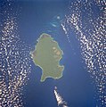 1990 Space Shuttle image of Little Andaman


See also
References
- ^ "Islandwise Area and Population - 2011 Census" (PDF). Government of Andaman.
- ^ Sailing Directions (Enroute), Pub. 173: India and the Bay of Bengal (PDF). Sailing Directions. United States National Geospatial-Intelligence Agency. 2017. p. 288.
- ^ "A&N Islands - Pincodes". 22 September 2016. Archived from the original on 23 March 2014. Retrieved 22 September 2016.
{{cite web}}: CS1 maint: bot: original URL status unknown (link) - ^ "STD Codes of Andaman and Nicobar". allcodesindia.in. Retrieved 23 September 2016.
- ^ Registration Plate Numbers added to ISO Code
- ^ "Village Code Directory: Andaman & Nicobar Islands" (PDF). Census of India. Retrieved 16 January 2011.
- ^ "Government of India, Directorate General of Lighthouses and Lightships". www.dgll.nic.in. Retrieved 18 October 2016.
- ^ "Station: Hut Bay Climatological Table 1981–2010" (PDF). Climatological Normals 1981–2010. India Meteorological Department. January 2015. pp. 329–330. Archived from the original (PDF) on 5 February 2020. Retrieved 8 February 2020.
- ^ "Extremes of Temperature & Rainfall for Indian Stations (Up to 2012)" (PDF). India Meteorological Department. December 2016. p. M1. Archived from the original (PDF) on 5 February 2020. Retrieved 8 February 2020.
- ^ "DEMOGRAPHIC – A&N ISLANDS" (PDF). andssw1.and.nic.in. Retrieved 23 September 2016.
- ^ guide
 Little Andaman travel guide from Wikivoyage