
Llano Estacado
Llano Estacado
"Staked Plains" Panhandle. The western edge is on the New Mexico side of the border, with the Texas–New Mexico border running considerably closer to the western edge of the Llano than to the eastern. | |
|---|---|
| Coordinates: 33°N 102°W / 33°N 102°W | |
| Country | |
| State | New Mexico and Texas |
| Area | |
| • Total | 83,000 km2 (32,000 sq mi) |
| Population (2013) | |
| • Total | 1,230,000 |
| • Density | 15/km2 (38/sq mi) |
The Llano Estacado (Spanish: [ˈʝano estaˈkaðo]), sometimes translated into English as the Staked Plains,[2] is a region in the Southwestern United States that encompasses parts of eastern New Mexico and northwestern Texas. One of the largest mesas or tablelands on the North American continent,[2] the elevation rises from 3,000 feet (900 m) in the southeast to over 5,000 feet (1,500 m) in the northwest, sloping almost uniformly at about 10 feet per mile (2 m/km).[3]
Naming
The Spanish name Llano Estacado is often interpreted as meaning "Staked Plains", although "
The 'Staked Plains' tale is deeply entrenched in Texas mythology, but the real interpretation of Llano Estacado is sensible geologic: it means 'stockaded' or 'palisaded' plains - which is precisely how the edge of the plains appear when viewed from below the caprock.[4]: 355
Geography and climate

The Llano Estacado lies at the southern end of the
The Llano Estacado has a cold semiarid climate (Köppen BSk), characterized by long, hot summers and cold winters. Rainfall is relatively low; the entire region receives fewer than 23 in (580 mm) of rainfall annually, and the western part receives as little as 14 in (360 mm). High summer temperatures (average high July temperature above 90 °F or 32 °C) mean that most of the small amount of precipitation is lost to evaporation, making dryland farming difficult.[2]
The Texas State Historical Society states it covers all or part of 33 Texas counties, six fewer than as depicted by a US Geological Survey map, and four New Mexico counties.[2]
As depicted by a US Geological Survey map, the Llano Estacado includes all or part of these Texas counties:[12][13]
|
It also includes all or part of the following New Mexico counties:
Several interstate highways serve the Llano Estacado.
History
Spanish
I reached some plains so vast, that I did not find their limit anywhere I went, although I traveled over them for more than 300 leagues ... with no more land marks than if we had been swallowed up by the sea ... there was not a stone, nor bit of rising ground, nor a tree, nor a shrub, nor anything to go by.[2][15]
In the early 18th century, the Comanches expanded their territory into the Llano Estacado, displacing the Apaches who had previously lived there. The region became part of the Comancheria, a Comanche stronghold until the final defeat of the tribe in the late 19th century.[16] The Comanche war trail extended from Llano Estacado to the Rio Grande into Chihuahua, "the trail ran southwesterly through Big Spring to the Horsehead Crossing of the Pecos River, then forked southward to the Comanche Springs where it divided, one part of the trail crossing the great river near Boquillas and the other at Presidio."[17]: 122
Rachel Plummer, while a captive of the Comanche in 1836, mentioned the "table lands between Austin and Santa Fe".[18]
After his 1852 expedition to explore the headwaters of the
When we were upon the high table-land, a view presented itself as boundless as the ocean. Not a tree, shrub, or any other object, either animate or inanimate, relieved the dreary monotony of the prospect; it was a vast-illimitable expanse of desert prairie . ... the great Sahara of North America. it is a region almost as vast and trackless as the ocean—a land where no man, either savage or civilized permanently abides ... a treeless, desolate waste of uninhabitable solitude, which always has been, and must continue uninhabited forever.[19]
During the 1854 Marcy-Neighbors expedition, Dr. George Getz Shumard noted, "Beyond the mountain appeared a line of high bluffs (the Llano Estacado) which in the distance looked like clouds floating upon the horizon."[20]: 145
Herman Lehmann was captured by the Apache in 1870 and described the Llano Estacado as "open, but not exactly a desert".[21]
Robert G. Carter described it in 1871 while pursuing Quanah Parker with Ranald S. Mackenzie, "... all were over and out of the canyon upon what appeared to be a vast, almost illimitable expanse of prairie. As far as the eye could reach, not a bush or tree, a twig or stone, not an object of any kind or a living thing, was in sight. It stretched out before us-one uninterrupted plain, only to be compared to the ocean in its vastness."[22]
In August 1872, Mackenzie was the first to successfully lead troops across the Staked Plains preparatory to the Battle of the North Fork of the Red River.[23]
Billy Dixon described the area while hunting buffalo in June 1874: "All of us hunters acquainted with the habits of the buffalo knew that the herds would soon be coming north from the Staked Plains region where they had spent the winter ... moved by that strange impulse that ... caused them to change their home and blacken the Plains with their countless, moving forms."[24]
Zane Grey, in his novel The Thundering Herd (1925), offered the following explanation for the name Llano Estacado: "Thet name Llano Estacado means Staked Plain," said the Texan. "It comes from the early days when the Spanish Trail from Santa Fe to San Antone was marked by 'palos,' or stakes. There was only two trails across in them days an' I reckon no more now. Only the Indians know this plain well an' they only run in heah to hide awhile. Water an' grass are plentiful in some parts, an' then there's stretches of seventy miles dry an' bare as a bone."
In the latter part of the 19th century, the Llano was a refuge for the bands of Kiowas and Comanches who did not wish to be confined to reservations in Indian Territory, in present-day Oklahoma. One of their last battles against the US Army was fought on 28 September 1874 in the Battle of Palo Duro Canyon.
Charles Goodnight described what it takes to be a scout: "... the trained ear should be able to tell the sound, whether it was made by man or beast or bird ... as a human voice echoes more than all others ... of course, on the Staked Plains we have not this advantage as there is nothing to create an echo."[25]
Today, most of the area's population is localized in the principal cities of
-
 Map ofTexas countieswith population density
 -
 Lubbock, Texas, the largest city on the Llano
 -
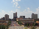
 A shot of downtown Amarillo, Texas
 -
 Midland, "The Tall City" of West Texas
 -
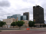
 Downtown Odessa


Geology


The
When the weather is dry, they are dusty, round, gray, usually unvegetated flats, as observed from the highway. But after a High Plains thunderstorm, water quickly fills the ponds, only later soaking into the underlying porous
sandstones just below the surface to add to the groundwater in the Ogallala aquifer. Early pioneers depended dearly on water from these surface ponds for themselves and their livestock, considering how few streams are on the High Plains. But rains didn't always come, and the ponds dried up frequently. The 20th century has witnessed a concerted effort to tap the more reliable Ogallala water sands. Predictably, the consequent high dependency on groundwater has removed more water than is naturally replaced, raising concern for Panhandle citizens and planners as to future water supplies.[4]: 357
The
Economy
The economy of the Llano Estacado is predominantly agricultural, with farming of various crops prevalent, as is
Overuse of the aquifer in the past has persuaded some farmers to return to dryland crops, leading to less rainwater reaching the playas.[27]

"Cotton, grain sorghum, corn, wheat, peanuts, sunflowers, grapes, vegetables, and cattle produced in the region literally go around the world. Their economic impact on our area is in the billions of dollars ... and the availability of water is a key factor influencing the region's agribusiness economy."[28]
One of the largest economic drivers on the Llano Estacado is in energy production, with the region experiencing significant activity for producing
In popular culture
- The 2020 song "West Texas In My Eye" by The Panhandlers features the lyrics, "Where the Llano Estacado rises up to meet the sky/I ain't crying, that's West Texas in my eye."[29]
- María Dolores Gonzales wrote a creative nonfiction memoir about her time in Llano Estacado, called Atop the Windmill: I Could See Forever.[30]
- The region is mentioned in the song “Sweet Amarillo” by the band Old Crow Medicine Show.
- Several works of German author Karl May are set in the Llano Estacado, although the area is described as a sand desert, featuring large stakes marking safe routes. Recurrent dramatic subplots revolve around highwaymen reinstalling some sections of stakes, so the detour would abruptly end in the deep desert, and mislead travelers would run out of water, getting weak, sick or even dead, and eventually making an easy prey.
- Colter Wall mentions the Llano Estacado in his 2023 song "The Last Loving Words", alongside other geographical landmarks in Texas. [31]
See also
- Caprock Canyons State Park and Trailway
- Caprock Chief
- Canyon Valley
- Double Mountain Fork Brazos River
- Duffy's Peak
- Estacado, Texas
- List of geographical regions in Texas
- Mushaway Peak
- Mount Blanco
- Ogallala Aquifer
- Palo Duro Canyon
- Prairie Dog Town Fork Red River
- Salt Fork Brazos River
- Settles Hotel
- Yellow House Canyon
References
- ^ Cummins, W.F., 1892. Report on the geography, topography, and geology of the Llano Estacado or Staked Plains with notes on the geology of the country west of the Plains. In: Dumble, E.T. (Ed.), Third annual report of the Geological Survey of Texas 1891. Austin: Henry Hutchings, State Printer, pp. 129-223.
- ^ a b c d e f g h i j k Leatherwood, Art (June 15, 2010). "Llano Estacado". Handbook of Texas Online. Texas State Historical Association.
- ^ Wendorf, F., 1961. Paleoecology of the Llano Estacado, Vol. 1, Santa Fe: NM, The Museum of New Mexico Press, Fort Burgwin Research Center Publication
- ^ ISBN 0-8784-2265-X.
- ISBN 9780598277770. Retrieved 19 August 2021.
- ISBN 0-8263-0082-0.
- ISBN 978-1-85109-603-9.
- .
- .
- JSTOR 1311091.
- JSTOR 2845189.
- ^ "Texas Conservation Action Plan Ecoregions" (PDF). As depicted by the southern half of the High Plains--in conjunction with an aerial map of the region: Texas Parks and Wildlife Department. 20 May 2011. Retrieved 1 October 2013.
- ^ "Ecoregions of Texas" (PDF). As depicted by items 25i,25j,25k on the map in conjunction with a county names map: U.S. Geological Survey. Retrieved 1 October 2013.
{{cite web}}: CS1 maint: location (link)[permanent dead link] - ISBN 978-0528942488.
- ^ 300 Spanish leagues ≈ 780 mi or 1,255 km
- ISBN 978-0-300-12654-9. Online at Google Books
- ^ ISBN 0292770340
- ASIN B0006CIXBU.
- ^ William T. Hagan, Charles Goodnight: Father of the Texas Panhandle (Norman, Oklahoma: University of Oklahoma Press, 2007), pp. 30-31
- ^ Neighbors, K.F., 1975, Robert Neighbors and the Texas Frontier, 1836-1859, Waco: Texian Press
- ISBN 0826314171
- ^ Carter, R.G., On the Border with Mackenzie, 1935, Washington D.C.: Eynon Printing Co., p. 187
- ISBN 978-0876112465.
- ASIN B000ZBYIZM.
- Panhandle Plains Historical Museum, Canyon, Texas
- ^ Calvert, J.B., The Llano Estacado, University of Denver, 1999
- ^ Playa Lakes United States Environmental Protection Agency. Retrieved: 2012-10-15.
- ^ Llano Estacado Regional Water Planning Group
- ^ "Lyrics". The Panhandlers. Retrieved 2022-04-05.
- ^ Gonzales, María Dolores. "Atop the Windmill I Could See Forever". Amazon.
- ^ Wall, Colter. "Lyrics". genius.com. Retrieved 24 April 2024.
External links
Llano Estacado.
- Public domain photos of the Llano Estacado
- "The Definition of 'Llano Estacado' in the U.S. and Around the World", ThoughtCo.
- El Llano Estacado: The Vast, Staked, Palisaded Plain
- Detailed map of the Llano Estacado in KML (Google Earth) format
| International | |
|---|---|
| National | |