
Lofoten
| Area | 1,227 km2 (474 sq mi) |
|---|---|
| Administration | |
Norway | |
| Demographics | |
| Population | 24,500 |
| Additional information | |
| Official website | lofoten |
Lofoten (
Etymology
Lofoten (
Another name one might come across, is "Lofotveggen" or the Lofoten wall. The archipelago looks like a closed wall when seen from elevated points around Bodø or when arriving from the sea, some 100 kilometres (62 miles) long, and 800–1,000 metres (2,600–3,300 feet) high.
History

According to Robert M. D'Anjou and others: "There is evidence of human settlement extending back at least 11,000 years in Lofoten, and the earliest archaeological sites ... are only about 5,500 years old, at the transition from the early to late Stone Age." Iron Age agriculture, livestock, and significant human habitation can be traced back to c. 250 BC.[1]

The town of Vågan (
The islands have for more than 1,000 years been the centre of great
In March 1941 the islands were raided by
As of 2017, the islands attract one million tourists a year.[3]
Geography

Lofoten is located at the 68th and 69th parallels north of the Arctic Circle in North Norway. Lofoten encompasses the municipalities of Vågan, Vestvågøy, Flakstad, Moskenes, Værøy, and Røst. The principal islands, running from north to south are:
- Southern tip of Hinnøya.
- Southern 60% (approx.) of Austvågøy (526.7 square kilometres (203.4 square miles) in total 68°20′N 14°40′E / 68.333°N 14.667°E)
- Gimsøya (46.4 square kilometres (17.9 square miles) 68°18′N 14°11′E / 68.300°N 14.183°E)
- Vestvågøy (411.1 square kilometres (158.7 square miles) 68°10′N 13°45′E / 68.167°N 13.750°E)
- Flakstadøya (109.8 square kilometres (42.4 square miles) 68°5′N 13°20′E / 68.083°N 13.333°E)
- Moskenesøya (185.9 square kilometres (71.8 square miles) 67°55′N 13°0′E / 67.917°N 13.000°E)

Hamnoy

Further to the south are the small and isolated islands of Værøy (67°40′N 12°40′E / 67.667°N 12.667°E) and Røst (67°37′N 12°7′E / 67.617°N 12.117°E). The total land area amounts to 1,227 square kilometres (474 square miles), and the population totals 24,500. Many will argue that Hinnøya, the northern part of Austvågøy and several hundred smaller islands, skerries and rocks to the east of Austvågøy are also part of the Lofoten complex. Historically, the territorial definition of Lofoten has changed significantly. Between the mainland and the Lofoten archipelago lies the vast, open Vestfjorden, and to the north is Vesterålen. The principal towns in Lofoten are Leknes in Vestvågøy and Svolvær in Vågan. The main islands are joined to each other and the mainland by road bridges.
The Lofoten Islands are characterised by their mountains and peaks, sheltered inlets, stretches of seashore and large virgin areas. The highest mountain in Lofoten is Higravstinden (1,161 metres (3,809 feet)) in Austvågøy; the Møysalen National Park just northeast of Lofoten has mountains reaching 1,262 metres (4,140 feet). The famous Moskstraumen (Malstrøm) system of tidal eddies is located in western Lofoten, and is indeed the root of the term maelstrom.
Geology

Lofoten is a
In Vestvågøya mountains have steep slopes towards the open sea in the northwest and southeast while slopes pointing towards the interior of the island are more gentle. This is the result of erosion acting on a landscape that has been uplifted along NE–SW-trending faults in the margins of Lofoten while the interior axis has remained more stable.[4] In tectonic terms mountains are half-grabens and faults are of the dip-slip type.[4]
The sea around Lofoten is known to host significant oil reserves: 1.3 bn barrels. Oil extraction in the Lofoten area is prohibited.[3]
Wildlife
The sea is rich with life, and the world's largest
occur in Lofoten, but not further north.Birds
Some 27,000 ha of marine waters along the north-western coasts and fjords of the Lofoten Islands has been designated an
Climate
Lofoten features a mostly
Strong winds can occur in late autumn and winter. Snow and sleet are not uncommon in winter. The mountains can have substantial amounts of snow, and avalanches may come down from the steep slopes.
In Svolvær, the sun is above the horizon continuously ("midnight sun") from 25 May to 17 July, and in winter the sun does not rise from 4 December to 7 January. In Leknes, the sun is above the horizon from 26 May to 17 July, and in winter the sun does not rise from 9 December to 4 January.
The temperature in the sea has been recorded since 1935. At 1 metre (3 feet 3 inches) depth in the sea near Skrova, water temperatures vary from a low of 3 °C (37 °F) in March to 14 °C (57 °F) in August, some years peaking above 17 °C (63 °F). November is around 7–8 °C (45–46 °F). At a depth of 200 metres (660 feet), the temperature is near 8 °C (46 °F) all year.[12] Skrova lighthouse on an island near Svolvær has the longest recording of air temperature in Lofoten. The warmest temperature recorded is 30.4 °C (86.7 °F) in June 1972. The coldest temperature recorded is −15.1 °C (4.8 °F) in February 1966. Last overnight freeze in June was in 1962, and last freeze in September was in 1986. Skrova and nearby Svolvær are among those places in North Norway which can record what Norwegians know as "tropical nights" when the overnight low does not go below 20 °C (68 °F). The warmest night recorded in Lofoten was July 1 1972 at Skrova with low 23.8 °C (74.8 °F),[13] and the earliest in summer was June 10th 2011 with low 21.5 °C (70.7 °F).[14] The wettest month recorded is December 1936 with 227 mm, and the driest is January 2014 with 0.9 mm.
| Climate data for Skrova 1991-2020 (14 m, precipitation days 1961-90, extremes 1934-2022) | |||||||||||||
|---|---|---|---|---|---|---|---|---|---|---|---|---|---|
| Month | Jan | Feb | Mar | Apr | May | Jun | Jul | Aug | Sep | Oct | Nov | Dec | Year |
| Record high °C (°F) | 10.6 (51.1) |
8.5 (47.3) |
10 (50) |
17.4 (63.3) |
24.3 (75.7) |
30.4 (86.7) |
29.8 (85.6) |
27 (81) |
22.1 (71.8) |
17.1 (62.8) |
13 (55) |
11.2 (52.2) |
30.4 (86.7) |
| Mean daily maximum °C (°F) | 2.4 (36.3) |
1.6 (34.9) |
2.2 (36.0) |
4.8 (40.6) |
9 (48) |
13 (55) |
16.1 (61.0) |
15.4 (59.7) |
12 (54) |
7.8 (46.0) |
5.4 (41.7) |
3.6 (38.5) |
7.8 (46.0) |
| Daily mean °C (°F) | 0.9 (33.6) |
0.2 (32.4) |
0.7 (33.3) |
3.1 (37.6) |
6.8 (44.2) |
10.6 (51.1) |
13.6 (56.5) |
13.3 (55.9) |
10.4 (50.7) |
6.5 (43.7) |
4 (39) |
2.2 (36.0) |
6.0 (42.8) |
| Mean daily minimum °C (°F) | −1 (30) |
−1.6 (29.1) |
−0.9 (30.4) |
1.4 (34.5) |
4.9 (40.8) |
8.6 (47.5) |
11.5 (52.7) |
11.5 (52.7) |
8.8 (47.8) |
4.9 (40.8) |
2.2 (36.0) |
0.3 (32.5) |
4.2 (39.6) |
| Record low °C (°F) | −12.7 (9.1) |
−15.1 (4.8) |
−12.3 (9.9) |
−8.5 (16.7) |
−3.4 (25.9) |
−1.2 (29.8) |
3.7 (38.7) |
3.9 (39.0) |
−1.4 (29.5) |
−4.5 (23.9) |
−10.7 (12.7) |
−11.9 (10.6) |
−15.1 (4.8) |
| Average precipitation mm (inches) | 89 (3.5) |
81 (3.2) |
65 (2.6) |
49 (1.9) |
46 (1.8) |
37 (1.5) |
50 (2.0) |
48 (1.9) |
79 (3.1) |
88 (3.5) |
97 (3.8) |
90 (3.5) |
819 (32.3) |
| Average precipitation days (≥ 1.0 mm) | 14 | 11 | 11 | 10 | 9 | 9 | 11 | 10 | 15 | 17 | 15 | 15 | 147 |
| Source 1: Norwegian Meteorological Institute[15] | |||||||||||||
| Source 2: Noaa WMO averages 91-2020 Norway [16] | |||||||||||||
Even if the islands are not that large, there are climatic differences. Værøy and Røst furthest west have the warmest winters, but summer highs are cooler. Vestvågøy with the town Leknes has lowland in the interior of the island with mountains nearby; winters here are slightly colder and much wetter than at Skrova, while summers are drier and comparable.
| Climate data for Leknes Airport 1991–2020 | |||||||||||||
|---|---|---|---|---|---|---|---|---|---|---|---|---|---|
| Month | Jan | Feb | Mar | Apr | May | Jun | Jul | Aug | Sep | Oct | Nov | Dec | Year |
| Mean daily maximum °C (°F) | 1 (34) |
1 (34) |
2 (36) |
6 (43) |
10 (50) |
12 (54) |
16 (61) |
15 (59) |
12 (54) |
8 (46) |
4 (39) |
3 (37) |
8 (46) |
| Daily mean °C (°F) | 0 (32) |
−0.6 (30.9) |
0 (32) |
2.8 (37.0) |
6.5 (43.7) |
9.9 (49.8) |
12.8 (55.0) |
12.2 (54.0) |
9.4 (48.9) |
5.2 (41.4) |
2.6 (36.7) |
1 (34) |
5.2 (41.3) |
| Mean daily minimum °C (°F) | −2 (28) |
−2 (28) |
−2 (28) |
1 (34) |
4 (39) |
8 (46) |
11 (52) |
10 (50) |
7 (45) |
4 (39) |
2 (36) |
0 (32) |
3 (38) |
| Average precipitation mm (inches) | 203 (8.0) |
174 (6.9) |
161 (6.3) |
93 (3.7) |
74 (2.9) |
45 (1.8) |
38 (1.5) |
78 (3.1) |
123 (4.8) |
161 (6.3) |
173 (6.8) |
223 (8.8) |
1,546 (60.9) |
| Source 1: Norwegian Meteorological Institute[15] | |||||||||||||
| Source 2: Weatheronline climate robot (avg highs/lows) [17] | |||||||||||||
Sport
Mountaineering and rock climbing

Lofoten offers many rock climbing and mountaineering opportunities. It has 24 hours of daylight in the summer and has Alpine-style ridges, summits and glaciers, but at a height of less than 1,200 metres (3,900 feet). The main centre for rock climbing is Henningsvær on Austvågøya.
The main areas for mountaineering and climbing are on Austvågøy and Moskenesøya. Moskenesøya features remote and serious mountaineering whereas Austvågøy is very popular area for rock climbing.[citation needed]
Football
Lofoten has one of the world's most noteworthy football pitches. Located in the village of Henningsvaer, the pitch at Henningsvaer Stadium rests on a rocky islet and has no actual seats.[18]
Surfing
Unstad is one of its better known locations for surfing. Every September surfers from around the world visit to compete in the Lofoten Masters.[19]
Cycling

There is a well-marked cycling route that goes from Å in the south and continues past Fiskebøl in the north. The route is part public road, part cycle-path with the option to bypass all of the tunnels by either cycle-path (tunnels through mountains) or boat. Traffic is generally light, although in July there may be a lot of campervans. Some of the more remote sections are on gravel roads. There is a dedicated cycling ferry which sails between Ballstad and Nusfjord, allowing cyclists to avoid the long, steep Nappstraum tunnel. The route hugs the coastline for most of its length where it is generally flat. As it turns inland through the mountain passes there are a couple of 300–400-metre (980–1,310-foot) climbs.[citation needed]
The Lofoten Insomnia Cycling Race[20][full citation needed] takes place every year around midsummer, possible in the midnight sun, but certainly in 24-hour daylight, along the whole Lofoten archipelago.
The Arctic Race of Norway, the world's northernmost professional stage race on road bike which takes place every year in Northern Norway, crossed the Lofoten islands during its first edition in August 2013. As of 2015[update], the race was planned to be back in 2019 from Thursday 15 August to Sunday 18 August. The first two stages will cross the Lofoten archipelago from west to east.[21][full citation needed]
Transportation

The European road
Lofoten is also served by a number of small airports:
- Leknes Airport (101,757 passengers in 2014)
- Svolvær Airport, Helle(74,496 passengers in 2014)
- Røst Airport (9,889 passengers in 2014), which mainly offers flights to Bodø.
- A heliport at Værøy (9,420 passengers in 2014)
- Stokmarknes Airport, Skagen(93,782 passengers in 2016) is located in Vesterålen.
- Harstad/Narvik Airport, Evenes has direct flights to Oslo and Trondheim.
Bodø is often used as a hub for travel to Lofoten. In addition to air travel there is a ferry connecting Bodø to
.Culture
Visual arts
Lofoten International Art Festival (Lofoten internasjonale kunstfestival, LIAF) is a contemporary art biennale with no set venue or location on the archipelago.[24] Artists who have participated include Kjersti Andvig, Michel Auder, A K Dolven, Ida Ekblad, Elmgreen & Dragset, and Lawrence Weiner.[25][26][27][28]
The North Norwegian Art Centre (Nordnorsk Kunstnersenter, NNKS) was established in Svolvær in 1979.[29]
KaviarFactory is a privately-owned contemporary art space in Henningsvær.[30]
The Nordland School of Art and Film (Nordland kunst- og filmhøgskole, NKFS) was established in Kabelvåg in 1997.[31]
In popular culture
Literature
- Edgar Allan Poe's short story "A Descent into the Maelström" tells the story of a man who survived his ship being drawn into and swallowed by Moskstraumen.
- Many of the novels of Knut Hamsun are situated in the Lofoten.
- Nautilus having fallen into the Maelström, and Prof. Aronnax, Conseil and Ned Land, who had been attempting to escape when the Nautilus began its fall, washed up on an island in the Lofotens.
- Johan Bojer's novel The Last of the Vikings (1922) tells the story of the Lofoten cod fishermen.
- In Ole Edvart Rølvaag's novel Giants in the Earth, the Norwegian protagonists settling in Dakota Territory are immigrants from Lofoten.
- The poem "Pilot Nagel" from the Greek sailor-poet Nikos Kavvadias tells the story of the Norwegian sailor Nagel Harbor, who dies at the port of Colombo, while escorting a steamer tank on its way to his homeland, the Lofoten islands.
Films
- In the film Maelström, Lofoten is where the ashes of Annstein Karson are distributed.
- In the film The Sunlit Night, Lofoten is where the protagonist Frances decides to aid a fellow critically reviled artist.
Television
- The Norwegian television crime drama series Twin, which premiered on 27 October 2019 on NRK, is set in the Lofoten Islands.
- The Grand Tour: A Scandi Flick special was filmed in Lofoten in 2022.
Paintings
Norwegian painter Gunnar Berg was known for his paintings of his native Lofoten. He principally painted scenes of the everyday life of the local fishermen. Other artists whose work has been associated with Lofoten include Adelsteen Normann, Otto Sinding, Christian Krohg, Theodor Kittelsen, Lev Lagorio,[32] Ernst Wilhelm Nay and Ingo Kühl.
-
 Fiskebåter ved Reine by Gunnar Berg (without year)
 -
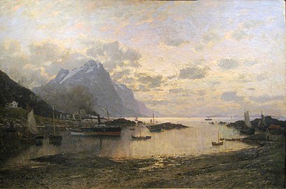 Dampskipsanløp i Lofoten by Adelsteen Normann (1885)
 -
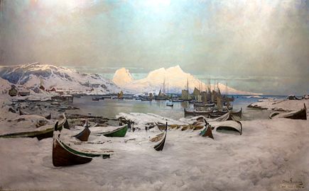 Winter in Lofoten by Otto Sinding (1886)
 -
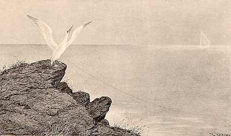 Fra Lofoten by Theodor Kittelsen (1890)
 -
 Moskstraumen I, Reine, Lofoten, by Ingo Kühl (1999)


Music
In 2004, Nurse with Wound broadcast 24 unexpected radio transmissions from the Lofoten Islands,[citation needed] whose sounds were sourced from the environment and objects found in Lofoten. These recordings are included on their three releases entitled Shipwreck Radio.[33]
See also
References
- PMID 23185025.
- ^ "Norway – Vestvågøy – Vendalsjord". www.travels-in-time.net. Archived from the original on 2021-01-22. Retrieved 2021-02-25.
- ^ a b c d M.F. (29 Aug 2017). "Why Norway may leave $65bn worth of oil in the ground". The Economist.
- ^ . Retrieved January 29, 2019.
- .
- ^ Lidmar-Bergström, K.; Näslund, J.O. (2002). "Landforms and uplift in Scandinavia". In Doré, A.G.; Cartwright, J.A.; Stoker, M.S.; Turner, J.P.; White, N. (eds.). Exhumation of the North Atlantic Margin: Timing, Mechanisms and Implications for Petroleum Exploration. Geological Society, London, Special Publications. The Geological Society of London. pp. 103–116.
- S2CID 129912355.
- ^ "Røst Reef, 40 km long". Archived from the original on February 8, 2007.
- ^ "Rødlista 2021 – Hedlundia hybrida: Ekspertenes oppsummering" [Redlist for 2021 – Hedlundia hybrida: Expert summary]. Artsdatabanken (in Norwegian). Retrieved 15 December 2023.
Rognasal Hedlundia hybrida (tidligere Sorbus hybrida) vurderes som livskraftig (LC). Dette er en vidt utbredt art i låglandet og kyststrøk nord til ytre Lofoten.
[The rowan-whitebeam Hedlundia hybrida (formerly Sorbus hybrida) is assessed as viable (LC). This is a widely distributed species in the lowlands and coastal areas north to outer Lofoten.] - ^ "Lofoten". BirdLife Data Zone. BirdLife International. 2021. Retrieved 2021-12-12.
- ^ Martin, Stephen. Penguin. Reaktion Books Ltd., 2009, p. 22.
- ^ "Faste stasjoner". www.imr.no.
- ^ "Vær og Vind - NORGE – Alle tropenetter - Powered by Proweb". www.verogvind.net.
- ^ Nordland, Avisa (2011). "Varmerekord og tropenatt". www.an.no (in Norwegian).
- ^ a b "EKlima". sharki.oslo.dnmi.no. Archived from the original on 2021-01-28. Retrieved 2021-01-27.
- ^ "NOAA WMO normals Norway 1991-2020". www.nodc.noaa.gov.
- ^ "Weatheronline climate robot Leknes Airport". Weather online. Retrieved 27 March 2021.
- ^ "Amusing Planet: Stadium in Henningsvær". Retrieved 12 November 2020.
- ^ "Ekstremsurferne Inntar Lofoten". nrk.no. Opphavsrett NRK. 4 August 2012.
- ^ "Zalaris Lofoten Insomnia". www.lofoteninsomnia.no.
- ^ "Official route of Arctic Race of Norway 2021". www.arctic-race-of-norway.com.
- ^ "How to Get to the Lofoten Islands in Norway - Around The World With Me". aroundtheworldwithme.com. 2023-06-11. Retrieved 2023-07-09.
- ^ "Torghatten Nord AS". www.torghatten-nord.no. Retrieved 2023-07-09.
- ^ "Lofoten International Art Festival LIAF (Norway)". Biennial Foundation. Retrieved 2021-07-01.
- ISSN 1504-0925. Retrieved 2021-07-01.
- ISSN 1504-0925. Retrieved 2021-07-01.
- ISSN 1504-0925. Retrieved 2021-07-01.
- ISSN 0004-3532. Retrieved 2021-07-01.
- ^ "Forsiden". NNKS. Retrieved 2021-07-01.
- from the original on 2010-07-17.
- ^ "Nordland kunst- og filmhøgskole". NKFS (in Norwegian Bokmål). Retrieved 2021-07-01.
- ^ "The Northern Lights Route – Lofoten in Paintings". www.ub.uit.no.
- ^ "Lofoten Northern Light - Experience the Aurora borealis in Norway". lofotennorthernlight.com.
Further reading
- Rines, George Edwin, ed. (1920). . Encyclopedia Americana.
- Dyer, Anthony; Baddeley, John; Robertson, Ian H. (2006). Walks and Scrambles in Norway. Rockbuy Limited. ISBN 9781904466253.
- Webster, Ed (1994). Climbing in the Magic Islands (in Norwegian). Henningsvaer, Norway: Nord Norsk Klatreskole. ISBN 9788299319904.
- Craggs, Chris; Enevold, Thorbjørn (2008). Lofoten Rock. Rockfax Ltd. ISBN 9781873341667.
External links


| International | |
|---|---|
| National | |